DESIGNING ESRIS VECTOR TILE BASEMAPS Wesley Jones Andy

DESIGNING ESRI’S VECTOR TILE BASEMAPS Wesley Jones Andy Skinner

Overview • Session will look at the provided esri vector basemaps • Explain the design decisions • View the result

Advantages of Vector • Size • Processing time • Versatility • Simplicity • Standardization • Still combine with Raster • Customization

The Basemap Set Andy Skinner
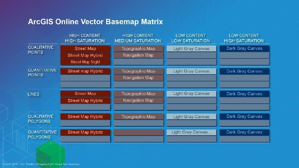

High Content / High Saturation Basemaps and reference maps These maps are designed to have impact, and to work as reference maps as well as base maps. They include: • The Street Map (with and without hillshade) • The Street Map hybrid * • The Night Map

The Street Map • Works well for transportation subjects • Works well with Qualitative Points • Not so good for Quantitative data.

The Street Map • With and without relief
 • Designed to be used in low light conditions")
The Street Map (Night) • Designed to be used in low light conditions

Low Content / Low Saturation These maps are designed to be as neutral as possible, with a minimum of content. They include: • Light Gray Canvas Map • Dark Gray Canvas Map • They work with all types of data… • … as long as there is enough content.

The Light Gray Canvas Map • Most of the content is concentrated in the bottom 30% of the tonal range

The Dark Gray Canvas Map • Most of the content is concentrated in the top 30% of the tonal range

High Content / Medium Saturation Basemaps These maps are designed to … They include: • The Topographic Map • The Navigation Map • The Street Map Hybrid*

The Topo Map • Multi Directional Hillshade • Updated Design • More content coming

The Hybrid Map • New* • Imagery

The Navigation Map • Retina display • New

Customization • One data source • Change colours • Turn features on and off • Change boundaries • Change language
- Slides: 17