Density structure of the Ocean Distribution of temperature

Density structure of the Ocean -Distribution of temperature and salinity in the ocean

Temperature • Energy source for heating and cooling is the sun • Sun emits electromagnetic spectrum of energy at many wavelengths • Visible light (later) and longer wavelengths (infrared) that provide heat • Measure water temperature with thermometers, CTD

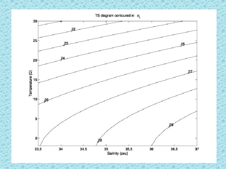
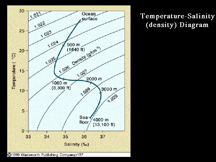
Water density • A function of temperature and salinity • Density = mass/volume • Seawater weighs 2 -3% more than fresh water • Density of seawater is 1. 020 – 1. 030 g/cm 3 (density of fresh water is 1. 000 g/cm 3) • Seawater’s density increases with increasing salinity, increasing pressure and decreasing temperature
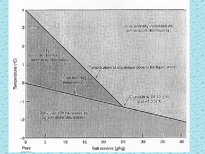

Seawater can have the same density at different temperature and salinity combinations
 relatively")
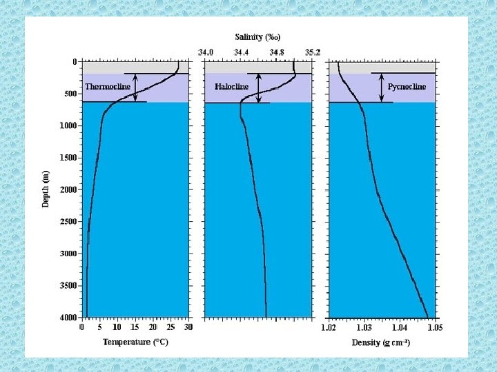
Density zones • Surface – mixed layer – Temperature and salinity (thus density) relatively constant with depth because of wind mixing – Least dense water – Exposed to atmosphere and sunlight – 2% of total ocean volume – Typically 10 - 100 m (book says ~150 m) but ranges from nearly 0 – 1000 m • Pycnocline – Density increases steeply with depth – Separates surface and deep water – 18% of ocean water • Deep zone – Little change in water density with depth
, low-density water at the surface • Rapid")
• In surface, warm (maybe saltier), low-density water at the surface • Rapid density increase within pycnocline mainly due to decrease in temperature (thermocline) • In some regions (e. g. , near rivers) may get a strong pycnocline due to vertical variations in salinity (or a halocline)

Stratification • An assessment of water column stability • Temperature pretty constant in mixed layer • Rapid density increase with depth mainly due to decrease in temperature (thermocline); e. g. , the pycnocline is mainly due to thermocline in the open ocean • At depth is dense, cold, stable water. The bulk of the ocean water is < 1 – 3 o. C bringing the average ocean temperature to 3. 9 o. C

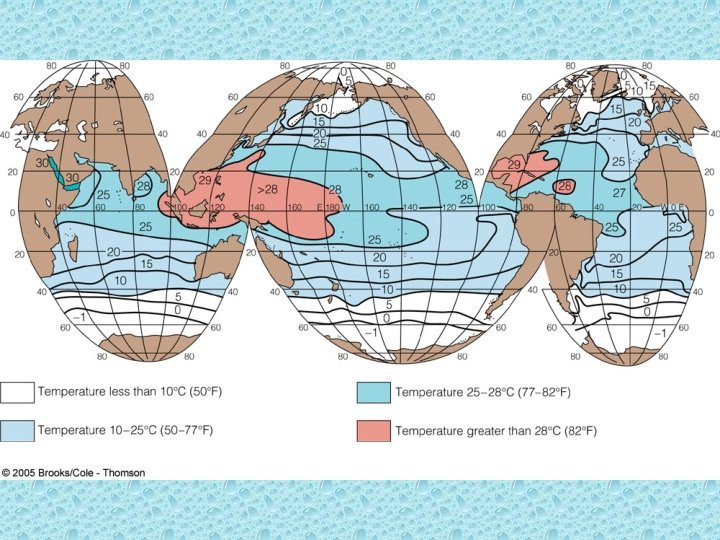
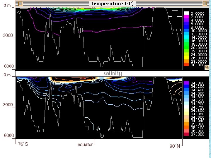
The effect of temperature • Temperature varies with latitude due to differential solar heating (future) • Radiation hits the earth in parallel rays • Incident angle varies with latitude • Energy is spread out over more area • Passes through more atmosphere S • Poles are cooler because they receive lower intensity solar radiation do to angle of incident radiation. N
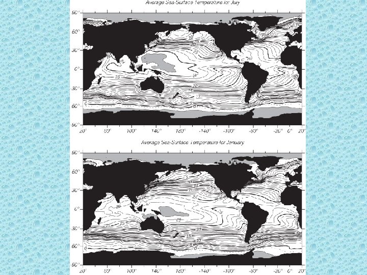

Thermocline • Shape varies depending on latitude or other factors – most pronounced at midand low latitudes • Surface temperature is regulated by sunlight and solar heating • Thermocline varies with season and local conditions (storms, wind, etc)

Tropical Thermocline • Surface layer is thicker in the tropics – Higher sunlight penetration is due to sun angle and fewer suspended particles. • Tropical thermocline is deeper and more pronounced (steeper) • Tropical surface later can warm to ~ 30 o. C • Deep waters still cold

Polar Thermocline • Little solar heat • Often little change in surface temperature (surface can actually be colder than deeper water!) • Often lack a thermocline • If there is a thermocline it is less steep and may be a shallower depth

• Surface temperature varies • Deep water is cold everywhere

Polar Temperate Tropical

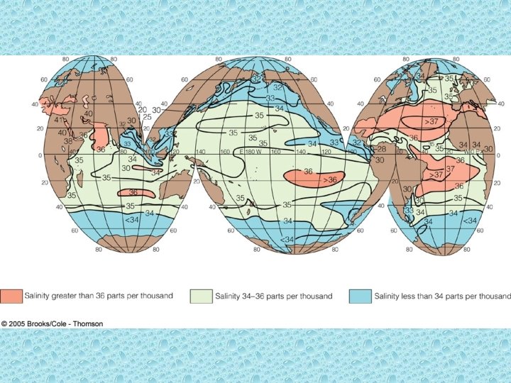
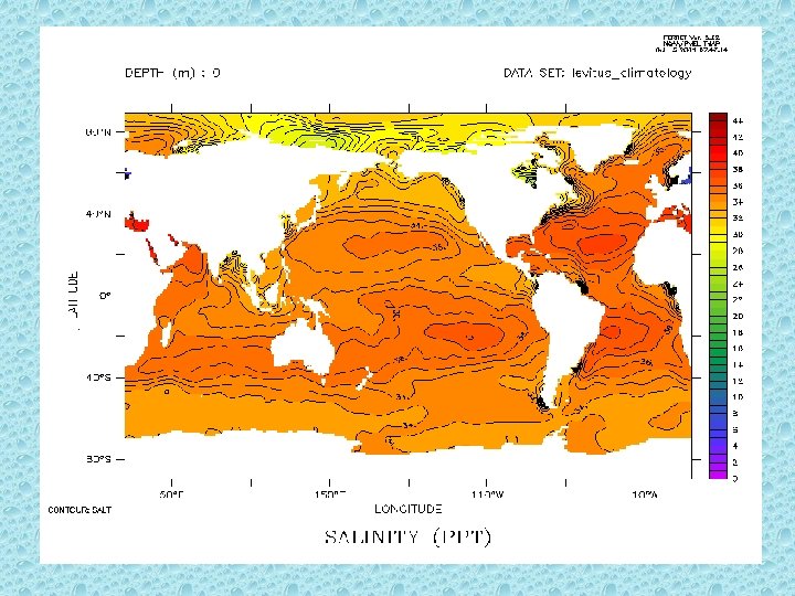
Salinity also varies with latitude • For different reasons than temperature • Global balance of precipitation and evaporation • High salinity where little precipitation • At poles also have seasonal ice formation and melting
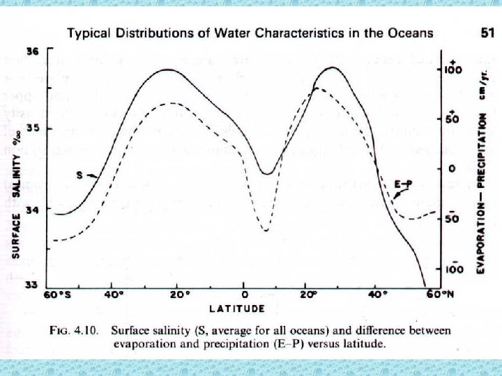

The effect of salinity on density • Low salinity can also contribute to pycnocline (e. g. , rivers) • Also, latitudnally, – Where precipitation >> evaporation, salinity will be low – Where evaporation >> precipitation, salinity will be high • Changes in salinity with depth produce the halocline (zone of rapid salinity increase with depth) • Halocline often coincides with thermocline and together produce pycnocline

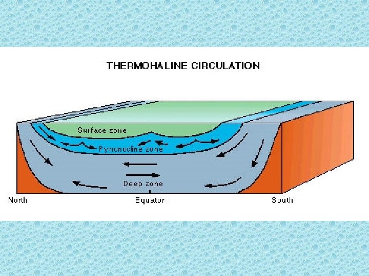
Water masses • We describe “water masses” as discreet parcels of water with characteristic temperature and salinity (therefore density) • Even the densest water mass has origins at the surface (Deep water production in N Atlantic, mid -water production in Mediterranean) • Water masses retain their identity for a long time • Water masses are layered by density and may circulate differently – Surface circulation driven by atmospheric heating and cooling and winds

Density stratification • Vertical movement of water is possible when surface density increases to resemble deep water density • Very stable water column in the tropics driven by temperature (solar heating outweighs storms and horizontal movement) • Water column stability in northern polar regions driven by salinity (high runoff and ice formation) • Southern polar ocean is more weakly stratified and mixes through the circumpolar current (little runoff). Turbulence encourages deep-water upwelling.

Summary - Ocean surface • Temperature shows effects of differential solar radiation with latitude – More variation in temperature in the temperate zone but salinity more stable • Salinity shows ratio of evaporation to precipitation – Evaporation >> precipitation in tropics – Precipitation >> evaporation in temperate and polar zones • Variations in temperature and salinity (and density) confined to surface water.

Take home points • Thermocline, halocline, pycnocline • Solar heating • Effect of ice (freezing and melting), precipitation, evaporation • Relative distribution of temperature and salinity with depth • Relative distribution of temperature and salinity with latitude • Ocean is density stratified
- Slides: 30