Definitions Spatial Reference System SRS Same as Coordinate
 – Same as “Coordinate System” in Arc. Map")

")


![WGS 1984 PRJ File Contents GEOGCS["GCS_WGS_1984", DATUM["D_WGS_1984", SPHEROID["WGS_1984", 6378137. 0, 298. 257223563 ] ],](https://slidetodoc.com/presentation_image_h/e39ecc7a6af85eb56631cfd8c2104321/image-12.jpg "WGS 1984 PRJ File Contents GEOGCS[\"GCS_WGS_1984\", DATUM[\"D_WGS_1984\", SPHEROID[\"WGS_1984\", 6378137. 0, 298. 257223563 ] ],")


![Oregon State Plane North • Continued from previous slide: – – – – PROJECTION["Lambert_Conformal_Conic"],](https://slidetodoc.com/presentation_image_h/e39ecc7a6af85eb56631cfd8c2104321/image-16.jpg "Oregon State Plane North • Continued from previous slide: – – – – PROJECTION[\"Lambert_Conformal_Conic\"],")
![Robinson (world) PROJCS["World_Robinson", GEOGCS["GCS_WGS_1984", …], PROJECTION["Robinson"], PARAMETER["False_Easting", 0. 0], PARAMETER["False_Northing", 0. 0], PARAMETER["Central_Meridian", 0.](https://slidetodoc.com/presentation_image_h/e39ecc7a6af85eb56631cfd8c2104321/image-17.jpg "Robinson (world) PROJCS[\"World_Robinson\", GEOGCS[\"GCS_WGS_1984\", …], PROJECTION[\"Robinson\"], PARAMETER[\"False_Easting\", 0. 0], PARAMETER[\"False_Northing\", 0. 0], PARAMETER[\"Central_Meridian\", 0.")

![UTM, Zone 10 North PROJCS["WGS_1984_UTM_Zone_10 N", GEOGCS["GCS_WGS_1984”, …], PROJECTION["Transverse_Mercator"], PARAMETER["False_Easting", 500000. 0], PARAMETER["False_Northing", 0.](https://slidetodoc.com/presentation_image_h/e39ecc7a6af85eb56631cfd8c2104321/image-19.jpg "UTM, Zone 10 North PROJCS[\"WGS_1984_UTM_Zone_10 N\", GEOGCS[\"GCS_WGS_1984”, …], PROJECTION[\"Transverse_Mercator\"], PARAMETER[\"False_Easting\", 500000. 0], PARAMETER[\"False_Northing\", 0.")


- Slides: 22
Definitions • Spatial Reference System (SRS) – Same as “Coordinate System” in Arc. Map • Esri uses both at “Projection” to refer to an SRS • Geographic Coordinate System (GCS) • Projected Coordinate System (PCS)
Definitions • Datum – shape of the earth – Typically contains a Spheroid • Coordinate System – Cartesian or Rectangular – Spherical (Geographic) • Projection – How to convert 3 D to 2 D – Geographic or Un-projected – UTM – State Plane
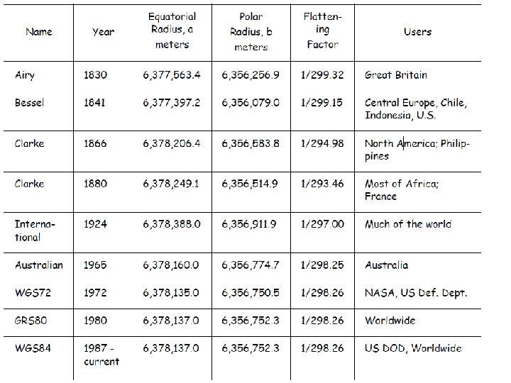
Major Axis Minor Axis Inverse Flattening = Semi-Major Axis/ (Semi-Major Axis – Semi-Minor Axis) Name Semi-Major Axis Inverse Flattening WGS 84 6378137. 0 298. 257223563 WGS 72 6378135. 0 298. 26 NAD 27 6378206. 4 294. 9786982 NAD 83 6378137. 0 298. 257222101
GIS Fundamentals, Paul Bolstad, University of Minnesota
North-South Datum Shift
East-West Datum Shift GIS Fundamentals, Paul Bolstad, University of Minnesota
Arc. GIS Datum Shifts • Picture of Arc. GIS with geographic transform menu
Selecting a Datum Shift • Link Arc. GIS’s website • http: //blogs. esri. com/esri/arcgis/2009/05/ 06/about-geographic-transformationsand-how-to-choose-the-right-one/ • Article with tables to select datum shift for each version of Arc. GIS: – http: //support. esri. com/en/knowledgebase/te charticles/detail/21327 • Jim’s Research Group Website: – http: //seer. science. oregonstate. edu/cwis 438 /Websites/EPSG_Home. php
Arc. GIS PRJ Files • Contain the SRS’s for defining and projecting data • Program Files – Arc. GIS • Desktop 10. 0 – Coordinate Systems » Geographic Coordinate Systems » Projected Coordinate Systems » Vertical Coordinate Systems
Shapefile Properties Dialog
WGS 1984 PRJ File Contents GEOGCS["GCS_WGS_1984", DATUM["D_WGS_1984", SPHEROID["WGS_1984", 6378137. 0, 298. 257223563 ] ], PRIMEM["Greenwich", 0. 0], UNIT["Degree", 0. 0174532925199433], AUTHORITY["EPSG", 4326] ]
Natural Earth: PRJ File • GEOGCS["GCS_WGS_1984", – DATUM["D_WGS_1984", – SPHEROID["WGS_1984", • 6378137. 0, 298. 257223563]], – PRIMEM["Greenwich", 0. 0], – UNIT["Degree", 0. 0174532925199433]] http: //docs. geotools. org/stable/javadocs/org/opengis/referencing/doc-files/WKT. html
Projected Coordinate Systems • Continental – North America • North America Albers Equal Area Conic • North America Lambert Conformal Conic – State Plane • NAD 1927 (US Feet) • NAD 1983 (Meters) – UTM – World (Sphere-based)
Oregon State Plane North • PROJCS["NAD_1927_State. Plane_Oreg on_North_FIPS_3601", – GEOGCS["GCS_North_American_1927", • DATUM["D_North_American_1927", – SPHEROID["Clarke_1866", 6378206. 4, 294. 9786982]], • PRIMEM["Greenwich", 0. 0], • UNIT["Degree", 0. 0174532925199433]], – (continued on next slide)
Oregon State Plane North • Continued from previous slide: – – – – PROJECTION["Lambert_Conformal_Conic"], PARAMETER["False_Easting", 2000000. 0], PARAMETER["False_Northing", 0. 0], PARAMETER["Central_Meridian", -120. 5], PARAMETER["Standard_Parallel_1", 44. 33333334], PARAMETER["Standard_Parallel_2", 46. 0], PARAMETER["Latitude_Of_Origin", 43. 6666666], UNIT["Foot_US", 0. 3048006096012192]]
Robinson (world) PROJCS["World_Robinson", GEOGCS["GCS_WGS_1984", …], PROJECTION["Robinson"], PARAMETER["False_Easting", 0. 0], PARAMETER["False_Northing", 0. 0], PARAMETER["Central_Meridian", 0. 0], UNIT["Meter", 1. 0], AUTHORITY["ESRI", 54030]]
Projected Coordinate Systems • UTM – WGS 1984 • Northern Hemisphere – WGS 1984 UTM Zone 1 N to 60 N • Southern Hemisphere – WGS 1984 UTM Zone 1 S to 60 N – NAD 1983 • NAD 1983 UTM Zone 1 N to 60 N
UTM, Zone 10 North PROJCS["WGS_1984_UTM_Zone_10 N", GEOGCS["GCS_WGS_1984”, …], PROJECTION["Transverse_Mercator"], PARAMETER["False_Easting", 500000. 0], PARAMETER["False_Northing", 0. 0], PARAMETER["Central_Meridian", -123. 0], PARAMETER["Scale_Factor", 0. 9996], PARAMETER["Latitude_Of_Origin", 0. 0], UNIT["Meter", 1. 0], AUTHORITY["EPSG", 32610]]
Raster Properties Dialog
Reference System Standards • European Petroleum Standards Group – EPSG • Well Known Text Form – WKT • Arc “projection” files – PRJ (contains entire SRS) • Proj 4 – Projects and performs datum shifts
Geographic/Datum Transforms • International Association of Oil and Gas Producers: – European Petroleum Survey Group (EPSG) – http: //www. epsg. org/ – 53 Ellipsoids – 630 Datums (Ellipsoid plus prime meridian and units)