Data Sources for GIS in Water Resources by

Data Sources for GIS in Water Resources by Ayse Kilic and Meetpal Kukal with materials from David R. Maidment, and David G. Tarboton GIS in Water Resources Fall 2015

Learning Objectives • The hierarchical system of watersheds and basins in US • Where to obtain data and maps for National/State/Global Data repositories • USGS National Water Information System – Surface water systems – National Hydrography Dataset and – Watershed Boundary Dataset

• Following slides shows links for National/State/Global Data repositories for Environmental and natural resources data
 is a one Stop Source for environmental and natural")
The Geospatial Data Gateway (GDG) is a one Stop Source for environmental and natural resources data http: //datagateway. nrcs. usda. gov/

http: //datagateway. nrcs. usda. gov/

By USGS http: //viewer. nationalmap. gov/viewer/

USGS GIS data for Water http: //water. usgs. gov/maps. html Water's mission is to collect and disseminate reliable, impartial, and timely information that is needed to understand the Nation's water resources.
 using a nationwide")
WATERSHEDS • Watersheds are delineated by USGS (United States Geological Survey) using a nationwide system based on surface hydrologic features. • Hydrologic Unit Codes (HUC) • HUCs are Building blocks of water studies. They are important for estimating water supply, water quality, and runoff. • The HUC can range from 2 to 16 digits long - More numbers means its the address of a smaller watershed. • This system divides the country into 21 regions, 222 subregions, 352 accounting units, and 2, 262 cataloguing units.

Represents the drainage network with features such as rivers, streams, canals, lakes, ponds, coastline, dams, and stream gages River networks for 8 -digit HUC watersheds http: //nhd. usgs. gov/

Water Resources Regions of the US There are 18 water resources regions in the Continental United States regions
 HUC - 2 REGION: Major land areas. The lower")
Hydrologic Unit Codes - (HUC) HUC - 2 REGION: Major land areas. The lower 48 states have 18 total, 1 additional each for Alaska, Hawaii, and the Caribbean. ( 21 Total in US) Called 1 st Level - or Watershed 1 st Level HUC - 4 SUBREGION: Each Region has from 3 to 30 Subregions. The Missouri River Region has 30 Subregions. The lower 48 states have 204 (222 Total in US). Called 2 nd Level HUC - 6 BASIN: Accounting Unit. ( 352 Total in US). Called 3 Rd Level HUC - 8 SUBBASIN: Cataloging Unit. The smallest is 448 K Acres (700 mi²). Most are much larger. National HQ compilations have this as the smallest size unit. ( 2, 149 Total in US) Called 4 th Level. Called “watersheds”. HUC - 10 WATERSHED: Typically from 40 to 250 K Acres (62 to 390 mi²) Called 5 th Level or Watershed 5 th Level. - 12 SUBWATERSHED: Typically from 10 to 40 K Acres (15 to 62 mi²) Called 6 th HUC Level or Watershed 6 th Level.

Watersheds of the US Every watershed has a unique number!!! An eight-digit code uniquely identifies each of the four levels of classification: 8 -digit HUC watersheds Hydrologic Unit Code 11130204: 11 -Region 1113 - The subregion 111303 - The accounting Unit (basin) 11130302 - The cataloging unit (subbasin) With a eight digit HUC number, we can identify a subbasin in western Oklahoma
")
Watershed Hierarchy Each hydrologic unit is identified by a unique hydrologic unit code (HUC) consisting of two to eight digits based on the four levels of classification in the hydrologic unit system. Digit # 2 4 6 8 HUC 10 12 NHDPlus Available In Progress

HUC 2: REGIONS The first level of classification divides the Nation into 21 major geographic areas, or regions. These regions are the “big boys” of watersheds. These are called HUC 2’s Region 01 New England Region 02 Mid-Atlantic Region 03 South Atlantic-Gulf Region 04 Great Lakes Region 05 Ohio Region 06 Tennessee Region 07 Upper Mississippi Region 08 Lower Mississippi Region 09 Souris-Red-Rainy Region 10 Missouri Region 11 Arkansas-White-Red Region 12 Texas-Gulf Region 13 Rio Grande Region 14 Upper Colorado Region 15 Lower Colorado Region 16 Great Basin Region 17 Pacific Northwest Region 18 California Region 19 Alaska (Old numbering system) Region 20 Hawaii Region 21 Caribbean

HUC 4: SUBREGION Each Region has from 3 to 30 Subregions. North Platte: 1018 South Platte 1019 Platte River: 1020 The Missouri River Region has 30 Subregions
 North Platte River Subregion South Platte River")
HUC 6 - BASIN (THE ACCOUNTING UNIT) North Platte River Subregion South Platte River Subregion The Platte River Subregion (1020) has two basins 102001 - Middle Platte and 102002 - Lower Platte
 The Middle Platte basin has three Subbasins")
HUC 8 - SUBBASIN (THE CATALOGING UNIT) The Middle Platte basin has three Subbasins 10200101: Middle Platte–Buffalo 10200102: Wood 10200103: Prairie The Lower Platte basin has three Subbasins 10200201: Lower Platte–Shell 10200202: Lower Platte 10200203: Salt

HUC 8 - SUBBASIN (THE CATALOGING UNIT Hydrologic Unit Code Watersheds ~ 2000 HUC 8 (subbasin) for US, about the size of counties This is what the US looks like in terms of eight digit HUC 8
 ftp: //ftp. ftw. nrcs. usda. gov/wbd/WBD_Latest_Version_March 2014/ • National Program")
Watershed Boundary Dataset (WBD) ftp: //ftp. ftw. nrcs. usda. gov/wbd/WBD_Latest_Version_March 2014/ • National Program by USGS and USDA (NRCS- Natural Resources Conservation Service) • It gives us boundaries for 10 - and 12 - digit watersheds • First cut on the boundary was by automated delineation from NED (National Elevation Dataset) • Hand checked and edited 10 -digit watersheds

Watershed Boundary Data. Set http: //www. nrcs. usda. gov/wps/portal/nrcs/main/national/watersheds/dataset/ You can download watershed boundaries for All HUC levels of watersheds
 for Nebraska 2990 HUC 12 watersheds of average area")
Watershed Boundary Dataset (HUC 12) for Nebraska 2990 HUC 12 watersheds of average area 39. 3 square miles HUC 12: HUC 8 ~ 40: 1 watersheds
 for Nebraska 71 HUC-8 watersheds of average area 1654")
Watershed Boundary Dataset (HUC 8) for Nebraska 71 HUC-8 watersheds of average area 1654 square miles
 • • Hydrologic ordering of reaches so")
EPA River Reach File 1 (RF 1) • • Hydrologic ordering of reaches so that larger rivers and segment are accurately defined along with connectedness and flow direction EPA uses river reaches to assign water quality information Provides a unique identifier for each surface water feature, i. e. , reach codes. River Reach data for streams, wide rivers, reservoirs, lakes, miscellaneous hydrographic features, and the coastal shorelines for the Atlantic Ocean and Gulf of Mexico (EPA: Environmental Protection Agency)
 and GIS Data")
EPA BASINS Model (Better Assessment Science Integrating point & Non-point Sources) and GIS Data State and Local Data Cartographic Monitoring Tools Target Assess DM Models HSPF - NPSM QUAL 2 E Assessment TOXIROUTE Loadings Data Mining Reporting Decisions Watershed Management. TMDL Post-Processors . Source Water Protection. Stormwater

http: //nhd. usgs. gov/ Represents the Drainage Network of the United States, with features such as rivers, streams, canals, lakes, ponds, coastline, dams, and stream gages River networks for three 8 -digit HUC watersheds Notice that the only difference in the 8 -digit HUC number is in the last two digits. All three subbasins are in basin 03.

http: //nhd. usgs. gov/wbd. html • http: //viewer. nationalmap. gov/viewer/nhd. html? p=nhd
 • Surface water of the United States using common")
The National Hydrography Dataset (NHD) • Surface water of the United States using common features such as lakes, ponds, streams, rivers, canals, stream gages, and dams. • Features: • • • Polygons are used to represent area features such as lakes, ponds, and rivers; Lines are used to represent linear features such as streams and smaller rivers; Points are used to represent point features such as stream gages and dams. • Lines also are used to show the water flow through area features such as the flow of water through a lake. • The combination of lines is used to create a network of water and transported material flow to allow users of the data to trace movement in downstream and upstream directions. • The Watershed Boundary Dataset (WBD) is a companion dataset to the NHD • WBD defines the perimeter of drainage areas formed by the terrain and other landscape characteristics.

Shows some of the terms used and whether they are points, lines, or polygons (areas)

Lower West Fork, Trinity River Basin, TX HUC = 12030102 Example of the two dimensional spatial information on water courses

NHD River Reaches • Reach "a segment of surface water having a unique identifier. • Provides a common coding scheme for identifying river reaches (including all or portions of rivers, streams, and ditches, and flowpaths through lakes and wetlands) and full watercourses There are 412 River Reaches In Upper West Fork of Trinity Basin
 Used for river address locations Hydrologic Cataloging Unit Code")
River Reach Codes (6 digit) Used for river address locations Hydrologic Cataloging Unit Code + Reach or segment code Reach. Code = 12030102000151 Reach. Code = 12030102000005 HUC# Segment# Location 0. 392 on Reach 12030102000005 We can have many, many segments on a single HUC-8 subbasin

NHDPlus Reach Attributes • Slope • Elevation • Mean annual flow – Corresponding velocity • Drainage area • % of upstream drainage area in different land uses • Stream order • NHDPlus is enhanced NHD

http: //www. horizon-systems. com/nhdplus/
, the")
NHDPlus Incorporates many of the best features of the National Hydrography Dataset (NHD), the National Elevation Dataset (NED), and the National Watershed Boundary Dataset (WBD). http: //www. horizon-systems. com/nhdplus/data. php

NHDPlus Schema • The NHDPlus database tables are stitched together by the relationship classes. • Enables quick and easy access to information pertaining to a particular feature such as an individual streamlines catchments

NHDPlus for a Portion of Oregon http: //www. horizon-systems. com/nhdplus/

NHDPlus Reach Catchments ~ 3 km 2 Average reach length = 2 km 2. 3 million reaches for continental US About 1000 reach catchments in each 8 -digit HUC

NHDPlus Reach Attributes • Slope • Elevation • Mean annual flow – Corresponding velocity • Drainage area • % of upstream drainage area in different land uses • Stream order

National Elevation Dataset http: //ned. usgs. gov/ • Digital Elevation Model with 1 arcsecond (30 m) cells • Seamless in 1° blocks for the United States • 10 billion data • Derived from USGS 1: 24, 000 quadrangle sheets Get the data: http: //nationalmap. gov/viewer. html

Measuring in Arc-Seconds • Some USGS DEM data is stored in a block that utilizes three, five, or 30 arcseconds of longitude and latitude to register cell values. • The geographic reference system treats the globe as if it were a sphere divided into 360 equal parts called degrees. • Each degree is subdivided into 60 minutes. • Each minute is composed of 60 seconds. • An arc-second represents the distance of latitude or longitude traversed on the earth's surface while traveling one second (1/3600 th of a degree). • At the equator, an arc-second of longitude approximately equals an arc-second of latitude, which is 1/60 th of a nautical mile (30. 87 meters). • Arc-seconds of latitude remain nearly constant, while arc-seconds of longitude decrease as one moves toward the earth's poles. • At 49 degrees north latitude, along the northern boundary of the Concrete sheet, an arc-second of longitude equals 30. 87 meters * 0. 6561 (cos 49°) or 20. 250 meters.

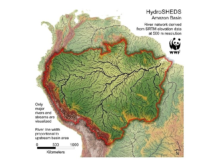
Hydro. Sheds derived from SRTM http: //hydrosheds. cr. usgs. gov/

Drainage in North America Hydro 1 K is derived from GTOPO 30 using raster GIS analysis http: //eros. usgs. gov/#/Find_Data/Products_and_Data_Available/gtopo 30/hydro

http: //www. nationalatlas. gov/atlasftp. html

http: //water. weather. gov/ahps/

National Water Information System http: //waterdata. usgs. gov/usa/nwis/ Web access to USGS water resources data in real time

http: //waterwatch. usgs. gov/

Web access to USGS water resources data in real time http: //waterdata. usgs. gov/nwis/rt

USGS National Water Information System. • Real-time and Historic Data – – Streamflow and stage Groundwater levels Water Quality Site information • Tabular or Graphical Format
- Slides: 49