Data Gathering over Underwater Wireless Sensor Networks Presented


- Slides: 11
“Data Gathering over Underwater Wireless Sensor Networks” Presented by Ahmed Ezzat Abd-El. Gawad
The Main Idea • The Main idea is collecting data from scattered static nodes using Autonomous Vehicle underwater. • Node’s Specifications : Underwater Node “the Aquafleck” – wireless sensor device developed by the CSIRO called a Fleck – 8 -bit CPU – 512 kbytes of flash memory – High power LED and a sensitive matched photodiode supports maximum data rate of 320 kbits/s at a maximum range of 2 m (8 m when augmented with a lens). – Pressure sensor & temperature sensor – Three C-cells that can power the node for several days “continuous power” , several months on “power saving”
The Main Idea Cont. • Autonomous Vehicle’s Specification : “Starbug AUV” – PC/104 computer stack – Crusoe processor – Linux performs vehicle control as well as all image processing – Stereo camera pairs for vision-based motion estimation system – Maximum forward thrust 20 N – Six thrusters providing forward, lateral and vertical translations, yaw, roll and pitch rotations – communication Aquafleck node – CAN Protocol
The Main Achievements • Main Work was divided upon two axes –Communication and networking –Navigating & Locating nodes The Main Algorithm of Data muling proceeds in several stages as follows: 1) Compute a route that goes through all the nodes. 2) Select the next node to be visited. 3) Travel to the approximate location of the selected node. 4) Locate the node visually and establish communications. 5) Hover while uploading the data. 6) If not the last node, go to (2).
Navigating & Locating nodes • If the next node is nearby, the robot navigates using current location estimate and visual odometry, magnetic compass. • If the node is far, the robot performs a GPS based transect. periodically surfaces to obtain a GPS fix and correct trajectory. If within a specified radius of the desired node • Travels on the surface using GPS to locate itself over the node. • quick dive to the bottom • The robot will reset its position estimate when it finds (and identifies) the node so error accumulate only along each segment of the tour.
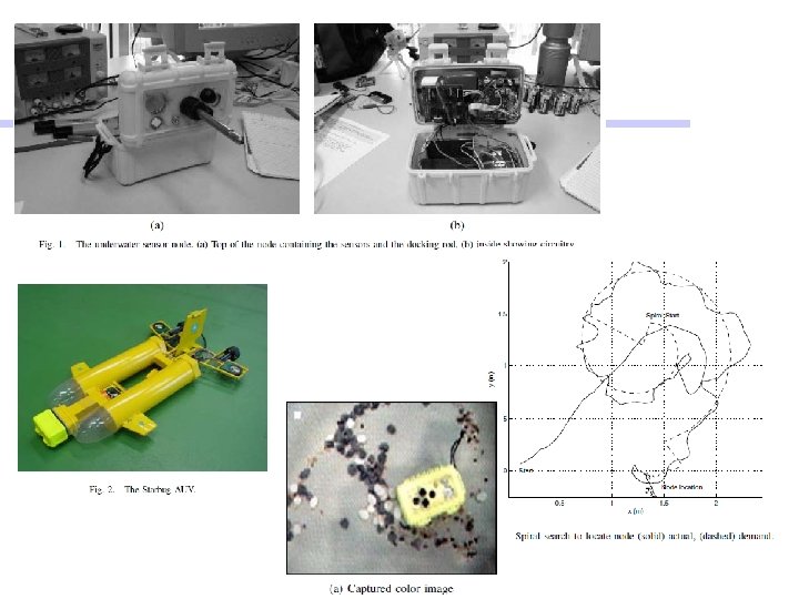
Navigating & Locating nodes Cont. • Spiral Search: – If the robot does not initially locate a node when arriving at where it thinks one should be, Spiral search is initiated. – Robot navigates along a spiral, centered around the best approximate position of the Aquafleck using visual odometry to keep track of the position. – Constant pitch spiral whose centre is located at (x 0, y 0) was implemented such that the desired position at time t is: (x(t), y(t)) = x 0+t cos(w t), y 0+t sin(w t). where the constant w determines the pitch.
Communication and networking • Once the Node is identified, a protocol is executed to establish communication for data transmission. • First enquires about the amount of data to upload from the node. • Requests data in 239 byte segments. • If segment is not received within a specified period, asks for it again. • Communication optical signaling at a data rate of 320 kbits/sec • Stateless protocol & no acknowledgements. • The robot can request: – The node ID, the node’s capabilities (camera, pressure, temperature), – The amount of logged data stored in flash memory, and a – Specific part of the data (specified by address and length).
The Challenges • Identifying Starting Position. • Underwater navigation not very accurate. • Water Speed, Tides, Visual Obstacles. • Identifying Nodes visually.
Innovation • Hybrid GPS based and Visual navigation. • Light Based data transfer. • Spiral Search. • Object Tracking Algorithm.
References • Data Muling over Underwater Wireless Sensor Networks using an Autonomous Underwater Vehicle