
DASFAA 2020 Discovering Realtime Reachable Area using Trajectory

DASFAA 2020 Discovering Real-time Reachable Area using Trajectory Connections Ruiyuan Li, Jie Bao, Huajun He, Sijie Ruan, Tianfu He, Liang Hong, Zhongyuan Jiang, Yu Zheng System Demo About Me
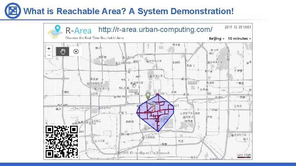
What is Reachable Area? A System Demonstration! http: //r-area. urban-computing. com/
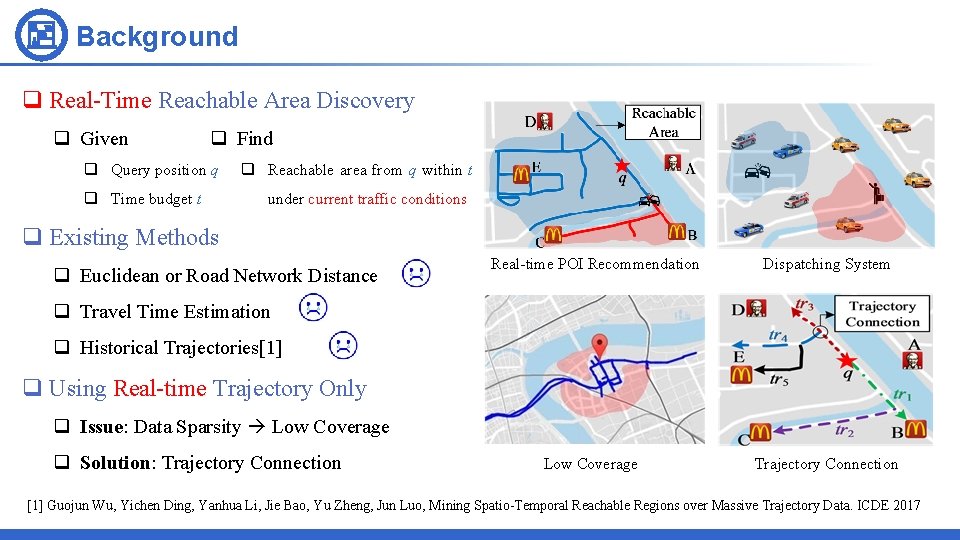
Background q Real-Time Reachable Area Discovery q Given q Find q Query position q q Time budget t q Reachable area from q within t under current traffic conditions q Existing Methods q Euclidean or Road Network Distance Real-time POI Recommendation Dispatching System q Travel Time Estimation q Historical Trajectories[1] q Using Real-time Trajectory Only q Issue: Data Sparsity Low Coverage q Solution: Trajectory Connection Low Coverage Trajectory Connection [1] Guojun Wu, Yichen Ding, Yanhua Li, Jie Bao, Yu Zheng, Jun Luo, Mining Spatio-Temporal Reachable Regions over Massive Trajectory Data. ICDE 2017
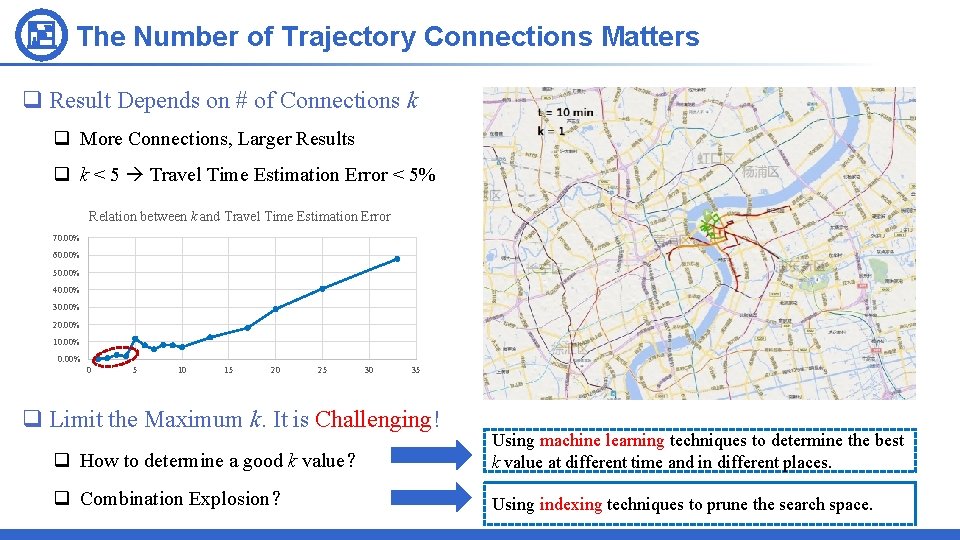
The Number of Trajectory Connections Matters q Result Depends on # of Connections k q More Connections, Larger Results q k < 5 Travel Time Estimation Error < 5% Relation between k and Travel Time Estimation Error 70. 00% 60. 00% 50. 00% 40. 00% 30. 00% 20. 00% 10. 00% 0 5 10 15 20 25 30 35 q Limit the Maximum k. It is Challenging! q How to determine a good k value? Using machine learning techniques to determine the best k value at different time and in different places. q Combination Explosion? Using indexing techniques to prune the search space.
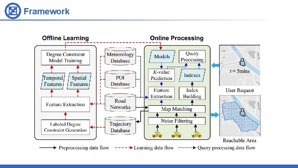
Framework
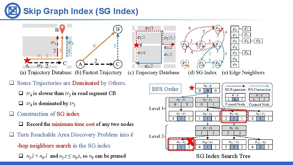
Skip Graph Index (SG Index) q Some Trajectories are Dominated by Others. q tr 4 is slower than tr 3 in road segment CB BFS Order q tr 4 is dominated by tr 3 q Construction of SG index q Record the minimum time cost of any two nodes q Turn Reachable Area Discovery Problem into k -hop neighbors search in the SG index q n 5. l < n 9. l and n 5. t ≤ n 9. t, so n 9 can be pruned SG Index Search Tree
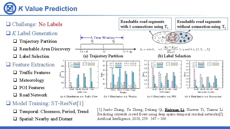
K Value Prediction Reachable road segments with k connections using T 1 q Challenge: No Labels Reachable road segments without connection using T 2 q K Label Generation q Trajectory Partition q Reachable Area Discovery q Label Selection (a) Trajectory Partition (b) Label Selection q Feature Extraction q Traffic Features q Meteorology q POI Features q Road Network q Model Training: ST-Res. Net[1] q Temporal: Closeness, Period, Trend q Spatial: Nearby and Distant [1] Junbo Zhang, Yu Zheng, Dekang Qi, Ruiyuan Li, Xiuwen Yi, Tianrui Li. Predicting citywide crowd flows using deep spatio-temporal residual networks[J]. Artificial Intelligence, 2018, 259 : 147 – 166.
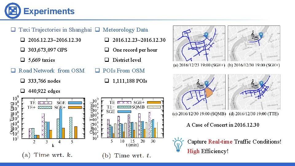
Experiments q Taxi Trajectories in Shanghai q Meteorology Data q 2016. 12. 23~2016. 12. 30 q 303, 673, 097 GPS q One record per hour q 5, 669 taxies q District level q Road Network from OSM q 333, 766 nodes q POIs From OSM q 1, 111, 188 POIs q 440, 922 edges A Case of Concert in 2016. 12. 30 Capture Real-time Traffic Conditions! High Efficiency!
Conclusion q We provide the first attempt to discover real-time reachable areas with trajectory connections. q We set a good example for the combination of indexing techniques and machine learning techniques. q Proposed indexing techniques guarantee the high efficiency! q Machine learning techniques help us find a good k value to capture the real-time traffic conditions! q System demo is available at http: //r-area. urban-computing. com/.

Discovering Real-time Reachable Area using Trajectory Connections Thanks! Project Homepage R-Area Contact Me liruiyuan@whu. edu. cn
- Slides: 10