DAMS Dams and reservoirs literature Bell F G

DAMS

Dams and reservoirs - literature • Bell F. G. , Engineering geology and geotechnics

Dams Dam is a solid barrier constructed at a suitable location across a river valley to store flowing water. • Storage of water is utilized for following objectives: • • • Hydropower Irrigation Water for domestic consumption Drought and flood control For navigational facilities Other additional utilization is to develop fisheries
 MWL Max. level NWL")
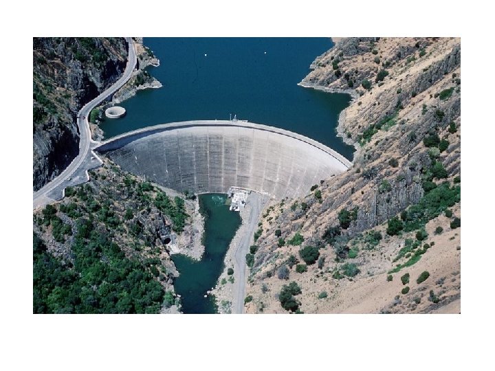
Structure of Dam Crest Upstream Down stream Spillway (inside dam) MWL Max. level NWL Normal water level Free board Sluice way Gallery Heel Toe

Parts of a dam • Heel: contact with the ground on the upstream side • Toe: contact on the downstream side • Abutment: Sides of the valley on which the structure of the dam rest • Galleries: small rooms like structure left within the dam for checking operations. • Diversion tunnel: Tunnels are constructed for diverting water before the construction of dam. This helps in keeping the river bed dry. • Spillways: It is the arrangement near the top to release the excess water of the reservoir to downstream side • Sluice way: An opening in the dam near the ground level, which is used to clear the silt accumulation in the reservoir side.

Dams: forces applied • Vertical static forces • Lateral force applied by water body • Dynamic forces – wave action – overflow of water (controlled by spillway channels) – earthquakes and tremors – ice/freezing

CLASSIFICATION OF DAMS
 dam 2. Small dam")
ACCORDING to the SIZE of the DAM 1. Large (Big) dam 2. Small dam • International Commision on Large Dams, (ICOLD) assumes a dam as big when its height is bigger than 15 m. • If the height of the dam is between 10 m and 15 m and matches the following criteria, then ICOLD accepts the dam as big: • • If the crest length is bigger than 500 m If the reservoir capacity is larger than 1 million m 3 If the flood discharge is more than 2000 m 3/s If there are some difficulties in the construction of foundation

ACCORDING to the STATICAL DESIGN of DAM BODY • Gravity Dams • Arch Dams • Butress Dams • Embankment Dams • Composite Dams

Dams: types • Gravity dam: rigid monolithic structure – Trapezoidal cross section – Minimal differential movement tolerated – Dispersed moderate stress on valley floor and walls • Arch dam: high strength concrete wall – – Convex faces upstream Thin walled structure Relatively flexible Huge stresses imposed on valley walls and floor • Earth dams: bank or earth or rock with impermeable core – Core of clay or concrete, extended below ground – Sand or gravel drains built to cut fluid pressure – Low stress applied to valley floor and walls

TYPES OF DAMS • Gravity Dams: Reservoir Force • These dams are heavy and massive wall-like structures of concrete in which the whole weight acts vertically downwards As the entire load is transmitted on the small area of foundation, such dams are constructed where rocks are competent and stable.

• • Bhakra Dam is the highest Concrete Gravity dam in Asia and Second Highest in the world. • Bhakra Dam is across river Sutlej in Himachal Pradesh • The construction of this project was started in the year 1948 and was completed in 1963. It is 740 ft. high above the deepest foundation as straight concrete dam being more than three times the height of Qutab Minar. Length at top 518. 16 m (1700 feet); Width at base 190. 5 m (625 feet), and at the top is 9. 14 m (30 feet) Bhakra Dam is the highest Concrete Gravity dam in Asia and Second Highest in the world.

n Buttress Dam: Buttress Dams use multiple reinforced columns to support a dam that has a relatively thin structure. Because of this, these dams often use half as much concrete as gravity dams • Buttress Dam – Is a gravity dam reinforced by structural supports • Buttress - a support that transmits a force from a roof or wall to another supporting structure This type of structure can be considered even if the foundation rocks are little weaker

n Arch Dams: Arch Dams utilize the strength of an arch to displace the load of water behind it onto the rock walls that it is built into. • These type of dams are concrete or masonry dams which are curved or convex upstream in plan • This shape helps to transmit the major part of the water load to the abutments • Arch dams are built across narrow, deep river gorges, but now in recent years they have been considered even for little wider valleys.

Earth Dams: • They are trapezoidal in shape • Earth dams are constructed where the foundation or the underlying material or rocks are weak to support the masonry dam or where the suitable competent rocks are at greater depth. • Earthen dams are relatively smaller in height and broad at the base • They are mainly built with clay, sand gravel, hence they are also known as Earth fill dam or Rock fill dam
 • They are mostly composed of")
EMBANKMENT DAMS (Rock Fill or Earth Fill Dams) • They are mostly composed of natural materials such as, clay, sand, gravel etc. . . • Impervious core is placed in the middle of the embankment body • Generally riprap is used to control erosion

COMPOSITE DAMS • Composite dams are combinations of one or more dam types. Most often a large section of a dam will be either an embankment or gravity dam, with the section responsible for power generation being a buttress or arch. Gravity & Rock Fill

Dams and reservoirs Reservoirs • Site selection • Leakage from reservoirs • Sedimentation • Stability: effect of raised WT Dams • Types • Forces on a dam • Geology and dam sites • Rock types and dams • Dams on soils • Ground improvement

ENGINEERING GEOLOGICAL STUDIES for DAM CONSTRUCTION

RECONNAISSANCE STUDY 1. 2. 3. 4. 5. 6. 7. Evaluation of the data having at archives Field investigation for limited time (Reconnaissance Study) Some maps in small scale, for example 1/25. 000 or 1/50. 000 Some hydraulic data about a. Basin b. Precipitation area c. Runoff, maximum discharge Some approach to the reservoir area, dam site and type of dam and height of dam. . . etc Photogeological studies A preliminary report

PRELIMINARY STUDIES at the RESERVOIR AREA and DAM SITE 1. 2. 3. 4. 5. Dam site investigations 1. Location of dam axis 2. Location of diversion tunnel 3. Location of spillway 4. Location of powerhouse. . . etc Geological studies Geophysical surveying Underground investigations 1. Boreholes 2. Investigation galleries 3. Pitholes Surveying for materials 1. Field surveying 2. Laboratory tests

6. 7. 8. 9. 10. 11. Slope stability investigations Earthquake hazard & risk analysis Environmental studies Leakage possibilities from reservoir area Leakage possibilities from dam site Erosion, sedimentation & siltation

DETAILED INVESTIGATION at DAM SITE 1. Topographic surveyings 2. Geological mappings 3. Underground explorations Boreholes, adits. . etc 4. Hydrogeological studies 5. Slope stability analysis

FACTORS AFFECTING to the PLACE of the DAM AXIS • • • Topography Geology Materials Spillway location availability Derivation Sediments in the flowing water Water quality Expropriation costs Earthquake possibility Downstream water rights

Site Selection – Geological Consideration • • Narrow valley Bed rock at shallow depth Competent rock to offer stable foundation Proper Geol structure

structure • Horizontal strata -- desirable – load of dam acts perpen to strata. • Alternate competent (qtzite) and incomp (shale) not desirable • Beds with gentle upstream dip = ideal, resultant force acts perpen / oblique to bedding plane, percolation of water directed upstream towards res

structure • Beds with gentle downstream dip = undesirable • WHY?

Reservoirs: purpose • Water storage • Flood prevention • Power

Reservoirs: site selection • Hydrological considerations • Fundamental controls – topography – climate – geology Water added Water subtracted Rainfall in river basin Infiltration Evaporation Transpiration Net amount of water available for storage Runoff

Reservoirs: leakage Water added Rainfall in river basin - Water subtracted - Leakage from reservoir Infiltration Evaporation Transpiration Net amount of water available for storage Runoff 1. Dam bypass 2. Water table effects

Reservoirs: water table leakage-1 lan ds urf wat er ta ac e before water table divide ble Bedrock with a water table and finite permeability river new water table Leakage to next valley reservoir after

Reservoirs: water table leakage-2 Water table in aquifer La nd su rf High permeability layer ac e before Bedrock with low permeability: aquiclude river Modified water table in aquifer reservoir High permeability layer Leakage to next valley after

Most Important • • River is Effluent or Influent = river feeds the GW Effluent = river is fed by GW Influent river = percolation will occur

Silting problem • Measures : 1. Terracing of slope and construction of retaining wall 2. Check Dam settling basins 3. Diversion of sed-loaded water
- Slides: 35