COOPERATIVE LOCALIZATION AND MAPPING OF AUTONOMOUS ROBOTS Principle

CO-OPERATIVE LOCALIZATION AND MAPPING OF AUTONOMOUS ROBOTS Principle Investigator: Lynton Dicks Supervisor: Karen Bradshaw

PRESENTATION OVERVIEW • Introduction • SLAM • CLAM • History and Background • Hardware • Localization Algorithms • Map Merging • Project Implementation
 • Co-operative Localization and Mapping (CLAM) •")
INTRODUCTION • Simultaneous Localization and Mapping (SLAM) • Co-operative Localization and Mapping (CLAM) • Well researched for use on a single robot • Relatively new field • Benefits: • Uses: • Google Autonomous Vehicles • Navigate and map unreachable areas • Military Reconnaissance • Team work saves time • Improved Accuracy
 Pose Tracking Landmark")
SIMULTANEOUS LOCALIZATION AND MAPPING SLAM State Update Landmark Tracking (Dead reckoning) Pose Tracking Landmark Extraction Odometry Data Association

SLAM FRAMEWORK OVERVIEW

COOPERATIVE LOCALIZATION AND MAPPING • Each robots role • Master-slave • Independent Entities • Centralization / Convergence • Aggregation • Communication methods

HISTORY AND BACKGROUND Autonomous Robotic Programming Framework – Leslie Luyt 2009 • • • Generic Programming Framework to combine standard robotic operations with AI Abstracts away the details of interfacing and controlling robots Easy to implement new robot hardware classes to allow the framework to work with new hardware A Robotic Framework for use in Simultaneous Localization and Mapping Algorithms – Shaun Egan 2010 • Generic Framework for both online and offline SLAM • Implemented SLAM for use with one robot

HARDWARE – FISCHERTECHNIK ROBOT • Two Encoder Motors • Two Ultrasonic Sensors • A Bluetooth Controller – 10 m range, ability to keep several connections alive at the same time

HARDWARE: ADDONS Motor Encoders Ultrasonic Sensors

TRIANGULAR BASED FUSION
 • General parameter estimation approach designed to cope with a")
RANDOM SAMPLE CONSENSUS (RANSAC) • General parameter estimation approach designed to cope with a large proportion of outliers in the input data. • Resampling technique that generates candidate solutions by using the minimum number of observations required to estimate the underlying model parameters. • I will be using the least-squares regression model as the underlying model • RANSAC uses the smallest set possible and proceeds to enlarge this set with consistent data points • Unlike conventional sampling techniques that use as much of the data as possible to obtain an initial solution and prune outliers

EXAMPLE RANGE SCAN

LEAST SQUARES APPROXIMATION

RANSAC LEAST SQUARES APPROXIMATION

LOCALIZATION ALGORITHMS • Assumptions: • Unique Landmark Associations and adequately spaced landmarks • Time between observations • Static Environment • One robot will be used to avoid dealing with robot detection • The Algorithms • Extended Kalman Filter • Monte Carlo Particle Filter

MAP BUILDING • Occupancy Grid Maps • Topological Maps Robots assumed to have compass to aid with map orientation!

GRID MAPS

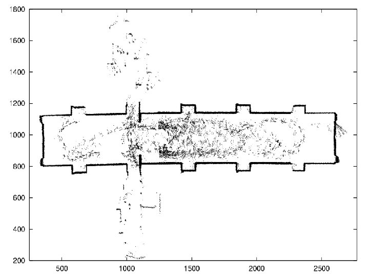
GRID MAP DATA POINTS

OCCUPANCY GRID MAPS

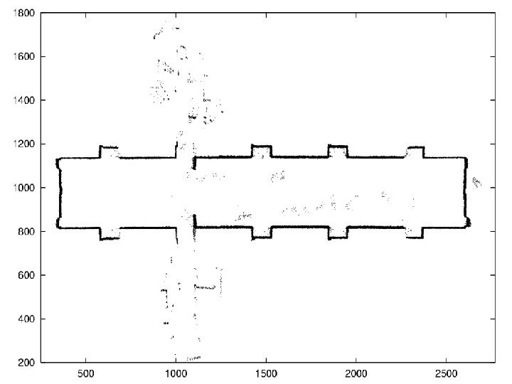
GRID MAP DATA POINTS WITH RANSAC

RANSAC OCCUPANCY GRID MAP
 through")
MAP MERGING • Merge maps with observed robot • Maps are transformed (translated) through merging algorithm • Merging maps of populated environments by keeping track of moving objects
 • Database. Utils (Using sqlite 3)")
PROJECT IMPLEMENTATION • XBox. Utils (Using pygame, zmq) • Database. Utils (Using sqlite 3) • Ransac. Utils • Map. Build. Utils • Map. Merge. Utils

- Slides: 26