CONVECTION INITIATED OVER OCEANS CONVECTION INITIATED OVER OCEANS


- Slides: 34

CONVECTION INITIATED OVER OCEANS

CONVECTION INITIATED OVER OCEANS Convection processes such as storms, . cyclones and. tornados are the. primary means of effectively pumping. heat out of the ocean, into the Atmosphere In mid-latitudes, convection over the sea is most frequently observed in the winter season when cold polar air behind a mid-latitude depression moves over a relatively warm ocean. The warming influence of the ocean surface is the principal mechanism for destabilizing the polar air.

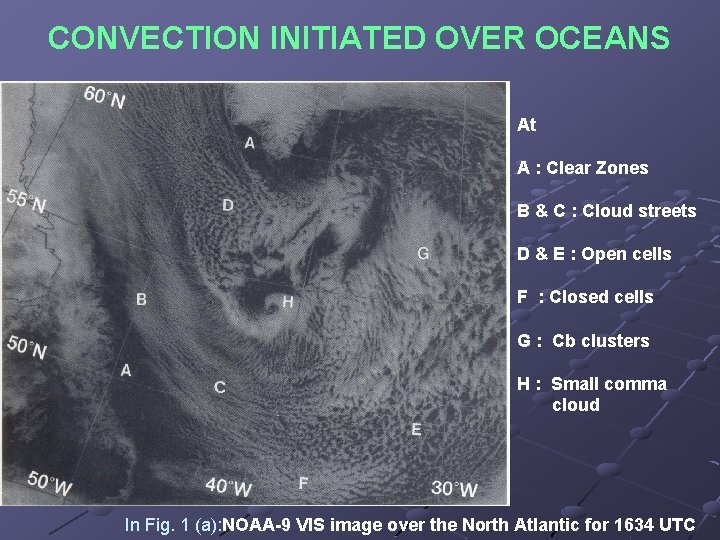
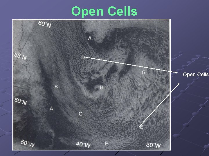
CONVECTION INITIATED OVER OCEANS At A : Clear Zones B & C : Cloud streets D & E : Open cells F : Closed cells G : Cb clusters H : Small comma cloud In Fig. 1 (a): NOAA 9 VIS image over the North Atlantic for 1634 UTC

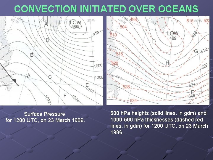
CONVECTION INITIATED OVER OCEANS Surface Pressure for 1200 UTC, on 23 March 1986. 500 h. Pa heights (solid lines, in gdm) and 1000 500 h. Pa thicknesses (dashed red lines, in gdm) for 1200 UTC, on 23 March 1986.

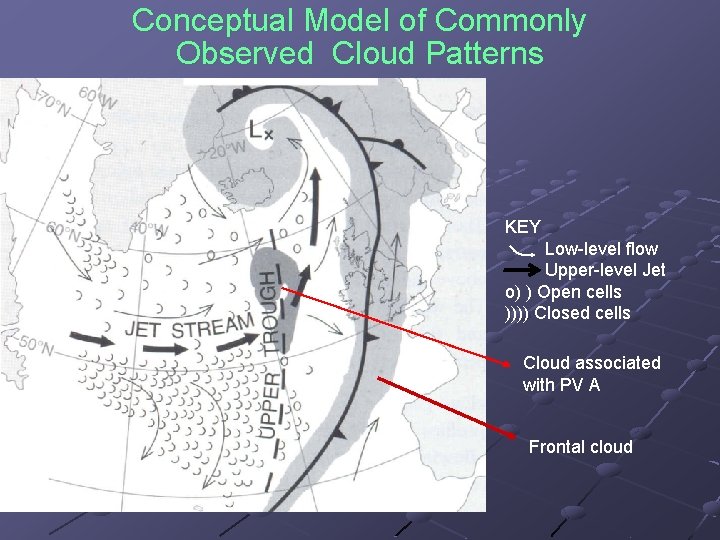
Conceptual Model of Commonly Observed Cloud Patterns KEY Low level flow Upper level Jet o) ) Open cells )))) Closed cells Cloud associated with PV A Frontal cloud

Observational studies over the East China Sea have found the following requirements for establishing a well mixed boundary layer capable of supporting convection deep enough to be seen in a satellite image: Air sea temperature difference ≥ 5°C Surface wind speed ≥ 5 m/s (10 kn)

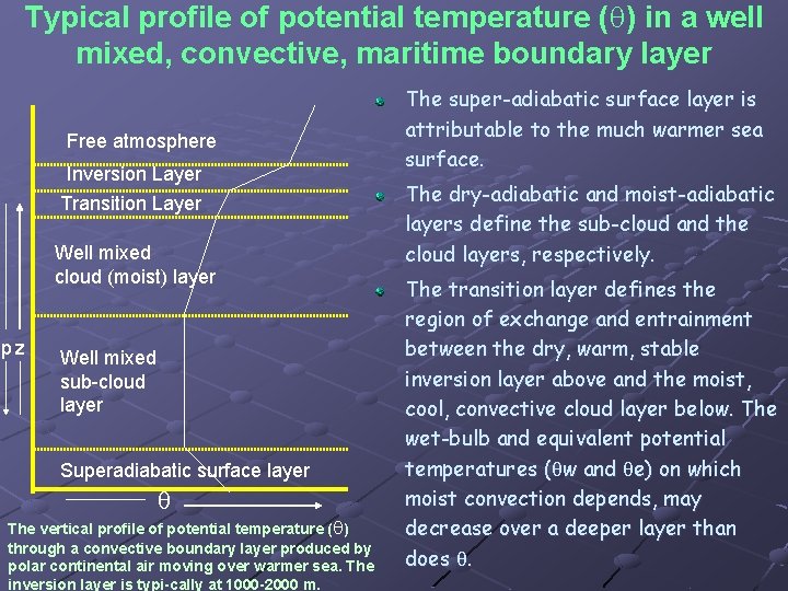
Typical profile of potential temperature ( ) in a well mixed, convective, maritime boundary layer Free atmosphere Inversion Layer Transition Layer Well mixed cloud (moist) layer pz Well mixed sub cloud layer Superadiabatic surface layer The vertical profile of potential temperature ( ) through a convective boundary layer produced by polar continental air moving over warmer sea. The inversion layer is typi cally at 1000 2000 m. The super-adiabatic surface layer is attributable to the much warmer sea surface. The dry-adiabatic and moist-adiabatic layers define the sub-cloud and the cloud layers, respectively. The transition layer defines the region of exchange and entrainment between the dry, warm, stable inversion layer above and the moist, cool, convective cloud layer below. The wet-bulb and equivalent potential temperatures ( ( w and e) on which moist convection depends, may decrease over a deeper layer than does .

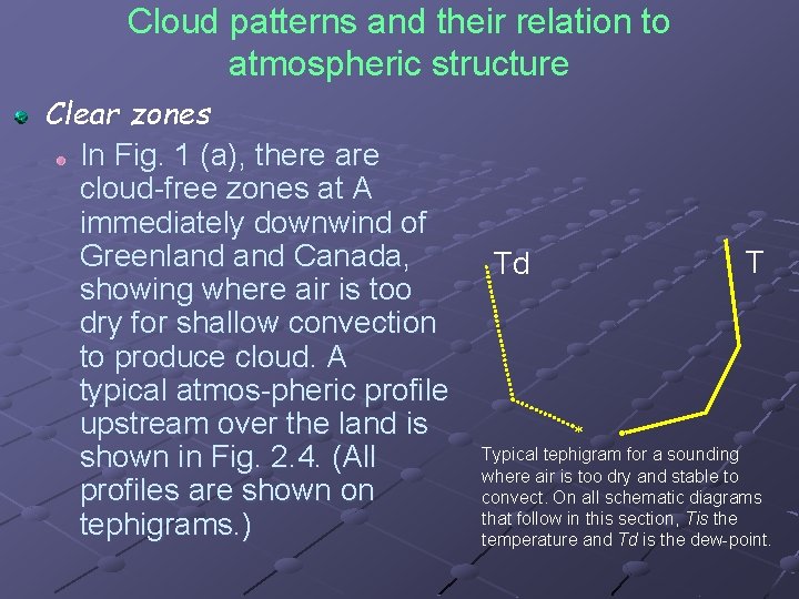
Cloud patterns and their relation to atmospheric structure Clear zones In Fig. 1 (a), there are cloud free zones at A immediately downwind of Greenland Canada, showing where air is too dry for shallow convection to produce cloud. A typical atmos pheric profile upstream over the land is shown in Fig. 2. 4. (All profiles are shown on tephigrams. ) T Td Typical tephigram for a sounding where air is too dry and stable to convect. On all schematic diagrams that follow in this section, Tis the temperature and Td is the dew point.

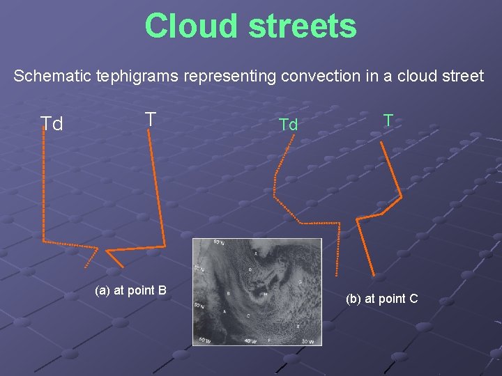
Cloud streets Ato B in Fig. , air flowing off a very cold continent has sufficient fetch over the warmer ocean to allow surface heat and moisture to destabilize a limited depth of boundary layer through mixing. When sufficiently strong convection reaches a depth exceeding the condensation level of air in the boundary layer, cloud streets become visible in satellite imagery. Streets are normally observed in an unstable layer of air 1 -3 km thick (Fig. ) where the wind direction does not change significantly with height. The layer is capped by a temperature inversion. In a shallow, well mixed boundary layer with little wind shear, streets form along the direction of the wind in the convective cloud layer. As the convection becomes deeper, e. g. along BC, the streets become wider. Streets are typically 2 -8 km apart, and this spacing is approximately three times the cloud width. Precipitation is not normally associated with cloud streets, but is possible from deeper cloud and would be in the form of light or perhaps moderate showers.

Cloud streets Schematic tephigrams representing convection in a cloud street Td T (a) at point B Td T (b) at point C

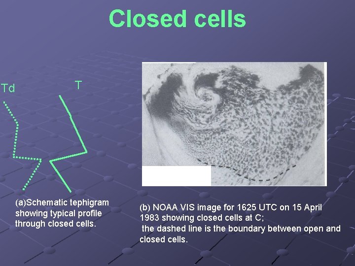
Closed cells have a quasi-hexagonal shape, with rising air in the centres and descending air at the edges. They are found in subsiding air where the unstable layer is capped by a stable layer, causing the Cu to flatten out into Sc. Thus it is the Sc that is seen rather than the Cu producing it. Closed cells are mainly associated with anticyclonic low level flow and are a standard feature in the southeastern quadrant of oceanic anticyclones (in the northern hemisphere). It is more commonly associated with weak convection (i. e. a small air-sea temperature difference) and low-level winds less than about 20 kn.

Closed cells appear bright in VIS imagery and, because of their limited vertical development, relatively warm in IR imagery. Thus, any confusion between closed cells and large individual Cu clouds with cold tops, which could appear equally bright in the VIS image, can be quickly resolved from the IR image. The boundary between open and closed cells (the dashed line on Fig. (b) gives some indication of the position of the jet stream, which is often 1 3° poleward of this boundary and has stable air on the equatorward side.

Closed cells Td T (a)Schematic tephigram showing typical profile through closed cells. (b) NOAA VIS image for 1625 UTC on 15 April 1983 showing closed cells at C; the dashed line is the boundary between open and closed cells.

Open Cells

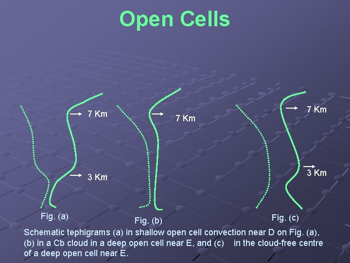
Open Cells 7 Km 3 Km Fig. (a) 7 Km 3 Km Fig. (c) Fig. (b) Schematic tephigrams (a) in shallow open cell convection near D on Fig. (a), (b) in a Cb cloud in a deep open cell near E, and (c) in the cloud free centre of a deep open cell near E.

Open Cells Patterns with mostly cloud free centres having a cloudy periphery, like those at D and E in Fig. are called open cells. They usually develop during a cold air outbreak at loca tions where the air sea temperature difference is greatest. There is normally little vertical wind shear through the cloud column. Downdraughts reaching the surface, induced partly from evaporative cooling by rain from Cb clouds, produce cloud free areas and the appearance of open rings. The anvils of any large Cb may be sheared off in the upper flow, complicating the picture. Convective cloud is often only 1 2 km deep (e. g. at D) but may be much deeper (e. g. at E); typical profiles for such points are shown in the next Fig.

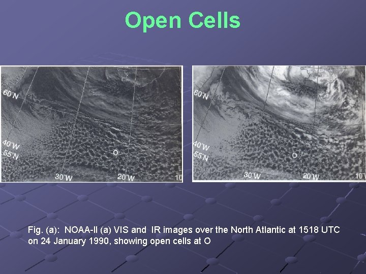
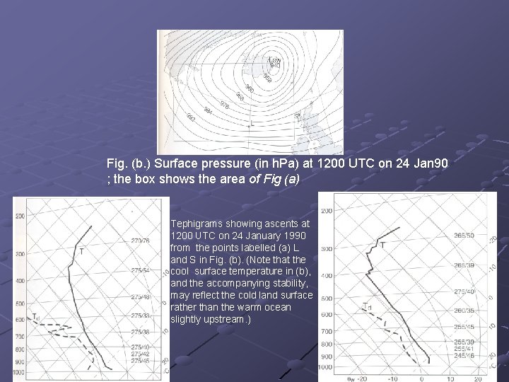
Open Cells The deepest convection occurs ahead of upper troughs and often where there is cyclonic low level flow on the synoptic scale. With wind speeds less than 20 kt at low levels, the shape of the cells is polygonal or doughnut like, and when the winds are very light they may even appear hexagonal. As wind speeds increase above 20 kt (see Fig. ), the peripheral ring may become more broken, with cells becoming increasingly irregular in shape and their dimen sions tending to increase along the flow. The diameter of the open cells is related more to the depth of instability than the wind speed. It usually increases downstream as the depth of the boundary layer increases due to convection, until a maximum depth of instability is reached (see Fig. ). The cells have aspect ratios (diameter: height) typically up to 30: 1. Fig. (a) shows an example of open cells at O over the North Atlantic in a strong westerly airflow. The surface pressure chart is shown in Fig. (b) in which the positions of two radiosonde stations are indicated by L and S. The air was being heated rapidly from below (the sea temperature was 9°C). The

Give the fig which shows o cell Vs Speed

Open Cells Fig. (a): NOAA ll (a) VIS and IR images over the North Atlantic at 1518 UTC on 24 January 1990, showing open cells at O

Fig. (b. ) Surface pressure (in h. Pa) at 1200 UTC on 24 Jan 90 ; the box shows the area of Fig (a) Tephigrams showing ascents at 1200 UTC on 24 January 1990 from the points labelled (a) L and S in Fig. (b). (Note that the cool surface temperature in (b), and the accompanying stability, may reflect the cold land surface rather than the warm ocean slightly upstream. )

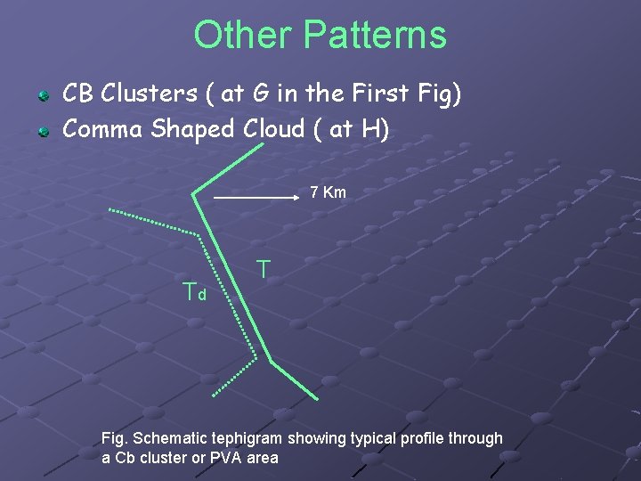
Other Patterns CB Clusters ( at G in the First Fig) Comma Shaped Cloud ( at H) 7 Km Td T Fig. Schematic tephigram showing typical profile through a Cb cluster or PVA area

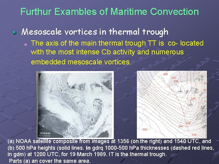
Furthur Exambles of Maritime Convection Mesoscale vortices in thermal trough The axis of the main thermal trough TT is co located with the most intense Cb activity and numerous embedded mesoscale vortices. (a) NOAA satellite composite from images at 1356 (on the right) and 1540 UTC, and (b) 500 h. Pa heights (solid lines, in gdrq 1000 500 h. Pa thicknesses (dashed red lines, in gdm) at 1200 UTC, for 19 March 1989. IT is thermal trough. Parts (a) an cover the same area.

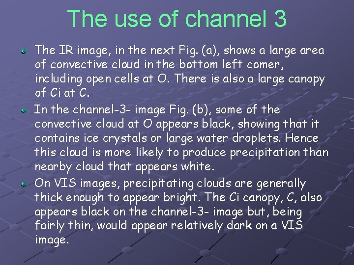
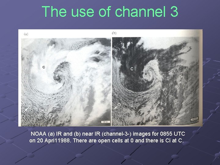
The use of channel 3 The IR image, in the next Fig. (a), shows a large area of convective cloud in the bottom left comer, including open cells at O. There is also a large canopy of Ci at C. In the channel-3 - image Fig. (b), some of the convective cloud at O appears black, showing that it contains ice crystals or large water droplets. Hence this cloud is more likely to produce precipitation than nearby cloud that appears white. On VIS images, precipitating clouds are generally thick enough to appear bright. The Ci canopy, C, also appears black on the channel-3 - image but, being fairly thin, would appear relatively dark on a VIS image.

The use of channel 3 NOAA (a) IR and (b) near IR (channel 3 ) images for 0855 UTC on 20 Apri 11988. There are open cells at 0 and there is Ci at C.

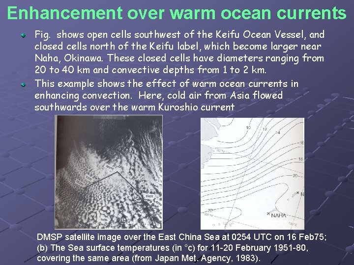
Enhancement over warm ocean currents Fig. shows open cells southwest of the Keifu Ocean Vessel, and closed cells north of the Keifu label, which become larger near Naha, Okinawa. These closed cells have diameters ranging from 20 to 40 km and convective depths from 1 to 2 km. This example shows the effect of warm ocean currents in enhancing convection. Here, cold air from Asia flowed southwards over the warm Kuroshio current DMSP satellite image over the East China Sea at 0254 UTC on 16 Feb 75; (b) The Sea surface temperatures (in °c) for 11 20 February 1951 80, covering the same area (from Japan Met. Agency, 1983).

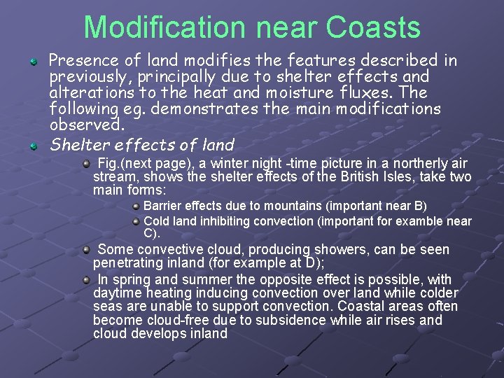
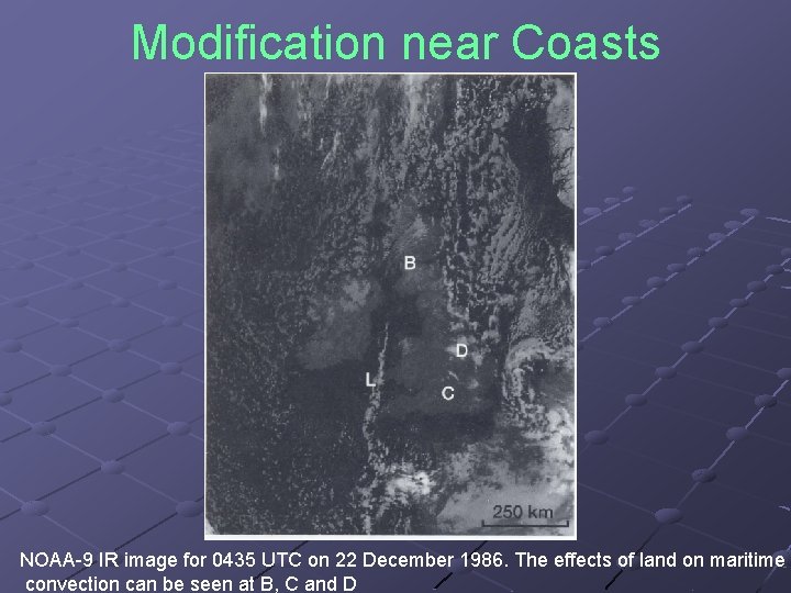
Modification near Coasts Presence of land modifies the features described in previously, principally due to shelter effects and alterations to the heat and moisture fluxes. The following eg. demonstrates the main modifications observed. Shelter effects of land Fig. (next page), a winter night time picture in a northerly air stream, shows the shelter effects of the British Isles, take two main forms: Barrier effects due to mountains (important near B) Cold land inhibiting convection (important for examble near C). Some convective cloud, producing showers, can be seen penetrating inland (for example at D); In spring and summer the opposite effect is possible, with daytime heating inducing convection over land while colder seas are unable to support convection. Coastal areas often become cloud free due to subsidence while air rises and cloud develops inland

Modification near Coasts NOAA 9 IR image for 0435 UTC on 22 December 1986. The effects of land on maritime convection can be seen at B, C and D

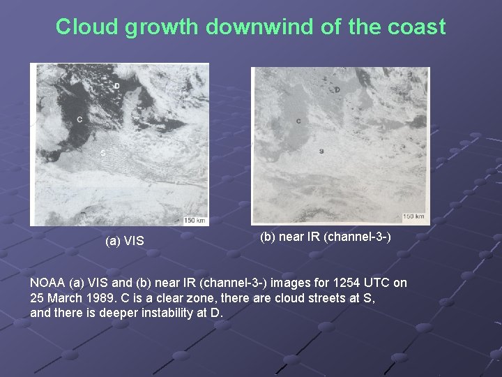
Cloud growth downwind of the coast In Fig. (a) on next page, the North Sea is clear of cloud for around 200 km downwind of Britain (at C). Further downwind, cloud streets S develop and grow, while further northeast, at D, deeper instability is evident over both land sea, with precipitating clouds highlighted by black tops in the channel-3 picture (Fig. (b).

Cloud growth downwind of the coast (a) VIS (b) near IR (channel 3 ) NOAA (a) VIS and (b) near IR (channel 3 ) images for 1254 UTC on 25 March 1989. C is a clear zone, there are cloud streets at S, and there is deeper instability at D.

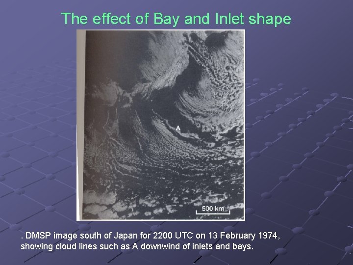
The effect of bay and inlet shape The bays and inlets can impose constraints on the shape of convective cloud patterns. Fig. on next page shows convection in a continental polar air stream south of the Japanese islands; isolated cloud lines (e. g. at A) extend down wind of coastal inlets and bays that have earlier induced convection due to localized heating over warm water.

The effect of Bay and Inlet shape . DMSP image south of Japan for 2200 UTC on 13 February 1974, showing cloud lines such as A downwind of inlets and bays.

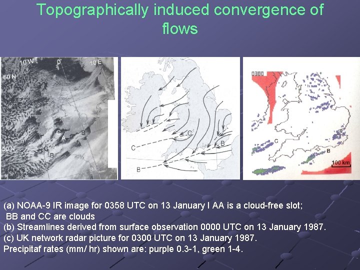
Topographically induced convergence of flows Topography and a marked land-sea temperature contrast can have pronounced effect on the distribution of cloud in polar airstreams. There are distinct cloud-free slots (e. g. at AA) over the warm sea down wind of peninsulas, whereas cloud quickly forms (e. g. at BB and CC) over the relatively warm inlets, bays and straits. Here, there is convergence at low levels as the flow over the sea meets the backed flow over the rougher land (Fig. on next page). The bands produce lines of showers, Fig. (c).

Topographically induced convergence of flows (a) NOAA 9 IR image for 0358 UTC on 13 January I AA is a cloud free slot; BB and CC are clouds (b) Streamlines derived from surface observation 0000 UTC on 13 January 1987. (c) UK network radar picture for 0300 UTC on 13 January 1987. Precipitaf rates (mm/ hr) shown are: purple 0. 3 1, green 1 4.

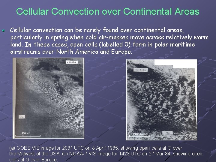
Cellular Convection over Continental Areas Cellular convection can be rarely found over continental areas, particularly in spring when cold air-masses move across relatively warm land. In these cases, open cells (labelled 0) form in polar maritime airstreams over North America and Europe. (a) GOES VIS image for 2031 UTC on 8 Apri 11985, showing open cells at O over the Midwest of the USA. (b) NOAA 7 VIS image for 1423 UTC on 27 Mar 84, showing open cells at O over Europe.