CONTINENTAL DRIFTPANGAEA 6 TH GRADE SCIENCE Mrs Tabetha

CONTINENTAL DRIFT/PANGAEA 6 TH GRADE SCIENCE Mrs. Tabetha Cooksey

SUPPORT FOR CONTINENTAL DRIFT 1. SHAPE OF THE CONTINENTS Continents fit together like puzzle pieces (Jigsaw)

SUPPORT FOR CONTINENTAL DRIFT 1. SHAPE OF THE CONTINENTS • Wegener was not the only one to notice the fit of the continents. • 1858: Antonio Pelligrini depicted Africa and South America connected. • He was one of the first scientists to publish maps depicting the apparent fit of the continents.

SUPPORT FOR CONTINENTAL DRIFT 2. FOSSIL EVIDENCE SAME FOSSILS: DIFFERENT CONTINENTS Mesosaurus was incapable of swimming across a large ocean.

SUPPORT FOR CONTINENTAL DRIFT 3. ROCK EVIDENCE – Mountain ranges § SAME ROCK: DIFFERENT RANGE Existing mountain ranges separated by vast oceans contain rocks of identical mineral content. § A prime example are the Appalachian Mountains in the eastern U. S and the Caledonian Mountains in the British Isles.

Support for Continental Drift 4. GLACIAL SCARS SAME SCARS: DIFFERENT CONTINENTS

Support for Continental Drift 5. LOCATION OF COAL DEPOSITS Coal deposits have been found in temperate and polar regions; however, coal is formed in tropical regions.

CONTINENTAL DRIFT IN DOUBT Why didn’t people believe in continental drift? • People couldn’t image how the earth could be millions of years old • People couldn’t image a force great enough to move the continents BUT by the 1960’s evidence would prove continental drift is TRUE and…. The story continues (as does all good science!)

DECEMBER 9 TH, 2014 I CAN DESCRIBE CONTINENTAL DRIFT AND THEORY OF PLATE TECTONICS. Continents Adrift: An Introduction to Continental Drift and Plate Tectonics | Discovery Education You have vocabulary terms attached to your interactive. Use any resources that you choose to use—textbook, personal devices, laptops, etc. to locate the terms for each vocabulary description. Then…based on your geographical sense identify each tectonic plate.

TECTONIC PLATES

CONTINENTAL DRIFT Alfred Wegener 1900’s Continents were once a single land mass that drifted apart. Fossils of the same plants and animals are found on different continents Called this supercontinent Pangea, Greek for “all Earth” 245 Million years ago Split again – Laurasia & Gondwana 180 million years ago http: //members. enchantedlearning. com/subjects/astronomy/planets/earth/Continents. shtml

EVIDENCE OF PANGEA

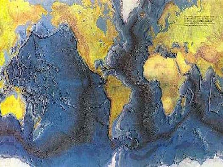
SEA FLOOR SPREADING

SEA FLOOR SPREADING • Mid Ocean Ridges – underwater mountain chains that run through the Earth’s Basins • Magma rises to the surface and solidifies and new crust forms • Older Crust is pushed farther away from the ridge

HOW PLATES MOVE http: //pubs. usgs. gov/gip/dynamic/unanswered. html

DIFFERENT TYPES OF BOUNDARIES http: //pubs. usgs. gov/gip/dynamic/understanding. ht

DIVERGENT BOUNDARY – ARABIAN AND AFRICAN PLATES Arabian Plate Red Sea African Plate

DIVERGENT BOUNDARY - OCEANIC http: //www. geology. com

DIVERGENT BOUNDARY - CONTINENTAL http: //www. geology. com

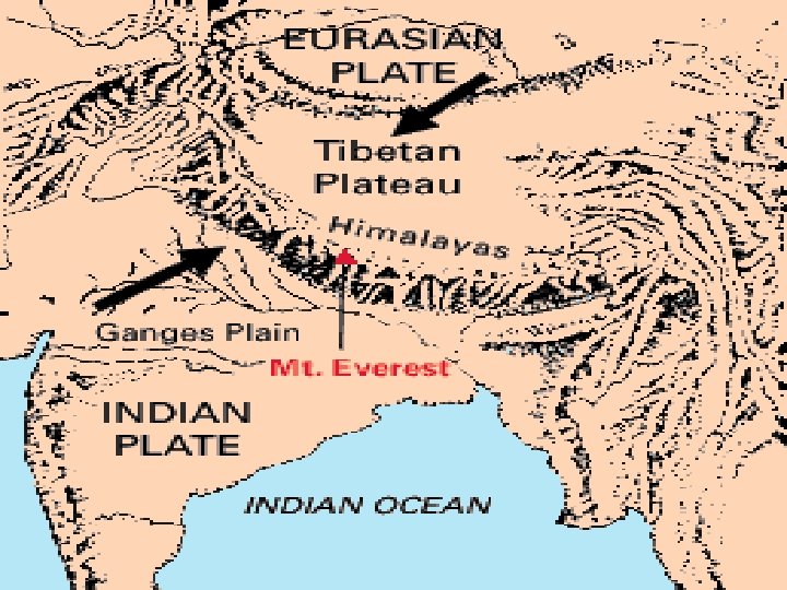
CONVERGENT BOUNDARY – INDIAN AND EURASIAN PLATES Eurasian Plate Indian Plate

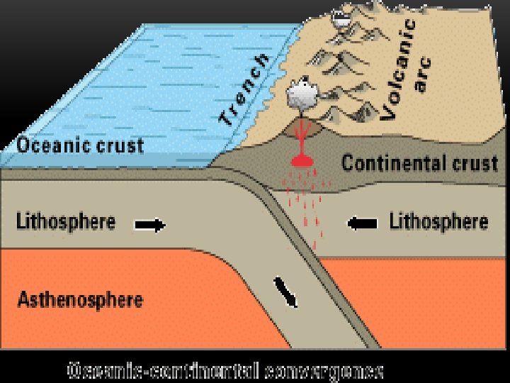
CONVERGENT BOUNDARY – OCEANIC & CONTINENTAL http: //pubs. usgs. gov/gip/dynamic/understanding. html & http: //www. geology. com

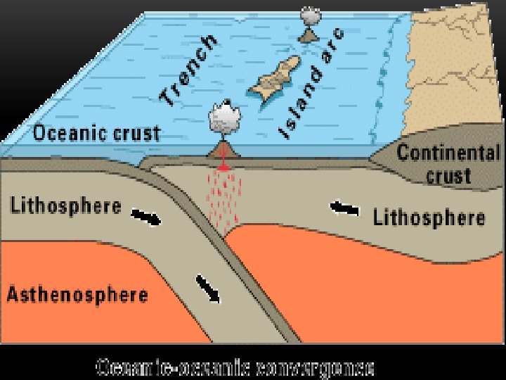
CONVERGENT BOUNDARY – OCEANIC & OCEANIC NOTE – PLATES ARE REVERSED http: //pubs. usgs. gov/gip/dynamic/understanding. html & http: //www. geology. com

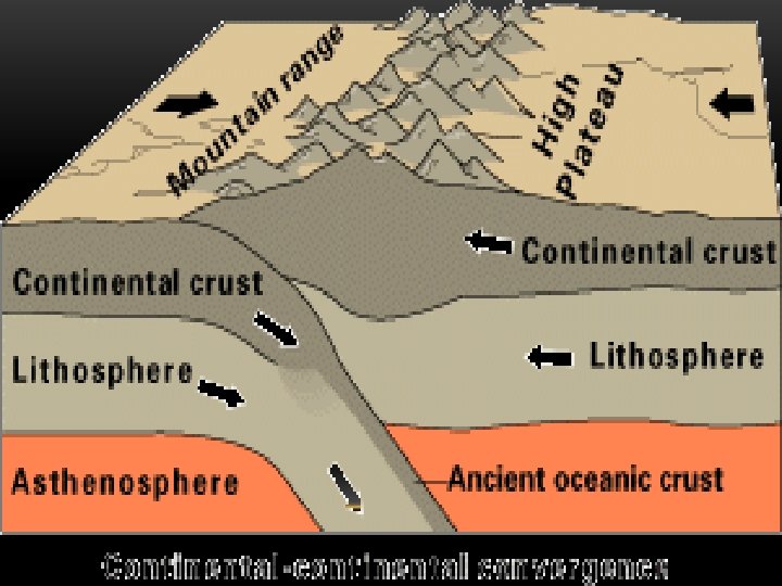
CONVERGENT BOUNDARIES - CONTINENTAL http: //pubs. usgs. gov/gip/dynamic/understanding. html & http: //www. geology. com

TRANSFORM BOUNDARY – SAN ANDREAS FAULT www. geology. com

REVIEW • Name the 3 main layers of the Earth • What is a tectonic plate? • What was Pangea? • What is Sea-Floor spreading? • Name three different types of plate boundaries and one location on Earth for each one

DECEMBER 10 TH, 2014 I CAN DESCRIBE CONTINENTAL DRIFT AND THEORY OF PLATE TECTONICS. I CAN COMPARE AND CONTRAST PLATE BOUNDARIES. I CAN RECOGNIZE AND DESCRIBE FEATURES THAT ARE CAUSED BY PLATE BOUNDARIES. Describe the difference between an oceanic crust and continental crust. What characteristics make them differ? Today we will be completing a lab that will demonstrate the results of plate movement!

DIVERGENT PLATE BOUNDARIES

• The Mid-Atlantic Ridge, which splits nearly the entire Atlantic Ocean north to south, is probably the best-known and moststudied example of a divergent-plate boundary.
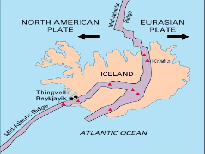

• Aerial view of the area around Thingvellir, Iceland, showing a fissure zone (in shadow) that is the on-land exposure of the Mid-Atlantic Ridge. Right of the fissure, the North American Plate is pulling westward away from the Eurasian Plate

• East Africa may be the site of the Earth's next major ocean. Plate interactions in the region provide scientists an opportunity to study first hand how the Atlantic may have begun to form about 200 million years ago. Geologists believe that, if spreading continues, the three plates that meet at the edge of the present-day African continent will separate completely, allowing the Indian Ocean to flood the area and making the easternmost
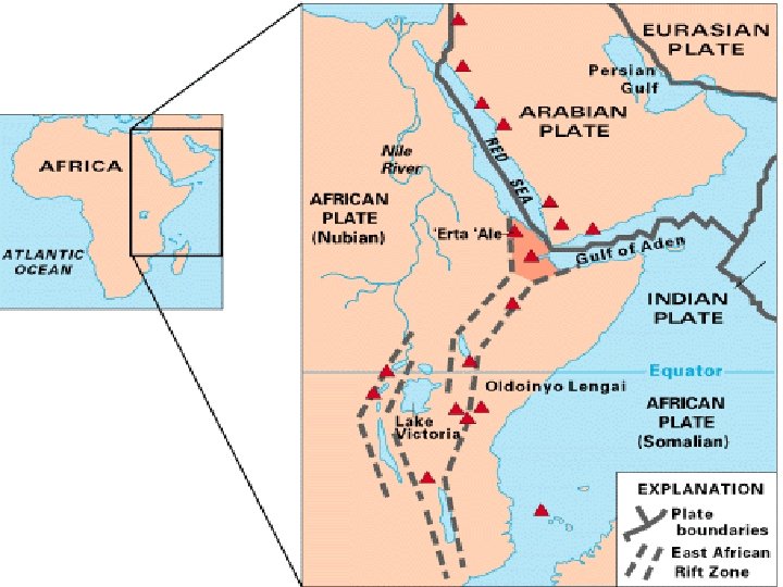

DIVERGENT BOUNDARY – ARABIAN AND AFRICAN PLATES Arabian Plate Red Sea African Plate

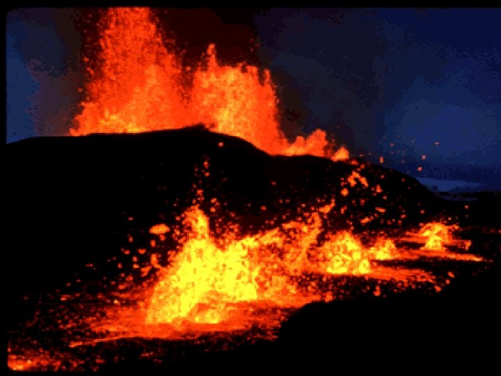
DIVERGENT BOUNDARY – ICELAND http: //pubs. usgs. gov/gip/dynamic/understanding. html

DIVERGENT BOUNDARY - OCEANIC http: //www. geology. com

DIVERGENT BOUNDARY - CONTINENTAL http: //www. geology. com

CONVERGENT PLATE BOUNDARIES 3 Types of Convergent Boundaries Ocean to Continent Ocean to Ocean Continent to Continent

• The convergen ce of the Nazca and South American Plates has deformed and pushed up limestone strata to form towering
 before")
• The 6, 000 km-plus journey of the India landmass (Indian Plate) before its collision with Asia (Eurasian Plate) about 40 to 50 million years ago

• Sunset view of towering, snow-capped Mt. Everest, from the village of Lobuche (Solu-

CONVERGENT BOUNDARY – INDIAN AND EURASIAN PLATES Eurasian Plate Indian Plate

CONVERGENT BOUNDARY – OCEANIC & CONTINENTAL http: //pubs. usgs. gov/gip/dynamic/understanding. html & http: //www. geology. com

CONVERGENT BOUNDARY – OCEANIC & OCEANIC NOTE – PLATES ARE REVERSED http: //pubs. usgs. gov/gip/dynamic/understanding. html & http: //www. geology. com

CONVERGENT BOUNDARIES - CONTINENTAL http: //pubs. usgs. gov/gip/dynamic/understanding. html & http: //www. geology. com


TRANSFORM BOUNDARIES

• The Blanco, Mendocino, Murray, and Molokai fracture zones are some of the many fracture zones (transform faults) that scar the ocean

The San Andreas fault zone, which is about 1, 300 km long and in places tens of kilometers wide, slices through two thirds of the length of California. Along it, the Pacific Plate has been grinding horizontally past the North American Plate for 10 million years, at an average rate of

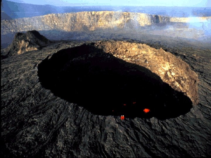
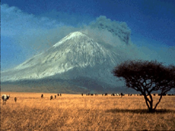
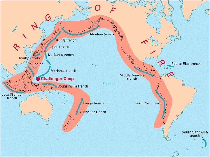
HOTSPOTS Regions of earthquake and volcanic activity which do not occur along plate boundaries

• The vast majority of earthquakes and volcanic eruptions occur near plate boundaries, but there are some exceptions
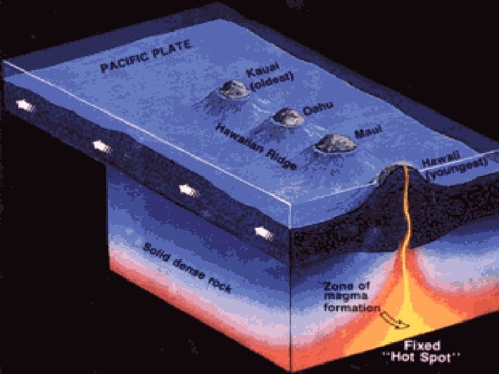
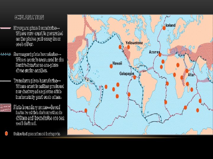

• Map of part of the Pacific basin showing the volcanic trail of the Hawaiian hotspot-- 6, 000 -kmlong Hawaiian Ridge-Emperor Seamounts chain

TRANSFORM BOUNDARY – SAN ANDREAS FAULT www. geology. com

SAN ANDREAS FAULT

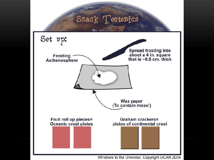
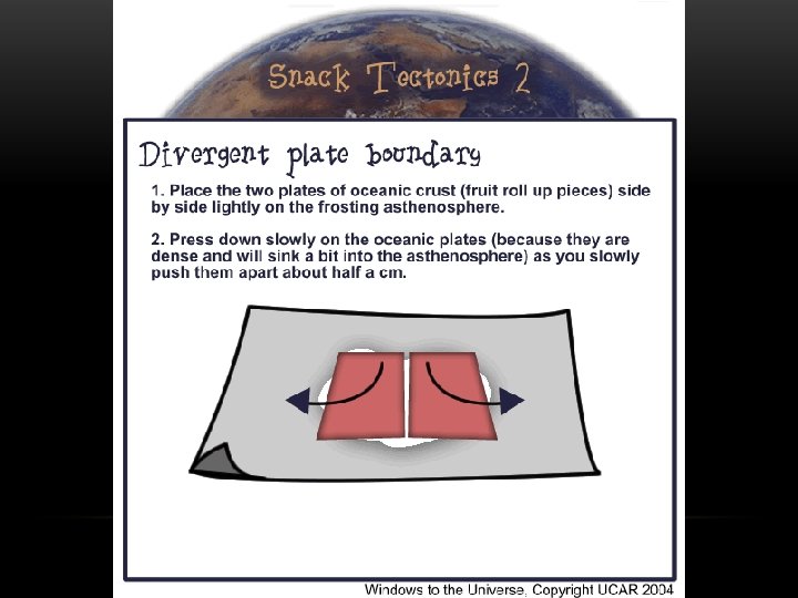
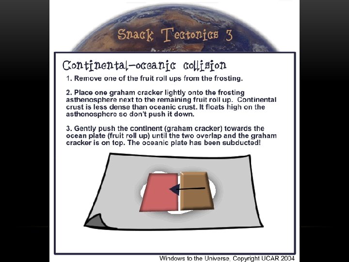
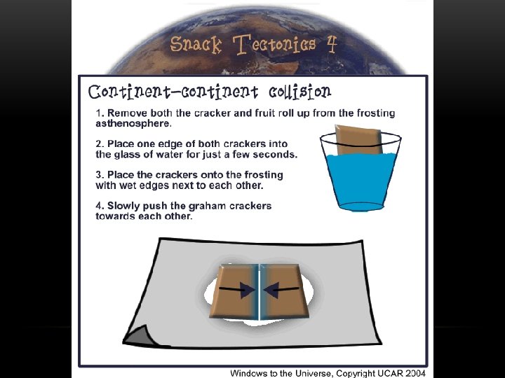
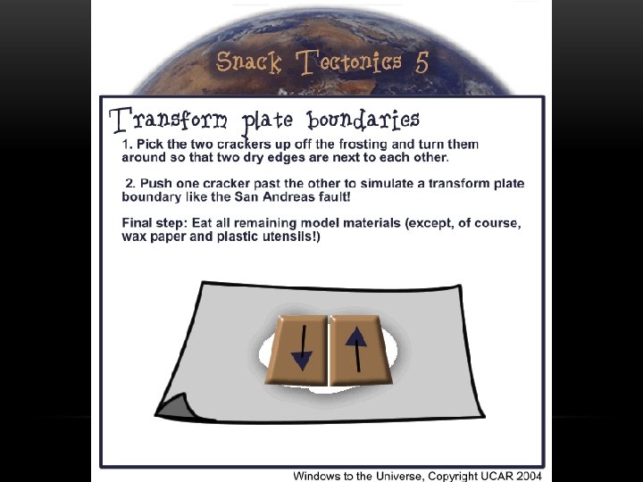
Data Analysis Questions: IN COMPLETE SENTENCES 1. What type of crust is represented by the graham crackers? 2. What type of crust is represented by the fruit roll-up? 3. What physical layer of the earth does the frosting represent? 4. Give one real –life example of each type of plate boundary: (geographic location and how it was formed) • Continental- Continental Collision • Oceanic-Continental Collision • Transform Boundary • Divergent Boundary 5. What are some of the limitations of the models you’ve created? What are some physical and topographic features that were not represented by the models? Works Cited: Have a works cited section with all the sources used to find information on the background info section as well as the data analysis.

DECEMBER 11 TH, 2014 I CAN DESCRIBE CONTINENTAL DRIFT AND THEORY OF PLATE TECTONICS. I CAN COMPARE AND CONTRAST PLATE BOUNDARIES. I CAN RECOGNIZE AND DESCRIBE FEATURES THAT ARE CAUSED BY PLATE BOUNDARIES. You was asked to complete the discussion questions post-lab. You will have 15 minutes to work on each part on your lab sheet. Make sure you also illustration your observation in each section. Identify the three plate boundaries and with arrows show their plate movement. Provide examples of what results.

DECEMBER 12 TH, 2014 --REVIEW I CAN DESCRIBE CONTINENTAL DRIFT AND THEORY OF PLATE TECTONICS. I CAN COMPARE AND CONTRAST PLATE BOUNDARIES. I CAN RECOGNIZE AND DESCRIBE FEATURES THAT ARE CAUSED BY PLATE BOUNDARIES. Get your study guide out and devices. Sign in to Kahoot Draw the layers of the earth and describe, in detail, how each layers contributes to theory of plate tectonics.

DECEMBER 13 TH, 2014 --REVIEW LEARNING TARGETS—HISTORY OF EARTH PART 2 3 rd Period: Kahoot Get your study guides out and mark all of the questions that you would like extra help with or have a question about. This is the time to lay all the card out on the table

DESCRIBE THEORY OF CONTINENTAL DRIFT • All the continents were all one single landmass (Pangaea. Supercontinent) and have since drifted apart

PANGAEA • Supercontinent- the one single landmass that was made of all of the land on Earth- part of theory of continental drift

WHICH TWO CONTINENTS ARE USED AS EVIDENCE FOR THE CONTINENTAL PUZZLE? • South America and Africa
 Continents fit like a jig")
EVIDENCE TO SUPPORT THEORY OF CONTINENTAL DRIFT. • 1) Continents fit like a jig saw puzzle • 2) Alike fossils of plants and animals on different continents • 3) Mountain ranges on different continents match up • 4) Glacier evidence—striation or dump sites • 5) Coal deposits

CONTINENTAL DRIFT REJECTED AT FIRST? • _____ could not explain the force that could move the large continents

DEVELOPED THEORY OF CONTINENTAL DRIFT? • Alfred Wegener

THEORY OF SEA-FLOOR SPREADING. • Molten material rises from the mantle at the mid –ocean ridge and pushes older rock to both sides- continually adds new crust

EVIDENCE FOR SEA-FLOOR SPREADING. • Molten material that cools suddenly called pillow lave was found at the ridge • Drilling Samples revealed older rocks at the trenches and younger rocks at the ridge • Magnetic striping along both sides of the ridge matched

WHAT OCCURS ALONG THE DEEP OCEAN TRENCHES? • _____ – the oceanic crust sinks beneath a deep-ocean trench and back into the mantlecrust is destroyed

WHAT ARE MOVING PLATES MADE UP OF? • Lithosphere + Crust

WHAT LAYER OF THE EARTH ARE MOVING PLATE “FLOATING” ON? • Asthenosphere

DESCRIBE THE DIFFERENCE BETWEEN THE TWO TYPES OF PLATES • Continental Crust: Thicker; Less Dense • Oceanic Crust: Thinner: More Dense
 TO IDENTIFY THE 3 TYPES OF PLATE BOUNDARIES: Convergent Boundary")
DRAW AND LABEL (ARROWS) TO IDENTIFY THE 3 TYPES OF PLATE BOUNDARIES: Convergent Boundary Divergent Boundary Transform

TOGETHER, CAUSING ONE PLATE TO DESCEND BENEATH THE OTHER? EXPLAIN. • Subduction Zone: Weaker plate descends to produce a “trench”; This can be oceanic-continental or oceanic-oceanic. (Convergence)

WHAT IS A “PLATE” IN GEOLOGIC TERMS? • Rock!
 CAUSED THE FOLLOWING? Sea Floor Spreading: Divergence Example:")
WHAT TYPE OF BOUNDARY (OR PHENOMENA) CAUSED THE FOLLOWING? Sea Floor Spreading: Divergence Example: Mid Atlantic Ridge (Rift Valley)
 CAUSED THE FOLLOWING? Subduction Zone: Convergence Trench –Volcanic")
WHAT TYPE OF BOUNDARY (OR PHENOMENA) CAUSED THE FOLLOWING? Subduction Zone: Convergence Trench –Volcanic Arcs and Island Arcs Oceanic-Continental Oceanic-Oceanic
 CAUSED THE FOLLOWING? Earthquake: Transform Boundary Example: San")
WHAT TYPE OF BOUNDARY (OR PHENOMENA) CAUSED THE FOLLOWING? Earthquake: Transform Boundary Example: San Andreas Fault
 CAUSED THE FOLLOWING? Volcanic Island: Convergence example: Hawaii")
WHAT TYPE OF BOUNDARY (OR PHENOMENA) CAUSED THE FOLLOWING? Volcanic Island: Convergence example: Hawaii
 CAUSED THE FOLLOWING? Mountain Range: Convergence Example: Andes,")
WHAT TYPE OF BOUNDARY (OR PHENOMENA) CAUSED THE FOLLOWING? Mountain Range: Convergence Example: Andes, Himalayas (Mt. Everest)
")
WHAT LAYER OF EARTH IS DIVIDED INTO PLATES? • Moving plates (Crust and Lithosphere) • Floating on Asthenosphere
 AND WHAT TYPE OF BOUNDARY OCCURS?")
WHAT IS A RIFT VALLEY (MID OCEAN RIDGE) AND WHAT TYPE OF BOUNDARY OCCURS? (REPEAT) • Sea Floor Spreading/Divergent Boundary
 • Mid Ocean")
WHAT IS A GEOGRAPHIC EXAMPLE OF A DIVERGENT PLATE BOUNDARY? (REPEAT) • Mid Ocean Ridge (Rift Valley)— Between N. America/S. America and Europe/Africa

WHAT IS A GEOGRAPHIC EXAMPLE OF A CONTINENTAL-CONTINENTAL CONVERGENT BOUNDARY? • Andes Mountains in South America • Himalayas (Mt. Everest) in Europe
- Slides: 98