Continental Drift to Plate Tectonics Alfred Wegeners Early


- Slides: 58
Continental Drift to Plate Tectonics
Alfred Wegener’s Early Evidence
Wegener’s Evidence • 1. The Puzzle like fit of the continents. • 2. Ancient glacier tracks (glacier striations). • 3. Matching Geologic features on different continents. • 4. Matching fossils on different continents (paleontology).
For centuries people noticed the puzzle like fit of the continents
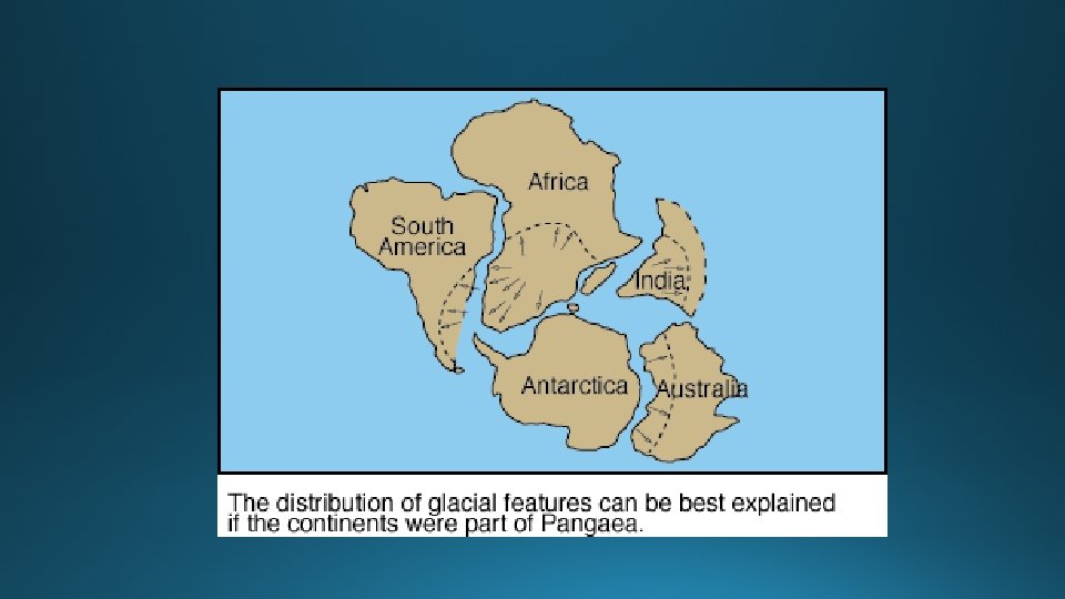
Wegener’s Pangaea
Ancient Glacier lines match up when the continents are united.
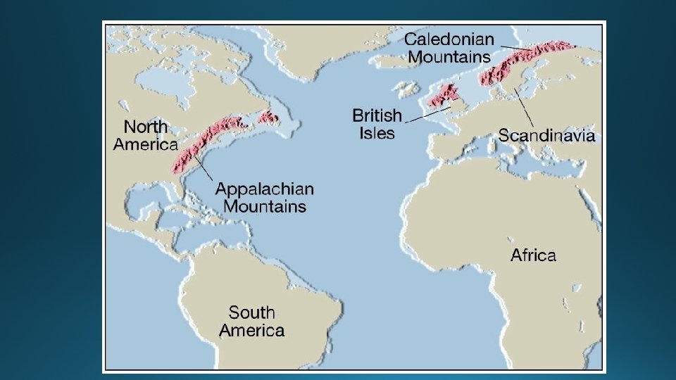
Geologic features match on different continents when united.
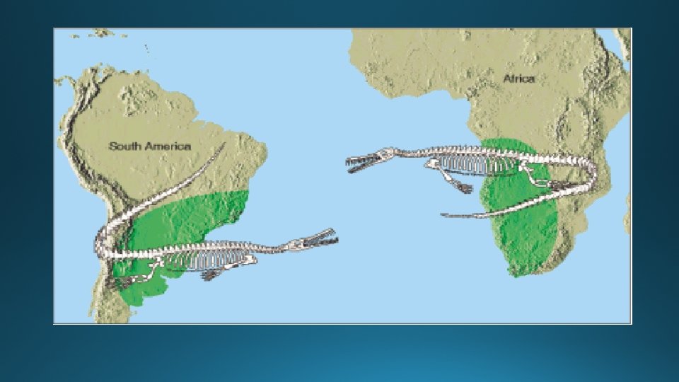
Extinct fossils on different continents
Wegener’s Hypothesis • In 1928 Wegener proposed his hypothesis and supporting evidence to a skeptical scientific community. • Wegener’s ideas were overwhelming rejected and he was ridiculed. • PROBLEM: What force was strong enough to push the continents through the solid bedrock or the ocean floor?
Wegener dies in 1930 along with his ideas about continents drifting.
What do these scientist have in common? • Alfred Wegener • Galileo Galilee • Nicholas Copernicus • Charles Darwin
• All proposed a radical hypotheses that went against the grain of conventional teachings. • Their ideas were originally rejected because they could not explain the mechanism or reason supporting their hypothesis.
WWII & the invention of Sonar
Mapping the Ocean Floor
1950’s-60’s New Evidence for Continental Drift: Mid Atlantic Ridge
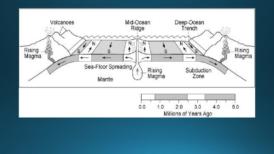
Concept of Sea Floor Spreading
Evidence for Sea Floor Spreading • Youngest rock are found near the Mid Ocean Ridge, Oldest rocks are found near the continents. • Pillow Lava found in the rift of the Mid Atlantic Ridge • Magnetic Reversals: A mirror image recorded like zebra stripes on both sides of the Mid Atlantic Ridge. • Satellite measurements show that the width of the Atlantic Ocean is increasing by 2 to 3 inches per year.
Glomar Challenger
Alvin submersible
Sea Floor Spreading & Magnetic Reversals
Mirror Image of magnetic Reversals
Satellite Measurements show the continents are moving
Plate Tectonics says earth’s crust is divided into sections or plates.
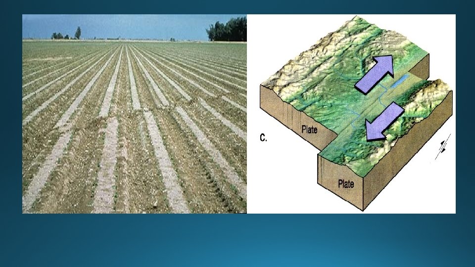
Three types of plate boundaries • Transform Boundary: A lateral side by side sliding of the plates = earth quake zone. Example, San Andreas Fault • Divergent Boundary: Plates moving apart. Sea floor spreading in the Mid Atlantic Ridge, East African Rift, Iceland! • Converging Boundary: Three types of plate collisions. • 1. Ocean + Continent = Trench & volcanic Mt. Range. • 2. Ocean + Ocean = Deep trench & Volcanic Islands. • 3. Continent + Continent = Large mountain range.
Plate Boundaries
Transform Boundary: San Andreas Fault
San Andreas Fault
Divergent Plate Boundaries
Iceland is on the Mid Atlantic Ridge
Iceland’s Wall of Lava
East African Rift & Red Sea
Volcano in East African Rift
3 types of converging boundaries
Convergent Plates: Ocean + Continent
#1 Convergence: Cont. + Ocean crust • The dense ocean crust is shoved below the lighter continental crust. This creates a deep ocean trench (subduction zone) and a volcanic mountain range on land. • Examples: Cascade Mountain Range & The Andes of South America.
Plate Boundaries
Peru - Chile Trench & the Andes
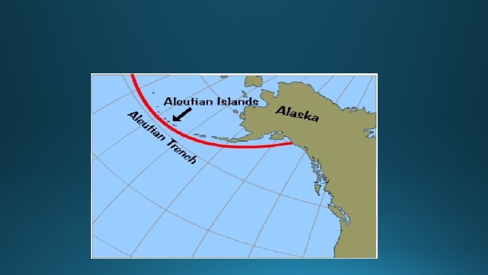
#2 Convergence: Ocean + Ocean crust • The dense ocean crust is subducted down into a deep ocean trench and creates a volcanic Island arc. • Examples: Mariana’s trench with Japan, Indonesia & the Philippine plate.
Ocean + Ocean Convergence
Japan & the Mariana’s Trench
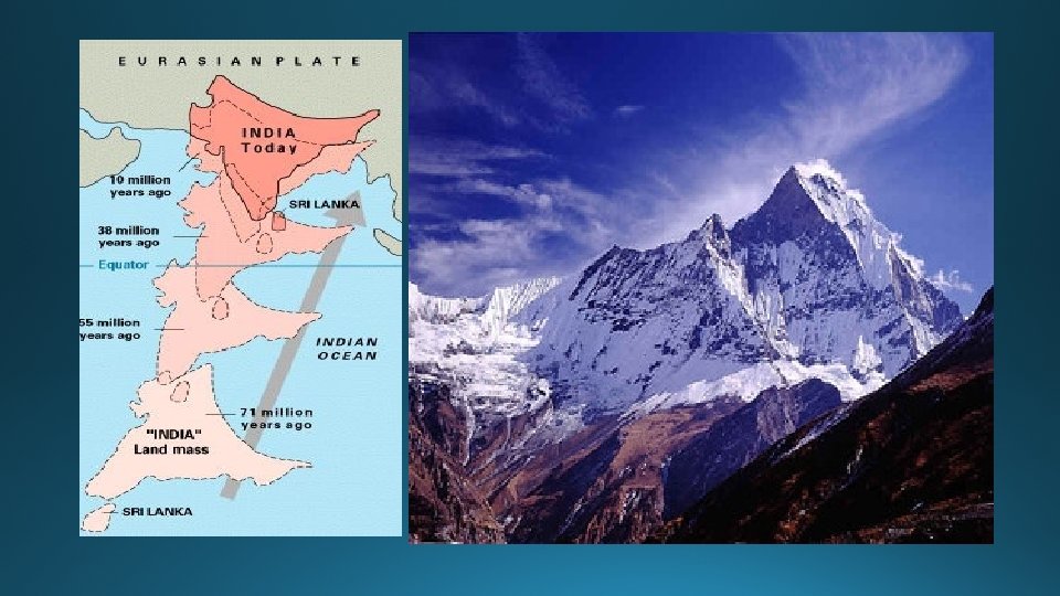
Convergence Continent + Continent • The lighter continental crust collide forming a large mountain range. • The collision with India & Asia created the Himalayan Mountains.
Continental Collision
Driving force in Plate Tectonics: Earth’s internal heat = Convection Zones
Slab Pull adds to the plate motion
The Ring of Fire
Distribution of Earth Quakes
Age of Ocean Crust
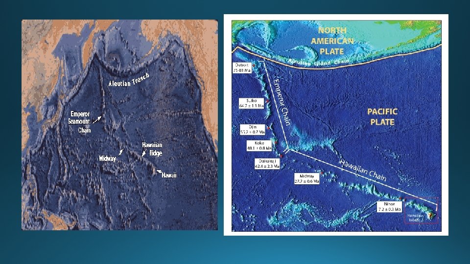
What about Hawaii in the middle of the Pacific Plate?
Fixed Hot Spot burns a hole in the Pacific Plate
The Hawaiian Chain