Content Objective Compare the physical and political regions

• Content Objective: – Compare the physical and political regions. • Language Objectives: – SWBAT define region. – SWBAT locate and list the states in each region

Map of the 50 States There are practice options on my teacher website if you want/need them!

Geography - Regions

Region Definition • Region- A specified grouping of states with common characteristics

Physical vs. Political Regions • Last year you learned about physical regions, and this year you are learning about political regions –What are some characteristics that make up a physical region? (Write them down)
 describes the climate and landforms,")
Physical Regions • A physical region (6 th grade) describes the climate and landforms, which are the natural characteristics of the land.
 can be defined as a")
Political Regions • A political region (7 th grade) can be defined as a state or group of states, depending on the criteria used. For example, geography is often used to determine political regions, so states in the same parts of the country are grouped together.
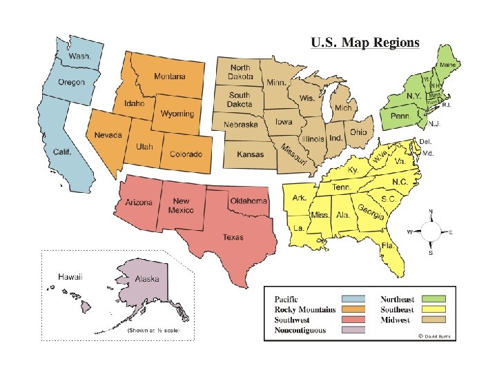

Political Regions: • Northeast – Maine, Vermont, New Hampshire, Connecticut, Massachusetts, Rhode Island, New York, New Jersey, Pennsylvania • Southeast – Maryland, Delaware, West Virginia, Kentucky, Tennessee, North Carolina, South Carolina, Georgia, Florida, Alabama, Mississippi, Louisiana, Arkansas

Regions cont: • Midwest – Ohio, Indiana, Illinois, Michigan, Wisconsin, Minnesota, Iowa, Missouri, Kansas, Nebraska, South Dakota, North Dakota • Southwest – Texas, Oklahoma, New Mexico, Arizona
 – Colorado, Utah, Nevada, Montana, Wyoming, Idaho •")
Regions cont: • Rocky Mountains (Western) – Colorado, Utah, Nevada, Montana, Wyoming, Idaho • Pacific – Washington, Oregon, California • Noncontiguous – Alaska & Hawaii
- Slides: 11