CONFLICTS AMONG COUNTRIES CAUSES OF NATIONAL CONFLICTS CONFLICTS


, Saudi Arabia (upper")


 w To transport")


- Slides: 33
CONFLICTS AMONG COUNTRIES CAUSES OF NATIONAL CONFLICTS
CONFLICTS AMONG COUNTRIES w International conflicts take many forms w War of words w Economic/Trade War w Indications of rising tension – Increased navy patrols – Massing of troops at borders
CONFLICTS AMONG COUNTRIES w Resolve crisis through talking w When this fails, armed conflict or war is possible w Stronger party will force weaker party to agree to certain terms w Eg giving up territory w Sometimes conflict spreads beyond national boundaries to involve other countries as well
WHY DO CONFLICTS OCCUR AMONG COUNTRIES? w Competition for Scarce Natural Resources – Conflict over fishing grounds – Conflict over water supplies w Different Values and Beliefs – Conflict between Democracy and Communism w Competing Claims over Territory – Conflict over border
Competition for Scarce Natural Resources CONFLICT OVER FISHING GROUND : Iceland vs Britain
Vatnajökull Ice Cap - This photo shows the ice cap as it appears in late summer. Vatnajökull, in south-eastern Iceland, covers an area of about 8100 square kilometers and is the largest ice cap in Europe. The red areas in this false color image are those areas covered with vegetation. Dark areas are lava fields and water.
British Isles. Cloudless satellite image, approximating to true colours, of the British Isles. North is at top. The island of Great Britain (at right) consists of the realms of England (at lower right) and Scotland (at upper centre), and the principality of Wales (at lower centre). The secondlargest island is Ireland (at left). There about 5000 islands and islets in the British Isles. Image comprised of data collected by the Landsat 5 satellite.
CONFLICT OVER FISHING GROUND w Iceland Britain in the 1970 s w Iceland – few natural resources w Depends on fishing industry for survival w Fresh fish and fish products – 79% of Iceland’s total export
CONFLICT OVER FISHING GROUND w 1970 s : Fish stocks around Iceland decreased by 1/3 w Foreign fishermen – Belgium, Germany, mostly Britain – overfishing around Iceland wanted fish catches of these countries to be reduced
CONFLICT OVER FISHING GROUND w As Iceland is more dependent on fishing than other countries, it argued that the other countires should first reduce their catches w Suggested to UN Conference on Law of the Sea several ways to regulate fishing w What ways can you think of?
CONFLICT OVER FISHING GROUND w Disallow fishermen to fish in breeding grounds – give young fish time to grow, mature and multiply w Place quotas on tonnage of fish caught w Rotate preservation areas w Unfortunately, most of these suggestion were ignored or at best accepted slowly
CONFLICT OVER FISHING GROUND w Oct 1975 : Iceland extended zone of control over fishing grounds from 50 to 200 nm beyond its shore w Fishermen from Belgium, France and Norway complied but not Britain w Continued to fish inside disputed area w What would you do if you were the PM of Iceland?
CONFLICT OVER FISHING GROUND w Nov 1975 : Serious disagreement between Britain and Iceland over fishing rights w Iceland’s Coast Guard vessels attempted to force British trawlers to stop fishing in Iceland’s extended territorial waters w To protect their fishermen, British sent their frigates or small naval ships to patrol the waters operated by their trawlers
FISHING TRAWLER
CONFLICT OVER FISHING GROUND w Frequent collisions between British frigates and Iceland’s vessels w Each blamed the other naturally – recall USChina tiff over surveillance plane in Apr 2001? w Both could not resolve the conflict in a peaceful and friendly manner w Result : Iceland broke off diplomatic ties with Britain in Feb 1976
CONFLICT OVER FISHING GROUND w Fortunately, conflict did not turn into armed conflict w Resolved in Jun 1976 through an agreement w Britain – catch fixed amount of fish w Maximum of 24 trawlers inside the 200 nm zone at any one time w Iceland’s patrol vessels allowed to stop and inspect trawlers suspected of violating agreement w Lasted for 6 months after which Britain had no more right to fish in the 200 nm zone
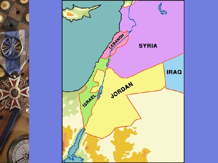
Competition for Scarce Natural Resources CONFLICT OVER WATER SUPPLIES : Israel vs Jordan
CONFLICT OVER WATER SUPPLY w Conflict between Israel and Jordan over water supply w Competition over shared water resources led to conflicts between them w Jordan River supplies both Israel and Jordan with most of their water supply
This true-color image of Lake Tiberias the region was taken on September 10, 2000, by the MODerate-resolution Imaging Spectroradiometer (MODIS) flying aboard NASA's Terra spacecraft. The image shows the lands of Israel along the eastern shore of the Mediterranean Sea, with the countries of Jordan to the southeast and Syria to the Northeast. Jerusalem, labeled, is Israel's capital city and Aman, labeled, is the capital of Jordan. The region known as the West Bank lies between the two countries. Running from north to south, the Jordan DEAD SEA River links the Sea of Galilee to the Dead Sea.
Photograph from NASA Space Shuttle dated 10 Mar 1994 Description: This space radar image shows the area surrounding the Dead Sea along the West Bank between Israel and Jordan. This region is of major cultural and historical importance to millions of Muslims, Jews and Christians who consider it the Holy Land. The yellow area at the top of the image is the city of Jericho. A portion of the Dead Sea is shown as the large black area at the top right side of the image. The Jordan River is the white line at the top of the image which flows into the Dead Sea. Jerusalem, which lies in the Judaean Hill Country, is the bright, yellowish area shown along the left center of the image. Just below and to the right of Jerusalem is the town of Bethlehem.
A unique view looking south at portions of Israel (lower center), Saudi Arabia (upper left), Egypt (upper right), and Jordan (lower left) clearly shows the great rifts that have developed into the Red Sea, Gulf of Suez, Gulf of Aqaba, and Dead Sea (lower center). The fertile Nile Valley is clearly traced in the upper right, Sinai is at the lower right, and the harsh deserts of the Al Hijaz are to the left. 19 July 1975. (AST-9560)
A very striking view to the southwest of the DEAD SEALevant. Visible is all of Lebanon and portions of Syria, Jordan, Egypt, and Israel. Notable coastal places from lower right to upper left include Latakia, Tripoli, Beirut, Tyre, Haifa, Tel. Aviv, and Gaza. In the interior, one can locate such places of importance as Damascus, the Sea of Galilee, the Jordan River, Nazareth, Amman, Jerusalem, the Dead Sea, and Beersheba. 19 July 1975. (AST-9 -564)
ISRAEL w Jordan River – forms part of the boundary between Israel and Jordan before flowing into the Dead Sea w Disputes began when both countries started their own water programmes
ISRAEL w Early 1950 s : Built National Water carrier (NWC) w To transport water from Jordan River to Negev Desert to cultivate additional desert land w NWC became the central water supply for Israel
ISRAEL w However, NWC posed a threat to Jordan’s water supply w Downstream users in Jordan could not get the water they needed w Resulted in frequent border clashes between Israel and Jordan
ISRAELI-JORDAN CONFLICT w Conflict worsened after the Arab-Israeli War in 1967 w Israel won the war and occupied the Golan Heights w Enabled it to gain complete control of the Upper Jordan River and a longer portion of the northern shore of the Yarmouk River
ISRAELI-JORDAN CONFLICT w Jordan could no longer tap as much water from Jordan River which made its water shortage even worse w A dam under construction on the Yarmouk River was destroyed by Israel during the 1967 war
ISRAELI-JORDAN CONFLICT w Jordan’s attempt at building a storage system to improve its water supply also obstructed by Israel w Israel began diverting large amounts of water from Yarmouk River into Lake Tiberias w These acts seen by Jordan as a violation of its vital interest w The issue of water sharing continued to be a source of tension between both countires
ISRAELI-JORDAN CONFLICT w Oct 1994, a peace treaty signed w Both agreed to share the Jordan River and provide each other with water w Also agreed to build dams and create storage facilities to hold excess rain water