Configuration by conceptual modeling Cplan ag Toni Fankhauser

Configuration by conceptual modeling C-plan ag Toni Fankhauser, CTO

TOPOBASE Partners in Europe Authorized Resellers Development Partner

C-plan Revenue

Customer Focus Our customers: Government agencies, both central and local Engineering and/or surveying companies Utilities (water, electrical, district heat) Total of more than 700 customers in Europe

Where’s the GIS ? Management Data Acquisition TOPOBASE™ Administrator Oracle Enterprise Tools TOPOBASE™ Basic Edit TOPOBASE™ Application Autodesk Map Open Geodata Server Integration Viewing / Analyzing TOPOBASE™ Generic WEB Autodesk Map. Guide Arc. View, Geomedia, Mapinfo TOPOBASE™ Im / Export, SAP Integration More than 50 Interfaces

TOPOBASETM Architecture PNG, SVG, JPEG, TIFF

The GIS-Dataserver B A Server-Components A B B Point Production Data R-tree Contains Covers Linestring Inside Covered Indexby A A Arc B B Compound Line String Synchronize Polygon Overlap. A Overlap Workspace Boundaries Workspace Polygon Intersect with hole(s) Disjoint B ØORACLE 9 i with Spatial ØTOPOBASE Structure -Meta-Data -Table_Structure -Indexes, Views -Rulebase -Display_Models -Application-Settings A Rollback Fixed Version -Language-Support -Network ØLong Transactions - History - Dynamic Views Touch AB Merge Equal History B 00 1101 11 001 … ØTOPOLOGY -AREA A Historical View Current Version 01 1001 00 001 … Undo 11 0001 00 100
 - GML")
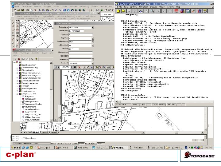
Dynamic Data-Model Datastructure and Applications generated from Interface-structure - INTERLIS (. ILI) - GML 3 - UML - Other modelling Tools -Topology -History (long Transactions) -Specific Feature-Types -3 D -Splines -Raster -Different coordinate systems -Different languages -Display-Model Advantages Flexible Data-Model Can be extendet very simple (by customer) RAD (rapid application development) Risks We need well-defined interface Too many different models Data modeling is not easy What can be done (not done) with the interface
 Use newest technology Create nice data-models –")
My wishes…. Make ONE specification (data-model, interface) Use newest technology Create nice data-models – Do not change it too often Work together with GIS-developers – Think about different GIS-implementations Force people to use this only data model

Thank you very much !
- Slides: 11