Condensation and Precipitation Growth of Cloud Drops Atmospheric


 collisions that join together small cloud droplets b)")

 to")


- Slides: 45
Condensation and Precipitation
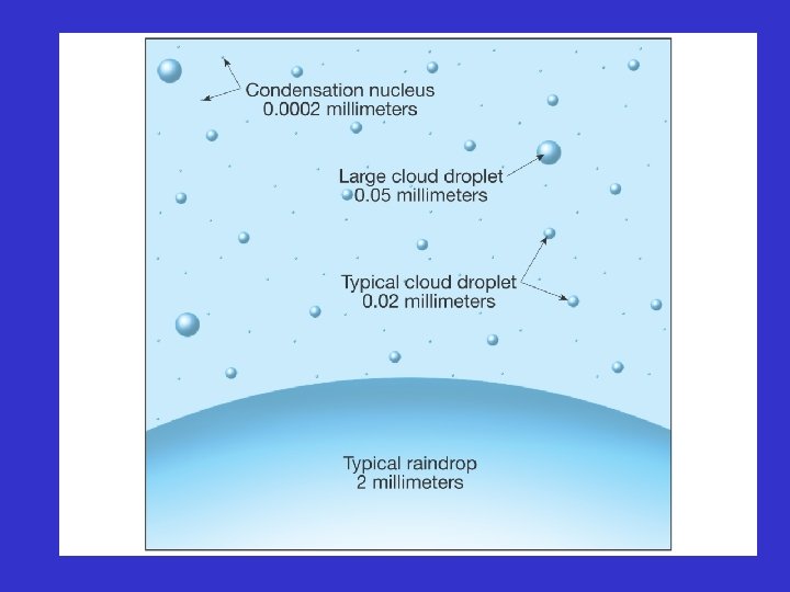
Growth of Cloud Drops Atmospheric vertical winds and eddies can keep small and light cloud droplets and condensation nuclei aloft. As the cloud droplets knock and join together, they grow larger and their weight increases, causing them to fall as precipitation. Figure 8. 1
Evaporation & Droplet Size Figure 8. 2 Water molecules more easily evaporate from a curved surface than a flat surface, which creates a greater concentration of molecules above the droplet, known as increased equilibrium vapor pressure.
Vapor Pressure & Saturation Smaller drops have greater curvature and require greater vapor pressure to keep water molecules from evaporating away. As the drop size increases, the required relative humidity (RH) for equilibrium decreases. If the required RH is exceeded, the drop will grow. Figure 8. 3
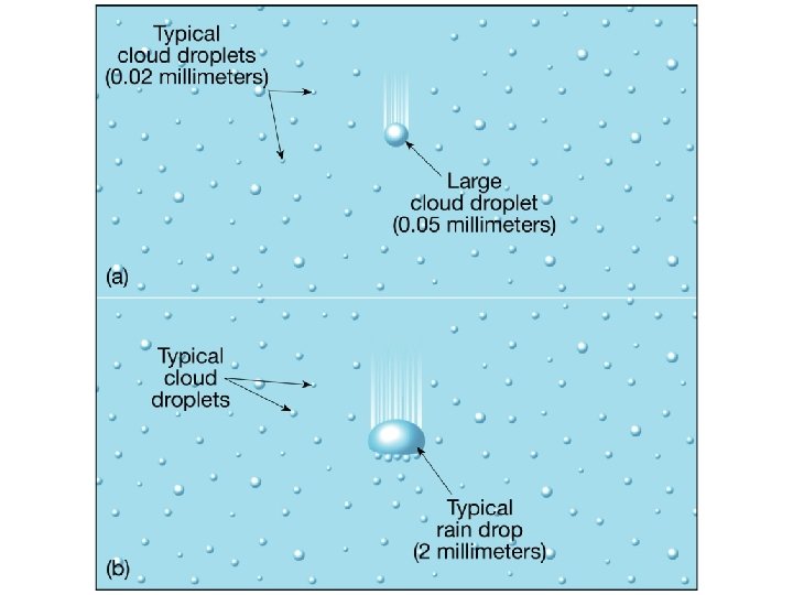
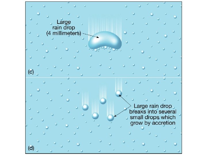
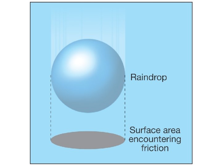
Collision & Coalescence Process Both a) collisions that join together small cloud droplets b) coalescence that attaches faster and larger droplets with smaller slower droplets work together to assemble nearly 1 million cloud droplets into a raindrop large enough to fall to earth. Figure 8. 4 A
Collision-Coalescence
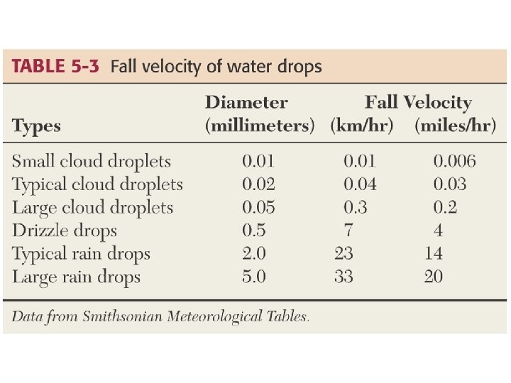
Warm Cloud Processes Collision and coalescence operates in warm clouds (> 15° C) to produce rain, and is affected by the clouds liquid water content, droplet sizes, cloud thickness, updrafts, and drop electrical charges. Figure 8. 5
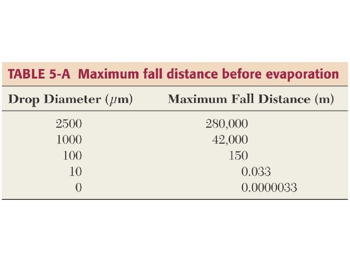
Evaporating Rain falling into low humidity air below will cause the drops to decrease in size, possibly evaporating into streaks of dry air as in this virga.
Fall streaks & Sublimation Ice crystals in cirrus clouds that fall and sublimate into drier air, fall streaks are produced that indicate wind speed and direction. Figure 8. 15 This is similar to rain evaporating in a virga.
Bergeron Process
Ice Crystal Process Cold clouds may drop below – 40° C before small droplets freeze into ice embryos that can serve as condensation nuclei. Figure 8. 6 At very low temperatures, vapor can also condense as ice onto nuclei formed by: a) deposition b) freezing c) contact, primarily in the glaciated region of the cloud.
Molecules from Water to Ice Figure 8. 8 Ice crystals have lower saturation vapor pressures than liquid droplets, creating a gradient of high to low water molecules from liquid to ice that encourages ice growth. This growth is critical to the icecrystal precipitation process. Figure 8. 9
Ice Particle Changes As ice crystals fall and collide with super cooled drops, they get bigger by accretion. Falling icy matter is called graupel, and aggregation describes the joining of two ice crystals into snowflakes. Figure 8. 10 A
Ice Crystal Growth Ice crystal growth is the dominant cause of precipitation in nimobstratus and cumulonimbus clouds, both of which have lower liquid content than warm-layered clouds such as stratus. Figure 8. 12
Snowflakes & Snowfall Figure 8. 17 Figure 8. 18 Snowflakes are crystalline structures that can have plate, column, dendrite, or needle forms. Air temperature and humidity determine crystal form, and dendrite is the most common habit.
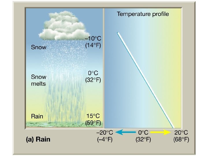
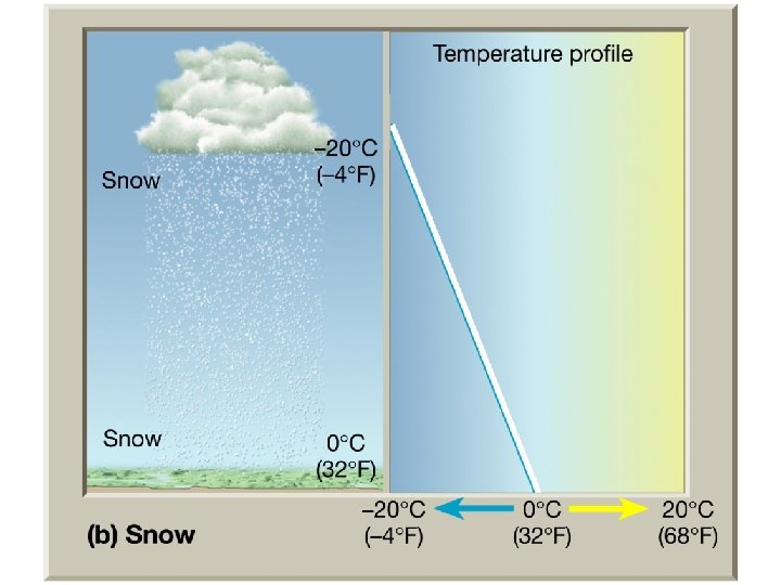
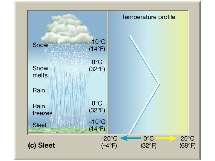
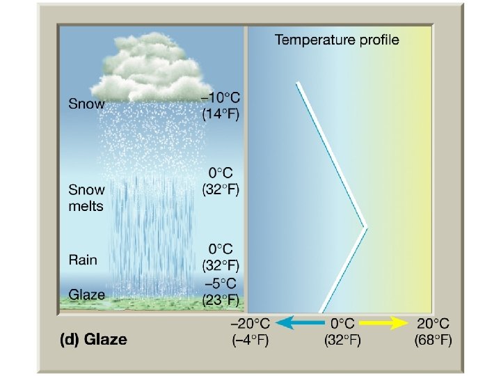
Sleet & Freezing Rain Environmental temperatures may reveal a warm zone between two freezing layers. Snow falling into the warm zone will melt and either a) fall as rain and refreeze on contact with the ground, or b) refreeze and fall as sleet. Figure 8. 19
Sleet & Freezing Rain - II Figure 8. 22 A Figure 8. 22 C Figure 8. 22 B Figure 8. 22 D Four vertical temperature profiles are shown to illustrate the phase change that a snowflake may experience in its path toward earth's surface.
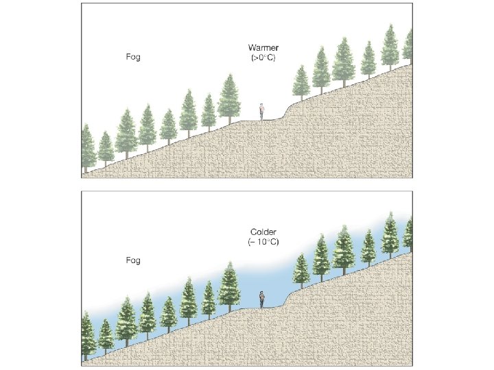
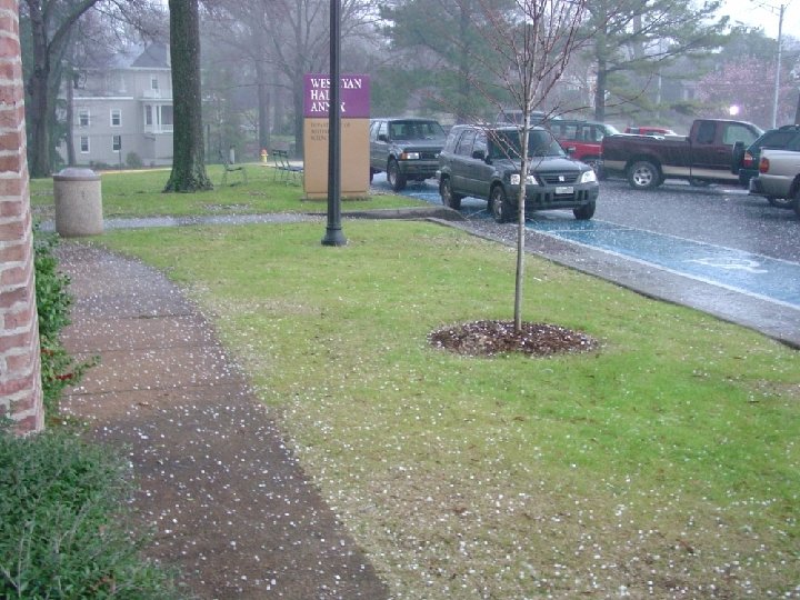
Rime & Freezing Rain Rime, a granular ice, accumulates when super cooled fog droplets touch a frozen surface. Figure 8. 20 Freezing rain creates incredible strain on branches and other structures, resulting in costly damages. Figure 8. 21
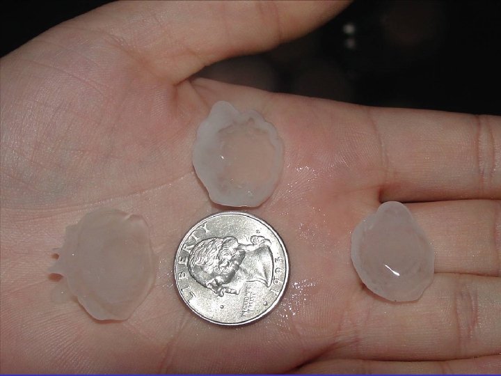
Snow Grain & Pellet Figure 8. 23 Flat and long snow grains fall as frozen drizzle, too small to bounce or shatter. Snow pellets are larger, and have a rounded layer of rimed ice that creates air bubbles and a bounce.
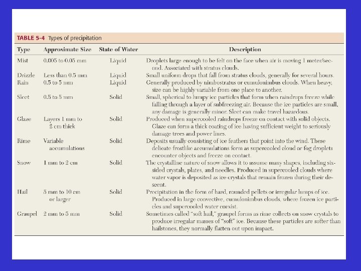
Formation of Precipitation Types
Formation of Sleet
Formation of Hail
Hailstones & Damage Figure 8. 25 Figure 8. 24 Updrafts in a towering cumulus cloud recirculate graupel through an accretion and freezing process that produces large heavy hailstones. Such storms cause regular property damage, but only 2 U. S. deaths in the 20 th Century.
Coffeyville Hailstone Figure 8. 26 A Figure 8. 26 B Regular and polarized light images of the 14 cm diameter hailstone that fell in Kansas in 1970. Hailstorms cause severe damage to crops and other structures.
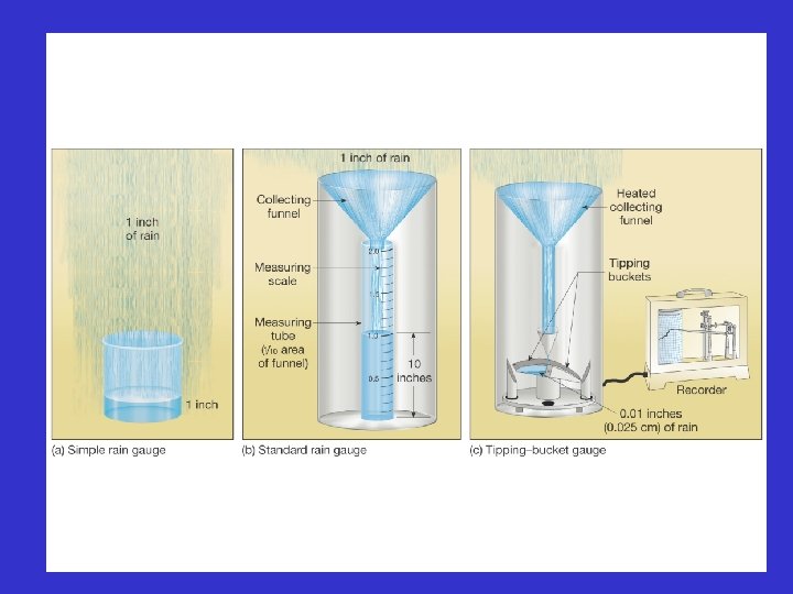
Measuring Rain w/ Standard Gauge Standard rain gauge uses a funnel to collect rain and then stores it in a narrower tube, so that the gauge detection is amplified 10 -fold. The 50 cm long tube, when filled, represents only 5 cm of total rainfall. Figure 8. 27
Measuring Rain w/ Recording Gauge Figure 8. 28 Tipping bucket and weighing rain gauges record precipitation rate at shorter time intervals, providing rain intensity data. Snow intensity can be measured with depth recorders, or accumulated totals with measuring sticks.
Radar Rainfall Figure 8. 29 A Figure 8. 29 B Doppler radar uses microwave transmission and reception to measure backscatter intensity, or reflectivity for large geographic areas. This signal is converted into maps of precipitation intensity, while phase shift data provide information on storm movement.
Cloud Seeding Figure 8. 11 Artificial seeding, such as Silver Iodide, and natural seeding, such as cirriform ice crystals, are available to increase the number of condensation nuclei and encourage precipitation.