Committee on Earth Observation Satellites Technology Tools Methods

Committee on Earth Observation Satellites Technology, Tools & Methods Used for Capacity Building at DLR Michael Bock & Dieter Hausamann Agenda Item 11 -4 CEOS 7 th Working Group for Capacity Building & Data Democracy (WGCap. D-7) Annual Meeting INPE São José dos Campos, Brazil 6 -8 th March, 2018

Capacity Building Activities Technology, Tools & Methods Portals & Projects by DLR Agency via German EO Program (BMWi) • SAREDU: SAREDU. dlr. de, will not be updated, all content moved to EO-College, • EO-College: EO-College. org, sustainable concept in cooperation with other agencies envisaged, several MOOCS by different parties in planning • SARbian, a compilation of freely available software for SAR Remote Sensing. • En. Map Portal: enmap. org, provides the free Enmap Toolbox, CB Material will be consolidated and distributed via EO-College Platform • FIS: Remote Sensing in Schools Portal: fis. uni-bonn. de Comprehensive learning portal on EO incl. research and analyses tools, useful for Entrance Level CB trainings too. A new portal will be launched soon.

Capacity Building Activities Technology, Tools & Methods Scientific Data Portals of DLR • TSX/TDX Scientifc Portals: terrasar. science. dlr. de tandemx-science. dlr. de, 90 m DEM to be released soon, Free Access for Capacity Buildung can be granted Copernicus Data Portals & Projects • CODE-DE: Code-De. de Sentinel data Portal and Cloud processing platform. • FP-CUP: DLR Agency leads European project on Copernicus User Uptake (Slide) • Copernicus Academy support the European Commission in bridging the gap between skills and Copernicus data use (DLR, Universities Jena, Bochum , Würzburg

Capacity Building Activities Technology, Tools & Methods SAR Trainings: • • • 2016 -17: Support to organize 3 WGCAPD SAR Trainings in Africa 10/2017: 3 day SAREDU Course at Stellenbosch Uni. in South Africa 9/2018: SAREDU Summerschool (use of CODE-DE cloud proc. in prep. ) Q 4/2018: Multilingual SAR Backscatter Mini- MOOC, Other Training 2018 -2019 tbd. Focus on E-Learning EO-College Other EO Trainings: see Presentation 30 -4 EAGLE Graduate Programm • applied EArth Observation and Geoanalysis of the Living Environment • International master program of DLR chair at University Würzburg Data Cube Trainings: • European data cube initiative is monitored, Future Trainings tbd. • Within project Big data cube Rasdaman datacube will be demonstrated

FIS – Remote Sensing in School Lessons Project: Earth Observation in School Lessons Interactive teaching materials for 5 STEM subjects Comprehensive learning portal on EO incl. research and analyses tools funded by DLR Update teaching material with Sentinel data New teaching material based on Mini-MOOCs, virtual and augmented reality ESA Mount Etna, IT, 16/03/2017 (Sentinel-2 A) Larsen C Antarctica, 19/01/2017 (Sentinel-1 A) Forest fires in California, USA, 15/12/2017 (Sentinel-3 A)

> Lecture > Author • Document > Date FP-CUP Framework Partnership Agreement on Copernicus User Uptake (FP-CUP) 1. 2. 3. 4. FPA contract expected April 2018 Consortium: 48 partners, 23 countries Budget ~20 Mio € (2018 -2021) Actions start 2018 Five Lines of Action 1. Information and Training 2. Building an Active User Dialogue 3. Developing Downstream Applications and Services 4. Piloting Downstream Applications and Services 5. Promoting National and Multi. National Innovation Actions DLR. de • Chart 6
 - Professionals (users in public/private sector) - Scientists (multipliers);")
Information and Training Target Group(s) - Professionals (users in public/private sector) - Scientists (multipliers); - Teachers and professors - EO professionals (developers) - Students (tertiary/secondary) Priority - New topics - Multi-national reach - National or lower levels Type of Actions (information) - User workshops Seminar series Information portals Publications Web-stories Videos Apps and games Social media Connecting domainspecific working procedures - … ü in national languages ü Specific national audiences ü Involve Copernicus Relays Type of Actions (training) - developing modules for university/cont’d education - courses for specific domains - online resources (software, data bases, curricula, MOOC) - programmes supporting the exchange of personnel among different institutions - … ü Involve Copernicus Academy DLR. de • Chart 7
 • Current duration: 01. 07. 2016")
CODE-DE: Copernicus Data and Exploitation Platform Deutschland (Germany) • Current duration: 01. 07. 2016 – 31. 03. 2019 (In discussion: operations until end 2019) • Phases: o Data Access: March 2017 o Processing 1: Nov 2017 (open/public solution) o Processing 2: May 2018 (dedicated 3 rd party solution + connection to Open Telekom Cloud) Contact: vanessa. keuck@dlr. de

CODE-DE – Access and distribution Sentinel Data, Copernicus Service Products and Tools Operation since March 2017 794. 000 Gi. B data volume (rolling archive) Geographical distribution of downloaded products (03. 2017 -01 -2018) 760 users 58. 000 downloaded products 19 open source tools (as of 31. 01. 2018) Origin of users

Way forward in CODE-DE • Successful installation of further CODE-DE components o Geoclient improvements (i. e. visualization of different band combinations) o Implementation of 3 rd party processing applications incl. coupling to Open Telekom Cloud (OTC) o Integration of Sentinel-3, Sentinel-5 P and RESA (Rapid Eye) o Integration of further tools o In discussion: use in the framework of special SAR trainings, (Sentinels and Terra. SAR/ Tan. DEM-X) • Routine operations (until end 2019 (tbd) • From 2019 onwards Hybrid DIAZ –CODE-DE solution possible

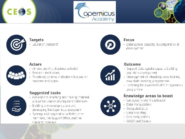
• The European Commission has launched two Networks to contribute on spreading awareness and knowledge about Copernicus across and outside the EU: o the Copernicus Relays o the Copernicus Academy • The Copernicus Academy Members will support the European Commission in: o bridging the gap between skills and data use o Enable the uptake of Copernicus data in new sectors The aim is to o foster the development of interdisciplinary masters and educational classes, o Skills boosting programmes for vocational training, industryuniversity traineeships and the creation of spin-offs. •

• Die Satellitenmission En. MAP • Dr. Stefanie Schrader Das En. MAP Use Preparation program Program objectives: • Scientific exploration • Support scientist by developmengt and analysing • New appication areas • Raise Awareness form Enmap • Fast data access • Support international cooperations • Synergien with other Mission contact stefanie. schrader@dlr. de DLR. de • Folie 13

En. MAP Box Software for Prozessing and Analysing of hyperspecztral data • Algorithms for: Agriculture, Forestry, Ecosystems, Geology water and Atmospheric correction • open source Software • QGIS plugin available (Beta-Version) • Download: www. enmap. org/? q=enma pbox

• Die Satellitenmission En. MAP • Dr. Stefanie Schrader En. MAP – Education and Training • Summerschools & workshops • Tutorials, Fieldguides, • Tools for En. MAP Box • En. MAP Ph. D Programm o Mehr als 30 PHD students till 2010
- Slides: 15