
COLLIER COUNTY COASTAL STORM RISK MANAGEMENT FEASIBILITY STUDY
COLLIER COUNTY COASTAL STORM RISK MANAGEMENT FEASIBILITY STUDY ALTERNATIVES MILESTONE MEETING (AMM) 255 255 237 237 217 217 200 200 0 163 163 131 132 122 Norfolk District 239 65 53 80 119 27 252 174. 59 110 135 120 112 92 56 Susan Conner Chief, Planning and Policy Branch Daniel Hughes Chief, Planning Resources Section Date: 11 January 2019 “The views, opinions and findings contained in this report are those of the authors(s) and should not be construed as an official Department of the Army position, policy or decision, unless so designated by other official documentation. ” 62 102 130 102 56 48 130 120 111
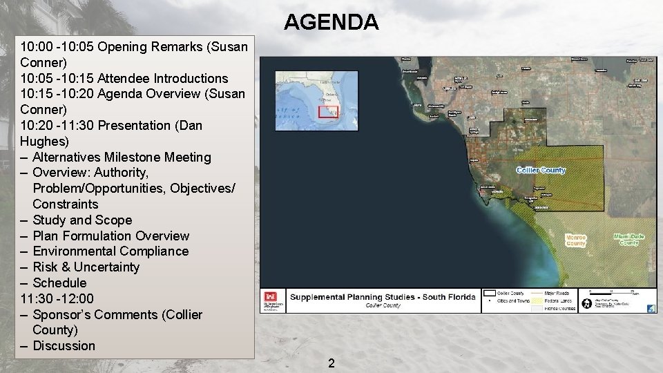
AGENDA 10: 00 -10: 05 Opening Remarks (Susan Conner) 10: 05 -10: 15 Attendee Introductions 10: 15 -10: 20 Agenda Overview (Susan Conner) 10: 20 -11: 30 Presentation (Dan Hughes) – Alternatives Milestone Meeting – Overview: Authority, Problem/Opportunities, Objectives/ Constraints – Study and Scope – Plan Formulation Overview – Environmental Compliance – Risk & Uncertainty – Schedule 11: 30 -12: 00 – Sponsor’s Comments (Collier County) – Discussion 2
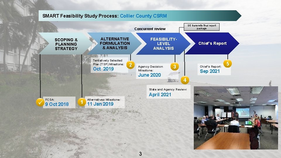
SMART Feasibility Study Process: Collier County CSRM DE transmits final report package Concurrent review SCOPING & PLANNING STRATEGY ALTERNATIVE FORMULATION & ANALYSIS Tentatively Selected Plan (TSP) Milestone: Oct 2019 2 FEASIBILITYLEVEL ANALYSIS Agency Decision Milestone: June 2020 Chief’s Report 3 Chief’s Report: Sep 2021 4 State and Agency Review: April 2021 FCSA: ü 9 Oct 2018 Alternatives Milestone: 1 11 Jan 2019 3 5
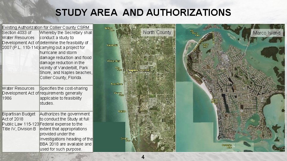
STUDY AREA AND AUTHORIZATIONS Existing Authorization for Collier County CSRM Section 4033 of Whereby the Secretary shall Water Resources conduct a study to Development Act of determine the feasibility of 2007 (P. L. 110 -114) carrying out a project for hurricane and storm damage reduction and flood damage reduction in the vicinity of Vanderbilt, Park Shore, and Naples beaches, Collier County, Florida. North County Water Resources Specifies the cost-sharing Development Act of requirements generally 1986 applicable to feasibility studies. Bipartisan Budget Authorizes the government Act of 2018 to conduct the Study at full Public Law 115 -123 Federal expense to the Title IV, Division B extent that appropriations provided under the Investigations heading of the BBA 2018 are available and used for such purpose. 4 Marco Island
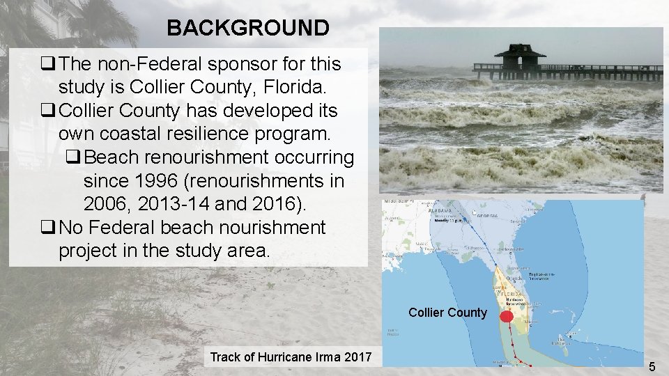
BACKGROUND q The non-Federal sponsor for this study is Collier County, Florida. q Collier County has developed its own coastal resilience program. q Beach renourishment occurring since 1996 (renourishments in 2006, 2013 -14 and 2016). q No Federal beach nourishment project in the study area. Collier County Track of Hurricane Irma 2017 5
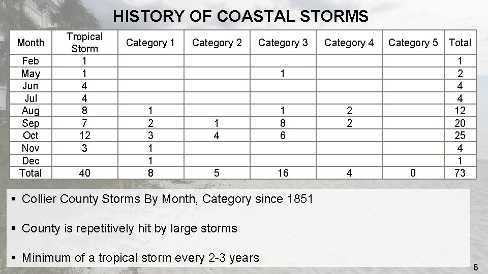
HISTORY OF COASTAL STORMS Month Feb May Jun Jul Aug Sep Oct Nov Dec Total Tropical Storm 1 1 4 4 8 7 12 3 40 Category 1 Category 2 Category 3 Category 4 Category 5 Total 1 2 3 1 1 8 1 4 5 1 1 8 6 16 2 2 4 0 1 2 4 4 12 20 25 4 1 73 § Collier County Storms By Month, Category since 1851 § County is repetitively hit by large storms § Minimum of a tropical storm every 2 -3 years 6
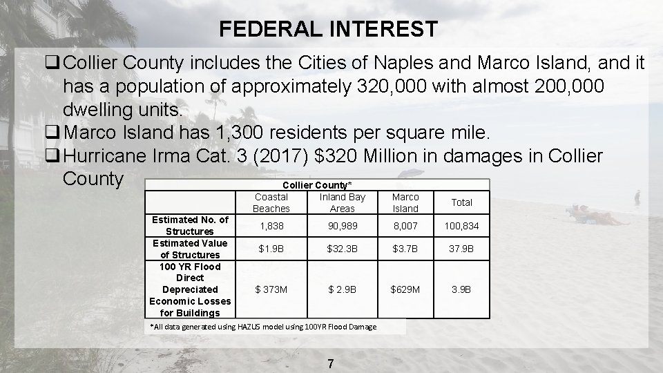
FEDERAL INTEREST q Collier County includes the Cities of Naples and Marco Island, and it has a population of approximately 320, 000 with almost 200, 000 dwelling units. q Marco Island has 1, 300 residents per square mile. q Hurricane Irma Cat. 3 (2017) $320 Million in damages in Collier County* Estimated No. of Structures Estimated Value of Structures 100 YR Flood Direct Depreciated Economic Losses for Buildings Coastal Beaches Inland Bay Areas Marco Island Total 1, 838 90, 989 8, 007 100, 834 $1. 9 B $32. 3 B $3. 7 B 37. 9 B $ 373 M $ 2. 9 B $629 M 3. 9 B *All data generated using HAZUS model using 100 YR Flood Damage 7
STUDY PURPOSE AND SCOPE q The study will develop and evaluate coastal storm risk management measures for the North County (includes City of Naples) and Marco Island project areas. Project areas include both gulf-facing shorelines and inland bay areas. q These measures will be formulated to reduce risk to residents, industries, and businesses which are critical to the nation’s economy. q The long-term strategy for resilience in Collier County will be a layered approach that may include solutions executed by the NFS, other Federal agencies, the cities located with the County, and/or non-governmental organizations in addition to recommendations for implementation by USACE resulting from this feasibility study. q Approval Authority has been delegated to the MSC (NAD). q Environmental Impact Statement is proposed. 8
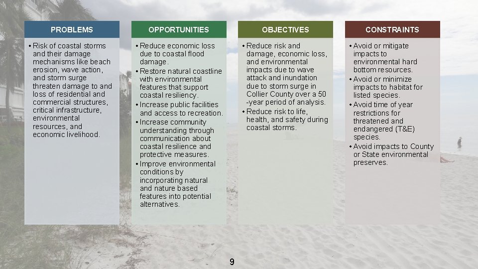
PROBLEMS OPPORTUNITIES OBJECTIVES CONSTRAINTS • Risk of coastal storms and their damage mechanisms like beach erosion, wave action, and storm surge threaten damage to and loss of residential and commercial structures, critical infrastructure, environmental resources, and economic livelihood. • Reduce economic loss due to coastal flood damage. • Restore natural coastline with environmental features that support coastal resiliency. • Increase public facilities and access to recreation. • Increase community understanding through communication about coastal resilience and protective measures. • Improve environmental conditions by incorporating natural and nature based features into potential alternatives. • Reduce risk and damage, economic loss, and environmental impacts due to wave attack and inundation due to storm surge in Collier County over a 50 -year period of analysis. • Reduce risk to life, health, and safety during coastal storms. • Avoid or mitigate impacts to environmental hard bottom resources. • Avoid or minimize impacts to habitat for listed species. • Avoid time of year restrictions for threatened and endangered (T&E) species. • Avoid impacts to County or State environmental preserves. 9
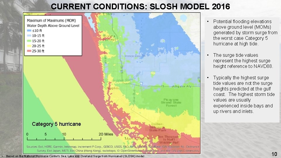
CURRENT CONDITIONS: SLOSH MODEL 2016 STORM SURGE RISK • Potential flooding elevations above ground level (MOMs) generated by storm surge from the worst case Category 5 hurricane at high tide. • The surge tide values represent the highest surge height reference to NAVD 88. • Typically the highest surge tide values are not the surge heights predicted at the gulf coast. The highest storm tide values are usually experienced inside bays and up rivers and inlets. Category 5 hurricane • Based on the National Hurricane Center's Sea, Lake and Overland Surge from Hurricanes (SLOSH) model 10
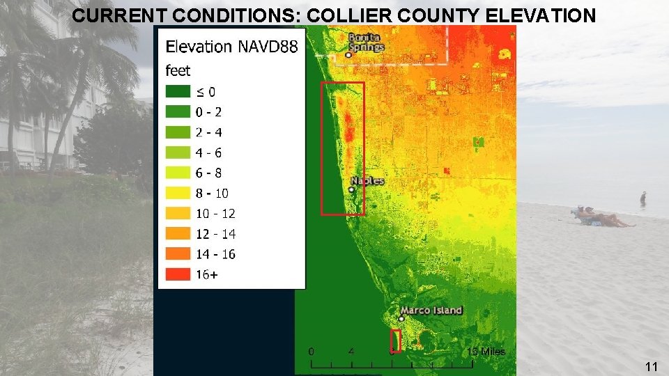
CURRENT CONDITIONS: COLLIER COUNTY ELEVATION 11
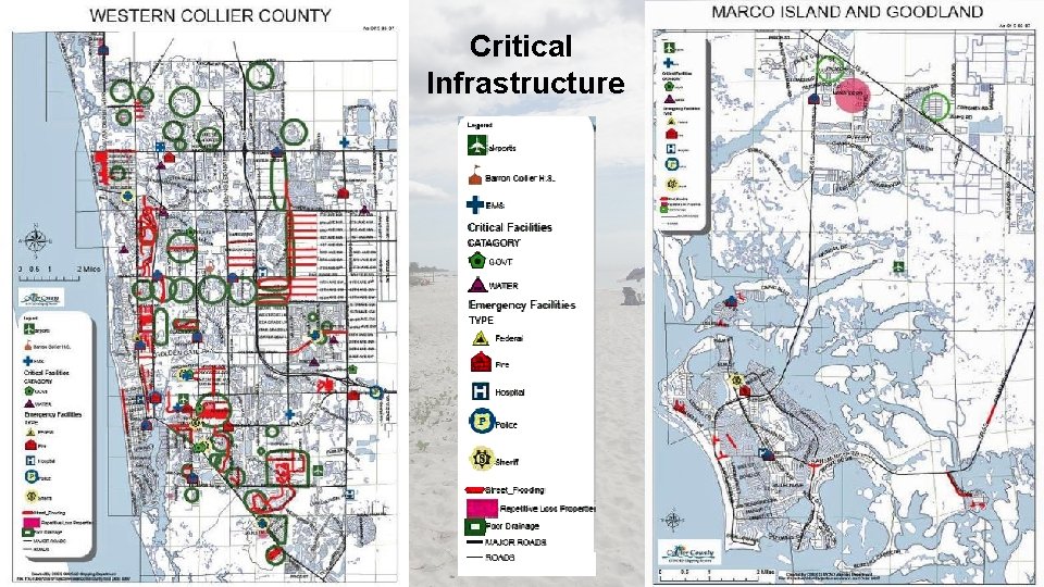
Critical Infrastructure 12
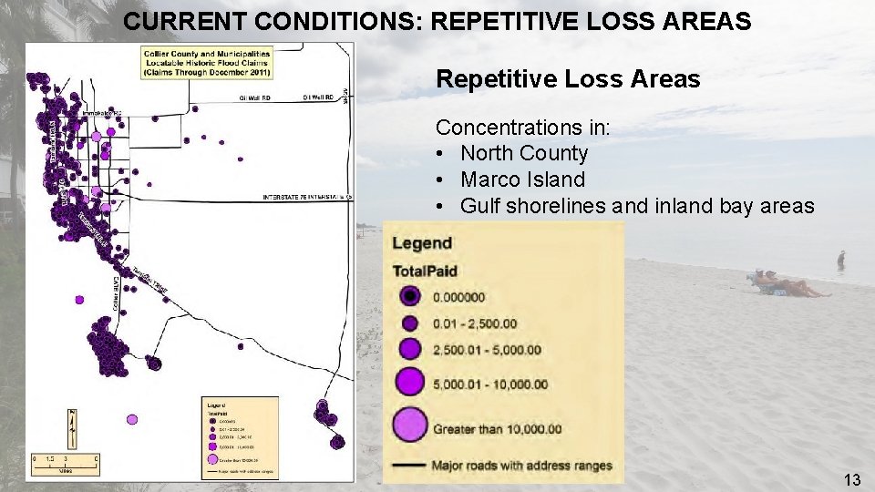
CURRENT CONDITIONS: REPETITIVE LOSS AREAS Repetitive Loss Areas Concentrations in: • North County • Marco Island • Gulf shorelines and inland bay areas 13
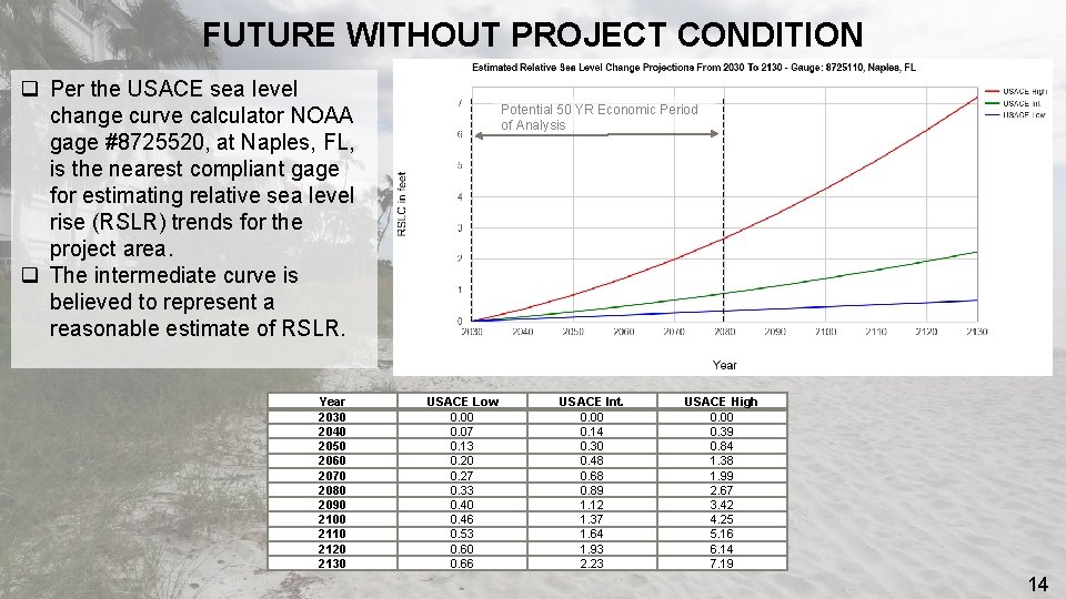
FUTURE WITHOUT PROJECT CONDITION q Per the USACE sea level change curve calculator NOAA gage #8725520, at Naples, FL, is the nearest compliant gage for estimating relative sea level rise (RSLR) trends for the project area. q The intermediate curve is believed to represent a reasonable estimate of RSLR. Year 2030 2040 2050 2060 2070 2080 2090 2100 2110 2120 2130 Potential 50 YR Economic Period of Analysis USACE Low 0. 00 0. 07 0. 13 0. 20 0. 27 0. 33 0. 40 0. 46 0. 53 0. 60 0. 66 USACE Int. 0. 00 0. 14 0. 30 0. 48 0. 68 0. 89 1. 12 1. 37 1. 64 1. 93 2. 23 USACE High 0. 00 0. 39 0. 84 1. 38 1. 99 2. 67 3. 42 4. 25 5. 16 6. 14 7. 19 14
FUTURE WITHOUT PROJECT CONDITION Quantitative Verification of the FWOP done by: q. Beach-fx evaluates beach erosion, physical storm impacts, and damages that occur from a storm passing a shore q. Calibrating the existing condition in G 2 CRM q Projecting potential suite of storms, sea level rise scenarios, wave characteristics, and inundation depths q Running the forecast through G 2 CRM to estimate anticipated damages to structures, contents, and vehicles 15
FUTURE WITHOUT PROJECT CONDITION q Population projections in Collier County show continued growth along the coastal areas q Storm intensity due to higher sea levels, and nuisance/sunny day flooding will increase damages in the study area throughout the period of analysis q Sea level is expected to rise over 1 foot within the next 50 years (USACE Intermediate Curve) q Projects that will be implemented by the non-Federal sponsor include: q Maintenance and renourishment of 7. 5 miles of shoreline along North County q Back Bay areas will remain vulnerable 16
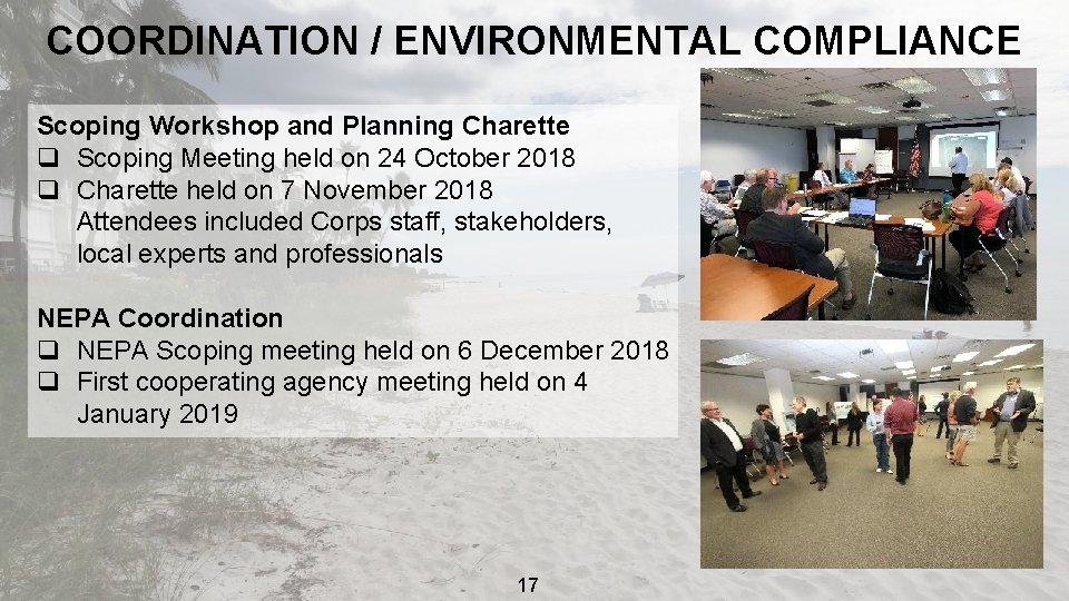
COORDINATION / ENVIRONMENTAL COMPLIANCE Scoping Workshop and Planning Charette q Scoping Meeting held on 24 October 2018 q Charette held on 7 November 2018 Attendees included Corps staff, stakeholders, local experts and professionals NEPA Coordination q NEPA Scoping meeting held on 6 December 2018 q First cooperating agency meeting held on 4 January 2019 17
SUMMARY OF SCOPING COMMENTS Three comments received as of 3 JAN 2019 • Concerns regarding erosion south of Doctors Pass and effectiveness of groins; suggests use of offshore breakwaters in problem areas • Worries about impacts on species that aren’t protected, what affects we’ll have on wetlands or marsh, ecological services benefits, and habitat • Distress over frequency and magnitude of Red Tide occurrences in vicinity of Park Shore beaches and the resulting effects of fish kill 18
COOPERATING AGENCIES q U. S. Environmental Protection Agency - Accepted q U. S. Coast Guard q National Oceanic and Atmospheric Administration - Accepted q Florida Department of Historic Resources q Florida Department of Environmental Protection q U. S. Fish and Wildlife Service - Declined q Federal Emergency Management Agency q Bureau of Ocean Energy Management – Accepted q Florida Department of Transportation 19
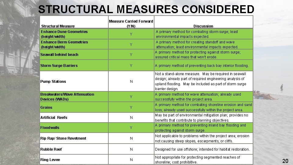
STRUCTURAL MEASURES CONSIDERED Structural Measure Enhance Dune Geometries (height/width) Enhance Berm Geometries (height/width) Measure Carried Forward (Y/N) Y Y Seawall behind beach Y Storm Surge Barriers Y Discussion A primary method for combating storm surge; least environmental impacts expected. A primary method for creating standoff and wave attenuation; least environmental impacts expected. A primary method for protecting against storm surge; assured critical mass that won’t erode. A primary method of preventing back bay interior flooding. Not a stand-alone measure. May be required in seawall design; already part of required engineering analysis of upland flooding. May be included as part of storm surge barrier design. A primary method for wave attenuation; already used successfully within the project area. A primary method for combating shoreline erosion and sand loss; already used successfully within the project area. May be part of environmental mitigation plan; provides no benefits that contribute to planning objectives. A primary method for preventing inland bay flooding and protecting against storm surge. Pump Stations N Breakwaters/Wave Attenuation Devices (WADs) Y Groins Y Artificial Reefs N Floodwalls Y Rip Rap/ Stone Revetment N Not applicable to problems within the project area; erosion not causing steep slopes, escarpments, or cliffs. Rubble Reef N Designed for use offshore; intended for habitat restoration. Ring Levee N Not appropriate for protecting segmented reaches of shoreline; cost prohibitive. 20
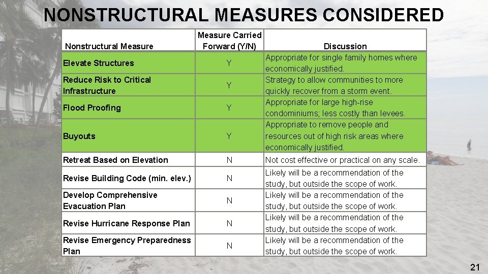
NONSTRUCTURAL MEASURES CONSIDERED Nonstructural Measure Carried Forward (Y/N) Elevate Structures Y Reduce Risk to Critical Infrastructure Y Flood Proofing Y Buyouts Y Retreat Based on Elevation N Revise Building Code (min. elev. ) N Develop Comprehensive Evacuation Plan N Revise Hurricane Response Plan N Revise Emergency Preparedness Plan N Discussion Appropriate for single family homes where economically justified. Strategy to allow communities to more quickly recover from a storm event. Appropriate for large high-rise condominiums; less costly than levees. Appropriate to remove people and resources out of high risk areas where economically justified. Not cost effective or practical on any scale. Likely will be a recommendation of the study, but outside the scope of work. 21
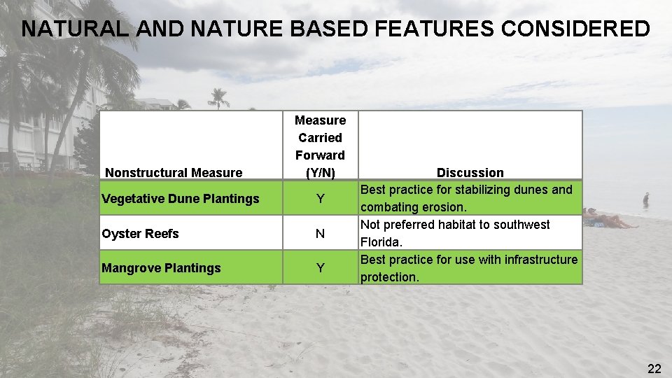
NATURAL AND NATURE BASED FEATURES CONSIDERED Nonstructural Measure Carried Forward (Y/N) Vegetative Dune Plantings Y Oyster Reefs N Mangrove Plantings Y Discussion Best practice for stabilizing dunes and combating erosion. Not preferred habitat to southwest Florida. Best practice for use with infrastructure protection. 22
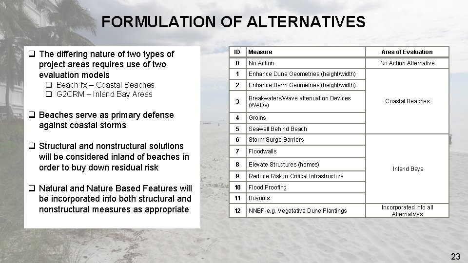
FORMULATION OF ALTERNATIVES q The differing nature of two types of project areas requires use of two evaluation models q Beach-fx – Coastal Beaches q G 2 CRM – Inland Bay Areas q Beaches serve as primary defense against coastal storms q Structural and nonstructural solutions will be considered inland of beaches in order to buy down residual risk q Natural and Nature Based Features will be incorporated into both structural and nonstructural measures as appropriate ID Measure Area of Evaluation 0 No Action Alternative 1 Enhance Dune Geometries (height/width) 2 Enhance Berm Geometries (height/width) 3 Breakwaters/Wave attenuation Devices (WADs) 4 Groins 5 Seawall Behind Beach 6 Storm Surge Barriers 7 Floodwalls 8 Elevate Structures (homes) 9 Reduce Risk to Critical Infrastructure 10 Flood Proofing 11 Buyouts 12 NNBF-e. g. Vegetative Dune Plantings Coastal Beaches Inland Bays Incorporated into all Alternatives 23
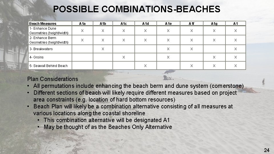
POSSIBLE COMBINATIONS-BEACHES Beach Measures 1 - Enhance Dune Geometries (height/width) 2 - Enhance Berm Geometries (height/width) 3 - Breakwaters 4 - Groins 5 - Seawall Behind Beach A 1 a A 1 b A 1 c A 1 d A 1 e A 1 f A 1 g A 1 X X X X X X X Plan Considerations • All permutations include enhancing the beach berm and dune system (cornerstone) • Different sections of beach will likely require different measures based on project area constraints (e. g. location of hard bottom resources) • Beach Plan will likely be a combination alternative consisting of all measures at various locations along the coastal shoreline • This combination alternative will be designated A 1 • May be thought of as the Beaches Only Alternative 24
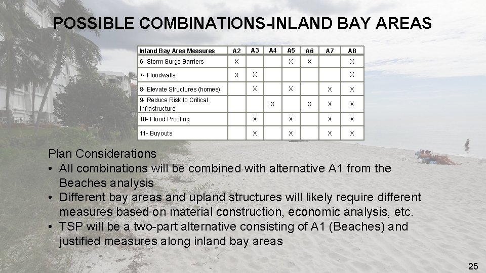
POSSIBLE COMBINATIONS-INLAND BAY AREAS Inland Bay Area Measures A 2 6 - Storm Surge Barriers X 7 - Floodwalls X 8 - Elevate Structures (homes) A 3 A 4 A 5 A 6 X X A 7 X X 9 - Reduce Risk to Critical Infrastructure A 8 X X X X 10 - Flood Proofing X X 11 - Buyouts X X Plan Considerations • All combinations will be combined with alternative A 1 from the Beaches analysis • Different bay areas and upland structures will likely require different measures based on material construction, economic analysis, etc. • TSP will be a two-part alternative consisting of A 1 (Beaches) and justified measures along inland bay areas 25
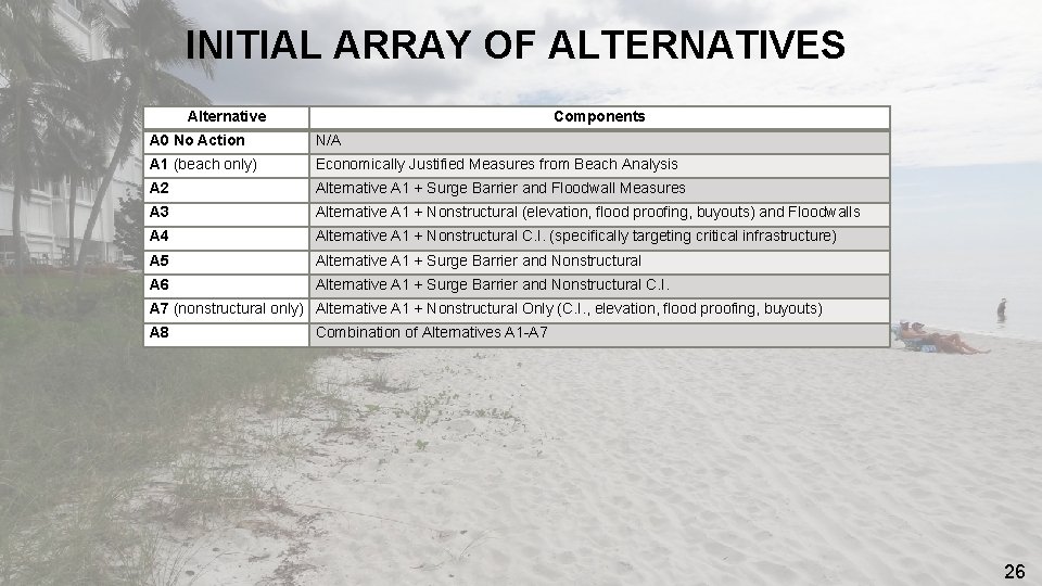
INITIAL ARRAY OF ALTERNATIVES Alternative Components A 0 No Action N/A A 1 (beach only) Economically Justified Measures from Beach Analysis A 2 Alternative A 1 + Surge Barrier and Floodwall Measures A 3 Alternative A 1 + Nonstructural (elevation, flood proofing, buyouts) and Floodwalls A 4 Alternative A 1 + Nonstructural C. I. (specifically targeting critical infrastructure) A 5 Alternative A 1 + Surge Barrier and Nonstructural A 6 Alternative A 1 + Surge Barrier and Nonstructural C. I. A 7 (nonstructural only) Alternative A 1 + Nonstructural Only (C. I. , elevation, flood proofing, buyouts) A 8 Combination of Alternatives A 1 -A 7 26
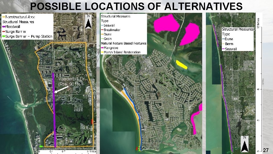
POSSIBLE LOCATIONS OF ALTERNATIVES Vanderbilt Dr. (Rte. 901) 27
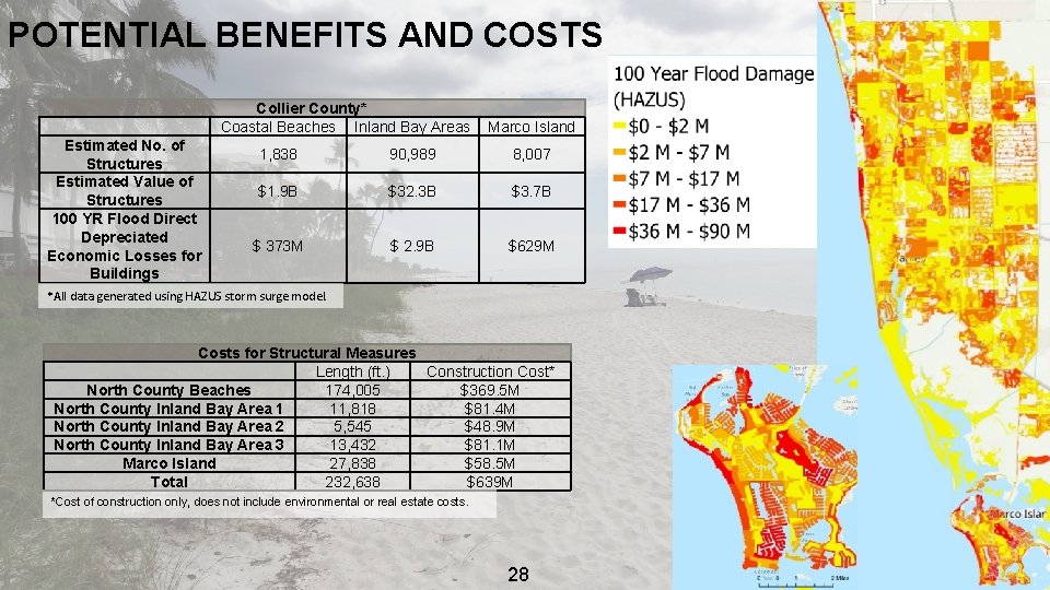
POTENTIAL BENEFITS AND COSTS Collier County* Coastal Beaches Inland Bay Areas Estimated No. of Structures Estimated Value of Structures 100 YR Flood Direct Depreciated Economic Losses for Buildings Marco Island 1, 838 90, 989 8, 007 $1. 9 B $32. 3 B $3. 7 B $ 373 M $ 2. 9 B $629 M *All data generated using HAZUS storm surge model. Costs for Structural Measures Length (ft. ) Construction Cost* North County Beaches 174, 005 $369. 5 M North County Inland Bay Area 1 11, 818 $81. 4 M North County Inland Bay Area 2 5, 545 $48. 9 M North County Inland Bay Area 3 13, 432 $81. 1 M Marco Island 27, 838 $58. 5 M Total 232, 638 $639 M *Cost of construction only, does not include environmental or real estate costs. 28
RECREATION BENEFITS • Contract for Economic Recreational Benefit Analysis using the Contingent Valuation and Travel Cost method • Shared with four other Supplemental projects with similar recreational analysis requirements • Contract includes writing of survey instrument (to be coordinated and approved through OMB), data collection and analysis, development of econometric model, and reporting of model/resulting recreation values estimates • There are over 1. 7 million annual visitors to Collier County 29
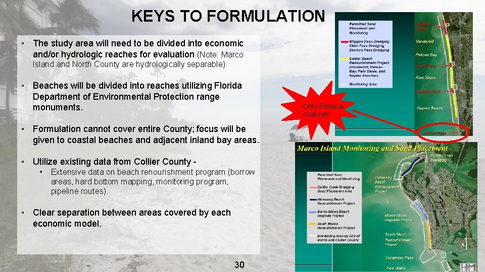
KEYS TO FORMULATION • The study area will need to be divided into economic and/or hydrologic reaches for evaluation (Note: Marco Island North County are hydrologically separable). • Beaches will be divided into reaches utilizing Florida Department of Environmental Protection range monuments. Only Federal channel! • Formulation cannot cover entire County; focus will be given to coastal beaches and adjacent inland bay areas. • Utilize existing data from Collier County • Extensive data on beach renourishment program (borrow areas, hard bottom mapping, monitoring program, pipeline routes). • Clear separation between areas covered by each economic model. 30 20
RESIDUAL RISK • Generally the elevation across Collier County is very lowØ The level of protection against maximum flood elevations for a Category 5 storm will likely be very low • Sections of public beach or beaches where adequate public access cannot be established will continue to be more vulnerable than areas where the beach profile has been reconstructed • Areas within and directly adjacent to Coastal Barrier Resource Act (CBRA) zones will not benefit from reduced risk of coastal storms • State and County nature preserves will also remain vulnerable 31
INITIAL ARRAY KEY ASSUMPTIONS q The measures comprising the alternatives justified along coastal beaches will be considered in the future without project conditions when modeling measures on inland bay areas. q Natural and Nature Based Features will be incorporated into project alternatives where applicable. 32
TSP SELECTION CRITERIA q Damages prevented/reduced q Estimated cost q Life safety benefits q Environmental impact or improvement q Regional Economic Development benefits/impact q Recreation benefits q Other Social Effects 33
ENVIRONMENTAL COMPLIANCE q Preparation of an EIS anticipated – initial NEPA scoping conducted; NOI to be published following Alternatives Milestone Meeting q Cooperating and participating agency invitation letters sent q Conducted initial 90 -day Interagency Cooperation Meeting q Portions of study area located in designated protected coastal barrier zone per the Coastal Barrier Resources Act q Fish and Wildlife Coordination Act will be addressed with NEPA process per a Memorandum of Agreement with FWS q Magnuson-Stevens Fishery Conservation Act – EFH Assessment being prepared q National Historic Preservation Act, Section 106 compliance – Programmatic Agreement anticipated First Cooperating Agency Meeting occurred for 4 January 2019. 34
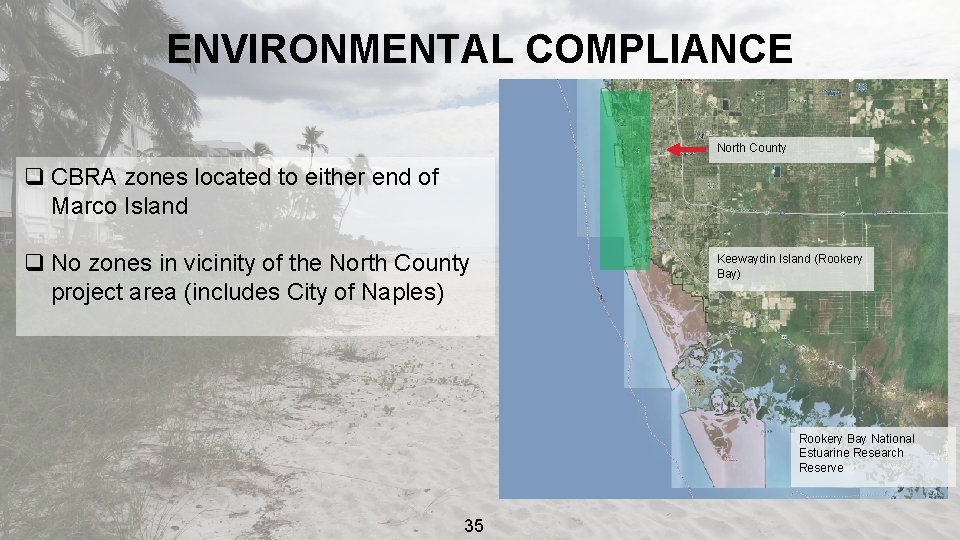
ENVIRONMENTAL COMPLIANCE North County q CBRA zones located to either end of Marco Island q No zones in vicinity of the North County project area (includes City of Naples) Keewaydin Island (Rookery Bay) Rookery Bay National Estuarine Research Reserve 35
THREATENED AND ENDANGERED SPECIES q Threatened and Endangered Species under the protection of Section 7 of the Endangered Species Act: q 8 mammal species- also under protection of the Marine Mammal Protection Act q 6 fish species q 7 corals q 2 listed plants species q 9 birds q 4 sea turtles; 1 snake (eastern Indigo snake); American crocodile and American Alligator q 3 butterflies q Seven critical habitats in study area 36
RISK AND UNCERTAINTY Engineering q Material quantities; a new borrow source may be needed - Medium risk q Soil borings may be deferred to PED - Medium risk q G 2 CRM new inputs required - Medium risk Plan Formulation q. Expansion of scope to include inland bay areas has increased study complexity putting TSP milestone at risk - High risk 37
RISK AND UNCERTAINTY Economics q New G 2 CRM model - Medium risk Environmental/Cultural Resources q. Potential hard bottom limits alternatives - Medium risk q. Water quality modeling will be conducted to assess potential water quality effects - Medium risk q. Phase I Archeological Survey likely required to assess potential effects to cultural resources; there are previous surveys - Low risk 38
POLICY COMPLIANCE • Have the 1002 letters been sent to sponsors- Sent via certified mail • Funding stream developed for each- $400 K 2018, $1. 6 M 2019, $600 K 2020, $400 K 2021 • Compliance memo needed- No • Review plan developed- Submitted to NAD • Draft PMP developed • NEPA scoping comments compilation- Yes, deadline is 10 January (no major comments at this time) • FWS Coordination: PAL, CAR, Section 7 expectations- Yes, coordination and participation letters have been sent, formal ESA consult expected 39
PATH TO TSP • • • • n o i l l mi 6. : $1 to be 9 1 FY nding in fu ated g obli Complete the structure inventory G 2 CRM/Beach-fx modeling of FWOP condition ATR of G 2 CRM/Beach-fx FWOP runs Identification of structures for nonstructural measures Refine structural and NNBF measures Development of ROM costs for each alternative Comparison of FWOP damages to ROM costs for alternatives IPR to discuss early results and screening to final array (~3 months after AMM) G 2 CRM/Beach-fx modeling of with project alternatives Refine costs and economic modeling to identify NED Plan IPR to discuss early NED Plan, Coordinate with NFS on NED plan, identify if LPP may be requested Cultural and environmental resource surveys Recreational benefits analysis study Real estate depreciated valuation of structure inventory 40
STUDY MILESTONE SCHEDULE Signing of Feasibility Cost Share Agreement (CW 130) 10 Oct 2018 (A) Alternatives Milestone (CW 261) 11 Jan 2019 (S) IPR-Final Array of Alternatives April 2019 IPR-Preliminary Economics August 2019 Tentatively Selected Plan Milestone (CW 262) Oct 2019 (S) Release of Draft Study for Concurrent Reviews (CW 250) Dec 2019 (S) Agency Decision Milestone (CW 263) Jun 2020 (S) Submit Final Report Package to Vertical Team (CW 160) April 2021 (S) Final Review Complete (CW 170) Aug 2021 (S) Signed Chief’s Report (CW 270) Sept 2021 (S) 41
SPONSOR’S COMMENTS COLLIER COUNTY, FLORIDA 42
DISCUSSION 43
- Slides: 43