Cold Front Indicators Lines of cumulus clouds approaching


- Slides: 19
Cold Front Indicators • Lines of cumulus clouds approaching from the west or northwest • Large clouds of dust can precede the arrival of a cold front • Shift in winds from the southeast, south, to southwest, and increase in velocity • Winds will be strongest, erratic, and gusty as the front approaches. • Winds will continue to shift as the front passes, generally resulting in strong, gusty, cool winds out of the west and northwest.
Dangers Associated with Cold Fronts • Wind direction will abruptly change • Strong southerly winds ahead of front will drive the fire head to the north or northeast • Winds shifting to west or northwest after front passes will drive fire head to the east or south east. • Rapid drop in relative humidity within 24 hours of front passage.
Visual Indicators of Thunderstorms • • Tall building cumulus clouds Dark flat base Virga or rain falling from cloud bottom Ice crystal top usually in anvil shape with fuzzy appearance. • Cauliflower cloud appearance
Why Thunderstorms are Dangerous • Produces strong gusty surface winds affecting direction of fire spread • Downdraft winds will be erratic but always from the thunderstorm • Thunderstorms also produce lightning which can be dangerous
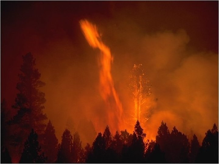
Fire Whirles Generated by intense fires can pick up large burning embers and toss them across fire lines causing spot fires
Fuel Indicators of Extreme Fire Behavior • Unusually dry fuels • Large amount of light fuel (shrubs, grass, needles) • Fuels exposed to direct sunlight • Fuels dried by prolonged drought • Ladder fuels that allow a surface fire to move into the crowns of shrubs or trees • Crown foliage dried by surface fire • Concentration of snags
Topographic Indicators of Extreme Fire Behavior • Steep slopes • Chutes, saddles, and box canyons which provide conditions for “chimney effect. ” • Narrow canyons may increase fire spread by radiant heat and spotting • Fire located on cape which can be impacted by sea breeze from three directions
Weather Indicators of Extreme Fire Behavior • Strong wind • Sudden changes in wind direction and velocity due to weather • High fast moving clouds may indicate unusual surface winds • Unexpected calm may indicate wind shift • Thunderstorms above or close to the fire • Unusually high temperature and low relative humidity • Dust devils and whirl winds developing • Bent Smoke Column
General Indicators of Extreme Fire Behavior • Keep an eye on the smoke column. Indicates direction of fire spread, spot fire locations, & changes in fire intensity • Many simultaneous fires starting or smoldering fires beginning to pick-up in intensity • Fire begins to torch small groups of trees or shrubs • Frequent spot fires occurring • Firewhirls beginning to develop inside main fire • Crown fires
Review
Review