Coastal Wind Energy Study Components Wind resource evaluation

 G. Lackmann (RENCI, NC")


 S. Fegley")


 Aerial photograph of a flock (a “raft”) of 20, 000")
")

,")


 D. Ames (Geologic Sciences, East Carolina) Sound")


- Slides: 40
Coastal Wind Energy Study Components Wind resource evaluation Ecological impacts, synergies, use conflicts Foundation concepts Geologic framework Utility transmission infrastructure Utility-related statutory and regulatory barriers Legal framework, issues, and policy concerns Carbon reduction Preliminary economic analysis Presentation includes summaries of some components.
Wind Resource Evaluation H. Seim (Marine Sciences, UNC Chapel Hill) G. Lackmann (RENCI, NC State) Compare existing wind power estimates from AWS Truewind with available low-level (largely 10 meter) wind observations Extrapolate low level winds to height – use NC SOW meteorological tower data to examine power-law and log layer fits Collect new observations with a sodar wind profiler Initiate archive and evaluation of regional wind models being run by NC Climatology Office and RENCI
Observations Used in the Study
Vertical Extrapolation required to estimate winds at turbine height Must account for varying roughness of lower boundary. Used two simple techniques – log layer and power law fits Assess validity of extrapolation techniques using existing vertical wind profile observations
Power-law vs log layer extrapolation
Log-layer to AWS Truewind Comparison
Log-layer to AWS Truewind Comparison
Power law winds– better offshore
Wind Power Class
Capacity Factor Power generation is dependent on the generator used Simple but realistic approach is to use power curve for common wind turbine to convert wind speed to power Power curves for 3 -3. 6 MW turbines all similar – kickin speed of 3 -5 m/s, rated power at 15 m/s, no output above 25 m/s. Capacity factor is simply the average output from a generator divided by its maximum output, expressed as a percentage. Used measured over-water wind records to estimate capacity factor
Capacity Factor Map
Ecological impacts, synergies, use conflicts C. Peterson (Marine Sciences, UNC Chapel Hill) S. Fegley (Marine Sciences, UNC Chapel Hill) Joan Meiners (Marine Sciences, UNC Chapel Hill) Risk to birds, bats, and butterflies and the loss or fragmentation of their terrestrial habitat Risk to marine mammals, sea turtles, fish, and bottom-dwelling invertebrates Synergies with other ecosystem services Conflicts with military, mining, cultural, and ocean dumping uses
Procedure for estimating risk Interview experts, managers, bird watchers, fishermen, and duck hunters: - 54 in-person interviews - 5 phone interviews Review relevant literature: - 21 environmental assessments - 21 government reports - 40 peer-reviewed articles - 14 unpublished manuscripts Accumulate and organize pertinent information: - distributions and temporal patterns of organisms - possible presence of endangered, threatened, or species of concern - specific behavioral responses to structures, noises, and visual cues - distribution of fishery habitat and fishing activities Estimation of risk: - examine accumulated information for patterns and specific concerns - use general ecological data and paradigms to reduce uncertainty - consult with experts again on preliminary assessments
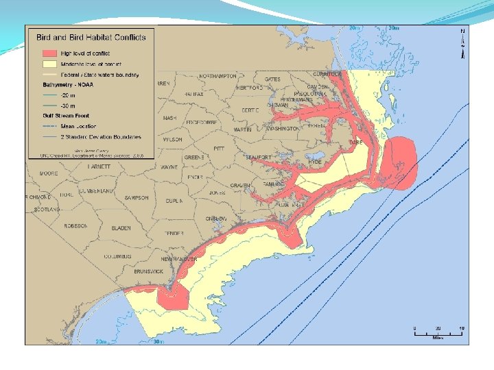
Bird and Bat Risk Distribution Risk assessment – combines abundance and behavior Mortality risk from encounter with blades Turbine avoidance increases fitness risks from loss of foraging habitat or by inducing longer flight paths (especially for overwintering ducks) Scott Hecker, National Audubon Al Perry
Behavioral responses (an example) Aerial photograph of a flock (a “raft”) of 20, 000 common eiders – photograph by Simon Perkins, Mass Audubon Compilation of radar tracks for common eiders and geese flying near and through an offshore, Danish wind mill farm (individual mills are represented by red dots – Desholm and Kahlert 2005). These results are controversial; the wind mills interfere with the radar used to document flight paths.
Bird and Bat Risk Distribution Birds at risk Passerines during nocturnal, seasonal migrations (songbirds) Threatened and Endangered, plus declining, species (piping plover, red knot, other migrating shorebird species, and roseate tern) during fall/spring migrations and summer residence Large-bodied, low-flying, slow fliers (pelicans) True pelagic seabirds (albatross) – Gulf Stream risks Bats at risk – migrating insectivorous species
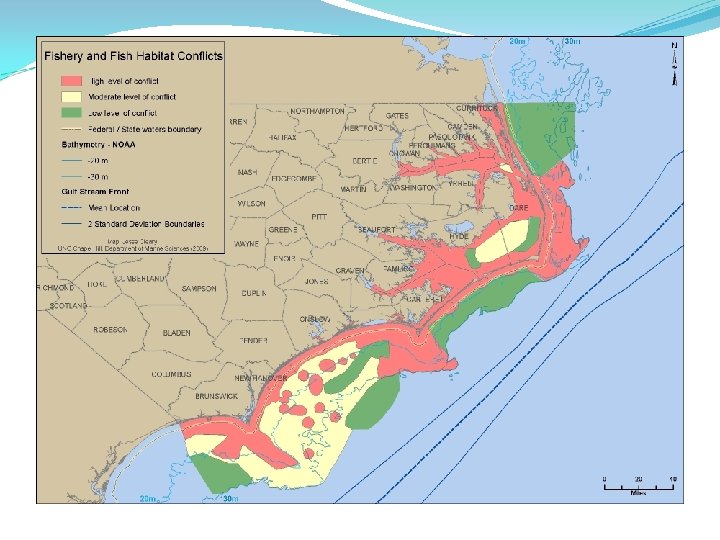
Critical Fish Habitats and Fishing Uses Primary, secondary nurseries, migration paths, strategic habitats, submerged aquatic vegetation, shell bottom, oyster reefs (sounds), and live reefs (ocean) Larval fish and blue crab migration corridors (may require seasonal constraint on construction) Intense fishing uses Trawling limited and made more dangerous (shrimp, crabs, flounder) Dredging incompatible (scallops, oysters) Long hauling incompatible (various fishes) High productivity regions Gulf Stream, three Capes, all inlets, the “Point” All inlets with 5 mile radius from centerpoint
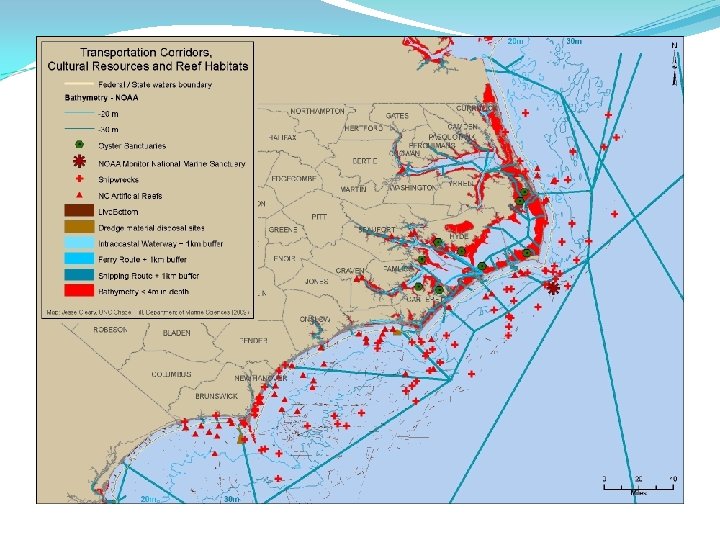
Navigation Corridors, Cultural Resources, Reef Habitats All marked navigation channels (ferries, shipping, intercoastal waterway), 1 km buffer on each side Shipwrecks, including Monitor National Marine Sanctuary Artificial reefs, live bottom and oyster sanctuaries Dumping sites
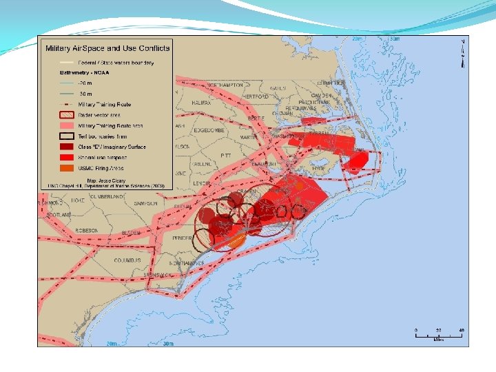
Military Conflicts Special use airspace Training routes Radar vector areas USMC firing ranges
Synergies – Positive Interactions A stone, scour apron surrounds the monopile base (12 -m radius with stones rising 2 -3 m above bottom) Excellent foundation for artificial oyster reef in Pamlico Sound (Albemarle Sound is too fresh for oysters) – restores oysters and their ecosystem services Excellent foundation for live-bottom reef in coastal ocean Restores reef fish, including aiding recovery of overfished snapper/grouper species complex Requires excluding fishermen to avoid overexploitation The apron and monopile may also serve as substrate for blue mussels north of Cape Hatteras. These would provide food for scoters and could be harvested. Wind farms may induce upwelling downstream In the sounds this could mitigate seasonal hypoxia and anoxia events In the coastal ocean this could enhance local primary production NOAA Thieler et al. 1995
Hurricane Risk Wind turbines engineered to withstand category 3 hurricane Hurricane risk in NC is high Landfalls and storm tracks of large hurricanes (Category 3, 4, or 5) show that the ocean well north of Cape Hatteras represents a region that receives some protection from the projecting cape to the south Hurricane (category 3 or greater) tracks since 1950 yellow – category 2 red – category 3 brown – category 4
Foundation Alternatives Monopile foundation with transition piece and scour protection. Flange height above sea level approximately 20 meters. Open gravity-based structure without ballast and at water depth of approximately 20 meters. The design shown includes an ice deflection cone.
Foundation Alternatives Installation vessels need at least 4 meters water depth
Geology S. Riggs (Geological Sciences, East Carolina) D. Ames (Geologic Sciences, East Carolina) Sound and ocean bottom geology Suitability for various types of wind turbine foundations
NASA ORBIMAGE 10 -3 -2000
ALBEMARLE-PAMLICO ESTUARINE COMPARTMENT RIGGS AND AMES, 2003
RIGGS AND AMES, 2009
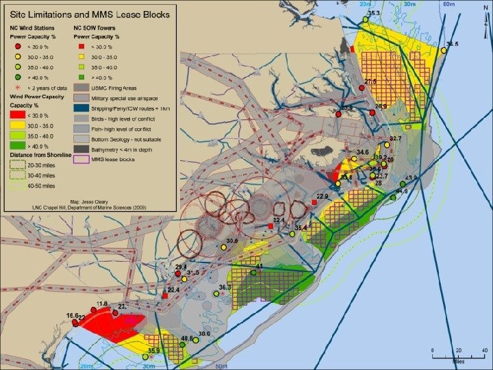
Synthesis Methodology Information from the individual groups was integrated into a geographic information system Emphasis was placed on identifying severe constraints likely to preclude any wind energy development Areas identified as no-build (e. g. too shallow, reserved for use by the military) and areas identified as having high ecological impact or low suitability for foundation construction were eliminated Each constraint equally weighted an equal degree of certainty as to their extents assumed Provides a conservative and introductory look at what areas remain viable for wind power development.
Synthesis Results Limited portion of State waters, restricted to the eastern half of Pamlico Sound, appears feasible for further study Large areas offshore are potentially well-suited for wind energy development. More than 2800 square miles of potential development area in waters less than 50 m deep and within 50 miles of the coastline Raleigh and Onslow Bay appear to have the most promising wind resource, with capacity factors exceeding 40% in water depths greater than 30 m Winds over the shelf north of Cape Hatteras do not appear as favorable as those to the south but it is important to note that there are no direct measurements of winds on the northern shelf in water depths less than 45 m 190 federal MMS lease blocks do not intersect with any constraint and have wind power capacity estimated in excess of 35%.
Strategic Direction Develop demonstration turbines no water-based wind turbine pilot projects ongoing in the US at this time Area in the Pamlico Sound identified as potentially suitable Support additional wind research More detailed wind resource analysis is needed US Navy has existing offshore platforms that could permit sophisticated wind observations to be collected inexpensively and quickly compared to other coastal areas which will need to first build offshore platforms
Strategic Direction Support additional utility transmission research North Carolina Transmission Planning Cooperative already exists Could be engaged at no cost to conduct such an evaluation for the central and southern portions of the coast to identify system upgrades NC investor-owned utilities could be asked to evaluate the costs for each to integrate large-scale wind energy into their generation dispatch.
Strategic Direction Establish state policy toward utility-scale wind farm development Other states have created incentives for developers to rapidly move towards installation of utility-scale wind farms North Carolina should define an approach to attract investment within the state. Leverage the expertise of the public universities
Questions