Coastal Landscapes Higher Geography Physical Environments Lithosphere Topic


- Slides: 79
Coastal Landscapes Higher Geography Physical Environments: Lithosphere
Topic Outline 1. Name and explain the erosion processes at work. 2. Explain the formation of the following erosional landforms with the aid of a diagram and named e. g’s: Cliffs, Wave-cut platforms, Caves, Arches, Stacks, Stumps, Geos. 3. Explain with the aid of a diagram, the process of longshore drift. 4. Explain the formation of the following features of deposition with the aid of a diagram and named e. g’s: Beaches (note there are various types), Spits, Tombolos, Sandbars, Sand dunes & Salt Marshes. 5. Identify coastal features on an O. S map.
Aims of the lesson • To learn about the types of wave affecting coastal landscapes. • To learn how to name and describe the processes of coastal erosion. • To learn how to describe the formation of headlands and bays with reference to a named example.
Swash & Backwash
Constructive Waves Flat and low in height. Its has a stronger swash than backwash. This means that it is responsible for depositing material on the coastline.
Destructive Waves Steep and high. The swash in this wave is weaker than the backwash. This means that material is removed from the beach leading to erosion.
Coastal Erosion Processes Hydraulic pressure Abrasion Corrosion Attrition results from large waves hurling beach /eroded material against a cliff. is when waves cause rocks and pebbles on the beach to bump into each other and wear down in size. is the sheer force of the waves especially when they trap and compress air in cracks and holes in a cliff. is when certain types of rock types in a cliff are actually slowly dissolved by the seawater.
Rate of Erosion Waves - Strength, frequency, height Weather frequency of storm conditions Geology of the coastline
Headlands & Bays Take a copy of the diagram below in your notes. Arrange the statements in order to describe the formation of headlands and bays.
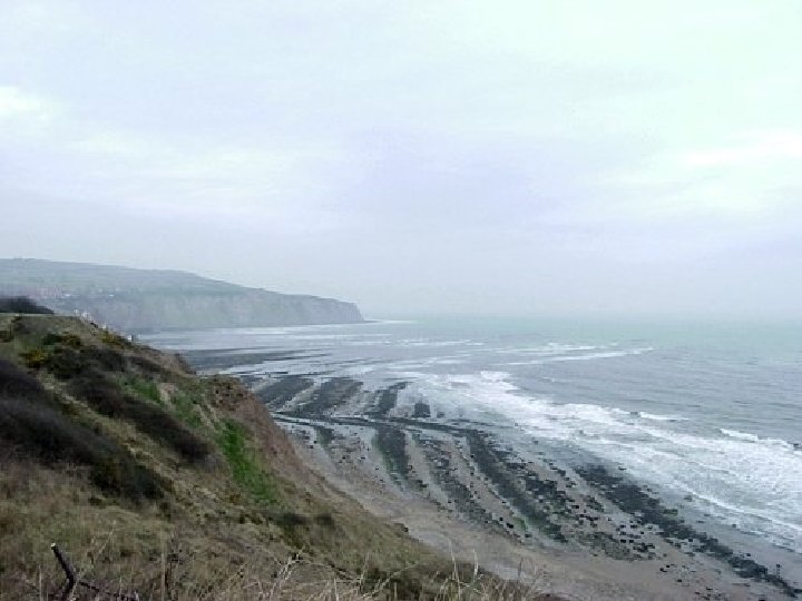
The softer rocks therefore erode backwards faster to form sheltered bays (which may have beaches), e. g. sandstone and clay and which meet the coast at right angles. Headlands and bays are formed due to differential erosion, whereas the harder rock areas jut out into the sea to form exposed headlands. An excellent example of this landform is Lulworth Cove on the Dorset coastline. Clay is a softer rock than the sandstone so is eroded more quickly. where rocks along the coastline are formed in alternating bands of different rock types
Lulworth Cove
Summary So far we have… • learnt about the types of wave affecting coastal landscapes. • learnt how to name and describe the processes of coastal erosion. • learnt how to describe the formation of headlands and bays with reference to a named example.
On the Wall! Each table has been given post-its. Get your answers stuck to the questions posted around the room First group wins!
On the Wall 1. Name the type of wave that leads to dominant erosion. 2. What is swash? 3. How long is the coastline of the UK in kilometres? Closest guess wins. 4. Name the 4 processes of coastal erosion. 5. Give a factor that will affect the rate of coastal erosion. 6. Draw a diagram of headlands & bays with a named example.
Headlands & Bays
Aims of the lesson • To learn how to describe the formation of a cliff and wave cut platform. • To learn named examples of these features.
Cliffs & Wave Cut Platforms This clip will give you an introduction to cliffs, wave cut platforms and other coastal erosion features. BBC Learning Zone - Cliffs & Wave Cut Platforms
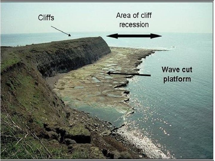
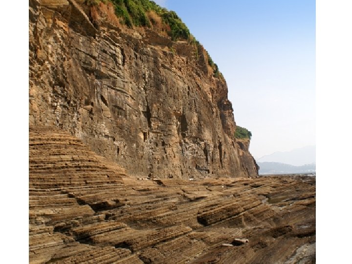
Cliffs & Wave Cut Platforms Cliffs form where high land reaches the sea. Weaknesses (joints and faultlines) in the rock are progressively undercut by wave erosion. This forms what is called a wave-cut notch. This notch is enlarged and eventually the overhanging rock collapses. As this processes is repeated, the cliff retreats, exposing a gently sloping rock surface called a wave cut platform.
Wave Cut Platform: South Glamorgan, Wales
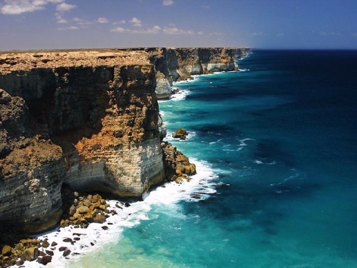
Hard Rock Cliffs Hard rocks are more resistant than soft ones, and will form steep cliff faces. Made up of rocks like basalt and granite. Named Example: Caithness
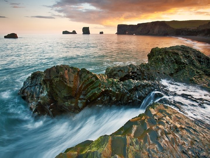
Soft Rock Cliffs These cliffs often erode rapidly. In these cliffs, sub-aerial processes can contribute more to erosion than marine processes, leading to mass movements such as sliding, slumping and falls. Named Example: Fairlight Cove, Hastings
Describe the formation of a cliff and a wave cut platform.
Summary So far we have… • Learnt the formation of a cliff and a wave cut platform with reference to a named example.
Match Up Diagram Current cliff location High tide point Cliff is undercut and collapses Wave-cut notch Wave-cut platform Original position of cliff
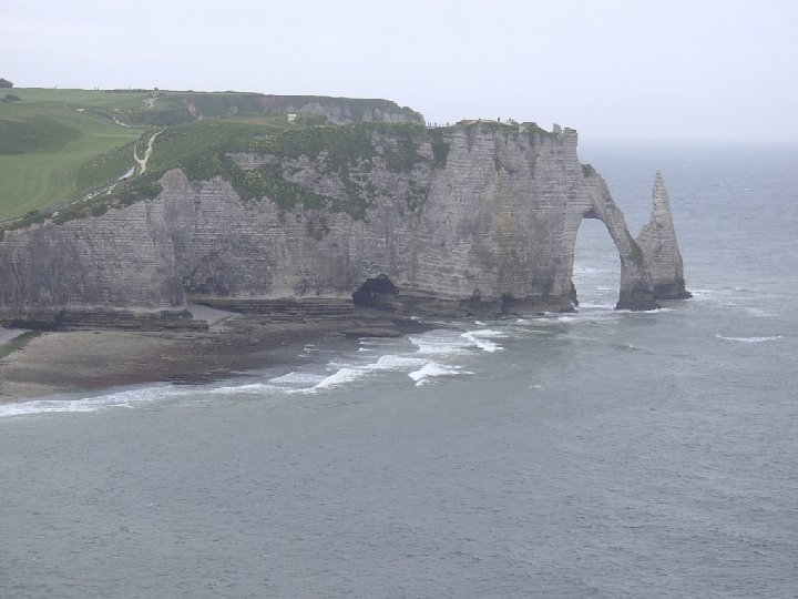
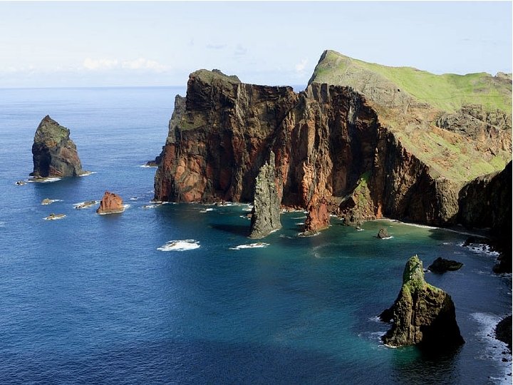
Aims of the lesson • To learn how to describe the formation of caves, arches and stacks. • To learn named examples of these features.
Green Arch of Wales
Durdle Door, Dorset
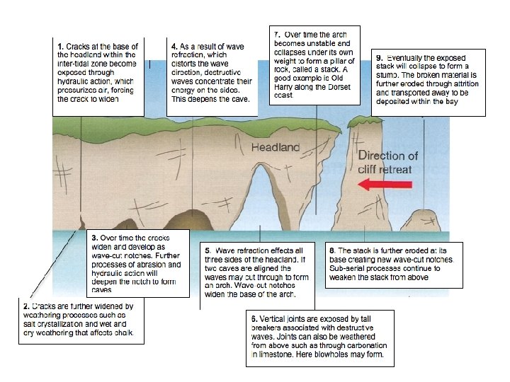
Caves, Arches, Stacks & Stumps
Caves, Arches, Stacks & Stumps Read p 123 & 124 of the Higher Textbook. Using the information contained on those pages, you are going to create a model that shows the formation of these landforms. Use the labels on the cards to annotate your model. Your model must include: • A crack • A cave • An arch • A stack • A stump • A blowhole
Large crack opened up by hydraulic action. The crack grows into a cave by hydraulic action and abrasion. Wave action creates wave cut notches at This leaves a tall rock the base of the arch, stack. widening it over time until it collapses. The cave becomes larger. The cave eventually breaks through the headland to form an arch. The stack is eroded by marine and sub aerial processes to form a stump. Continued erosion of a vertical joint in the headland may eventually form a blow-hole.
Large crack opened up by hydraulic action. The crack grows into a cave by hydraulic action and abrasion. Wave action creates wave cut notches at This leaves a tall rock the base of the arch, stack. widening it over time until it collapses. The cave becomes larger. The cave eventually breaks through the headland to form an arch. The stack is eroded by marine and sub aerial processes to form a stump. Continued erosion of a vertical joint in the headland may eventually form a blow-hole.
Fieldsketch On plain A 4 paper, create a simple fieldsketch of your model with all of the appropriate annotations. Use a ruler and pencil.
Homework With the aid of annotated diagrams, explain the formation of a stack. Tips: • Ensure you include fully annotated diagrams • You will need to refer to caves and arches also. • You must include the processes that form the features e. g. for stack, hydraulic action, attrition, corrasion.
Homework With the aid of annotated diagrams, explain the formation of a stack. Tips: • Ensure you include fully annotated diagrams • You will need to refer to caves and arches also. • You must include the processes that form the features e. g. for stack, hydraulic action, attrition, corrasion.
Summary So far we have… • learnt how to describe the formation of caves, arches and stacks. • learnt named examples of these features.
True or False 1. A constructive wave has a stronger swash than backwash. 2. Hydraulic action is the impact of rocks and other material on the cliff face. 3. Our named example of a wave cut platform is Durdle Door. 4. Hard rock cliffs are more vulnerable to weathering and often slump rather than collapsing into the sea in blocks. 5. The formation of headlands and bays is a result of a process called differential erosion. 6. A blowhole is a made up landform. 7. Our named example of an arch is in South Glamorgan, Wales.
Aims of the lesson • To be able to describe the process of longshore drift in coastal environments with reference to a diagram.
Longshore Drift Waves often approach a beach at an angle. The swash carries material up the beach at an angle and then the returning backwash drags much of the material back down. Over time, the material is moved along the shore in the direction of the prevailing wind. This processes of transportation is called longshore drift.
Direction of movement Backwash is always at right angles to the beach Swash Backwash This movement of sediment along the coastline is called longshore drift.
Longshore Drift Poster Activity Each of you is going to create a poster to demonstrate the process of coastal transportation. You must use all of the equipment provided. Use p 128 of the Higher Textbook to help you. Equipment • Set of cards & arrows • Scissors • Glue • A 4 coloured paper • Pen/pencils
Swash Arrows
Backwash Arrows
Transported Material
BEACH DIRECTION OF TRANSPORTED MATERIAL SEA 5 SH SWA SWA EV A WI ILING ND 3 6 BACKWASH PR 4 BACKWASH 1 BACKWASH SH 2 7
Review Question With the help of a labelled diagram, show the main features of longshore drift.
Summary So far we have… • described the process of longshore drift in coastal environments with reference to a diagram.
Starter Draw an annotated diagram to demonstrate a named process of coastal transportation. Use the whiteboards.
BEACH DIRECTION OF TRANSPORTED MATERIAL SEA 5 SH SWA SWA EV A WI ILING ND 3 6 BACKWASH PR 4 BACKWASH 1 BACKWASH SH 2 7
Aims of the lesson • To learn how to describe the formation of the following depositional landforms with reference to a diagram. – Beach – Spits – Tombolos – Sandbars & Lagoons • To learn named examples for these landforms.
Coastal Deposition Transportation of material stops once the environment becomes more sheltered. Currents weaken and they no longer have the energy to transport material. The water will also be much more shallow.
Deposition Landforms There are 4 main landforms that it is important we learn about: 1. 2. 3. 4. Beaches Sanspits Sandbars & Lagoons Tombolos Using the information on each of the stations you will: • Summarise formation into 4 bullet points • Draw a diagram • Give a named example 5 minutes at each station
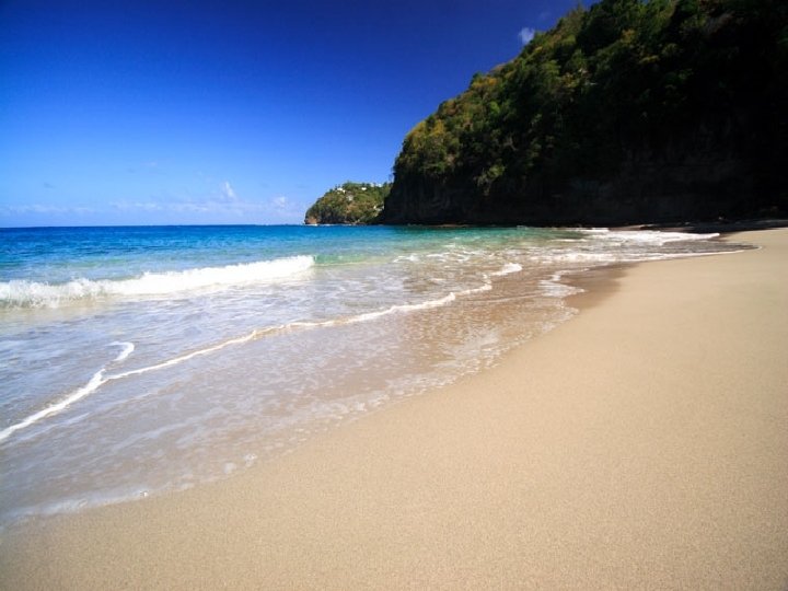
Beaches are the main features of coastal deposition. Beaches form in sheltered environments, such as bays. They are mainly produced by constructive waves with a strong swash and weak backwash. Named Example: Weymouth Beach
Types of Beach Shingle Sand Steep and narrow Wide and flat Large coarse material Smaller, finer material Produced by strong swash Produced by strong backwash
Sandspits Long, narrow accumulations of sand or shingle in the sea/ocean with one end attached to the land. The other end may be hooked due to currents
Longshore drift moves material along the coastline. There is a sudden change in the direction of the coastline that allows material to be deposited, building up and out. Over time, the spit grows and develops a hook if wind direction changes further out. This can also form if the spit crosses a river estuary. Waves cannot get past a spit, which creates a sheltered area where silt is deposited and mud flats or salt marshes form.
Sandbars & Lagoons Sandbars: Ridges of sediment formed parallel to the coast, these can join two points of headland. Lagoon: An area of still water cut of from the sea by coastal deposition. Example: Fleet Lagoon, Dorset.
What are bars and how are they created? A bar is formed where a spit continues to grow across a bay, creating a lagoon behind it. The lagoon, becomes an area of still water and a salt marsh forms in this low energy zone. Over time the lagoon will become infilled by deposition as either rivers flows in to it depositing material, or as waves break over the top of the Bar depositing coastal material
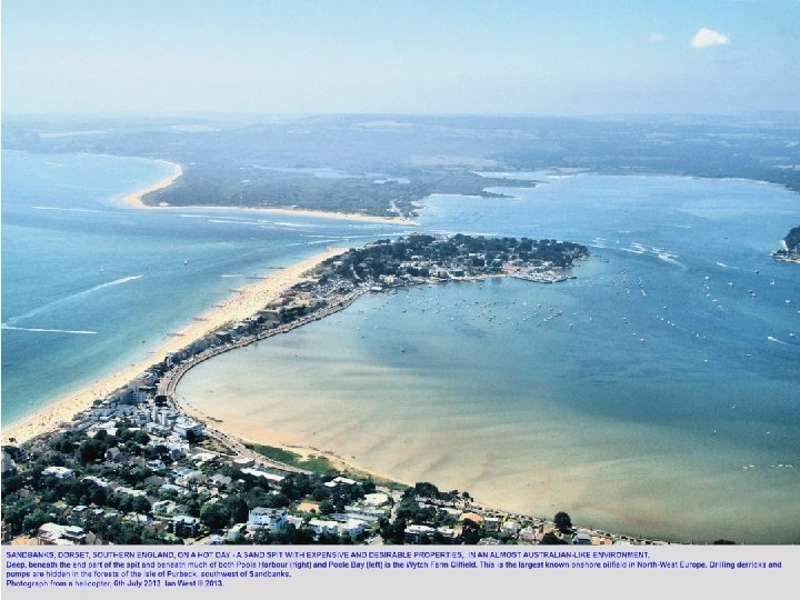
Tombolos Essentially this is a sand bar that joins the mainland to an island. An example of this is Chesil Beach, Dorset.
What are tombolo's and how are they created? Tombolo's are ridges of sand shingle (SPITS) which join the mainland to an island. They are created through the process of longshore drift.
Past Paper Question With the aid of annotated diagrams, explain the formation of a sandspit. (10 marks) Tips: • What does a sandspit look like? • What conditions are needed for coastal deposition to occur? • What process is taking place? • What may form behind the sandspit? • What other landforms can be created by its expansion? • Named example?
Sample Answer: Sandspit A sandspit is a long, narrow accumulation of sand or shingle extending out to sea or across a river estuary. It is a depositional coastal landform. Longshore drift is the process responsible for the transportation of material along coastlines. The prevailing winds drive the swash onshore at an angle which carries material up the beach. Once it has run out of energy the backwash retreats at a right angle to the beach carrying material with it. This process repeats itself and material is slowly transported along the coastline. Transportation of material stops once the environment becomes more sheltered. Currents weaken and they no longer have the energy to transport material. A sandspit will form if there is a sudden change in the direction of the coastline that allows material to be deposited, building up and out. Over time, the spit grows and develops a hook if wind direction changes further out to sea. This can also form if the spit crosses a river estuary as river currents will affect the build up of material. Waves cannot get past a sandspit, which creates a sheltered area where silt is deposited and mud flats or salt marshes form. Other landforms can be created by the expansion of a sandspit such as a sandbar or a tombolo. A sandbar is created if the spit grows across a bay or cove, cutting off some of the sea to form a lagoon. A tombolo forms if the sandspit connects an island with the mainland. An excellent example of this landform is Sandbanks in Dorset.
Erosional or Depositional Feature? Divide the landforms below into two columns, one for features created by erosion and one for features created by deposition. Arch Stack Sandbar Wave cut platform Tombolo Cliff Cave Sandspit Beach Lagoon
Aims of the lesson • To be able to identify erosional and depositional coastal landforms on an O. S. map.
Coastal Landforms on O. S. Maps As with the all of the other landscapes we have studied, you are expected to be able to identify coastal landforms on an O. S. map. This type of question can be worth as many as 12 marks! You will then be asked to explain the formation of one or more of the landforms you have identified. Digimap for schools - Aberdeen
O. S. Map Sections You have each been given a pair of O. S. Maps. One shows a coastline of erosion, the other shows a coastline of deposition. In groups, try to identify as many features as you can. In pencil annotate the O. S. maps to show coastal landforms.
Coastline of Erosion
Coastline of Deposition
2008 Past Paper Question Study O. S. Map of Swanage and Reference diagram Q 1. Describe the map evidence that shows: • Area A and B areas of coastal erosion. • Area C is an area of coastal deposition. 12 marks
Summary So far we have… • identified erosional and depositional coastal landforms on an O. S. map.