Coastal Charlotte Harbor Monitoring Network by Catherine A

Coastal Charlotte Harbor Monitoring Network by Catherine A. Corbett Charlotte Harbor National Estuary Program

National Estuary Programs

What is the National Estuary Program? n n n EPA supported program 28 in the United States 4 in Florida: Tampa Bay, Sarasota Bay, Indian River Lagoon and Charlotte Harbor A unique planning process based on collaborative decision-making and consensus A process that encourages stakeholders to participate in the development and implementation of a Comprehensive Conservation and Management Plan (CCMP)

Charlotte Harbor NEP Partners n n n U. S. Environmental n Protection Agency U. S. Fish and Wildlife n Service NOAA-National Marine n Fisheries Service U. S. Army Corps of Engineers U. S. D. A. -Natural Resources n Conservation Service Southwest and South Florida Water Management Districtsn Florida Department of Environmental Protection Florida Fish and Wildlife Conservation Commission Sarasota, Manatee, Charlotte, Lee, Polk, Hardee and De. Soto Counties Southwest and Central Florida Regional Planning Councils and Others

Produced by the Southwest Florida Water Management District

Charlotte Harbor Watershed Polk Eight distinct subbasins, from Coastal Venice to Estero Bay § Manatee Hardee Sarasota De. Soto Peace, Myakka & tidal Caloosahatchee rivers § Charlotte Covers all or part of 7 counties § Lee FMRI, 2001

Florida Department of Environmental Protection 2 Districts in the watershed

2 Water Management Districts in the Watershed

Current Surface Water Quality Monitoring Sites City of Punta Gorda - 9 fixed sites sampled monthly City of Cape Coral - 33 fixed sites sampled on a monthly basis

Current Surface Water Quality Monitoring Sites Polk County 27 -33 fixed stations per year in Peace River basin quarterly Lee County 14 sites monthly in Pine Island Sound and Matlacha; 14 sites monthly in Estero Bay

Current Surface Water Quality Monitoring Sites Manatee County 2 fixed sites in upper Myakka River on monthly basis; 9 biweekly sites for TMDLs Sarasota County 40 sites per month in County, another 40 the next month etc; total of 480 sites per year

Current Surface Water Quality Monitoring Sites SWFWMD 11 & 5 fixed monthly stations in Peace & Myakka rivers respectively; 16 sites in Flatford Swamp SFWMD 4 fixed stations monthly in tidal Caloosahatchee River

Current Surface Water Quality Monitoring Sites PR/MRWSA § 3 U. S. G. S. flow gages at 15 minute intervals; 2 collect conductivity § 4 “moving” salinitybased isohaline stations monthly § 16 fixed monthly

Current Surface Water Quality Monitoring Sites CHEVWQMN-DEPAquatic Preserves Volunteers monitor about 44 sites from Lemon to Estero Bays, Charlotte Harbor and tidal rivers

NEP Water Quality Goals SWFWMD Lake Hancock, Upper Peace River § Identify those waterbodies that do not meet their designated water quality standards and develop a plan during the year 2000 to meet those standards. § Meet or exceed designated water quality standards throughout basins of the Charlotte Harbor NEP study area by the year 2015 with possible exceptions for natural and/or site-specific conditions.

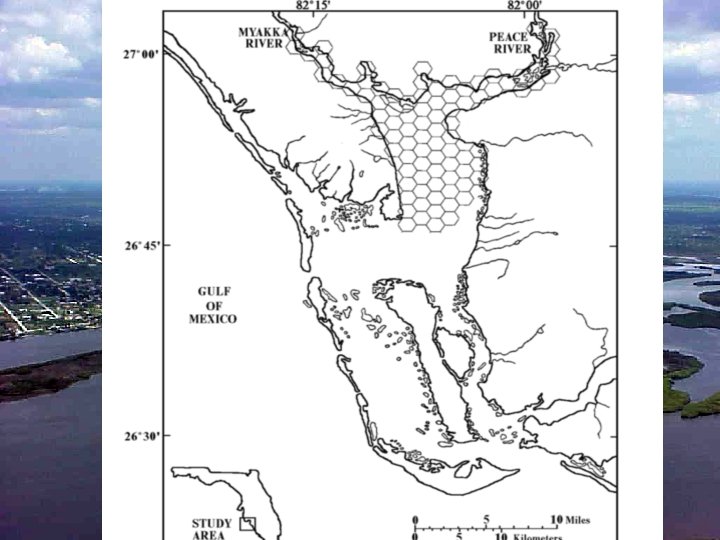
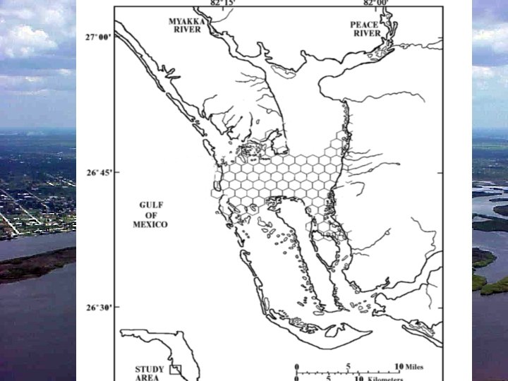
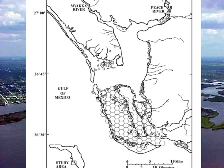
Charlotte Harbor NEP Long Term Monitoring Strategy n n n Fixed stations in fresh water Stratified, random stations for all tidal waters Stratified according to estuarine basin = 6 strata Gasparilla-Venice/Lemon Bay Upper Charlotte Harbor Lower Charlotte Harbor Pine Island Sound/San Carlos Bay Tidal Caloosahatchee River and Estero Bay 30 hexagons overlaid on each stratum; 1 site randomly chosen within each hexagon; equal opportunity to sample all sites within stratum 30 sites per season; 2 seasons per year = 60 sites/yr

Coastal Charlotte Harbor Monitoring Network Katie Fuhr & Judy Ott of FDEP

Coastal Charlotte Harbor Monitoring Network n n SWFWMD, FWC-FMRI, DEP-Aquatic Preserves and Charlotte County—started in April 2001 Monitor 6 strata monthly: Tidal Peace River • Tidal Myakka River • West wall of Charlotte Harbor • East wall of Charlotte Harbor Cape Haze/Lower Charlotte Harbor proper • Lower Lemon Bay • • n 5 sites per stratum, randomly chosen—re-randomized each month; equals 30 sites per season and 60 sites per year

Coastal Charlotte Harbor Monitoring Network n Expansion of this program into 6 more strata: § § n n Bokeelia area of Charlotte Harbor, § Pine Island Sound, § Matlacha Pass, § San Carlos Bay, the tidal Caloosahatchee River and § Estero Bay SFWMD, Lee County, DEP-Aquatic Preserves, and the Cities of Cape Coral and Sanibel Started April/May 2002

• 1 st choose grid within stratum • then choose site within grid Monitoring Network’s Square Grid System

• 12 strata • 5 sites/ month randomly chosen • 30 sites per season

Program Design n Objective, unbiased results that answer: t. Is the water quality changing through time for a specific water body? t. Did water quality change as a result of implementing some management practice? t. Did water quality change by some specific target level? n Data will approach normal distribution with N 30; therefore can use parametric statistics to determine means between strata, between seasons and between years

Program Benefits Comprehensive, area-wide program to monitor water quality n Cooperative, inter-agency effort n Same sampling protocols used for entire network; help ensure data comparability n Low number of labs will also help ensure data comparability n Parametric statistical data analysis to determine means between strata, between seasons and between years n

Problems Encountered n Entering data into STORET u hired contractor to develop protocols to allow Members to upload their data independently n Lab Analysis Comparability u developed list of laboratory data quality objectives n Field Sampling Comparability u developed Standard Operating Procedures manual and annual field audit

Acknowledgements n n n David Tomasko, SWFWMDSWIM Rebecca Hensley & Philip Stevens, FWC-FMRI Judy Ott & Elizabeth Staugler, DEP-CHASBP Charles Walter & Michael Tisch, Charlotte County Keith Kibbey, Lee County Connie Jarvis, City of Cape Coral n n n James Evans, City of Sanibel Peter Doering & Dan Crean, SFWMD Dan Quick & Joanne Vernon, Charlotte County Gerold Morrison & Al Cheatham, Charlotte Harbor Environmental Center others

Contact: Catherine Corbett Charlotte Harbor National Estuary Program 239/995 -1777 email: ccorbett@swfrpc. org Myakka River Croc By Re. Anna Montwheler, FMRI
- Slides: 29