Clouds Formation and Types Pages 506 511 Clouds

 suspended")


 – fine weather • Cirrocumulus (high")


- Slides: 55
Clouds Formation and Types Pages 506 -511
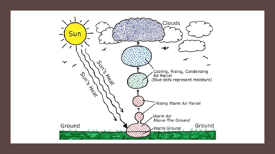
Clouds • A cloud is a collection small water droplets or (ice crystals) suspended in the air. • Forms when the air rises and cools, and condenses. • Above 0°C water droplets • Below 0°C ice crystals • Need a surface (nuclei) on which to condense (dust, pollen, spores, pollution).
Cloud in a Bottle At home activity: Materials: Empty plastic water bottle, match, water. Fill a plastic water bottle ¾ up with water. Strike a match, let it burn a bit then drop it into the water. Immediately seal the bottle with the cap. Alternately Squeeze and release the bottle. Do you see the cloud appear and disappear?
Cloud in a bottle demo • https: //www. youtube. com/watch? v=G 70 y 90 BVes 4
Cloud demo: What happened? • The match added smoke particles which provides the water particles with something to condense on (condensation nuclei). • Squeezing the bottle increases pressure. • Letting go reduces pressure, allowing water to cool and condense.
Why does air cool when it rises? • When air rises it expands because it is moving from higher to lower pressure. (Air pressure decreases with altitude). • Air cools when it expands because the frequency collisions decreases as air expands (more space between the particles) • Air coming out of a tire or aerosol can is cool.
Methods of Cloud Formation • Different clouds form in different ways depending on: • what causes the warm, moist air to rise into the upper troposphere. • 3 Main cloud formation methods
1. Convection: Warm, moist air rising.
2. Lifting: Warm, moist air moving up the side of a mountain. Along its journey, the air is lifted higher into the troposphere where the pressure is lower. The water vapor in the air is allowed to cool and form clouds. This is why we often see clouds over mountains.
3. Frontal Activity Warm, moist air being forced to rise by a cooler air mass. The warm, moist air rises into the troposphere. The lower pressure of the upper troposphere causes the water vapor in the warm air to cool and form a cloud.
Frontal Activity
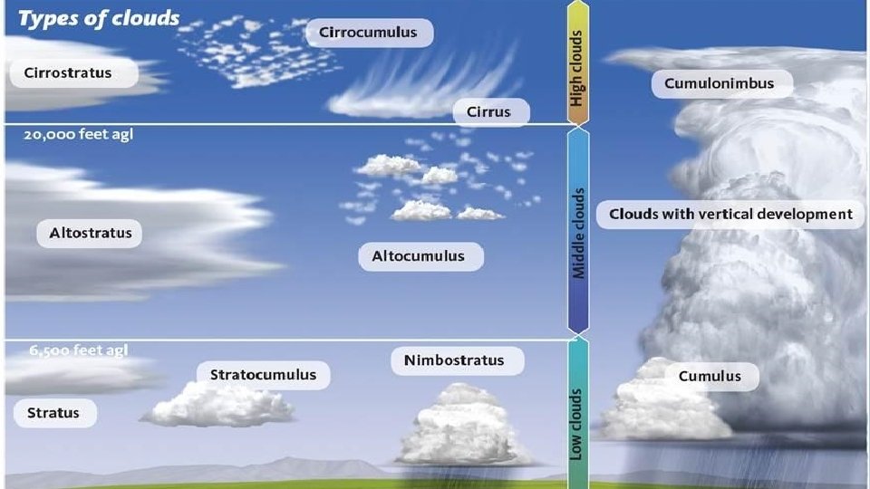
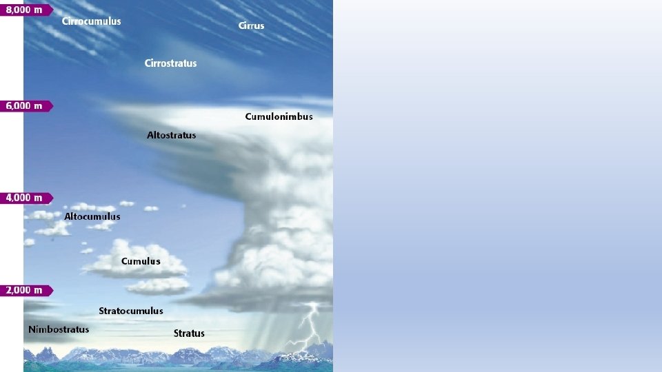
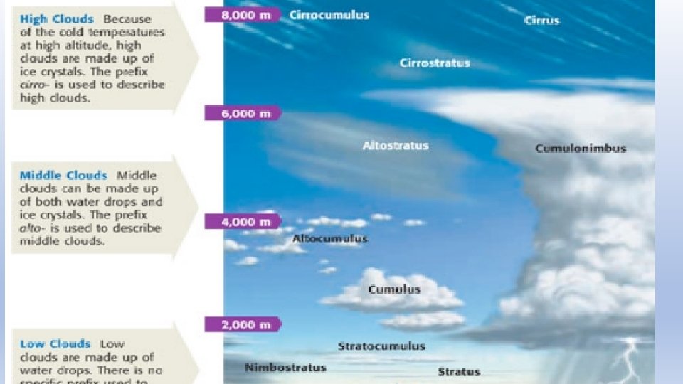
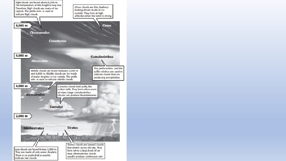
Types of Clouds • Clouds are classified by shape, altitude, and their precipitation. • The three main cloud shapes are: • stratus clouds, cumulus clouds, and cirrus clouds. • The three altitude groups are: • low clouds, middle clouds, and high clouds.
Cumulus - Heaped • Puffy, white clouds that tend to have flat bottoms • Formed when warm air rises • Indicates fair weather • Piled, lumpy, billowy
Stratus - Layered • Form in layers • Cover large area, often blocks out sun or moon • Formed by gentle lifting of a large mass of air • Sheets, blanket
FOG – stratus cloud that comes in contact with the ground
Cirrostratus Blanket the sky and are usually translucent
Cirrus – Curl of hair • Thin, feathery, white clouds • Highest altitudes • Formed when the wind is strong • Indicates approaching bad weather • Wispy looking, horse tails • Form where air is cold, so made of ice crystals
Nimbus – Rain Cloud • When nimbo or nimbus is part of the cloud’s name it means precipitation might fall • There are two types: • cumulonimbus (cumulus clouds) • nimbostratus (stratus clouds).
Cumulonimbus A cumulus cloud that indicates thunderstorms and heavy rain.
Nimbostratus A stratus cloud that produces light to heavy continuous rain, sleet, or snow
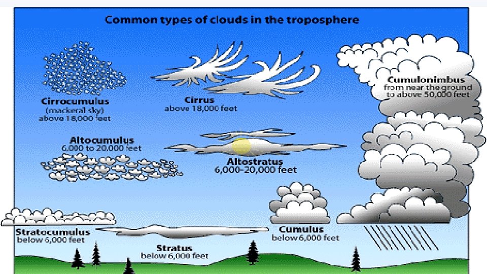
Clouds are also classified by altitude Low Clouds = Stratus: below 2000 m Middle Clouds = Alto: 2000 m to 6000 m High Clouds = Cirrus: start at 6000 m and up
Cloud Cover indicated by weather stations • The symbol highlighted in yellow indicates the amount of cloud cover observed at the time the observation is taken. In this case, broken clouds were reported.
Cloud Cover Chart
Special Clouds
Special Clouds: Mammatus Clouds
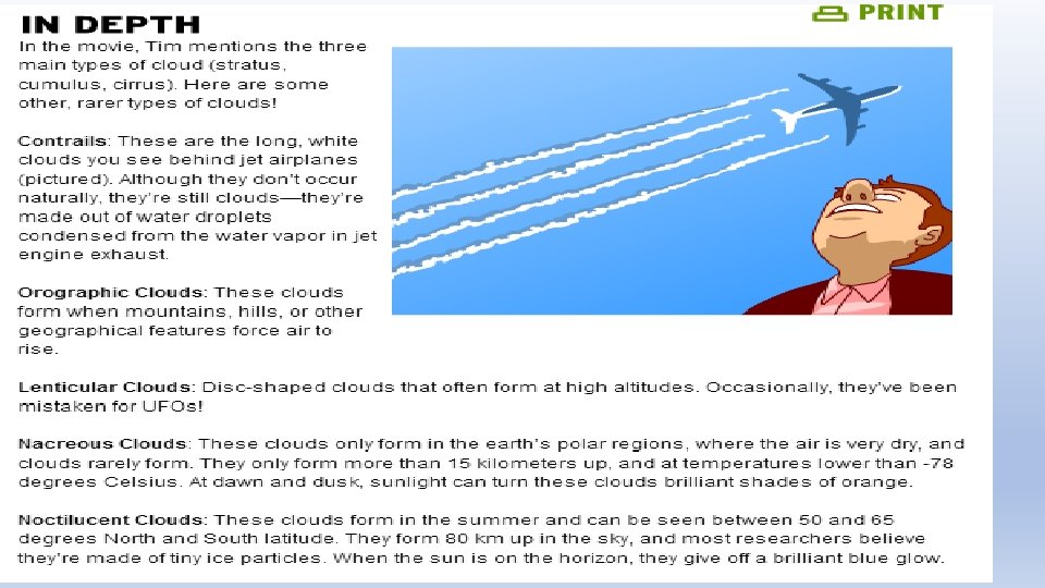
Contrails • short for "condensation trails“ • Line-shaped clouds produced by aircraft engine exhaust • composed primarily of water, in the form of ice crystals.
Orographic clouds Produced by the flow of air interacting Orographic clouds – produced by the flow of air ineracting with mountainous terrain. CAP cloud
Lenticular cloud Lens-shaped clouds that can result from strong wind flow over rugged terrain
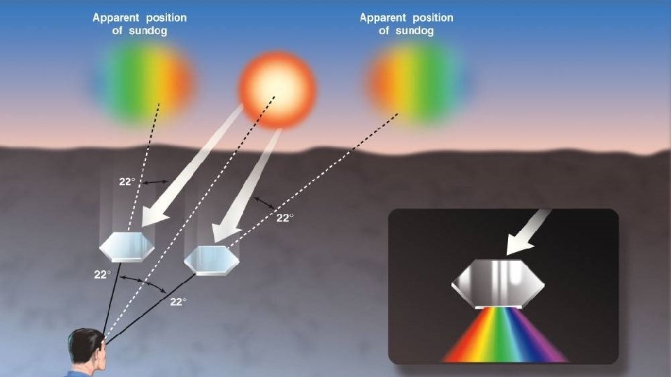
Sun Dog
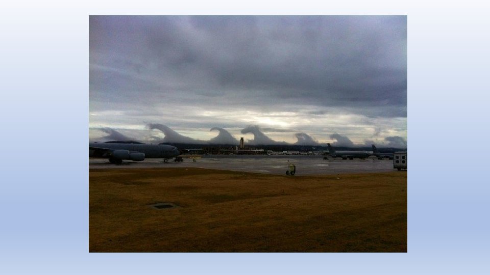
These clouds are called Undulatus Asperatus. They are very rare
http: //www. brainpop. com/science/weather/clouds/
Practice • Read p 506 -511 • Cloud WS • Answer #10, 11, 12 a, 13 a, 15 on p 511
Activity • Make a rain gauge
Stratocumulus - typically form after it rains, but before the sky clears. Has characteristics of both stratus and cumulus clouds.
Medium Altitude clouds 2000 -6000 m • Alltocumulus • Appear “puffier” than high level cirrocumuls because we’re closer to them • They can contain ice crystals and/or water droplets and may occuasionlly be associate with some light ppt.
High Altitude Clouds Cirruocumulus
LOW altitude clouds – below 2000 m • Low clouds are most often composed of water droplets, but can have ice crystals in colder climates • Cumulus
Stratocumulus
Stratus People often refer to a stratus cloud filled sky as “overcast”
Multilayer Clouds - Nimbostratus • Gray and rainy day is usually filled with Nimbstratus • Associated with larges areas of continuous precipitation
10. CUMULONIMBUS Can extend above 60, 000 feet They usually have large anvil-shaped tops These are the clouds that can produce lightning, thunder, heavy rains, hail, strong winds, and tornadoes.
Cloud Type by Rain • Finally, we can classify them based on the presence of rain • Nimbus: any cloud that rains Cumulonimbus: taller, towering versions of cumulus clouds. Their height can be from two to five miles. These clouds often form thunderstorms. Nimbostratus: low, flat clouds that are often associated with steady precipitation and occur in thick, continuous layers and are often dark gray in color.
What the Clouds Tell Us • Cirrus (high) – fine weather • Cirrocumulus (high puffy) – unsettled weather • Cirrostratus (high horizontal) – approaching rain or snow • Altostratus – rain or snow likely if cloud thickens • Nimbostratus – rain or snow! • Stratus – maybe light rain or drizzle • Cumulus – sunny days
What the Clouds Tell Us • Dark clouds – storm clouds, high water droplet content and density, so they block light • Green tinge – thunderstorm clouds whose ice particles scatter light • Yellow tinge – contains smoke (forest fires)
Determining Cloud Level To determine cumulus cloud level hold your hand out at arm’s length and compare the size of the cloud “part” to the following: • Low-level cumulus clouds are about the same size, or larger than, your fist. • Mid-level cumulus clouds are farther away and the individual cloud pieces are about the size of your thumb. • High-level cumulus clouds are smaller still, with individual cloud pieces about the size of the nail on your little finger.