Clouds and Precipitation Lifting condensation and cloud development
 Types of")


 Clouds • In a supersaturated environment, activated cloud")


")


 • Ice binds water molecules")


- Slides: 32
Clouds and Precipitation Lifting, condensation, and cloud development Deep convective clouds (thunderstorms) Types of clouds and how they form Collision and coalescence of raindrops Crucial roles of ice in most precipitation
Cloud Development Clouds form as air rises, expands and cools • Most clouds form by – Surface heating and free convection – Lifting of air over topography – Widespread air lifting due to surface convergence – Lifting along weather fronts
Fair-Weather Cumulus Cloud Development • Air rises due to surface heating • RH rises as rising parcel cools • Cloud forms at RH ~ 100% • Rising is strongly suppressed at base of subsidence inversion produced from sinking motion aloft • Sinking air is found between cloud elements
Fair weather cumulus cloud development schematic
What conditions support taller cumulus development ? • A less stable atmospheric (steeper lapse rate) profile permits greater vertical motion • Lots of low-level moisture permits latent heating to warm parcel, accelerating it upward
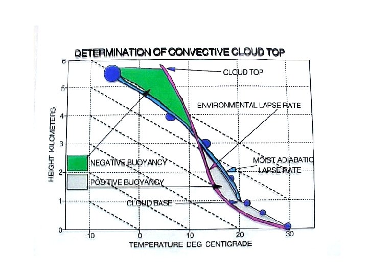
Determining convective cloud top • Cloud top is defined by the upper limit to air parcel rise • The area between the dry/moist adiabatic lapse rate, showing an air parcel’s temperature during ascent, and the environmental lapse rate, can be divided into two parts – A positive acceleration part where the parcel is warmer than the environment – A negative acceleration part where the parcel is colder than the environment • The approximate cloud top height will be that altitude where the negative acceleration area is equal to the positive acceleration area
Orographic clouds • Forced lifting along a topographic barrier causes air parcel expansion and cooling • Clouds and precipitation often develop on upwind side of obstacle • Air dries further during descent on downwind side
Lenticular Clouds • Stable air flowing over a mountain range often forms a series of waves – Like water waves formed downstream of a submerged boulder • Air cools during rising portion of wave and warms during descent • Clouds form near crests of waves • A large swirling eddy (rotor) sometimes forms beneath the lee wave cloud (dangerous for aircraft)
Fair-Weather Cumulus Clouds
Cumulus to Cumulonimbus Transition
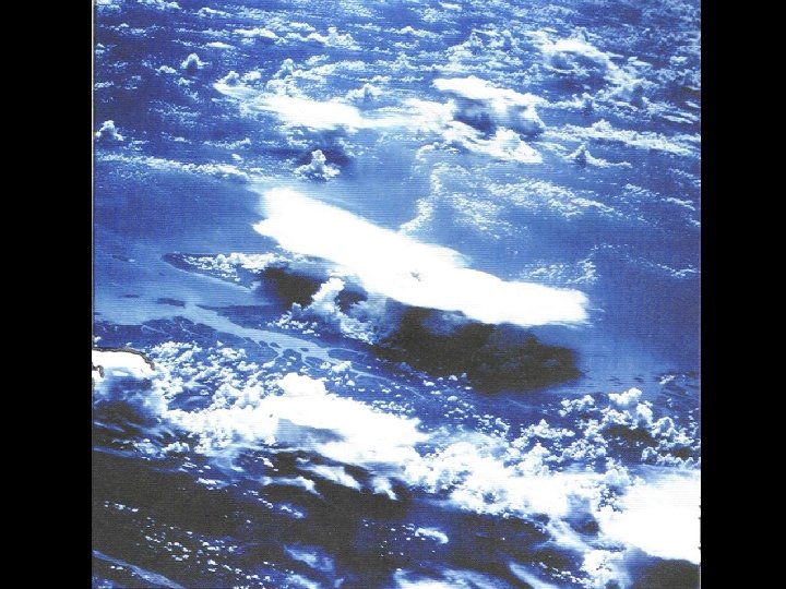
Convective clouds seen from space Anvil at cloud-top shows level of extreme stability associated with ozone heating in the stratosphere
Cloud Classification Clouds are categorized by their height, appearance and vertical development – High Clouds - generally above 16, 000 ft at middle latitudes • Cirrus, Cirrostratus, Cirrocumulus – Middle Clouds – 7, 000 -23, 000 feet • Altostratus, Altocumulus – Low Clouds - below 7, 000 ft • Stratus, stratocumulus, nimbostratus – Vertically “developed” clouds (via convection) • Cumulus, Cumulonimbus
Cloud Type Summary
Cirrus
Stratiform cloud layers
Precipitation Formation How many 20 µm cloud drops does it take to make a single 2000 µm rain drop? V = 4/3 pr 3 Vraindrop/Vcloud-drop = (rraindrop/rcloud-drop)3 = (100)3 ~ 1 million! How does precipitation form from tiny cloud drops? 1. Warm rain processes (collision and coalescence) 2. The Bergeron (ice crystal) process 3. “Ice multiplication”
Rain Formation in Warm (not frozen) Clouds • In a supersaturated environment, activated cloud drops grow by water vapor condensation – It takes many, many hours for the cloud drop to approach rain drop size • Collisions between cloud drops can produce large rain drops much faster through coalescence – Collisions occur due to different settling rates of large and small drops – Not all collisions result in coalescence • Warm rain formation favored by: – Wide range of drop sizes (big drops overtake small ones) – Thick cloud (more chances for collisions) – Fast updrafts
Rain formation in warm clouds - II • Capture of a cloud/rain drop in a cloud updraft can give it more time to grow – The drop falls at a fixed speed relative to the air, not the ground – Large drops fall faster
Rain Drop Size and Shape • Drizzle drops – 100’s of µm • Rain drops – a few millimeters – Rain drops larger than 5 mm tend to break up • When colliding with other drops • From internal oscillations • Rain drops have shapes ranging from spherical (small drops) to flattened spheroids (large drops) – In large drops surface tension is no longer strong enough to overcome flattening of falling drop due to pressure effects
Collision, Coalescence, & Breakup (High-resolution hydrodynamic simulation)
Ice Crystal Processes in Cold Clouds • Outside deepest tropics most precipitation is formed via ice crystal growth • Supercooled cloud drops and ice crystals coexist for – 40º < T < 0º C – Lack of freezing nuclei to “glaciate” drops • Ice crystals can grow by – Water vapor deposition – Capture of cloud drops (accretion/riming) – Aggregation
Ice Crystals and Ice Nuclei • Ice crystal shapes depend on the environmental temperature and vapor pressure • Ice crystal formation usually involves ice nuclei • Ice nuclei – Are much less common than cloud condensation nuclei – Include some clay mineral particles, bacteria and plant leaf detritus – Initiate the freezing of water droplets at temperatures between 0ºC and -40ºC – Artificial ice nuclei, used for cloud seeding, include dry ice and silver iodide Thin Plates Hollow Columns Needles Dendrites Sector Plates Hollow Columns
Recall: Water Vapor Saturation vs T • Saturation vapor pressure over ice is less than that over liquid water at a given temperature • In mixed-phase clouds, liquid water can evaporate even as vapor is deposited onto ice
Ice Crystal Growth by Direct Vapor Deposition (Bergeron process) • Ice binds water molecules more tightly than liquid water • This leads to evaporation of water from supercooled cloud drops and deposition onto ice crystals • Ice crystals grow at the expense of liquid droplets
Ice Crystal Growth by Accretion • Large ice crystals fall faster than smaller liquid droplets • Crystal/drop collisions allow ice crystals to capture cloud drops – The supercooled drops freeze upon contact with the ice crystal – This process is known as accretion or riming • Extreme crystal riming leads to the formation of – Graupel – Hail
Ice Crystal Growth by Aggregation • Crystal/crystal collisions can lead to formation of crystal aggregates – Crystals most likely to stick when a liquid water layer resides on the crystal surface • Watch for large aggregates/snowflakes when temperatures are close to 0º C
Precipitation in cold clouds • Low liquid water content promotes diffusion/deposition growth of large crystals • High liquid water content promotes riming and formation of graupel/hail • If the sub-cloud layer is warm, snow or graupel may melt into raindrops before reaching the surface (typical process for summer rain in Colorado)
Precipitation types • Rain that evaporates before reaching the surface is termed virga – Common in Colorado’s dry climate • Precipitation reaching the surface can take on different forms depending on the vertical temperature profile
Freezing rain and riming • Freezing rain coats surfaces with large quantities of ice – Trees break, power lines fall, roads are treacherous • Supercooled cloud drops collected by trees (or other structures) are known as rime • Collection of supercooled rain and cloud drops poses a hazard in the form of aircraft icing Mt. Washington, NH
Hail • Hail can form in clouds with – High supercooled liquid water content – Very strong updrafts • Hailstones associated with deep and intense cumulonimbus – Typically make 2 -3 trips up through cloud • Opaque and clear ice layers form – Opaque represents rapid freezing of accreted drops – Clear represents slower freezing during higher water accretion rates – Layering tells about hailstone history The largest hailstone ever recovered in the United States, a seven -inch (17. 8 centimeter) wide chunk of ice almost as large as a soccer ball. It was found in Aurora, Nebraska on June 22, 2003. The hailstone lost nearly half of its mass upon landing on the rain gutter of a house