
Cloud reporting practices and experiences at KNMI Wiel







- Slides: 26
Cloud reporting practices and experiences at KNMI Wiel Wauben R&D Observations & Data Technology
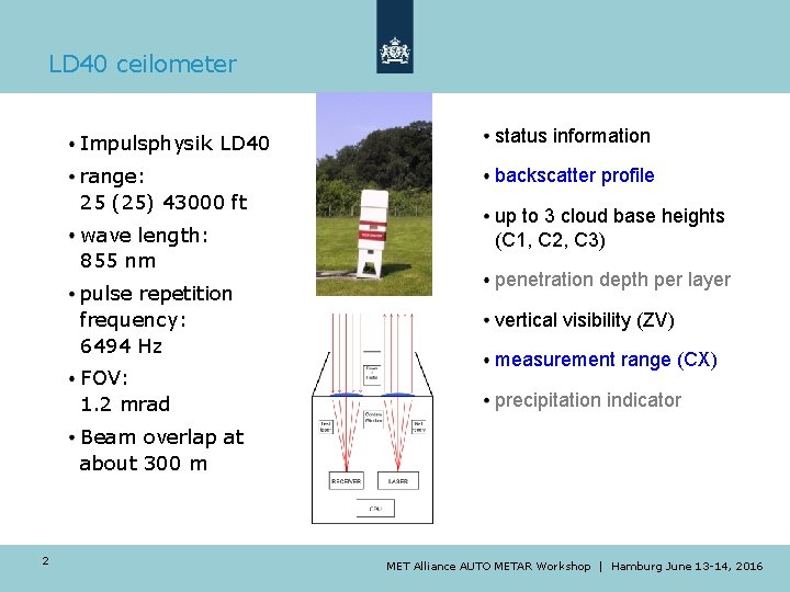
LD 40 ceilometer Impulsphysik LD 40 status information range: 25 (25) 43000 ft backscatter profile wave length: 855 nm pulse repetition frequency: 6494 Hz FOV: 1. 2 mrad up to 3 cloud base heights (C 1, C 2, C 3) penetration depth per layer vertical visibility (ZV) measurement range (CX) precipitation indicator Beam overlap at about 300 m 2 MET Alliance AUTO METAR Workshop | Hamburg June 13 -14, 2016
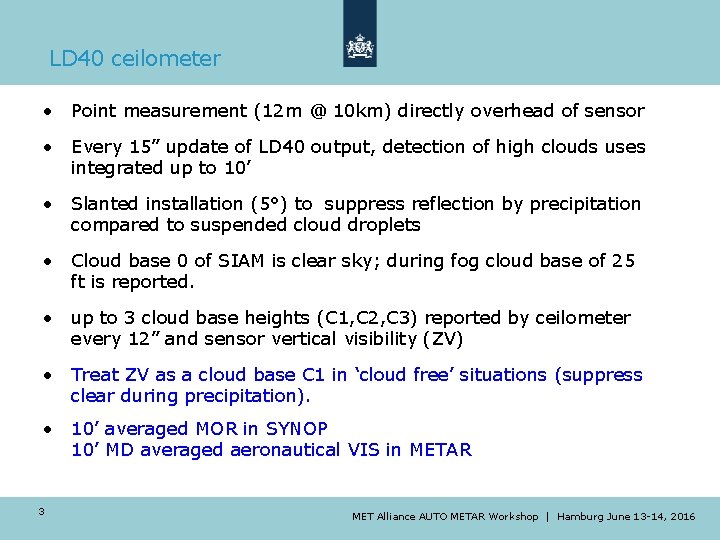
LD 40 ceilometer • Point measurement (12 m @ 10 km) directly overhead of sensor • Every 15” update of LD 40 output, detection of high clouds uses integrated up to 10’ • Slanted installation (5°) to suppress reflection by precipitation compared to suspended cloud droplets • Cloud base 0 of SIAM is clear sky; during fog cloud base of 25 ft is reported. • up to 3 cloud base heights (C 1, C 2, C 3) reported by ceilometer every 12” and sensor vertical visibility (ZV) • Treat ZV as a cloud base C 1 in ‘cloud free’ situations (suppress clear during precipitation). • 10’ averaged MOR in SYNOP 10’ MD averaged aeronautical VIS in METAR 3 MET Alliance AUTO METAR Workshop | Hamburg June 13 -14, 2016
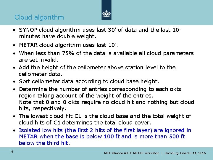
Cloud algorithm • SYNOP cloud algorithm uses last 30’ of data and the last 10 minutes have double weight. • METAR cloud algorithm uses last 10’. • When less than 75% of the data is available all cloud parameters are set invalid. • Add the height of the ceilometer above station level to the ceilometer data. • Sort ceilometer data according to cloud base height. • Determine the number of entries corresponding to each okta region taking account of the weight of the entries. Note that 0 and 8 okta require no cloud hit and nothing but cloud hits, respectively. • The lowest cloud hit C 1 is the cloud base and the total weight of cloud hits of C 1 determines the total cloud cover. • Isolated low hits (the first 2 hits of the first layer) are ignored in METAR when the base is below 100 ft and is more than 500 ft below the third hit. 4 MET Alliance AUTO METAR Workshop | Hamburg June 13 -14, 2016
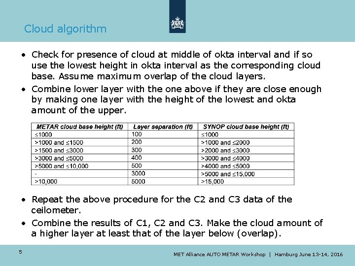
Cloud algorithm • Check for presence of cloud at middle of okta interval and if so use the lowest height in okta interval as the corresponding cloud base. Assume maximum overlap of the cloud layers. • Combine lower layer with the one above if they are close enough by making one layer with the height of the lowest and okta amount of the upper. • Repeat the above procedure for the C 2 and C 3 data of the ceilometer. • Combine the results of C 1, C 2 and C 3. Make the cloud amount of a higher layer at least that of the layer below (overlap). 5 MET Alliance AUTO METAR Workshop | Hamburg June 13 -14, 2016
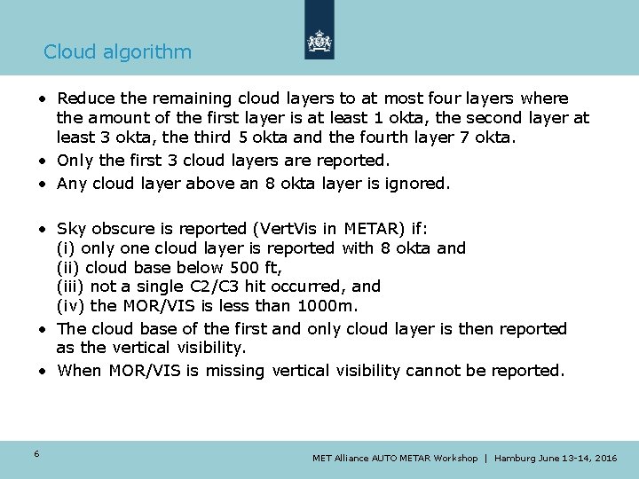
Cloud algorithm • Reduce the remaining cloud layers to at most four layers where the amount of the first layer is at least 1 okta, the second layer at least 3 okta, the third 5 okta and the fourth layer 7 okta. • Only the first 3 cloud layers are reported. • Any cloud layer above an 8 okta layer is ignored. • Sky obscure is reported (Vert. Vis in METAR) if: (i) only one cloud layer is reported with 8 okta and (ii) cloud base below 500 ft, (iii) not a single C 2/C 3 hit occurred, and (iv) the MOR/VIS is less than 1000 m. • The cloud base of the first and only cloud layer is then reported as the vertical visibility. • When MOR/VIS is missing vertical visibility cannot be reported. 6 MET Alliance AUTO METAR Workshop | Hamburg June 13 -14, 2016
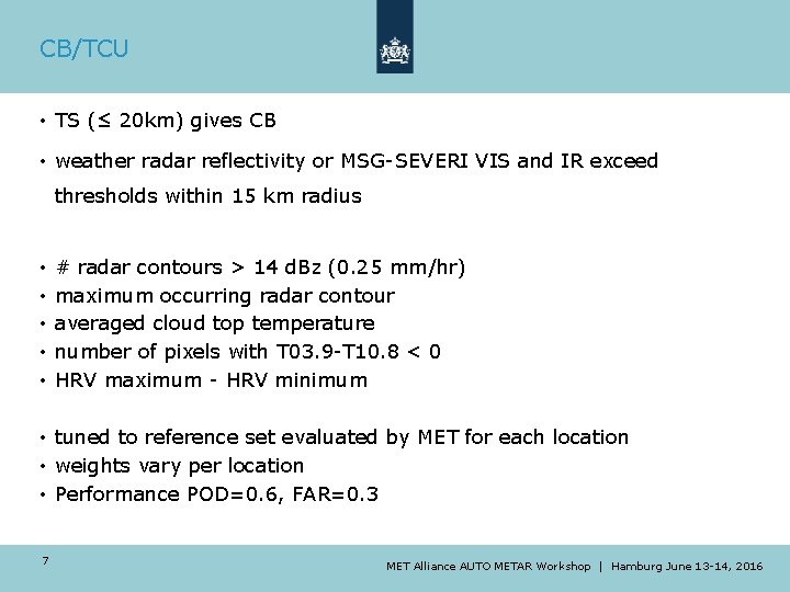
CB/TCU • TS (≤ 20 km) gives CB • weather radar reflectivity or MSG-SEVERI VIS and IR exceed thresholds within 15 km radius • • • # radar contours > 14 d. Bz (0. 25 mm/hr) maximum occurring radar contour averaged cloud top temperature number of pixels with T 03. 9 -T 10. 8 < 0 HRV maximum - HRV minimum • tuned to reference set evaluated by MET for each location • weights vary per location • Performance POD=0. 6, FAR=0. 3 7 MET Alliance AUTO METAR Workshop | Hamburg June 13 -14, 2016
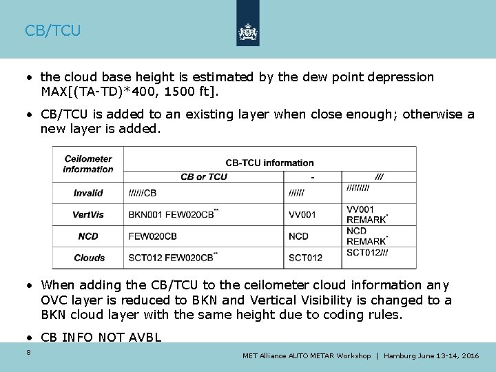
CB/TCU • the cloud base height is estimated by the dew point depression MAX[(TA-TD)*400, 1500 ft]. • CB/TCU is added to an existing layer when close enough; otherwise a new layer is added. • When adding the CB/TCU to the ceilometer cloud information any OVC layer is reduced to BKN and Vertical Visibility is changed to a BKN cloud layer with the same height due to coding rules. • CB INFO NOT AVBL 8 MET Alliance AUTO METAR Workshop | Hamburg June 13 -14, 2016
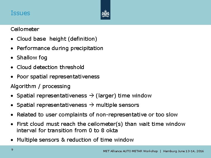
Issues Ceilometer • Cloud base height (definition) • Performance during precipitation • Shallow fog • Cloud detection threshold • Poor spatial representativeness Algorithm / processing • Spatial representativeness (larger) time window • Spatial representativeness multiple sensors • Related to user complaints of non-representative or too slow • First cloud must reach the ceilometer(s) than wait time window interval for transition from 0 to 8 okta • Multiple sensors & reduction of time window 9 MET Alliance AUTO METAR Workshop | Hamburg June 13 -14, 2016
Issues Other information sources • (Sky) camera, pyrometer, pyrgeometer, satellite, radar, … • How to add cloud cover / assign cloud base height • How to handle/select in conflicting situations • Runway dependent cloud for local routine and special report (? ) versus • See also manual overruling / procedures • Usage of remote observations The next slides give some examples 10 MET Alliance AUTO METAR Workshop | Hamburg June 13 -14, 2016
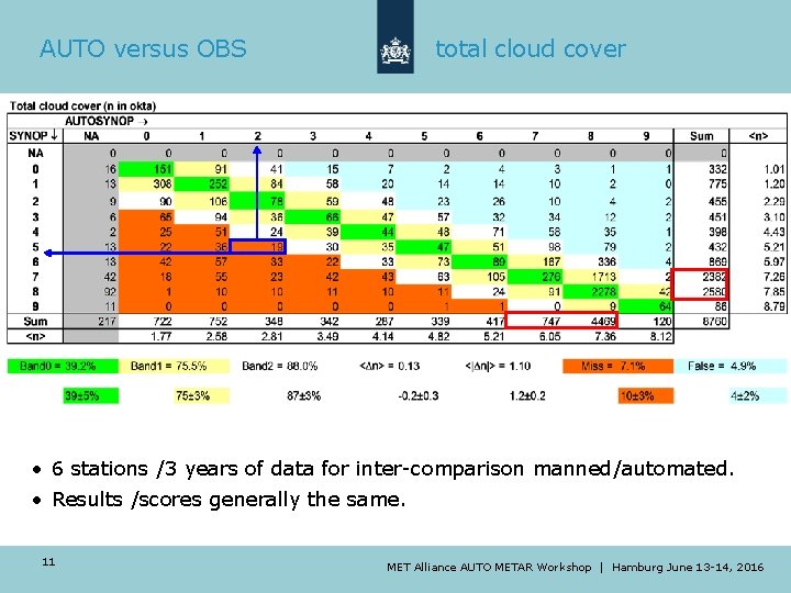
AUTO versus OBS total cloud cover • 6 stations /3 years of data for inter-comparison manned/automated. • Results /scores generally the same. 11 MET Alliance AUTO METAR Workshop | Hamburg June 13 -14, 2016
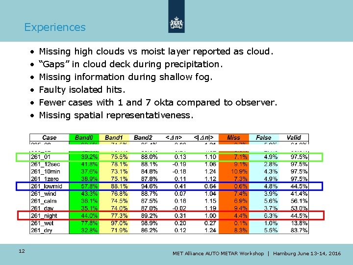
Experiences • • • 12 Missing high clouds vs moist layer reported as cloud. “Gaps” in cloud deck during precipitation. Missing information during shallow fog. Faulty isolated hits. Fewer cases with 1 and 7 okta compared to observer. Missing spatial representativeness. MET Alliance AUTO METAR Workshop | Hamburg June 13 -14, 2016
Ceilometer backscatter 13 precipitation / usage ZV MET Alliance AUTO METAR Workshop | Hamburg June 13 -14, 2016
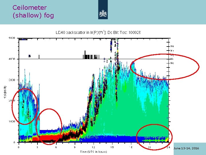
Ceilometer (shallow) fog 14 MET Alliance AUTO METAR Workshop | Hamburg June 13 -14, 2016
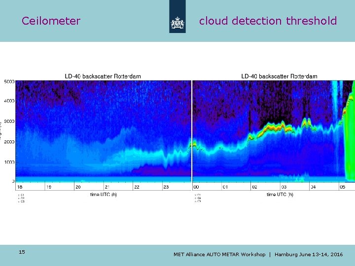
Ceilometer 15 cloud detection threshold MET Alliance AUTO METAR Workshop | Hamburg June 13 -14, 2016
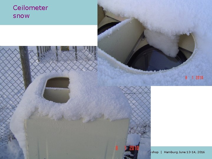
Ceilometer snow 16 MET Alliance AUTO METAR Workshop | Hamburg June 13 -14, 2016
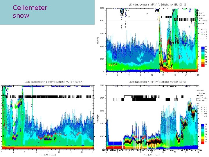
Ceilometer snow 17 MET Alliance AUTO METAR Workshop | Hamburg June 13 -14, 2016
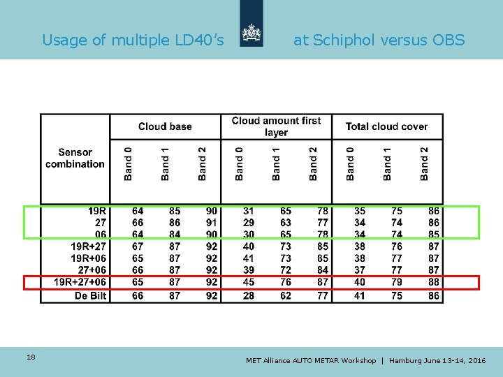
Usage of multiple LD 40’s 18 at Schiphol versus OBS MET Alliance AUTO METAR Workshop | Hamburg June 13 -14, 2016
Ongoing developments Nubi. Scope • Scanning pyrometer • Thermal IR, 8 -14μm • FOV=3° • Scan every 10 minutes • 36 azimuth * 23 elevation angles • Sky temperature cloud mask / coverage 19 METAlliance. AUTOMETARWorkshop| |Hamburg. June 13 -14, 13 - 2016 MET 14, 2016
• Effect of scanning, spatial information • Evaluation: good results for total cloud cover • Many applications require accurate height!? percentage cases in okta interval Ongoing developments Nubi. Scope cover = 0 and 8 ▼ cover = 1 and 7 ▲ cover = 2 to 6 ▲ zenith angle range 20 MET Alliance AUTO METAR Workshop | Hamburg June 13 -14, 2016
Ceilometer Acceptance Test at Cabauw (CAT) Goals: verify performance at CESAR site and assess impact of transition on operational (AUTO) SYNOP/METAR cloud reporting Two CHM 15 k’s at firmware 0. 724 28 Sep 2014– 18 Jan 2015 Reference systems: ALS 450 UV lidar (355 nm) CAELI Raman lidar (355 -532 -1064 nm) Tower visibility sensors 2 -200 m Optimal use of Cabauw facilities as testbed for new operational sensors Cabauw, NL MET Alliance AUTO METAR Workshop | Hamburg June 13 -14, 2016
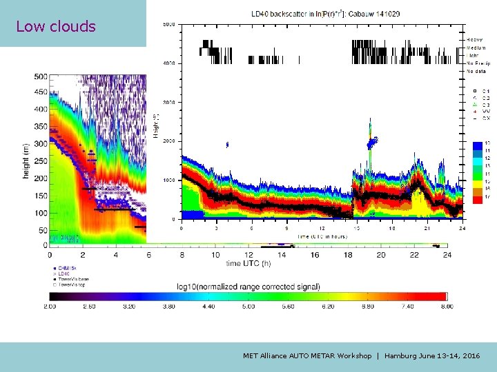
Low clouds MET Alliance AUTO METAR Workshop | Hamburg June 13 -14, 2016
Low clouds Results for low clouds vs FS sensors (2, 10, 20, 40, 80, 140, 200 m) “ 30 m level” (100 ft) “ 110 m level” (360 ft) Percentage Correct CHM 1 46% CHM 1 84% CHM 2 45% CHM 2 82% LD 40 <1% LD 40 20% • Main issue: no physical WMO definition for cloud & cloud base! • LD 40 vs CHM <Δh> -35 to -45 m, consistent with Martucci (2010) • Offset caused by different (internal) cloud detection algorithms • CHM 15 k agrees much better with Tower. Vis retrieved “cloud base” MET Alliance AUTO METAR Workshop | Hamburg June 13 -14, 2016
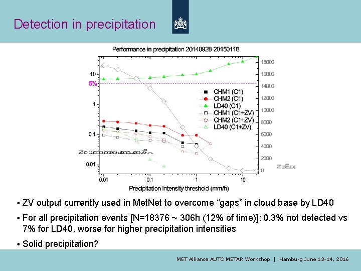
Precipitation Faulty cloud base in precipitation -> firmware updated (2014 -12 -03) MET Alliance AUTO METAR Workshop | Hamburg June 13 -14, 2016
Detection in precipitation ZV output currently used in Met. Net to overcome “gaps” in cloud base by LD 40 For all precipitation events [N=18376 ~ 306 h (12% of time)]: 0. 3% not detected vs 7% for LD 40, worse for higher precipitation intensities Solid precipitation? MET Alliance AUTO METAR Workshop | Hamburg June 13 -14, 2016
Conclusions/Outlook Conclusions from CAT • Lufft CHM 15 k fulfills KNMI requirements ü Much better sensitivity for middle/high level clouds ü Improved consistency between instruments ü For 113 days <Δn> = +10%, but <Δn_low/middle> = +2% ü Offset in cloud height on average 35 -45 m (115 -150 ft) ü Large impact expected on AUTO METAR cloud reporting: lower ceilings (-1 class 25%/-2 classes 5%) ü Ignore ZV (VOR) as cloud base Next steps • Evaluation of CHM 15 k data at Schiphol 06 by observer • Determination of overlap of each sensor individually (May 2016) • Parallel measurements at Cabauw/Vlissingen/De Bilt to assess impact on AUTO METAR and AUTO SYNOP products • Implementation at AWS √ -> airports -> North Sea platforms MET Alliance AUTO METAR Workshop | Hamburg June 13 -14, 2016