Ciencias Sociles LOS ROS MS LARGOS DEL MUNDO


- Slides: 46
Ciencias Soci@les LOS RÍOS MÁS LARGOS DEL MUNDO THE LONGEST RIVERS IN THE WORLD
RÍO AMAZONAS AMAZON RIVER Es el río más largo y más caudaloso del mundo. Nace en Perú, en la Cordillera de los Andes y pasa por Colombia y Brasil, desembocando en el Océano Atlántico. Tiene 7. 062 Km. Francisco de Orellana realizó la primera expedición en 1541. It is the longest and mightiest river in the world. Born in Peru, in the Andes and passes through Colombia and Brazil, flowing into the Atlantic Ocean. It has 7, 062 Km. Francisco de Orellana made the first expedition in 1541.
Pink dolphins and piranhas from the Amazon river. Unión del río Negro con el Amazonas.
Cuenca del Amazonas. Amazon basin
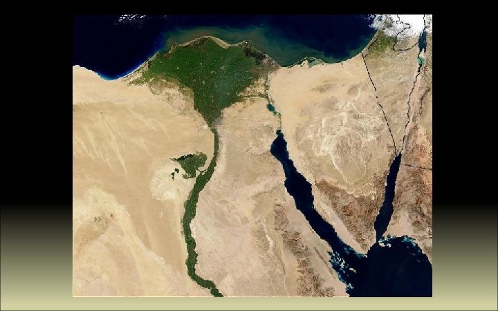
RÍO NILE RIVER Considerado hasta hace poco el más largo del mundo, de 6. 756 km, nace en el Lago Victoria, y tiene dos afluentes principales, el Nilo Blanco, considerado fuente primaria y el Nilo Azul. Atraviesa Uganda, Sudán y Egipto y desemboca en el Mediterráneo en forma de delta. Generally regarded as the longest river in the world, 6, 756 km, 4, 258 miles, is born in Lake Victoria, and has two main tributaries, The White Nile, primary source and the Blue Nile. It flows to North through Uganda, Sudán and Egypt and ends in a large delta into the Mediterranean Sea.
El Cairo
ASWAN Llamada antiguamente Siena. Como el Nilo se desbordaba cada año, Nasser decidió la construcción de una presa que regulara el crecimiento del Nilo. Se empezó a construir en 1960 y se terminó en 1970. La presa mide 5 km. Called Siena in Ancient Egypt. As the Nile flooded every year, Nasser decided to build a dam to regulate the growth of the Nile. Construction began in 1960 and ended in 1970. The dam is 5 km long. Aswan
Pilono y templo de Luxor junto al Nilo.
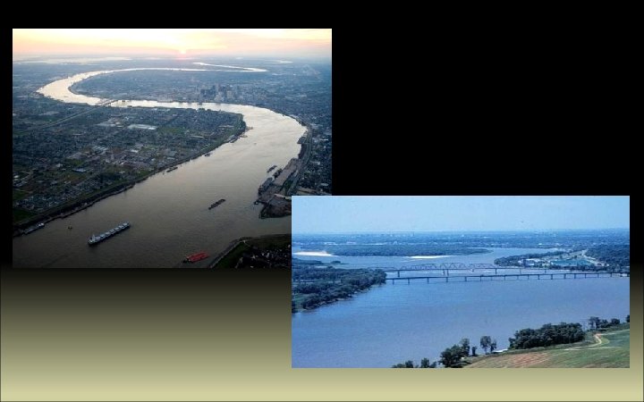
RÍO MISISIPI MISSISSIPI RIVER Significa en alonquino Misi Sipi “Gran Río”. Mide 3. 770 Km y nace en el lago Itasca, Minnesota y desemboca en New Orleans en el Golfo de México. Con su afluente, el Misouri, forman una de las cuencas más grandes del mundo, llegando a alcanzar 6. 270 km. In alonquin language means Misi Sipi “Great river”. It is 3, 770 km long and is born in Lake Itaska, Minnesotta, and flows to the Atlantic Ocean, Mexican Gulf, in New Orleans. With its tributary, the Missouri, form one of the largest basins in the world, reaching 6, 270 km.
El 29 de agosto de 2005, el huracán Katrina devastó la ciudad de Nueva Orleans y las zonas circundantes. On August 29 th, 2005, Hurricane Katrina devastated New Orleans and surrounding areas.
RÍO YANGTSÉ RIVER Conocido también como Yangzi Jiang, es el río más largo de Asia y el tercero del mundo. Mide 6. 300 km. Desemboca en Shanghai. Known in China as the Chang Jiang, is the longest river in Asia and the third-longest in the world. It flows for 6, 300 kilometers to the mouth at Shanghai.
La presa de las Tres Gargantas, construida en Yichang, es la más grande del mundo. Empezó a construirse en 1994 y se terminó en 2010. The Three Gorges dam, built at Yichang, is the largest in the world. The construction was started in 1994 and it was finished in 2010. .
RÍO AMARILLO, HUANG -HE YELLOW RIVER Es el tercer río más largo de Asia. Mide 5. 464 Km. Recorre nueve provincias chinas y desemboca en el Mar de Bohai. Se le conoce como la “ cuna de la civilización china”. El nombre de amarillo se debe al agua con barro que arrastra en el curso bajo del río. It’s the third-longest river in Asia, with a length of 5, 464 Km. It flows through nine Chinese provinces and empties into Bohai Sea. It’s known as “the cradle of Chinese civilisation”. The yellow name is due to color of the muddy water in the lower course of the river
Yellow River crossing Lanzhou Satellite image. Yellow River emptying sediments to Bohai Sea.
El lavado del río Amarillo. Cada año se limpia de sedimentos inyectando agua a 2. 600 metros cúbicos por segundo. Washing the Yellow River. Every year, the river sediments are cleaned, injecting water at 2, 600 cubic meters per second.
RÍO CONGO RIVER Nace en el Lago Bangweulu y mide 4. 380 km. Es el río más profundo, con 220 m. Su primer tramo se conoce como Rio Laulaba y se convierte en el Congo en los rápidos de Boyoma. Su selva es la mayor después de la del Amazonas. Desemboca en el Océano Atlántico. It’s born at Lake Bangweulu and it’s 4, 380 km long. It’s also the world’s deepest river with 200 m or 720 ft. It’s known as Lualaba River and turns into Congo after Boyoma or Stanley Falls. Its forest is the largest after Amazon forest. It flows to the Atlantic Ocean. Cataratas Boyoma/Boyoma Falls.
Río Congo en Kinshasa Selva del Congo/ Congolian forest.
Congo River at Maluku/ El río Congo en Maluku Stanley Pool from satellite.
RÍO MEKONG RIVER Mide 4. 350 km. Nace en la Meseta Tibetana y recorre China, Myanmar, Laos, Thailandia, Camboya and Vietnam, antes de entrar en el Mar del sur de China mediante un complejo delta. Its lengh is 4, 350 km. From the Tibetan Plateau, the river runs through China's Yunnan province, Myanmar, Laos, Thailand, Cambodia and Vietnam, before entering the South China Sea via a complex delta system.
Río Mekong en Yunan, China. Río Mekong en Phnom Penh, Camboya.
Barca de transporte en el Mekong. Delta del Mekong, Vietnam.
RÍO NÍGER NIGER RIVER Con 4. 184 km, es el noveno más largo del mundo. Nace en Guinea Conakry y desemboca en el Golfo de Guinea, en Nigeria. Delta del Níger desde NASA satélite. Niger delta from NASA space shuttle. With 4, 184 km, The Niger is the ninth longest river in the world. From Guinea Conakry, flows to the Atlantic Ocean (Gulf of Guinea).
Río Níger junto a Niamey. Foto: Dominik Schwarz Traditional comunity fishing on the Niger River. Photo Naliaka
Near Kennedy Bridge, Niamey. Fotos Dan y Roland.
RÍO LENA RIVER Es el décimo río más largo del mundo, con 4, 313 km. Nace en los Montes Baikal y desemboca en el Mar de Laptev, en el Ártico. It’s the tenth longest river in the world, with 4, 313 km, from its source at Baikal Mountains to the mouth at Laptev Sea in the Artic Ocean.
Río Lena, cerca de Yakutsk Puerto de Yakutsk. El río Lena está congelado hasta la primavera. Yakutsk harbour. Lena river is frozen untill Spring.
La ciudad de Yakutsk es la más fría del planeta, con temperaturas de hasta -64º. En invierno, el río Lena es una autopista. Yakutsk is considered the coldest city in the world, with temperatures of -64 Cº. In winter, River Lena is used as a motorway.
Los Pilares del Lena o el Bosque de Piedra. Se formaron en el periodo Cámbrico como lecho de un mar. El parque nacional del río Lena se encuentra en la lista de lugares Patrimonio de la Humanidad. Lena Pillars were formed in the Cambrian period sea basin. The Lena Pillars National Park was inscribed on the World Heritage List
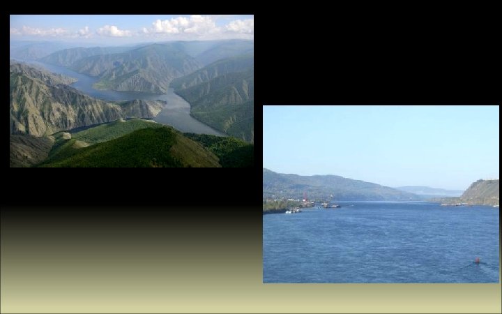
RÍO YENISEI RIVER Es el río más largo de los que desembocan en el Ártico, en el Mar de Kara, en Siberia. Nace en Mongolia, recibe agua del Lago Baikal y mide 4. 093 Km. It’s the longest river flowing to the Artic, to Kara Sea, in Siberia. It’s born in Mongolia and one of its sources is Lake Baikal. It’s 4, 093 Km long.
Es uno de los mayores ríos de Siberia, Rusia. Es el séptimo río más largo del mundo, 3. 650 Km, con su afluente el Irtysh, 5. 400 Km. Nace en los Montes Altai y desemboca en el Ártico, en el estuario más largo del mundo. It’s one of the longest rivers in Siberia, Russia. The seventh longest in the world, with 3, 650 Km, and with its tiburary, Irtysh, it’s 5, 400 Km long. It flows from Altai Mountains to the Artic Ocean in the world’s longest estuary. RÍO OBI OB RIVER
Mounts Altai and Ob river Río Obi congelado/Ob river frozen
Desembocadura/ River Mouth. Río Obi cerca de Barnaul. /Ob river near Barnaul.
Foto satélite de la desembocadura de los ríos Obi y Yenisei.
RÍO VOLGA RIVER Con 3. 692 km, el Volga es el río más largo y caudaloso de Europa. Nace en el centro de Rusia, en las colinas Valdai y desemboca en el Mar Caspio. Es navegable en casi todo su recorrido. With 3, 692 km, The Volga is the longest and largest river in Europe. From Valdai Hills, It flows through central Russia, into the Caspian Sea. It’s navigable.
Puente sobre el Volga en Volgograd. Bridge over the Volga at the city of Vogograd. Delta y depresión del Volga desde satélite
La famosa pintura de Ilya Repin, Los bateleros del Volga. Ilya Repin’s famous painting, The Barge Haulers of the Volga.
Río Volga en las montañas Zhiguli
RÍO YUKÓN YUKON RIVER El río Yukón nace en las montañas Rocosas, en Canadá y después de 3. 190 km, desemboca en el mar de Bering. Su nombre significa Gran Río. Fue el medio de transporte durante la Fiebre del Oro de 1896 a principios del siglo XX. Its source is located in the Rocky Mountains in Canada, in British Columbia. After 3, 190 km, empties into the Bering Sea. Its name means Big River. It was the means of transport during the 1896 Klondike Gold Rush.
Meandros del río Yukón.
RÍO BRAVO RÍO GRANDE Con 3, 051 km, nace en Colorado y desemboca en el Golfo de México. Forma parte de la frontera entre Estados Unidos y México. With 3, 051 km, its source is in Colorado Mountains and flows to The Gulf of Mexico. Along the way, it forms part of the Mexico– United States border. Río Grande en Alburque, Nuevo Mexico.
Cañón de Santa Elena. Texas. Santa Elena Canyon. Texas.
Big Bend National Park, Texas.
Esta presentación tiene únicamente una finalidad cultural, sin ánimo de lucro. Only cultural purpose. Non profit. All rights reserved. Images and maps from the web. (Todas las imágenes son propiedad de sus autores. ) All images belong to their authors) Música: Ol' Man River - William Warfield and MGM chorus(Showboat) Ciencias Soci@les Realización: Carmen Madruga https: //csociales. wordpress. com/ http: //www. slideshare. net/carmadruga/