Chapter 7 Atmospheric Circulations Atmospheric Circulations Scales of

- Slides: 62

Chapter 7 Atmospheric Circulations

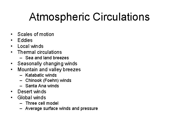
Atmospheric Circulations • • Scales of motion Eddies Local winds Thermal circulations – Sea and land breezes • Seasonally changing winds • Mountain and valley breezes – Katabatic winds – Chinook (Foehn) winds – Santa Ana winds • Desert winds • Global winds – Three cell model – Average surface winds and pressure

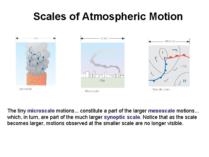
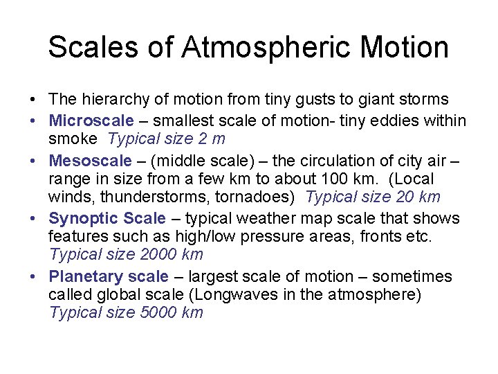
Scales of Atmospheric Motion The tiny microscale motions. . . constitute a part of the larger mesoscale motions. . . which, in turn, are part of the much larger synoptic scale. Notice that as the scale becomes larger, motions observed at the smaller scale are no longer visible.

Scales of Atmospheric Motion • The hierarchy of motion from tiny gusts to giant storms • Microscale – smallest scale of motion- tiny eddies within smoke Typical size 2 m • Mesoscale – (middle scale) – the circulation of city air – range in size from a few km to about 100 km. (Local winds, thunderstorms, tornadoes) Typical size 20 km • Synoptic Scale – typical weather map scale that shows features such as high/low pressure areas, fronts etc. Typical size 2000 km • Planetary scale – largest scale of motion – sometimes called global scale (Longwaves in the atmosphere) Typical size 5000 km

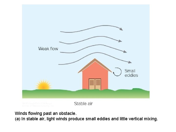
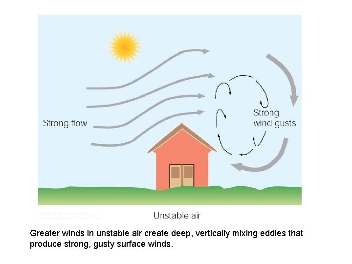
Eddies • When the wind encounters a solid object, a whirl of air or eddy forms on the object’s downwind side. The size and shape of the eddy often depends upon the size and shape of the obstacle and the speed of the wind.

Winds flowing past an obstacle. (a) In stable air, light winds produce small eddies and little vertical mixing.

Greater winds in unstable air create deep, vertically mixing eddies that produce strong, gusty surface winds.

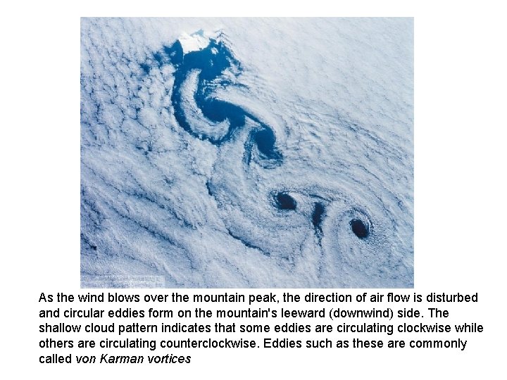
As the wind blows over the mountain peak, the direction of air flow is disturbed and circular eddies form on the mountain's leeward (downwind) side. The shallow cloud pattern indicates that some eddies are circulating clockwise while others are circulating counterclockwise. Eddies such as these are commonly called von Karman vortices

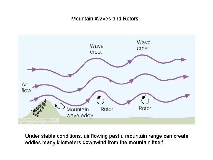
Mountain Waves and Rotors Under stable conditions, air flowing past a mountain range can create eddies many kilometers downwind from the mountain itself.

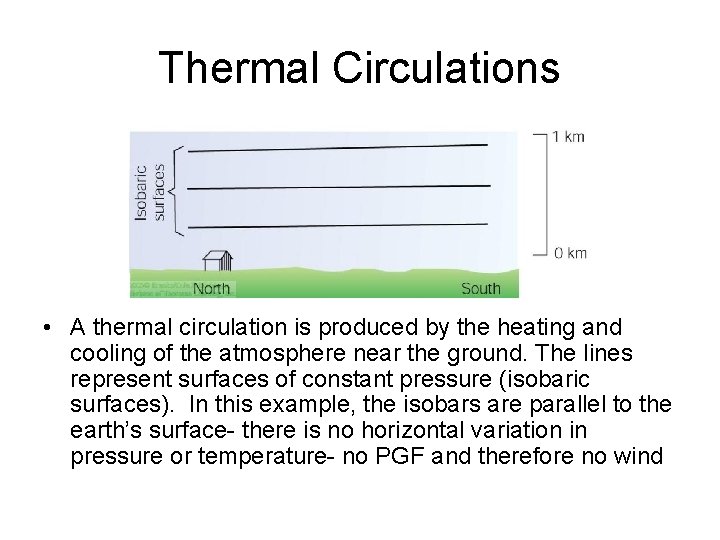
Thermal Circulations • A thermal circulation is produced by the heating and cooling of the atmosphere near the ground. The lines represent surfaces of constant pressure (isobaric surfaces). In this example, the isobars are parallel to the earth’s surface- there is no horizontal variation in pressure or temperature- no PGF and therefore no wind

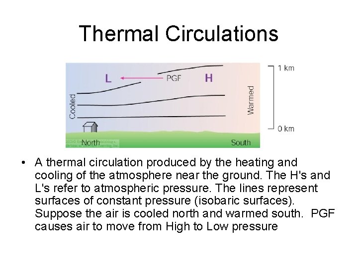
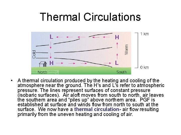
Thermal Circulations • A thermal circulation produced by the heating and cooling of the atmosphere near the ground. The H's and L's refer to atmospheric pressure. The lines represent surfaces of constant pressure (isobaric surfaces). Suppose the air is cooled north and warmed south. PGF causes air to move from High to Low pressure

Thermal Circulations • A thermal circulation produced by the heating and cooling of the atmosphere near the ground. The H's and L's refer to atmospheric pressure. The lines represent surfaces of constant pressure (isobaric surfaces). Air aloft moves from south to north, air leaves the southern area and “piles up” above northern area. PGF is established at surface and winds flow from north to south at the surface. We now have a thermal circulation- air flow resulting primarily from the uneven heating and cooling of air.

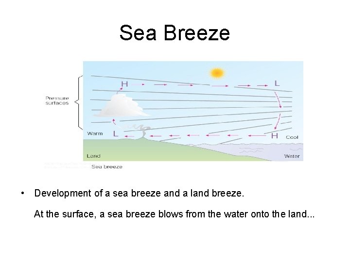
Sea Breeze • Development of a sea breeze and a land breeze. At the surface, a sea breeze blows from the water onto the land. . .

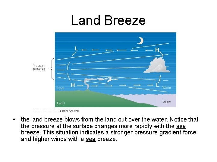
Land Breeze • the land breeze blows from the land out over the water. Notice that the pressure at the surface changes more rapidly with the sea breeze. This situation indicates a stronger pressure gradient force and higher winds with a sea breeze.

Sea Breeze Front • Leading edge of the sea breeze • Produces a rapid drop in temperature just behind it (as much as 9°F) • Cumulus clouds often form along this front • Main cause of Florida’s abundant rainfall

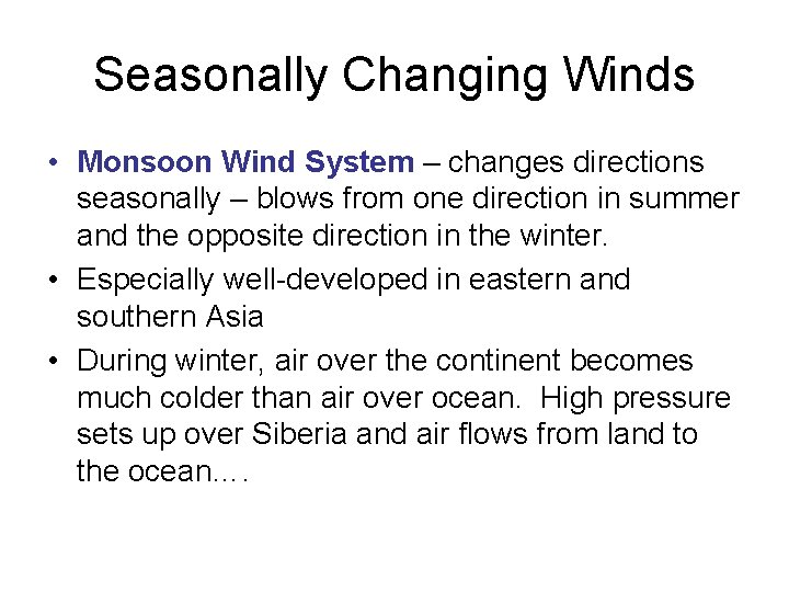
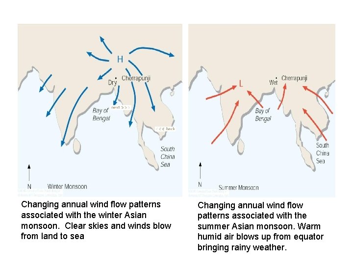
Seasonally Changing Winds • Monsoon Wind System – changes directions seasonally – blows from one direction in summer and the opposite direction in the winter. • Especially well-developed in eastern and southern Asia • During winter, air over the continent becomes much colder than air over ocean. High pressure sets up over Siberia and air flows from land to the ocean….

Changing annual wind flow patterns associated with the winter Asian monsoon. Clear skies and winds blow from land to sea Changing annual wind flow patterns associated with the summer Asian monsoon. Warm humid air blows up from equator bringing rainy weather.

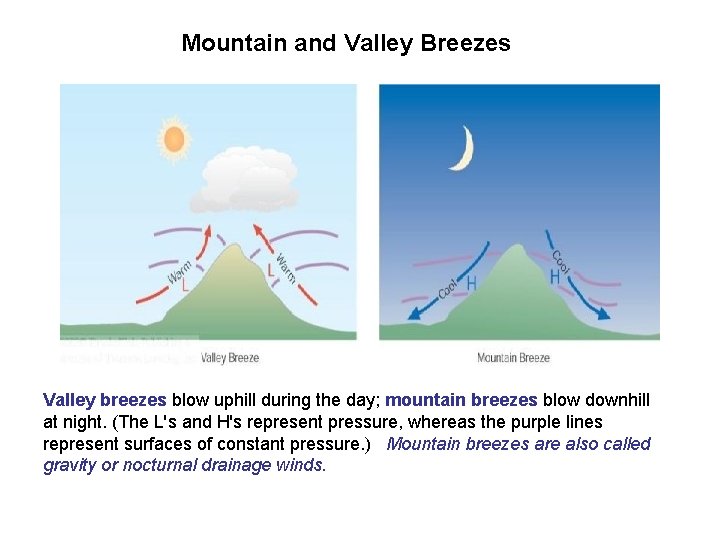
Mountain and Valley Breezes Valley breezes blow uphill during the day; mountain breezes blow downhill at night. (The L's and H's represent pressure, whereas the purple lines represent surfaces of constant pressure. ) Mountain breezes are also called gravity or nocturnal drainage winds.

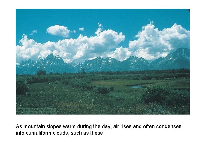
As mountain slopes warm during the day, air rises and often condenses into cumuliform clouds, such as these.

Katabatic Winds • Any downslope wind • Usually reserved for downslope winds that are much stronger than mountain breezes. • Katabatic (or fall) winds can rush down slopes at hurricane speeds, but most are not that intense and many are on the order of 10 kts or less. – Bora – a cold gusty northeasterly wind with speeds sometimes in excess of 100 kts. (Northern Adriatic) – Mistral – cold (less violent wind) that descends the western mountains and into the Rhone Valley of France

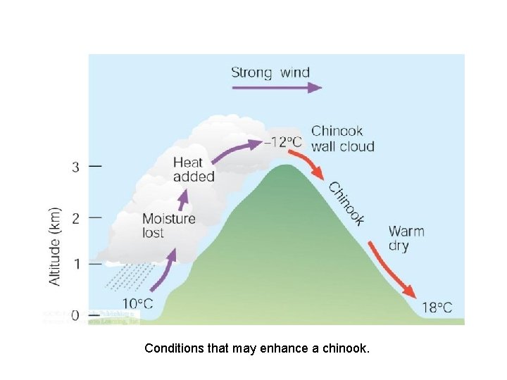
Chinook (Foehn) Winds • Warm dry wind that descends the eastern slope of the Rocky Mountains. • Region of influence extends from NE New Mexico into Canada. (Similar winds occur along the leeward slope of the Alps) • Snow Eater • Occur when strong westerly winds aloft flow over a N-S trending mountain range producing low pressure on the eastern side of the mountains. This trough of low pressure forces air downslope. As the air descends it is compressed and warms. (Compressional heating) See pg 177 of book

Conditions that may enhance a chinook.

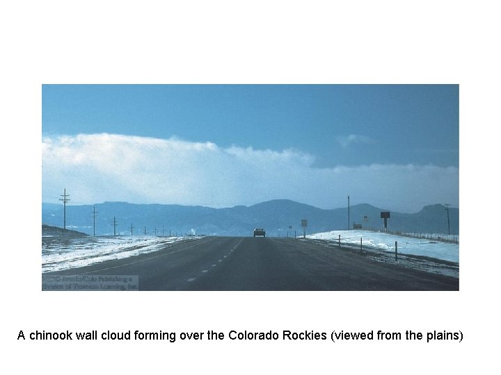
A chinook wall cloud forming over the Colorado Rockies (viewed from the plains)

Santa Ana Winds • Warm dry wind that blows from the east or northeast into Southern California • Air descends from the elevated desert plateau, it funnels through mountain canyons in the San Gabriel and San Bernardino Mountains, finally spreading over the Los Angeles Basin and San Fernando Valley • It lifts dust and sand, dries out vegetation, sets stage for serious brush fires, especially in Fall. (1961 Bel Air Fire burned for 3 days, destroyed 484 homes and caused $25 million in damage.

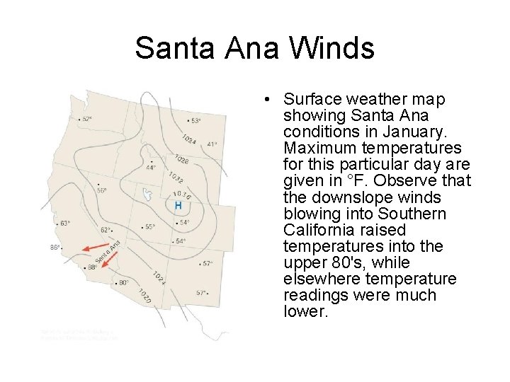
Santa Ana Winds • Surface weather map showing Santa Ana conditions in January. Maximum temperatures for this particular day are given in °F. Observe that the downslope winds blowing into Southern California raised temperatures into the upper 80's, while elsewhere temperature readings were much lower.

Desert Winds • Sandstorms • Haboob • Dust devils (whirlwinds)

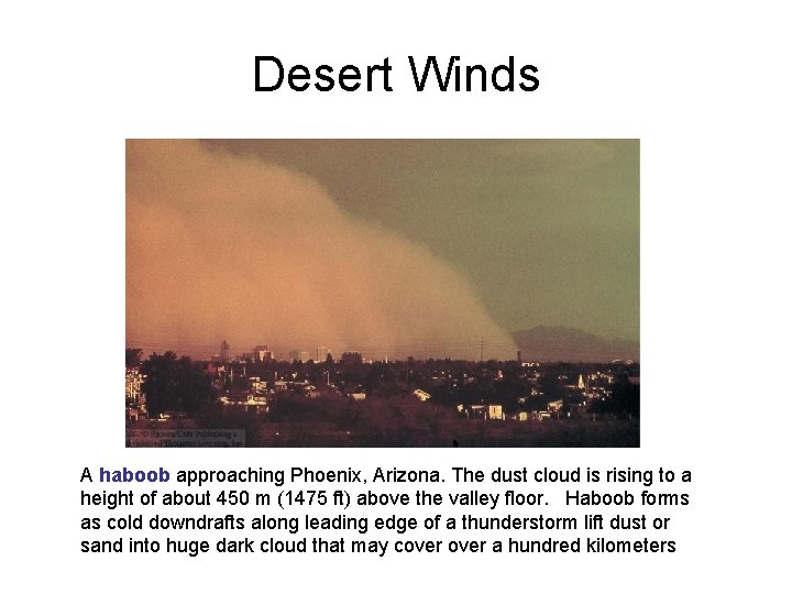
Desert Winds A haboob approaching Phoenix, Arizona. The dust cloud is rising to a height of about 450 m (1475 ft) above the valley floor. Haboob forms as cold downdrafts along leading edge of a thunderstorm lift dust or sand into huge dark cloud that may cover a hundred kilometers

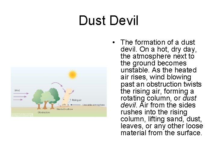
Dust Devil • The formation of a dust devil. On a hot, dry day, the atmosphere next to the ground becomes unstable. As the heated air rises, wind blowing past an obstruction twists the rising air, forming a rotating column, or dust devil. Air from the sides rushes into the rising column, lifting sand, dust, leaves, or any other loose material from the surface.

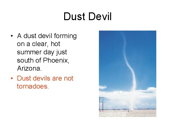
Dust Devil • A dust devil forming on a clear, hot summer day just south of Phoenix, Arizona. • Dust devils are not tornadoes.

General Circulation of the Atmosphere • Represents the average air flow around the world • Actual winds at any one place may vary considerably from average • Model for how heat is transported from the equator to the poles • Underlying cause is the unequal heating of earth’s surface

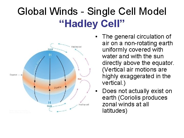
Global Winds - Single Cell Model “Hadley Cell” • The general circulation of air on a non-rotating earth uniformly covered with water and with the sun directly above the equator. (Vertical air motions are highly exaggerated in the vertical. ) • Does not actually exist on earth (Coriolis produces zonal winds at all latitudes)

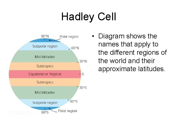
Hadley Cell • Diagram shows the names that apply to the different regions of the world and their approximate latitudes.

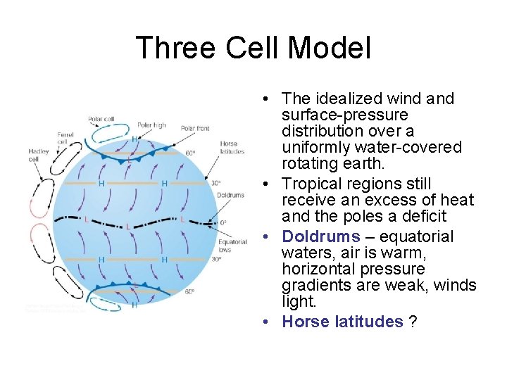
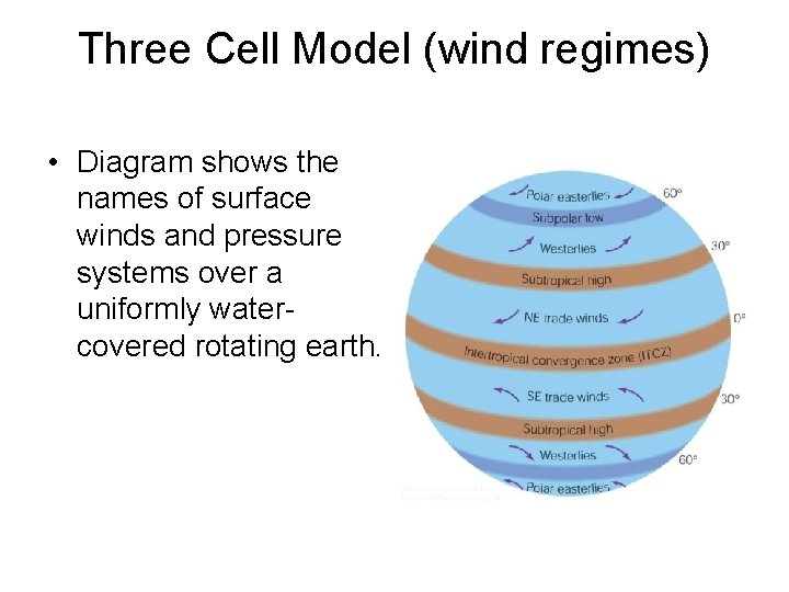
Three Cell Model • The idealized wind and surface-pressure distribution over a uniformly water-covered rotating earth. • Tropical regions still receive an excess of heat and the poles a deficit • Doldrums – equatorial waters, air is warm, horizontal pressure gradients are weak, winds light. • Horse latitudes ?

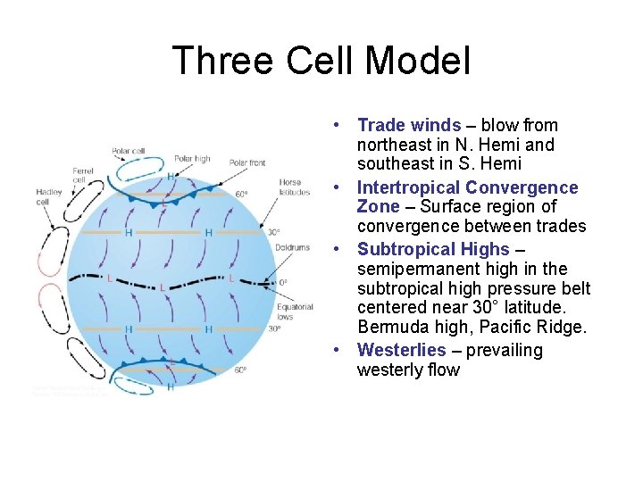
Three Cell Model • Trade winds – blow from northeast in N. Hemi and southeast in S. Hemi • Intertropical Convergence Zone – Surface region of convergence between trades • Subtropical Highs – semipermanent high in the subtropical high pressure belt centered near 30° latitude. Bermuda high, Pacific Ridge. • Westerlies – prevailing westerly flow

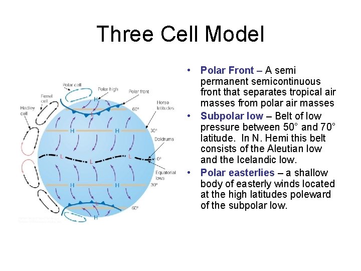
Three Cell Model • Polar Front – A semi permanent semicontinuous front that separates tropical air masses from polar air masses • Subpolar low – Belt of low pressure between 50° and 70° latitude. In N. Hemi this belt consists of the Aleutian low and the Icelandic low. • Polar easterlies – a shallow body of easterly winds located at the high latitudes poleward of the subpolar low.

Three Cell Model (wind regimes) • Diagram shows the names of surface winds and pressure systems over a uniformly watercovered rotating earth.

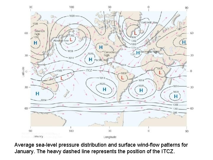
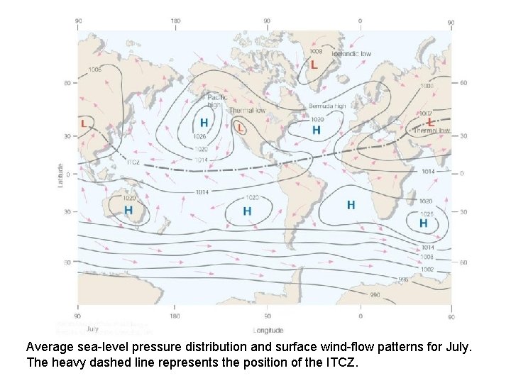
Semi-permanent pressure systems • Highs and Lows that move only slightly during the course of the year • Bermuda High (Atlantic) • Pacific High or Pacific Ridge • Greenland-Icelandic Low or Icelandic Low • Aleutian Low

Average sea-level pressure distribution and surface wind-flow patterns for January. The heavy dashed line represents the position of the ITCZ.

Average sea-level pressure distribution and surface wind-flow patterns for July. The heavy dashed line represents the position of the ITCZ.

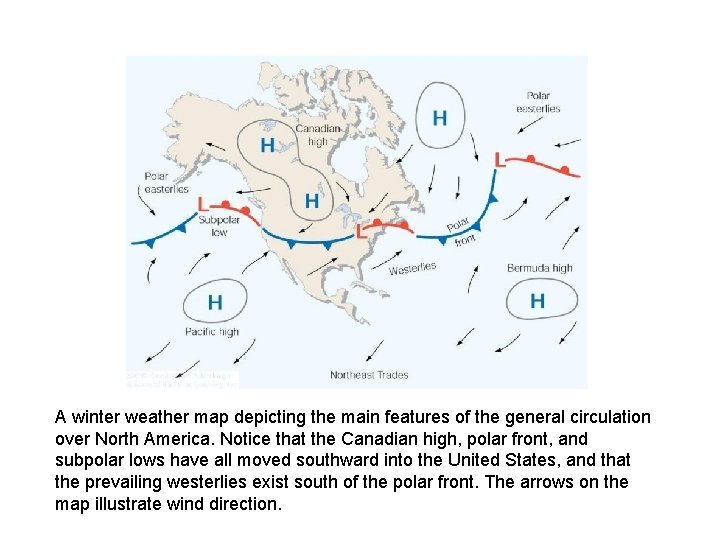
A winter weather map depicting the main features of the general circulation over North America. Notice that the Canadian high, polar front, and subpolar lows have all moved southward into the United States, and that the prevailing westerlies exist south of the polar front. The arrows on the map illustrate wind direction.

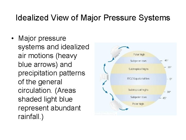
Idealized View of Major Pressure Systems • Major pressure systems and idealized air motions (heavy blue arrows) and precipitation patterns of the general circulation. (Areas shaded light blue represent abundant rainfall. )

General Circulation and Precipitation • The position of the major features of the general circulation and their latitudinal displacement strongly influence the climate of many areas. • In general we expect abundant rainfall where air rises (tropics and ITCZ) very little where it sinks (vicinty of subtropical highs and polar regions).

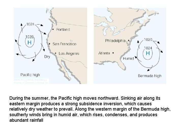
During the summer, the Pacific high moves northward. Sinking air along its eastern margin produces a strong subsidence inversion, which causes relatively dry weather to prevail. Along the western margin of the Bermuda high, southerly winds bring in humid air, which rises, condenses, and produces abundant rainfall

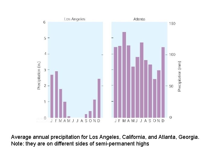
Average annual precipitation for Los Angeles, California, and Atlanta, Georgia. Note: they are on different sides of semi-permanent highs

Westerly winds and the Jet Stream • Relatively strong winds concentrated within a narrow band in the atmosphere. • Nearly continuous • Jet Core often exceeds 100 kts • Found at the tropopause at elevations between 33, 000 and 46, 000 ft, but may occur at higher and lower altitudes.

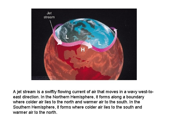
A jet stream is a swiftly flowing current of air that moves in a wavy west-toeast direction. In the Northern Hemisphere, it forms along a boundary where colder air lies to the north and warmer air to the south. In the Southern Hemisphere, it forms where colder air lies to the south and warmer air to the north.

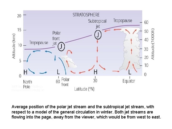
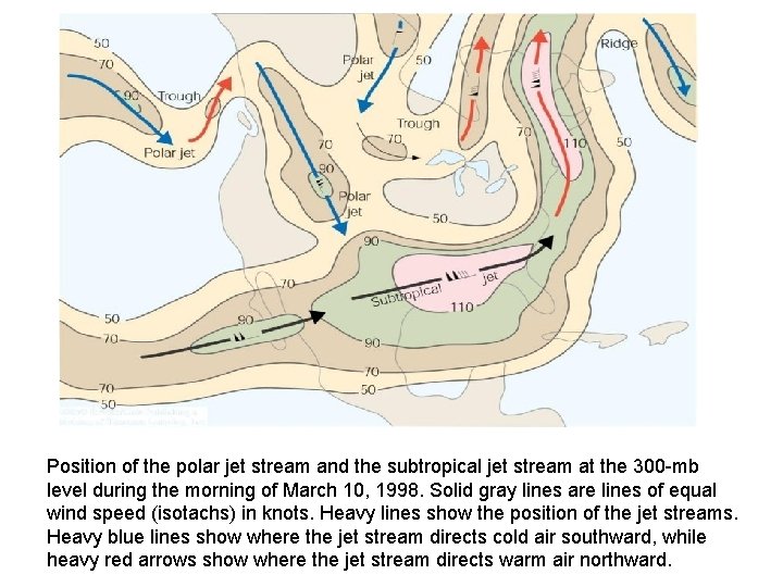
Jet Streams • Subtropical jet stream – the jet stream typically found between 20° and 30° latitude and at altitudes between 12 and 14 km. • Polar front jet stream (Polar jet) – the jet stream that is associated with the polar front in middle and high latitudes. Usually located between 9 and 12 km. • Low level jets – peak winds less than 60 kts that form above the Central Plains during the summer- contributes to thunderstorm activity • Tropical easterly jet – summertime – over tropics • Stratospheric polar jet – forms in the polar winter near the top of the stratosphere

Average position of the polar jet stream and the subtropical jet stream, with respect to a model of the general circulation in winter. Both jet streams are flowing into the page, away from the viewer, which would be from west to east.

Position of the polar jet stream and the subtropical jet stream at the 300 -mb level during the morning of March 10, 1998. Solid gray lines are lines of equal wind speed (isotachs) in knots. Heavy lines show the position of the jet streams. Heavy blue lines show where the jet stream directs cold air southward, while heavy red arrows show where the jet stream directs warm air northward.

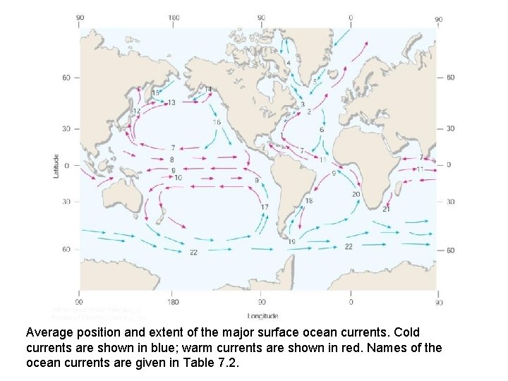
Global Wind Patterns and the Oceans • Winds blowing over the oceans cause the surface water to drift along. • The general atmospheric circulation influences the ocean currents. • Ocean currents move with the prevailing wind. • Gulf stream, California current, etc.

Average position and extent of the major surface ocean currents. Cold currents are shown in blue; warm currents are shown in red. Names of the ocean currents are given in Table 7. 2.

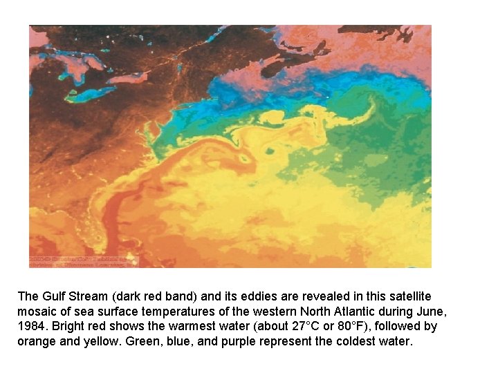
The Gulf Stream (dark red band) and its eddies are revealed in this satellite mosaic of sea surface temperatures of the western North Atlantic during June, 1984. Bright red shows the warmest water (about 27°C or 80°F), followed by orange and yellow. Green, blue, and purple represent the coldest water.

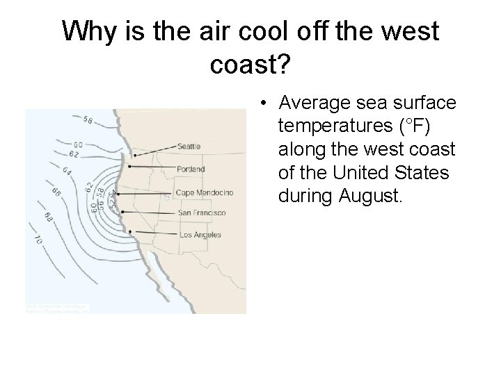
Why is the air cool off the west coast? • Average sea surface temperatures (°F) along the west coast of the United States during August.

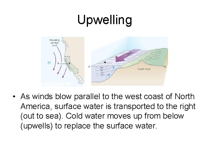
Upwelling • As winds blow parallel to the west coast of North America, surface water is transported to the right (out to sea). Cold water moves up from below (upwells) to replace the surface water.

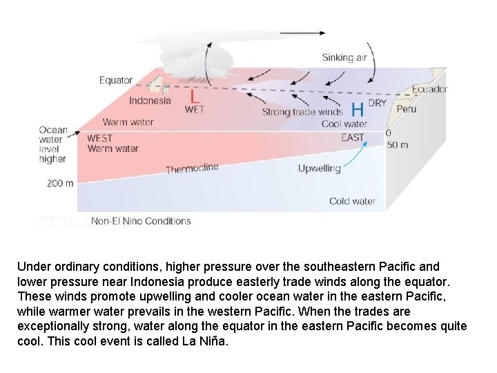
Under ordinary conditions, higher pressure over the southeastern Pacific and lower pressure near Indonesia produce easterly trade winds along the equator. These winds promote upwelling and cooler ocean water in the eastern Pacific, while warmer water prevails in the western Pacific. When the trades are exceptionally strong, water along the equator in the eastern Pacific becomes quite cool. This cool event is called La Niña.

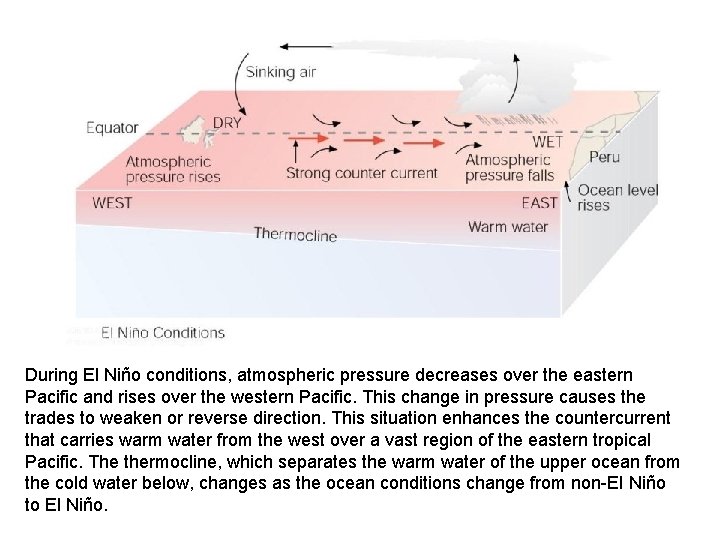
During El Niño conditions, atmospheric pressure decreases over the eastern Pacific and rises over the western Pacific. This change in pressure causes the trades to weaken or reverse direction. This situation enhances the countercurrent that carries warm water from the west over a vast region of the eastern tropical Pacific. The thermocline, which separates the warm water of the upper ocean from the cold water below, changes as the ocean conditions change from non-El Niño to El Niño.

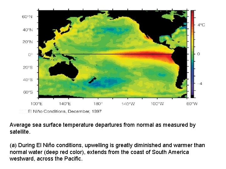
Average sea surface temperature departures from normal as measured by satellite. (a) During El Niño conditions, upwelling is greatly diminished and warmer than normal water (deep red color), extends from the coast of South America westward, across the Pacific.

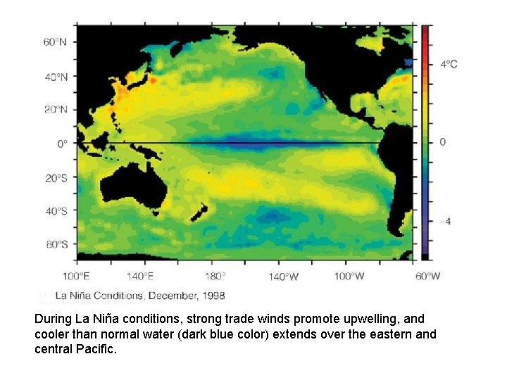
During La Niña conditions, strong trade winds promote upwelling, and cooler than normal water (dark blue color) extends over the eastern and central Pacific.

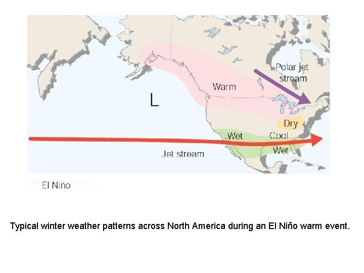
Typical winter weather patterns across North America during an El Niño warm event.

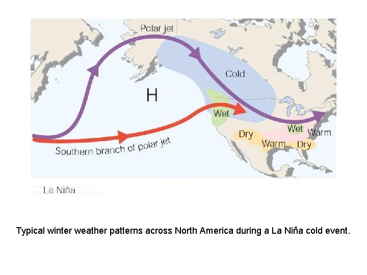
Typical winter weather patterns across North America during a La Niña cold event.

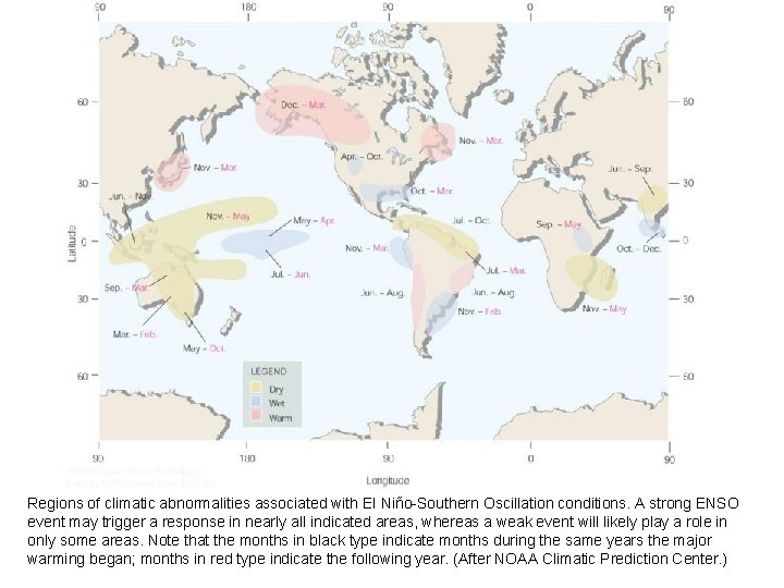
Regions of climatic abnormalities associated with El Niño-Southern Oscillation conditions. A strong ENSO event may trigger a response in nearly all indicated areas, whereas a weak event will likely play a role in only some areas. Note that the months in black type indicate months during the same years the major warming began; months in red type indicate the following year. (After NOAA Climatic Prediction Center. )
