Chapter 6 Climate and Terrestrial Biodiversity Chapter Overview

Chapter 6 Climate and Terrestrial Biodiversity

Chapter Overview Questions Ø What factors the earth’s climate? Ø How does climate determine where the earth’s major biome’s are found? Ø What are the major types of desert biomes? Ø What are the major types of grassland biomes?
 Ø What are the major types of forest and mountain")
Chapter Overview Questions (cont’d) Ø What are the major types of forest and mountain biomes? Ø How have human activities affected the world’s desert, grassland, forest, and mountain biomes?

Weather & Climate Differences between weather and climate: • • • weather: short–term atmospheric conditions that include: temperature, pressure, humidity, precipitation, solar radiation, cloud cover, wind direction and speed. climate: long–term weather of a region. global temperature and precipitation patterns are determined by uneven heating of Earth by Sun and lead to distinct climate zones according to latitude. © Brooks/Cole Publishing Company / ITP

Ø The atmosphere is divided into layers based upon the vertical temperature profile. However, there are no distinct lines or boundaries where one layer ends and the other begins.

National Geographic Video Ø National Geographic Channel Videos: Origins of the Atmosphere Ø https: //www. youtube. com/watch? v=1 YAOT 92 wu. D 8

Earth’s Current Climate Zones Figure 5 -2

Global Patterns Major factors influencing climate: • • Incoming solar radiation patterns: leads to uneven heating of troposphere from beneath; Air circulation patterns: determined by - • uneven heating of Earth's surface seasonal changes due to Earth's tilt on axis and revolution about the sun Earth's rotation on its axis Ocean currents - influenced by factors that influence air circulation plus differences in water density. © Brooks/Cole Publishing Company / ITP

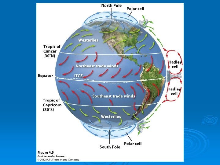
Convection Cells Ø Heat and moisture are distributed over the earth’s surface by vertical currents, which form six giant convection cells at different latitudes. Figure 5 -6

Animation: Climate and Ocean Currents Map PLAY ANIMATION

Animation: Air Circulation and Climate PLAY ANIMATION

Solar Energy and Global Air Circulation: Distributing Heat Ø Global air circulation is affected by the uneven heating of the earth’s surface by solar energy, seasonal changes in temperature and precipitation. Figure 5 -3
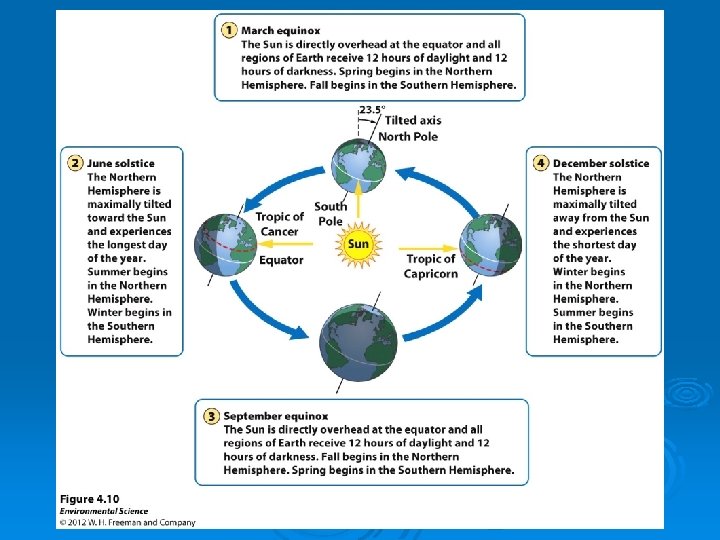
 Winter (northern hemisphere 23. 5 ° tilts away")
Spring (sun aims directly at equator) Winter (northern hemisphere 23. 5 ° tilts away from sun) Solar radiation Summer (northern hemisphere tilts toward sun) Fall (sun aims directly at equator) Fig. 5 -3, p. 102

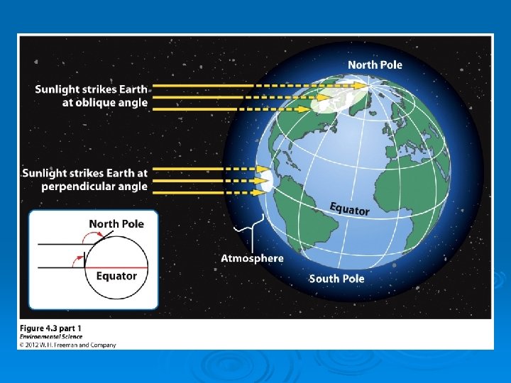
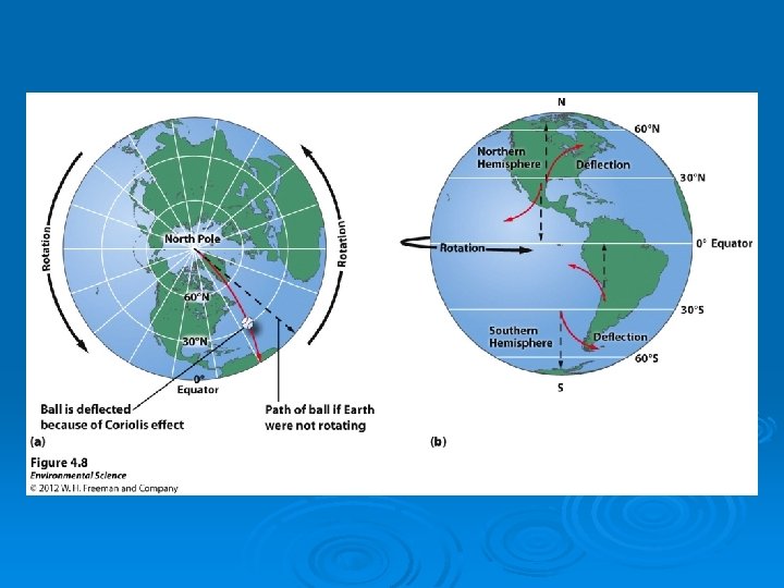
Coriolis Effect Ø Global air circulation is affected by the rotation of the earth on its axis. Figure 5 -4

Cold deserts Westerlies Northeast trades Forests Hot deserts Forests Equator Southeast trades Westerlies Hot deserts Forests Cold deserts Fig. 5 -4, p. 102

Convection Currents Ø Global air circulation is affected by the properties of air water, and land. Figure 5 -5

LOW PRESSURE Cool, dry air HIGH PRESSURE Heat released radiates to space Condensation Falls, is compressed, warms and precipitation Rises, expands, cools Warm, dry air Hot, wet air Flows toward low pressure, picks up moisture and heat HIGH Moist surface warmed PRESSURE by sun LOW PRESSURE Fig. 5 -5, p. 103

Convection Cells Ø Heat and moisture are distributed over the earth’s surface by vertical currents, which form six giant convection cells at different latitudes. Figure 5 -6

Air Circulation Patterns Major patterns: • Air circulation is driven by solar energy • Low & high air pressure: - low pressure: warm and low density. Leads to high rainfall as air rises. - high pressure: cool and dense air. Results in deserts as dry air descends © Brooks/Cole Publishing Company / ITP

Air Circulation Patterns Prevailing winds include westerlies at temperate latitudes, trade winds in the subtropics, & doldrums (stiller air) along the equator. Fig. 7– 4 © Brooks/Cole Publishing Company / ITP
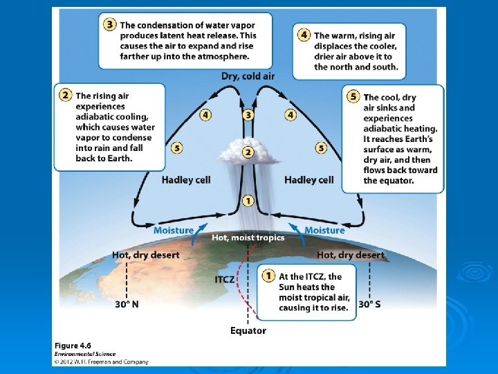
 Ø Area near equator where north and south trades winds")
Intertropical Convergence Zone (ITCZ) Ø Area near equator where north and south trades winds meet Ø Located where two converging Hadley cells are located Ø Moves slightly north and south with changing seasons Ø Typified by dense clouds and intense thunderstorms

ITCZ marked by band of storms along the equator The ITCZ moves farther away from the equator during the Northern summer than the Southern one due to the North-heavy arrangement of the continents

Upwelling The replacement of outgoing surface water with deep, cold, nutrient–rich bottom waters. Leads to increased primary productivity, with large populations of phytoplankton, zooplankton, fish, and fish–eating birds. Fig. 7– 7 © Brooks/Cole Publishing Company / ITP
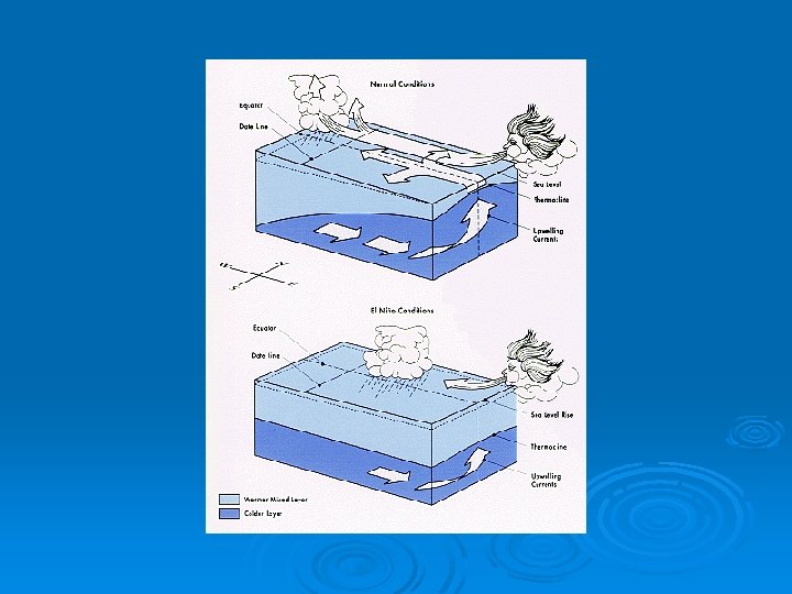
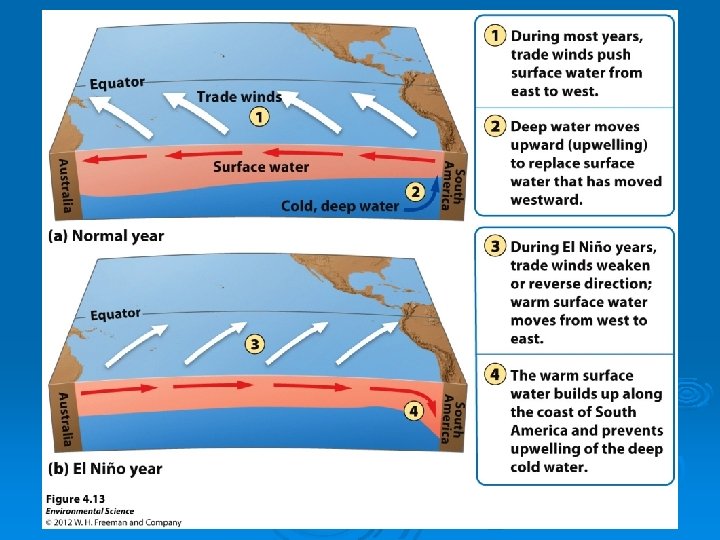
 Ø Ø Ø Normal shore upwellings are affected by changes")
El Niño–Southern Oscillation (ENSO) Ø Ø Ø Normal shore upwellings are affected by changes in climate patterns called the ENSO Trade winds weaken or cease Surface water along the equatorial Pacific Ocean becomes warmer Normal upwellings are suppressed, causing decline in some fish populations Strong ENSOs can trigger extreme weather changes over at least 2/3 of globe, especially in lands along the Pacific and Indian Oceans © Brooks/Cole Publishing Company / ITP

What happens during El Niño? Ø Ø Ø Easterly wind weakens, equatorial upwelling is suppressed. Thermocline “flattens, ” warm surface water surges eastward. Nutrient supply from cold, deeper water is not tapped. Easterly wind retreats, westerly wind pushes convection cell to east of the International Date Line Displacement of convection cell causes change in traditional rainfall patterns and release of large amounts of latent heat into atmosphere. Subsequent energy propagates within atmosphere, affecting weather in various ways and places, disrupting normal rhythm of life across the Pacific
 Fig. 7– 8 © Brooks/Cole Publishing Company / ITP")
El Niño–Southern Oscillation (ENSO) Fig. 7– 8 © Brooks/Cole Publishing Company / ITP

Animation: El Niño Southern Oscillation PLAY ANIMATION
 & La Nina (Bottom: 2/99).")
Credit: © Science VU/NASA/JPL/Visuals Unlimited El Nino (Top: 11/97) & La Nina (Bottom: 2/99). 228923

What is La Niña? Unusually cold ocean temps in the Equatorial Pacific Ø Results in more Atlantic Ocean hurricanes Ø Colder winters in Canada and Northeast Ø Warmer and drier winters in southeastern and southwestern US Ø Wetter winter in Pacific Northwest Ø Torrential rains in SE Asia Ø Lower wheat yields in Argentina Ø More fires in Florida Ø

Ocean Currents: Distributing Heat and Nutrients Ø Ocean currents influence climate by distributing heat from place to place and mixing and distributing nutrients. Figure 5 -7
 Rays of sunlight penetrate the lower atmosphere and warm the earth's surface. (b)")
(a) Rays of sunlight penetrate the lower atmosphere and warm the earth's surface. (b) The earth's surface absorbs much of the incoming solar radiation and degrades it to longer-wavelength infrared (IR) radiation, which rises into the lower atmosphere. Some of this IR radiation escapes into space as heat, and some is absorbed by molecules of greenhouse gases and emitted as even longer-wavelength IR radiation, which warms the lower atmosphere. (c) As concentrations of greenhouse gases rise, their molecules absorb and emit more infrared radiation, which adds more heat to the lower atmosphere. Fig. 5 -7, p. 104

Animation: Greenhouse Effect PLAY ANIMATION

Animation: Increasing Greenhouse Gases PLAY ANIMATION

Ocean Currents: Distributing Heat and Nutrients Ø Global warming: l Considerable scientific evidence and climate models indicate that large inputs of greenhouse gases from anthropogenic activities into the troposphere can enhance the natural greenhouse effect and change the earth’s climate in your lifetime.

Topography and Local Climate: Land Matters Ø Interactions between land oceans and disruptions of airflows by mountains and cities affect local climates. Figure 5 -8

Prevailing winds pick up moisture from an ocean. On the windward side of a mountain range, air rises, cools, and releases moisture. On the leeward side of the mountain range, air descends, warms, and Releases little moisture. Dry habitats Moist habitats Fig. 5 -8, p. 105

Animation: Coastal Breezes PLAY ANIMATION

BIOMES: CLIMATE AND LIFE ON LAND Ø Different climates lead to different communities of organisms, especially vegetation. l l Biomes – large terrestrial regions characterized by similar climate, soil, plants, and animals. Each biome contains many ecosystems whose communities have adapted to differences in climate, soil, and other environmental factors.

BIOMES: CLIMATE AND LIFE ON LAND Figure 5 -9
 Temperate grassland")
Tropic of Cancer Equator High mountains Polar ice Polar grassland (arctic tundra) Temperate grassland Tropical grassland (savanna) Chaparral Coniferous forest Temperate deciduous forest Tropical forest Desert Tropic of Capricorn Fig. 5 -9, p. 106

A variety of factors determine the biome • The biome in an area depends on a variety of abiotic factors – Temperature, precipitation, atmospheric circulation, soil • Climatographs – A climate diagram showing an area’s mean monthly temperature and precipitation – Similar biomes occupy similar latitudes

ld Co Polar Tundra Subpolar Temperate Coniferous forest Grassland Chaparral Hot Deciduous Forest Desert W et Rain forest Savanna Tropical seasonal forest Tropical Desert y Dr Scrubland Fig. 5 -10, p. 107

Aquatic systems have biomelike patterns • Various aquatic systems comprise distinct communities – Coastlines, continental shelves – Open ocean, deep sea – Coral reefs, kelp forests • Aquatic systems are shaped by – Water temperature, salinity, and dissolved nutrients – Wave action, currents, depth – Substrate type, and animal and plant life
 Coniferous Forest Latitude Deciduous Forest")
Elevation Mountain ice and snow Tundra (herbs, lichens, mosses) Coniferous Forest Latitude Deciduous Forest Tropical Forest Deciduous Coniferous Tundra (herbs, Forest lichens, mosses) Polar ice and snow Fig. 5 -11, p. 108

Temperate deciduous forest • Deciduous trees lose their leaves each fall and remain dormant during winter • Mid-latitude forests in Europe, East China, Eastern North America • Fertile soils • Forests = oak, beech, maple

Temperate grasslands • More extreme temperature difference between winter and summer • Less precipitation • Also called steppe or prairie – Once widespread throughout parts of North and South America and much of central Asia – Much was converted for agriculture – Bison, prairie dogs, antelope, and groundnesting birds

Temperate rainforest • Coastal Pacific Northwest region • Great deal of precipitation • Coniferous trees: cedar, spruce, hemlock, fir • Moisture-loving animals – Banana slug • The fertile soil is susceptible to erosion and landslides • Provides lumber and paper

Tropical rainforest • Central America, South America, southeast Asia, and west Africa • Year-round rain and warm temperatures • Dark and damp • Lush vegetation • Variety of animals and tree species, but in low numbers • Very poor, acidic soils

Tropical dry forest • Tropical deciduous forest • India, Africa, South America, northern Australia • Wet and dry seasons • Warm, but less rainfall • Converted to agriculture • Erosion-prone soil

Savanna • Grassland interspersed with trees • Africa, South America, Australia, India • Precipitation only during rainy season • Water holes • Zebras, gazelles, giraffes, lions, hyenas
 •")
Desert • Minimal precipitation • Some deserts are bare, with sand dunes (Sahara) • Some deserts are heavily vegetated (Sonoran) • They are not always hot – Temperatures vary widely • Saline soils • Nocturnal or nomadic animals • Plants have thick skins or spines

Tundra • Canada, Scandinavia, Russia • Minimal precipitation – Nearly as dry as a desert • Seasonal variation in temperature – Extremely cold winters • Permafrost: permanently frozen soil • Few animals: polar bears, musk oxen, caribou • Lichens and low vegetation with few trees
 • Canada, Alaska, Russia, Scandinavia • Variation in temperature and precipitation")
Boreal forest (taiga) • Canada, Alaska, Russia, Scandinavia • Variation in temperature and precipitation • Cool and dry climate – Long, cold winters – Short, cool summers • Poor and acidic soil • Few evergreen tree species • Moose, wolves, bears, migratory birds

Chaparral • Mediterranean Sea, California, Chile, and southern Australia • High seasonal – Mild, wet winters – Warm, dry summers • Frequent fires • Densely thicketed, evergreen shrubs

Altitudes create patterns • Vegetative communities change along mountain slopes – In the Andes, a mountain climber would begin in the tropics and end up in a glacier Hiking up a mountain in the southwest U. S. is analogous to walking from Mexico to Canada

Conclusion • Biomes and communities help us understand how the world functions and how • Species interactions affect communities – Predation, parasitism, competition, mutualism • Humans have altered many communities • Ecological restoration attempts to undo the negative changes that we have caused

HUMAN IMPACTS ON TERRESTRIAL BIOMES Ø Human activities have damaged or disturbed more than half of the world’s terrestrial ecosystems. Ø Humans have had a number of specific harmful effects on the world’s deserts, grasslands, forests, and mountains.

Natural Capital Degradation Desert Large desert cities Soil destruction by off-road vehicles Soil salinization from irrigation Depletion of groundwater Land disturbance and pollution from mineral extraction Fig. 5 -26, p. 123

Natural Capital Degradation Grasslands Conversion to cropland Release of CO 2 to atmosphere from grassland burning Overgrazing by livestock Oil production and off-road vehicles in arctic tundra Fig. 5 -27, p. 123

Natural Capital Degradation Forests Clearing for agriculture, livestock grazing, timber, and urban development Conversion of diverse forests to tree plantations Damage from off-road vehicles Pollution of forest streams Fig. 5 -28, p. 124

Natural Capital Degradation Mountains Agriculture Timber extraction Mineral extraction Hydroelectric dams and reservoirs Increasing tourism Urban air pollution Increased ultraviolet radiation from ozone depletion Soil damage from off-road vehicles Fig. 5 -29, p. 124

Perspectives on Geographical Ecology • Things to remember: - everything is connected; - temperature and precipitation patterns result from interplay of incoming solar radiation and Earth's rotation - temperature and precipitation are major determinants of the distribution of organisms © Brooks/Cole Publishing Company / ITP
- Slides: 70