CHAPTER 5 MATERIALS PAVEMENTS BY DR NOR FAIZAH

CHAPTER 5 MATERIALS & PAVEMENTS BY : DR NOR FAIZAH BT BAWADI 0125943574 norfaizah@unimap. edu. my

Important Date OEL Submission Report 23 rd April 2018 Mid Term Examination 2 3 rd May 2018 (LAB HOURS)
 Soil Materials § Soil characteristics § Basic engineering properties of soils")
Lecture Outlines: 1) Soil Materials § Soil characteristics § Basic engineering properties of soils § Classification of soils for highway use § Soil surveys for highway construction § Soil compaction § California Bearing Ratio (CBR) Test 2) Bituminous Materials § Sources of asphalt § Description and uses of bituminous binders § Properties of asphalt materials § Tests for asphalt materials § Asphalt mixtures § Super-pave systems

PART A: SOIL MATERIALS

Why we need to learn soil materials in pavement? ? ?

INTRODUCTION § Soil properties - importance when a highway is to carry high traffic volumes with a large percentage of trucks. § Importance when high embankments – constructed and when the soil is to be strengthen and used as intermediate support for the highway pavement. § Origin and formation of soils, soil identification, and soil testing methods.

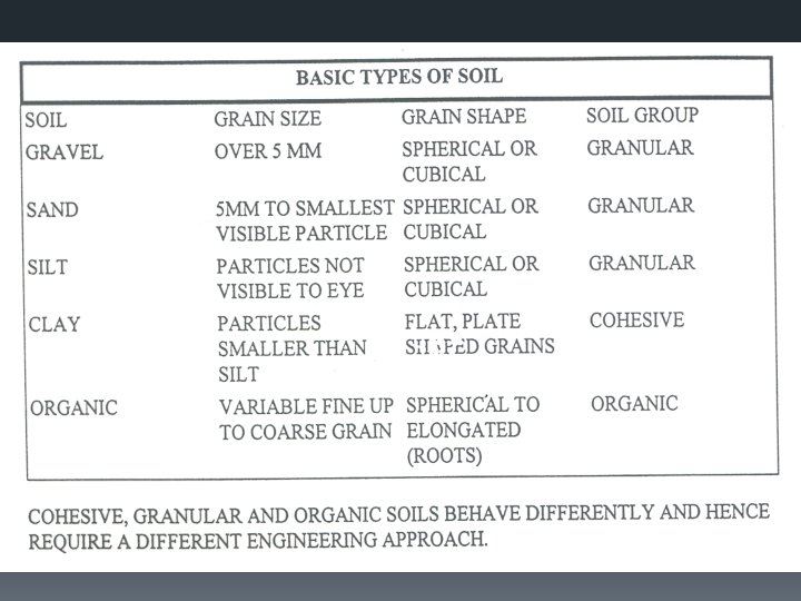
SOIL CHARACTERISTICS § Origin, formation, grain size, and shape. § Loose mass of mineral and organic materials that cover the solid crust of granitic and basaltic rocks of the earth. § Weathering and other geologic processes that occur on the surface of the solid rock at or near the surface of the earth. § Physical and chemical actions, mainly due to atmospheric factors that change the structure and composition of the rocks.

. . cont. soil characteristics Types of Weathering Physical Weathering -the disintegration of the rocks into smaller particle sizes by the action of forces exerted on the rock. Chemical Weathering -result of oxidation, carbonation, and other chemical actions that decompose the minerals of the rocks. Product of Weathering Process 1. Residual soils - weathered in place and are located directly above the original material from which they were formed. 2. Transported soils - moved by water, wind, glaciers, and so forth, and are located away from their parent materials.

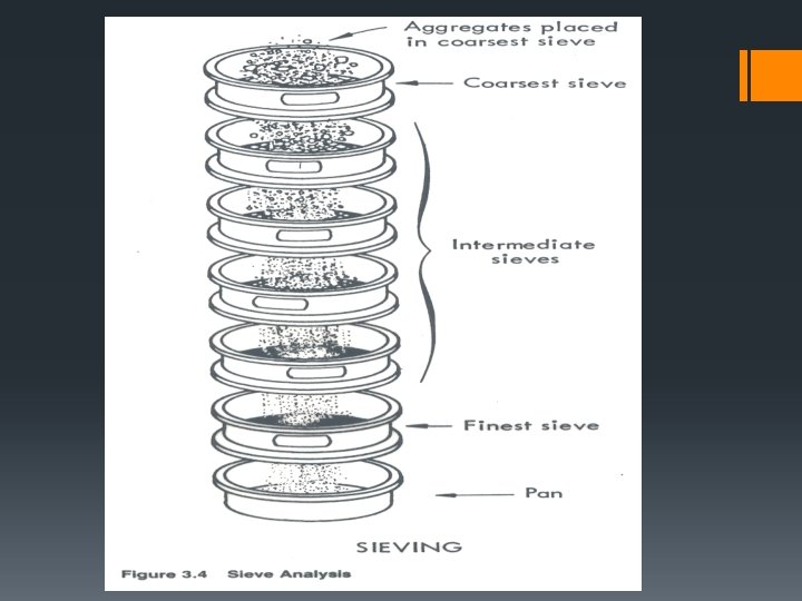
. . cont. soil characteristics § The texture of a soil - mainly on the shapes and sizes of the soil particles and their distribution in the soil mass. § The individual particles of fine-textured soils - invisible to the naked eye, whereas those of coarse textured soils visible to the naked eye. § The distribution of particle size in soils - sieve analysis on a soil sample if the particles are sufficiently large. § For soils containing particle sizes smaller than the lower limit, the hydrometer analysis is used.

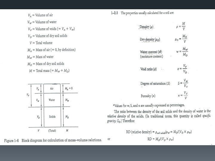
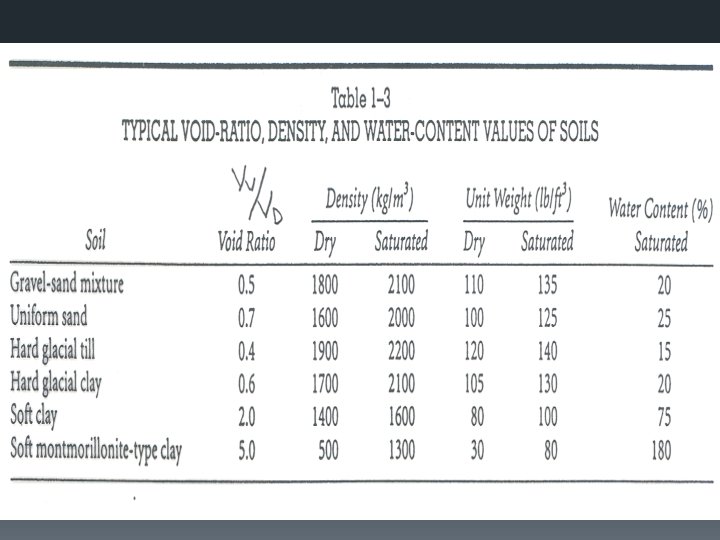
BASIC ENGINEERING PROPERTIES OF SOILS § Influence their behaviour when subjected to external loads. § Three-phase systems that consist of air, water, and solids. § Basic properties; a) Porosity, n b) Void Ratio, e c) Moisture Content, w d) Degree of Saturation, S e) Density of Soil, γ f) Specific Gravity of Soil Particles

. . cont. basic engineering properties § Atterberg limits - water content levels at which the soil changes from one state to the other. § Shrinkage limit (SL), plastic limit (PL), and liquid limit (LL). § Permeability - how water flows through the soil coefficient of permeability (K). § Relationship between the flow velocity and the hydraulic gradient between two points in the soil. § Shear Strength - depends on the cohesion and the angle of internal friction - type of soil. § Triaxial test, the unconfined compression test, or the direct shear test.

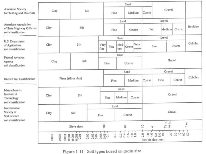
CLASSIFICATION OF SOILS FOR HIGHWAY USE § Systematically categorized according to their probable engineering characteristics. § Identifying suitable subbase materials and predicting the probable behavior of a soil when used as subgrade material. § Most commonly used classification system for highway purposes; AASHTO.

. . cont. classifications of soils AASHTO Soil Classification System § Based on the Public Roads Classification System. § Determining the relative quality of soils for use in embankments, subgrades, subbases, and bases. § Classification of a given soil is based on its particle size distribution, LL, and PI. § Group index (GI) of the soils.
 § Developed during")
. . cont. classifications of soils Unified Soil Classification System (USCS) § Developed during World War II for use in airfield construction. § Modified several times to obtain the current version which also can be applied to other types of construction such as dams and foundations. § The system classifies coarse-grained soils - grain size characteristics and fine-grained soils – plasticity characteristics.

TUTORIAL CLASS 16 April 2018 4 pm – 6 pm Seminar Room Dragon

SOIL SURVEY FOR HIGHWAY CONSTRUCTION § Investigation of the soil characteristics on the highway route and the identification of suitable soils for use as subbase and fill materials. § First step - collection of existing information on the soil characteristics of the area in which the highway is to be located. (geological and agricultural soil maps, existing aerial photographs) § Obtain and investigate enough soil samples along the highway route - identify the boundaries of the different types of soils so that a soil profile can be drawn. (Auger boring or from test pits for laboratory testing)

. . cont. soil survey for highway Geophysical Methods of Soil Exploration § Resistivity and seismic methods. § Resistivity method - the difference in electrical conductivity or resistivity of different types of soils. § An electrical field is produced in the ground by means of two current electrodes and the potential drop between the two intermediate or potential electrodes is then recorded. § Data for the soil profile are obtained by moving the electrode along the center line of the proposed highway.

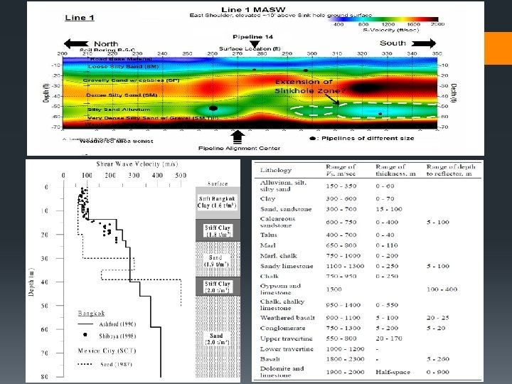
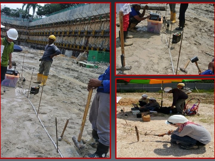
. . cont. soil survey for highway § Seismic method - identify the location of rock profiles or dense strata underlying softer materials. § Inducing impact or shock waves into the soil. (either striking a plate located on the surface with a hammer or exploding small charges in the soil) § Listening devices known as geophones then pick up the shock waves. § The time lapse of the wave traveling to the geophone - calculate the velocity of the wave in the surface soil. § Some of the shock waves can be made to pass from the surface stratum into underlying layers and then back into the surface stratum by moving the shock point away from the geophone.

Resistivity Test

Resistivity Test

Seismic Test

. . cont. seismic tests

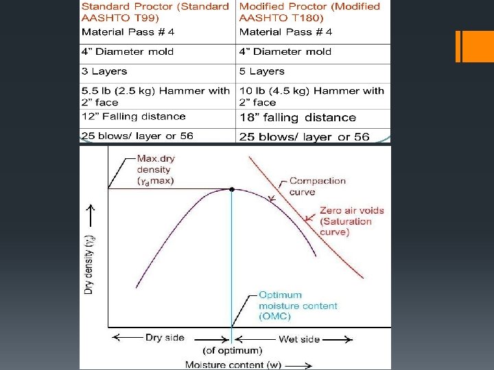
SOIL COMPACTION § Proper compaction of the soil will reduce subsequent settlement and volume change to a minimum - enhancing the strength of the embankment or subbase. § Achieved in the field by using hand-operated tampers, sheeps-foot rollers, rubber-tired rollers, or other types of rollers. § Maximum dry density achieved through compaction. § At low moisture content, the soil particles are not lubricated friction between adjacent particles prevents the densification of the particles.

Basic Theory of Soil Compaction § The process to increase the soil density in order to make use the ground surface for development, ie, building, road, etc. § The volume of void space is reduced by applying high loads over a small area to force the air out of an unsaturated soil mass. § Method of mechanically increasing the density of soil. § If performed improperly, settlement of the soil could occur and result in unnecessary maintenance costs or structure failure. Almost all types of building sites and construction projects utilize mechanical compaction techniques.
 Increases load-bearing capacity")
COMPACTION-WHY COMPACT? There are five principle reasons to compact soil: i) Increases load-bearing capacity ii) Prevents soil settlement and frost damage iii) Provides stability iv) Reduces water seepage, swelling and contraction v) Reduces settling of soil

Compactive Effort
 Spreading the material to the desired layer")
Field Compaction Equipment Two main categories; i) Spreading the material to the desired layer or lift thickness § Spreading equipment - spreading of the material to the required thickness is done by bulldozers and motor graders. ii) Compact each layer of material. § Compacting equipment - rollers are used for field compaction and apply either a vibrating force or an impact force on the soil.

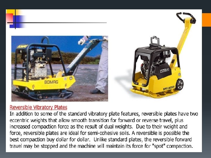
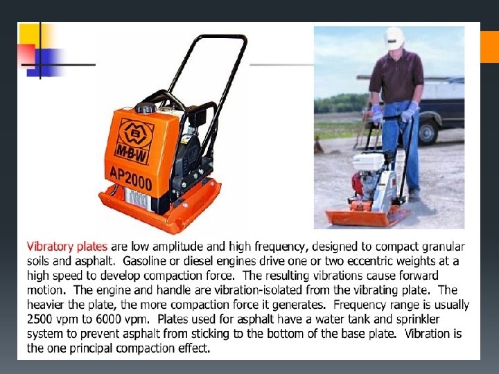
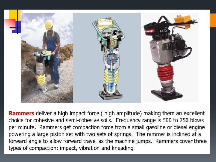
COMPACTION MACHINERIES Granular Soils Sand Clay Cohesive Clay Asphalt x Testing Recommended / x / Testing Recommended X / Testing Recommended / / x Vibratory Rollers X / Testing Recommended / Rammax Rollers Testing Recommended / / x Rammers Vibratory Plates Reversible Plates The equipment used also depend on the size/ area of the project.


https: //www. youtube. com/watch? v=qq 09 Vu. GYE 1 E
 TEST § Special soil tests that are sometimes undertaken to")
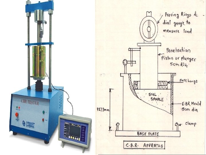
CALIFORNIA BEARING RATIO (CBR) TEST § Special soil tests that are sometimes undertaken to determine the strength or supporting value of a given soil. § Determination of the load-deformation curve of the soil standard CBR testing equipment. § Samples of soil compacted to required standards - immersed in water four days - samples are loaded with a surcharge that simulate the estimated weight of pavement material the soil will support. § Determine the relative strength of a soil with respect to crushed rock. § It does not correctly simulate the shearing forces imposed on sub-base and subgrade materials as they support highway pavements.


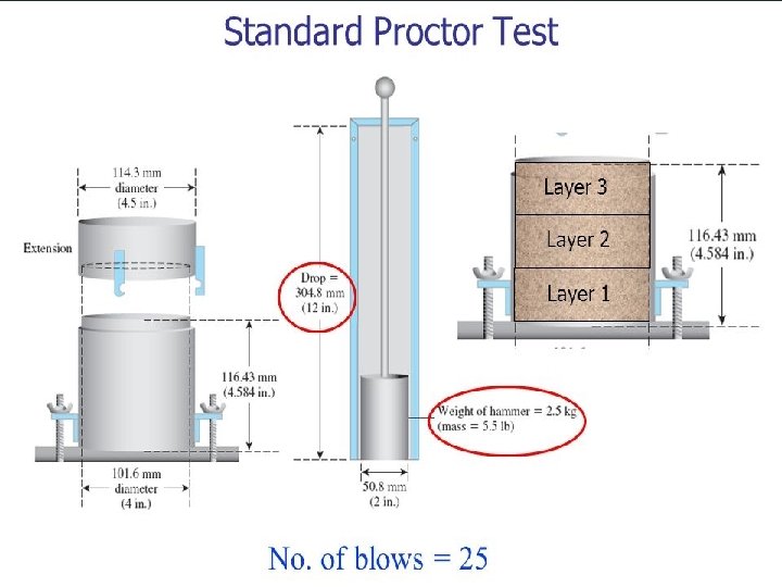
EXAMPLE 1 § The table shows results obtained from a standard AASHTO compaction test on six samples, 4 in. diameter, of a soil to be used as fill for a highway. Calculate the maximum dry density and the optimum moisture content of the soil. Given volume of mould = 944 cm 3 and mass of mould+base = 2. 3 kg. Sample No Weight of Compacted Soils (kg) Moisture Content (%) 1 1. 89 4. 0 2 1. 99 6. 1 3 2. 09 7. 8 4 2. 12 10. 1 5 2. 07 12. 1 6 2. 03 14. 0

EXAMPLE 2
 0.")
EXAMPLE 3 Determine the CBR value based on data given below; Penetration (mm) 0. 0 0. 5 1. 0 1. 5 2. 0 2. 5 3. 0 3. 5 4. 0 4. 5 5. 0 Sample 1 0 0. 32 0. 5 0. 67 0. 81 0. 92 1. 02 1. 11 1. 22 1. 29 1. 34 Load (k. N) Sample 2 0 0. 3 0. 45 0. 63 0. 77 0. 91 1. 06 1. 2 1. 32 1. 45 1. 54 Sample 3 0 0. 2 0. 42 0. 65 0. 84 1. 01 1. 13 1. 24 1. 32 1. 38 1. 45
 1. 2 1 0. 8 0.")
SOLUTION 1. 6 1. 4 Load (k. N) 1. 2 1 0. 8 0. 6 0. 4 0. 2 0 0. 0 1. 0 2. 0 3. 0 4. 0 Penetration (mm) 5. 0 6. 0

- Slides: 50