Chapter 5 Atmospheric Pressure and Wind Atmospheric Pressure


 Average pressure at sea")

 Air descends Moves divergently near the surface")
 Rising air Moves convergently (together) from the")
 w/ Friction")


 due to")

 • Starts when abnormally warm water appears off the western")

- Slides: 20
Chapter 5 Atmospheric Pressure and Wind
Atmospheric Pressure Atmospheric pressure – force exerted by the weight of atmospheric gas molecules At sea level, pressure is generally 14. 7 psi Decreases with increasing altitude Due to gas molecules being less concentrated; less “stacked” upon each other Less air density = less pressure; more air density = higher pressure The “Ideal Gas Law” Pressure will increase if density stays constant but temperature increases Pressure will increase if temperature stays constant but density increases
Vertical Pressure Profile
Relationship between Pressure and Temperature Increases in temperature result in an increase in air pressure and vice versa Dynamic influences on air pressure: Dynamic high – strongly descending air associated with high pressure at the surface Thermal high – very cold surface conditions associated with high pressure at the earth's surface Dynamic low – strongly rising air associated with low pressure at the surface Thermal low – very warm surface conditions often associated with relatively low pressure at the earth's surface
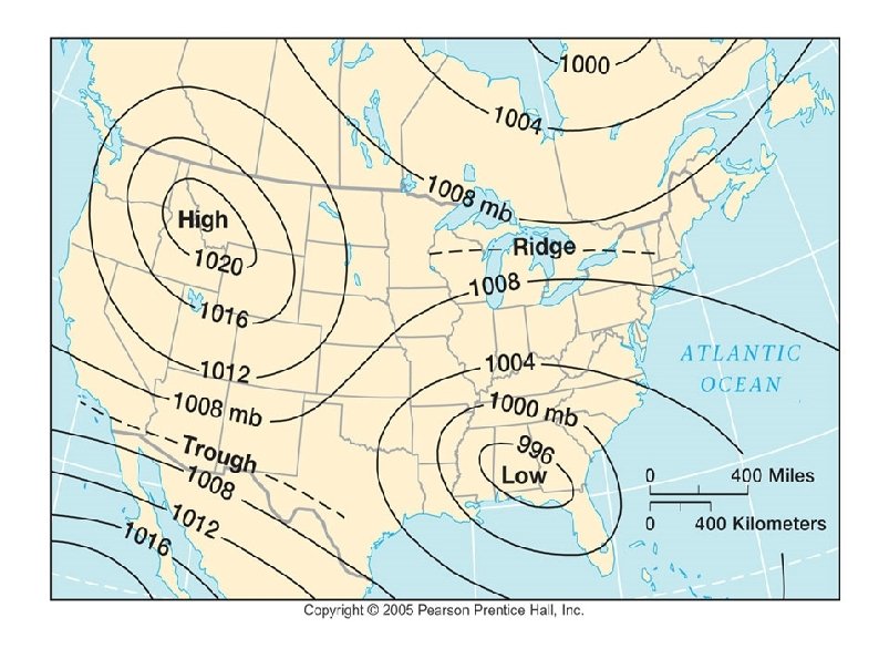
Measuring Air Pressure Air pressure is measured in millibars (mb) Average pressure at sea level is 1013. 5 mb Mapped using isobars (fig. 5 -4) Ridges – elongated areas of relatively high pressure Troughs – areas of low pressure Pressure gradient – the slope of pressure changes across isobars Pressure differences exist due to unequal heating of the earth's surface
Wind is air moving from an area of high atmospheric pressure to an area of low atmospheric pressure. Wind Explanation - Influences on wind direction • Pressure gradient • The Coriolis Effect – – • Causes deflection of wind Geostrophic wind – air that moves parallel to isobars Friction – Slows wind speed *Winds are named for their direction of origin
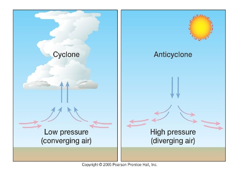
High Pressure Systems Anti-cyclones (high pressure center) Air descends Moves divergently near the surface (outward from center) Flows clockwise in the Northern Hemisphere Usually associated with clear skies and calm weather
Low Pressure Systems Cyclones (low pressure centers) Rising air Moves convergently (together) from the surface toward the pressure center Flows counter-clockwise in the Northern Hemisphere Generally associated with cloudy skies
Pressure Gradient + Coriolis + Friction Forces w/out Friction (gradient wind) w/ Friction
Global Circulation Patterns
Major Global Circulation Components Hadley Cells – vertical convective circulation cells situated near the equator; air subsides into the subtropical highs Intertropical Convergence Zone (ITCZ) – zone near the equator where the trade winds converge to form the Hadley Cells; associated with frequent thunderstorms Trade Winds – easterly winds of the tropics that diverge toward the west and equator Subtropical Highs – large, semipermanent high-pressure cells situated at about 30 degrees N & S Westerlies – major wind system of the midlatitudes that flow from west to east; found between 30 & 60 degrees N & S Subpolar Lows – semipermanent low pressure cells situated at about 50 to 60 degrees N & S Polar Easterlies – easterly winds that are typically cold and dry Polar Highs – high pressure cells situated above the poles
Jet Streams Zones of strong winds in the upper troposphere Flow in a westerly direction Speed is variable A minimum speed of 60 knots is required for recognition of a jet stream 2 per hemisphere Polar & subtropical
Monsoons are a season reversal of winds - onshore flow: sea-to-land movement - occurs during summer - heavy summer rains - offshore flow: land-to-sea movement - occurs during winter - a pronounced winter dry season “Arizona Monsoon” - onshore winds in summer carry moisture from the Sea of Cortez & the Gulf of Mexico into the Southwestern U. S. - result is bursts of thunderstorm activity
Localized Wind Systems • Sea Breezes • wind blowing from sea-to-land; usually during daytime • Land Breezes • wind flowing from land-to-water; usually during night *Like other winds, breeze names tell the direction/location from which they originate
• Valley Breezes • wind that blows up a mountainside (upslope) due to the heating of air on the mountain’s slope during the day • Mountain Breezes • The downslope wind from a mountain as a result of the cooling of air on its slopes at night Valley Breeze Mountain Breeze
Santa Ana Winds • Develop when a cell of high pressure sits over the interior Western United States for several days. • Brings warm northerly or easterly winds to the coast • Reversal of wind flowing from sea-to-land • High speed wind • High temperature • Extremely dry *all of these conditions contribute to wild/brush fires throughout Southern California in late summer & fall
El-Nino Southern Oscillation (ENSO) • Starts when abnormally warm water appears off the western coast of South America. • Happens every 3 to 7 years • Heavy rain in areas that normally don’t experience such conditions • Droughts in other areas • Southern Oscillation - Trade Winds in Southern Hemisphere reverse direction, resulting in warm currents flowing toward South American’s west coast (fig. 5 -38) • • Months before the onset of El Nino, Trade Winds pile up warm water in the Western Pacific near Indonesia La Nina – the opposite of El Nino • Less rain in Southern California
El Nino – La Nina comparison Understanding Enso