Chapter 3 Communities Biomes and Ecosystems Section 1


Chapter 3 Communities, Biomes, and Ecosystems Section 1: Community Ecology Section 2: Terrestrial Biomes Section 3: Aquatic Ecosystems Click on a lesson name to select.

Chapter 3 Communities, Biomes, and Ecosystems 3. 2 Terrestrial Biomes Tundra § Average precipitation: 15– 25 cm per year § Temperature range: -34°C– 12°C § Geographic location: South of the polar ice caps in the Northern Hemisphere § Abiotic factors: soggy summers; permafrost; cold and dark much of the year

Chapter 3 Communities, Biomes, and Ecosystems 3. 2 Terrestrial Biomes Boreal Forest § Average precipitation: 30– 84 cm per year § Temperature range: -54°C– 21°C § Geographic location: northern part of North America, Europe, and Asia § Abiotic factors: summers are short and moist; winters are long, cold, and dry

Chapter 3 Communities, Biomes, and Ecosystems 3. 2 Terrestrial Biomes Temperate Forest § Average precipitation: 75– 150 cm per year § Temperature range: -30°C– 30°C § Geographic location: south of the boreal forests in eastern North America, eastern Asia, Australia, and Europe § Abiotic factors: well-defined seasons; summers are hot, winters are cold

Chapter 3 Communities, Biomes, and Ecosystems 3. 2 Terrestrial Biomes Temperate Woodland Shrubland § Average precipitation: 38– 100 cm per year § Temperature range: 10°C– 40°C § Geographic location: surrounds the Mediterranean Sea, western coast of North and South America, South Africa, and Australia § Abiotic factors: summers are very hot and dry; winters are cool and wet

Chapter 3 Communities, Biomes, and Ecosystems 3. 2 Terrestrial Biomes Temperate Grassland § Average precipitation: 50– 89 cm per year § Temperature range: -40°C– 38°C § Geographic location: North America, South America, Asia, Africa, and Australia § Abiotic factors: summers are hot; winters are cold; moderate rainfall; fires possible

• Planet Earth – Great Plains

Chapter 3 Communities, Biomes, and Ecosystems 3. 2 Terrestrial Biomes Desert § Average precipitation: 2 – 26 cm per year § Temperature range: high: 20°C– 49°C; low: -18°C– 10°C § Geographic location: every continent except Europe § Abiotic factors: varying temperatures; low rainfall

Chapter 3 Communities, Biomes, and Ecosystems 3. 2 Terrestrial Biomes Tropical Savanna § Average precipitation: 50 – 130 cm per year § Temperature range: 20°C– 30°C § Geographic location: Africa, South America, and Australia § Abiotic factors: summers are hot and rainy; winters are cool and dry

Chapter 3 Communities, Biomes, and Ecosystems 3. 2 Terrestrial Biomes Tropical Seasonal Forest § Average precipitation: >200 cm per year § Temperature range: 20°C– 25°C § Geographic location: Africa, Asia, Australia, and South and Central America § Abiotic factors: rainfall is seasonal

Chapter 3 Communities, Biomes, and Ecosystems 3. 2 Terrestrial Biomes Tropical Rain Forest § Average precipitation: 200– 1000 cm per year § Temperature range: 24°C – 27°C § Geographic location: Central and South America, southern Asia, western Africa, and northeastern Australia § Abiotic factors: humid all year; hot and wet

Chapter 3 Communities, Biomes, and Ecosystems 3. 2 Terrestrial Biomes Mountains § If you go up a mountain, you might notice that abiotic conditions, such as temperature and precipitation, change with increasing elevation.

Chapter 3 Communities, Biomes, and Ecosystems 3. 2 Terrestrial Biomes Polar Regions § Border the tundra at high latitudes § Polar regions are cold all year. Penguins in Antarctica

• March of the Penguins

• Fresh Water BBC world

Chapter 3 Communities, Biomes, and Ecosystems 3. 3 Aquatic Ecosystems Freshwater Ecosystems § Only about 2. 5 percent of the water on Earth is freshwater.

Chapter 3 Communities, Biomes, and Ecosystems 3. 3 Aquatic Ecosystems Rivers and Streams § The characteristics of rivers and streams change during the journey from the source to the mouth.

Chapter 3 Communities, Biomes, and Ecosystems 3. 3 Aquatic Ecosystems § Fast-moving rivers and streams prevent much accumulation of organic materials and sediment. § Usually, there are fewer species living in the rapid waters. § In slow-moving water, insect larvae are the primary food source for many fish, including American eel, brown bullhead catfish, and trout.

Chapter 3 Communities, Biomes, and Ecosystems 3. 3 Aquatic Ecosystems Lakes and Ponds § The temperature of lakes and ponds varies depending on the season.

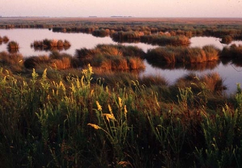
Chapter 3 Communities, Biomes, and Ecosystems 3. 3 Aquatic Ecosystems Transitional Aquatic Ecosystems § Areas of land such as marshes, swamps, and bogs that are saturated with water and that support aquatic plants are called wetlands. Bog

Chapter 3 Communities, Biomes, and Ecosystems 3. 3 Aquatic Ecosystems Marine Ecosystems § The intertidal zone is a narrow band where the ocean meets land. § Communities are constantly changing in this environment as a result of disturbance.

Mississippi River Floods and Wetlands • How is this a study in Ecology? • The ‘Web of Interdependence’ describes that – the first ecological truth regards that our planet is home not only to humans but to many other forms of life as well! – Second, the health of human society depends on the well-being of much of that life!

What is a Marsh? A levee? A marsh is…… • Low lying wetland w/ grassy vegetation – Transition zone between land water A Levee is… • Type of dam that runs along the banks of a river or canal to prevent flooding

Delta Marshes • Mississippi River Delta Image taken 5/24/2001 by ASTER • Turbid waters spill out into the Gulf of Mexico where their suspended sediment is deposited to form the Mississippi River Delta. • Like the webbing on a duck's foot, marshes and mudflats prevail between the shipping channels that have been cut into the delta.


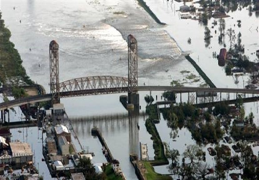
Levees and their effects to marshes • In New Orleans, the systematic construction of levees began in the 19 th century. The current levee system dates to the 1960 s. The US Army Corps of Engineers designed the levees to withstand the forces of a fast-blowing "Category 3" storm. • Work on the levees was not completed; they weren't strong enough to survive the "Category 4" Hurricane Katrina. In August 2005, several levees along waterways of Lake Ponchartrain failed. Water covered 80% of New Orleans.
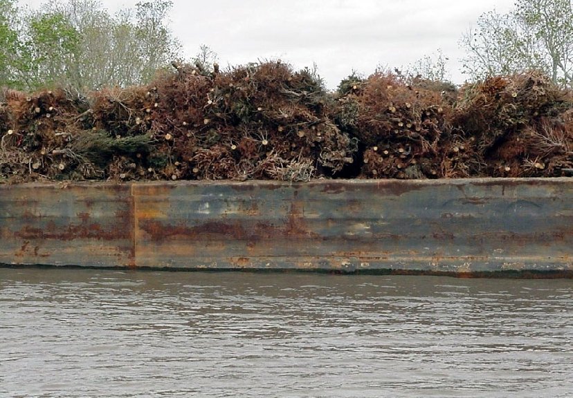

Information on Cypress Trees in Swamps taken from National Public Radio • Once a century, cypress trees grow large enough to harvest for furniture, shingles etc. – (75 -100 ft tall!) • Ecology professor Gary Shaffer says cypress play a crucial role in the swamp forests that cover hundreds of thousands of acres of coastal Louisiana. • These swamps prevent floods by collecting storm waters and clean water by filtering out pollution. They also provide habitat for a wide variety of animals, such as migratory songbirds (the ivory-billed woodpecker, until recently believed extinct, once thrived in the swamps).

• Hurricane on the Bayou
- Slides: 32