
Chapter 2 SaltTectonics Provinces and Superposed Deformation Across


- Slides: 80
Chapter 2 Salt-Tectonics Provinces and Superposed Deformation Across the Continental-Oceanic Boundary in Offshore Angola M. P. A. Jackson (University of Texas) AGL - Total. Fina - 1998 J. -M. Fonck (Total. Fina) C. Cramez (Total. Fina)
Summary The Angolan margin is the type area for raft tectonics. New seismic data reveal the contractional buffer for this thin-skinned extension. A composite section from the Lower Congo Basin and Kwanza Basin illustrates a complex history of superposed deformation caused by (1) progradation of the margin and (2) episodic Tertiary epeirogenic uplift. Late Cretaceous tectonics was driven by a gentle slope created by thermal subsidence; extensional rafting took place updip, contractional thrusting and buckling downdip; some distal folds were possibly unroofed to form massive salt walls. Oligocene deformation was triggered by kinking of the Atlantic Hinge Zone as the shelf and coastal plain rose by 2 or 3 km; that stripped Paleogene cover off the shelf, provided space for Miocene progradation, and steepened the continental slope, triggering more extension and buckling. In the Neogene, a subsalt half graben was inverted, creating keystone faults that may have controlled the Congo Canyon; a thrust duplex of seaward-displaced salt jacked up the former abyssal plain, creating a plateau of salt 3– 4 km thick on the present lower slope. The Angola Escarpment may be the toe of the Angola thrust nappe, in which a largely Cretaceous roof of gently buckled strata was possibly transported above the salt duplex by up to ~20 km. AGL - Total. Fina - 1998 2
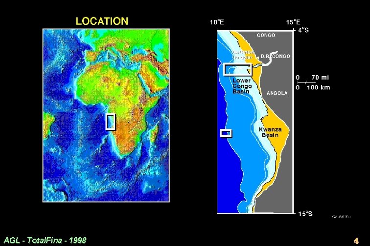
Introduction · West African margin in the South Atlantic has yielded prolific hydrocarbons, especially in the area around Cabinda, comprising northern Angola, Congo, and Democratic Republic of Congo (DRC) (Slide 17. 2. 4). · Region forms part of the Lower Congo Basin. This basin overlies rifted crust originally contiguous with that below the Campos Basin of Brazil before separation in the Early Cretaceous. · Current exploration boom along the Angolan margin focuses on the deeper regions. AGL - Total. Fina - 1998 3
AGL - Total. Fina - 1998 4
Tectonic Setting · New seismic data reveal salt provinces comprising a spectacular mixture of fold belts and allochthonous salt canopies. · Outboard of this divergent margin forms one of the best examples of contractional salt tectonics in the world. · Extensional inboard regions of this margin are the type area for raft tectonics (Duval et al. , 1992; Lundin, 1992; Spathopoulos, 1996). · The area includes the large, active Congo Fan, which is part of the greatest postsalt depocenter along the West African margin south of the Niger Delta. AGL - Total. Fina - 1998 5
Scope of Chapter · This chapter is a reconnaissance survey of some features of salt tectonics across the continental-oceanic boundary. · The Aptian salt obscures this boundary, so its precise position is unknown. · We speculate on the causes and timing of salt tectonics and propose a history of superposed deformation that is more varied and complex than previously thought. · We focus on an area near the Congo Canyon, the submarine extension of the Congo estuary separating the DRC from Angola (Slide 17. 2. 4). · Despite an overburden up to 6 km thick, new seismic data reveal deep salt structures remarkably clearly. Seismic data from Western Geophysical, supplied by Total. Fina. · Using a composite section (Slide 17. 2. 8) for navigation, a seaward traverse focuses on geometric relationships that elucidate the causes and timing of deformation. We then synthesize the deformation history. AGL - Total. Fina - 1998 6
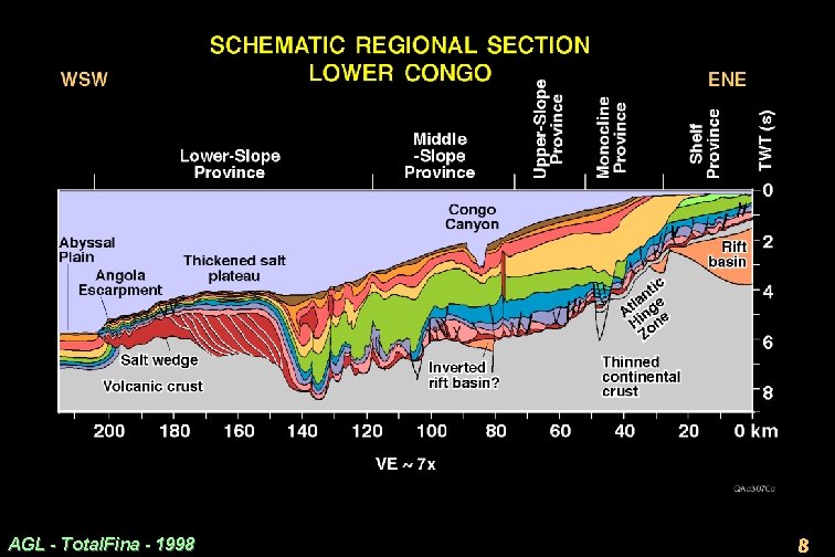
Schematic Regional Section: Bathymetric Provinces · The regional cross section splices several time-migrated seismic lines (Slide 17. 2. 8). · Vertical exaggeration is about 7× (assuming average overburden sonic velocities of 2200 m/s). · The western segment of this composite line is from an area about 300 km south in the Kwanza Basin (Slide 17. 2. 4). · The structures in the composite line depict our seismic interpretation, but their juxtaposition is schematic because the locations are composite. · 3 main bathymetric features (Slide 17. 2. 8): (1) Truncated shelf uplifted in the mid-Tertiary and Neogene. (2) Uniform slope interrupted by 800 -m-deep Congo Canyon. (3) Elevated, flat-topped salt plateau forming a toe-thrust complex. AGL - Total. Fina - 1998 7
AGL - Total. Fina - 1998 8
Schematic Regional Section: Salt-Tectonic Provinces · Middle to upper Aptian evaporites are shown in red (Slide 17. 2. 8). · Progressing seaward, the main salt-tectonic features are as follows. – Thin salt, extensional rafts and turtles form the Shelf, Monocline, and Upper Slope Provinces. – Thin salt and mostly contractional structures form the Middle-Slope Province. – Originally thick salt deformed into rejuvenated salt walls and a toe-thrust complex cored by tectonically thickened salt define the Lower Slope Province. AGL - Total. Fina - 1998 9
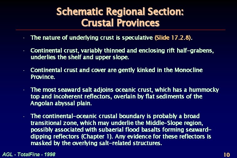
Schematic Regional Section: Crustal Provinces · The nature of underlying crust is speculative (Slide 17. 2. 8). · Continental crust, variably thinned and enclosing rift half-grabens, underlies the shelf and upper slope. · Continental crust and cover are gently kinked in the Monocline Province. · The most seaward salt adjoins oceanic crust, which has a hummocky top and incoherent reflectors, overlain by flat sediments of the Angolan abyssal plain. · The continental-oceanic crustal boundary is probably a broad transitional zone, which may underlie the Middle-Slope region, possibly associated with subaerial flood basalts forming seawarddipping reflectors (Chapter 1). Any evidence for these reflectors is masked by the overlying salt-related structures. AGL - Total. Fina - 1998 10
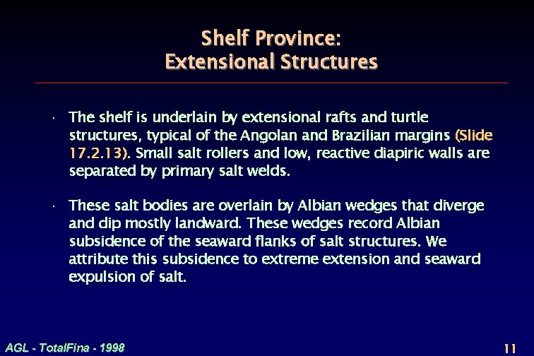
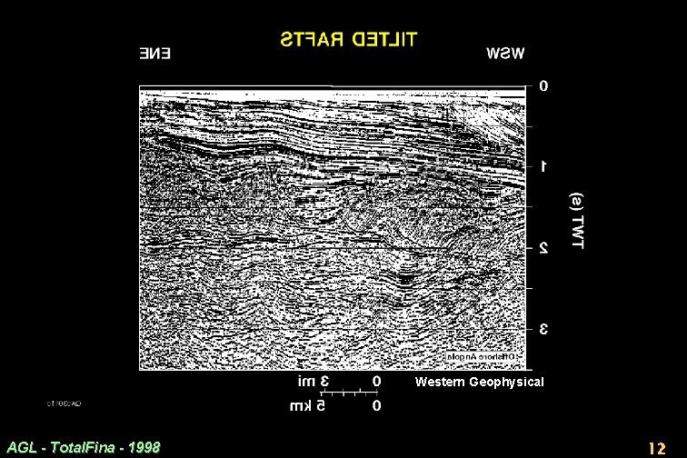
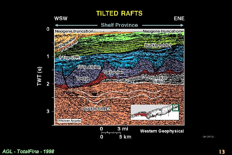
Shelf Province: Extensional Structures · The shelf is underlain by extensional rafts and turtle structures, typical of the Angolan and Brazilian margins (Slide 17. 2. 13). Small salt rollers and low, reactive diapiric walls are separated by primary salt welds. · These salt bodies are overlain by Albian wedges that diverge and dip mostly landward. These wedges record Albian subsidence of the seaward flanks of salt structures. We attribute this subsidence to extreme extension and seaward expulsion of salt. AGL - Total. Fina - 1998 11
Western Geophysical AGL - Total. Fina - 1998 12
Western Geophysical AGL - Total. Fina - 1998 13
Shelf Province: Contractional Structures Above Salt · Gentle folds overlie the rafted interval (Slide 17. 2. 13). Some folds typify extensionally driven subsidence; e. g. , rollover folds associated with listric faults. · Other folds indicate subtle contraction in the Tertiary: parallel reflectors of Paleogene strata are gently folded between 1 and 2 s TWT. · Lack of visible faults at this stratigraphic level indicates that this subtle folding is probably not caused by extension. · Drape compaction seems implausible because these folds are absent over similar extensional structures elsewhere in the section. · This evidence for subtle contraction is present in shallow strata on the shelf. Thus, contraction need not be confined to either great water depths or great burial depths. These buckle folds may be related to the same tectonic event that caused the Neogene truncation at the overlying sea floor. AGL - Total. Fina - 1998 14
Shelf Province: Contractional Structures Below Salt · Gentle, rounded folds also underlie the salt (Slide 17. 2. 13). · Thick isopachous strata are folded in the rift basin. · This style suggests buckling because there is no visible relationship to rift faults or to velocity effects. · Buckling may predate the salt, but this is uncertain. · In later slides (Slides 17. 2. 41 -42), we discuss possible effects of Tertiary inversion below the salt underneath the Congo Canyon. AGL - Total. Fina - 1998 15
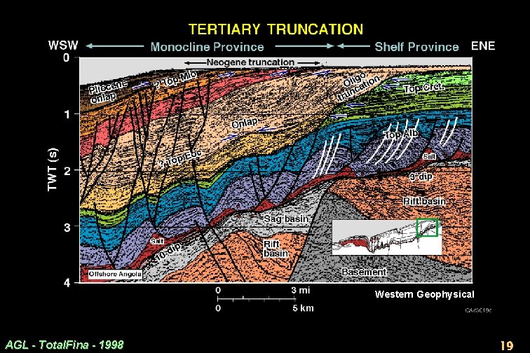
Monocline Province: Overview · The Monocline Province is defined by a gentle kink where the base of salt steepens (Slide 17. 2. 8). · The Monocline Province is generally known as the Atlantic Hinge Zone, which was called the “Atlantic hinge line” where it was originally recognized in Gabon by Brink (1974). We use the term “Monocline Province” to include smaller hinge zones as well. · The base of salt steepens from ~3 dip in the Shelf Province, to ~10 in the monocline, to ~6 in the Upper-Slope Province. · Farther seaward, the base of salt is poorly imaged, so its dip is uncertain. But seaward of the Lower Congo depocenter, the dip probably reverses and slopes landward. · Across the Monocline Province, the base of salt (and base of Tertiary) is vertically offset by about 3 s TWT, equivalent to between 3 and 4 km. AGL - Total. Fina - 1998 16
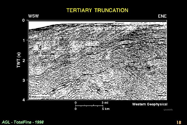
Monocline Province: Oligocene Truncation · 2 major truncations cut the outer shelf above the Monocline Province · These are Oligocene and Neogene in age (Slides 17. 2. 19 -23). · Miocene strata onlap the deeper truncation, marking the middle to late Oligocene erosional hiatus. · The Oligocene truncation surface was cut by as much as 30 km landward erosion and 600 to 2000 m of vertical truncation of the Upper Cretaceous and Paleogene carbonate platform (Lavier et al. , 1995; Steckler et al. , 1997, Congo; Karner et al. 1997, Gabon). AGL - Total. Fina - 1998 17
Western Geophysical AGL - Total. Fina - 1998 18
Western Geophysical AGL - Total. Fina - 1998 19
Monocline Province: Oligocene Uplift · The truncation coincides with a eustatic fall in relative sea level of >300 m at about 30 Ma. But that fall is much less than the estimated depth of truncation. · Thermal subsidence after Neocomian continental breakup would have been largely complete by the Oligocene. · Thus, formation of the Monocline Province must be caused largely by epeirogenic uplift of the shelf. · The cause of this uplift is highly speculative but could have been an initial thermal bulge above the Cameroon hotspot, which subsequently emplaced the Cameroon Volcanic Line in the Miocene (Meyers et al. , 1996). Fluidinclusion temperatures in offshore Angola indicate that a thermal pulse in the Miocene raised temperatures by 30°– 40°C and the geotherm to 50– 60°C/km (Walgenwitz, 1990). Temperatures increased northward toward the Cameroon hotspot. AGL - Total. Fina - 1998 20
Monocline Province: Neogene Truncation · A shallow truncation bevels the youngest strata on the outer shelf. · Across a width of at least 15 km on the shelf, Upper Cretaceous and Paleogene isopachous strata have been truncated at the sea floor (Slide 17. 2. 13, 19). · Farther west at the present shelf break, a zone at least 8 km wide contains Neogene foresets that end abruptly at the sea floor (Slide 17. 2. 19). This geometry suggests an origin by truncation rather than toplap. AGL - Total. Fina - 1998 21
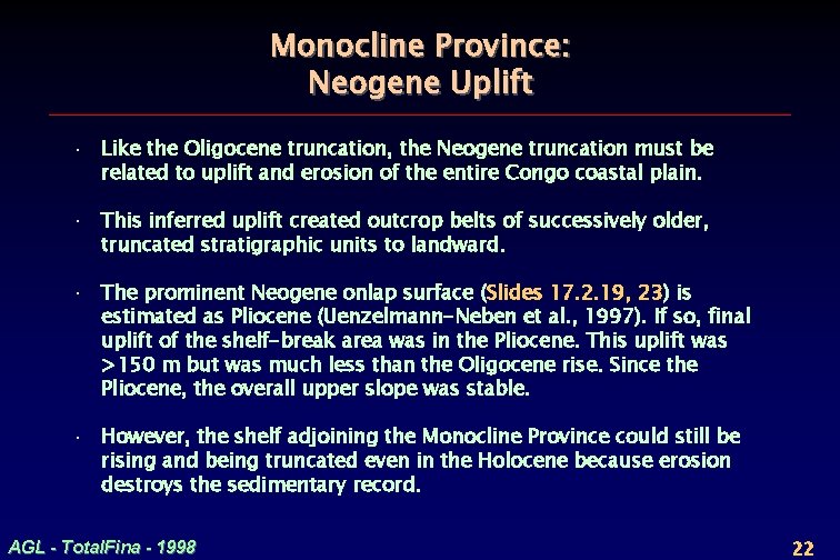
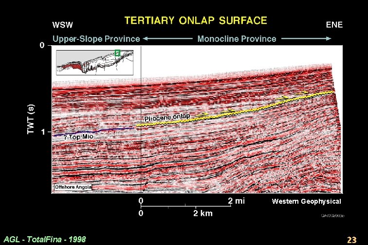
Monocline Province: Neogene Uplift · Like the Oligocene truncation, the Neogene truncation must be related to uplift and erosion of the entire Congo coastal plain. · This inferred uplift created outcrop belts of successively older, truncated stratigraphic units to landward. · The prominent Neogene onlap surface (Slides 17. 2. 19, 23) is estimated as Pliocene (Uenzelmann-Neben et al. , 1997). If so, final uplift of the shelf-break area was in the Pliocene. This uplift was >150 m but was much less than the Oligocene rise. Since the Pliocene, the overall upper slope was stable. · However, the shelf adjoining the Monocline Province could still be rising and being truncated even in the Holocene because erosion destroys the sedimentary record. AGL - Total. Fina - 1998 22
Western Geophysical AGL - Total. Fina - 1998 23
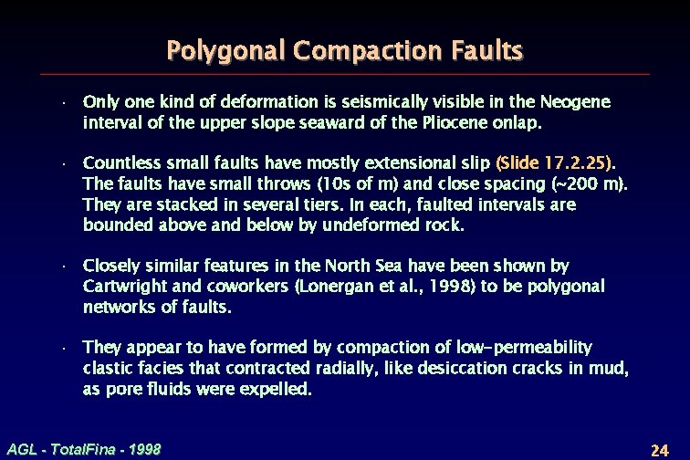
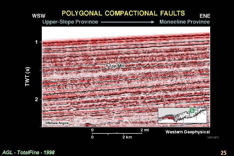
Polygonal Compaction Faults · Only one kind of deformation is seismically visible in the Neogene interval of the upper slope seaward of the Pliocene onlap. · Countless small faults have mostly extensional slip (Slide 17. 2. 25). The faults have small throws (10 s of m) and close spacing (~200 m). They are stacked in several tiers. In each, faulted intervals are bounded above and below by undeformed rock. · Closely similar features in the North Sea have been shown by Cartwright and coworkers (Lonergan et al. , 1998) to be polygonal networks of faults. · They appear to have formed by compaction of low-permeability clastic facies that contracted radially, like desiccation cracks in mud, as pore fluids were expelled. AGL - Total. Fina - 1998 24
Western Geophysical AGL - Total. Fina - 1998 25
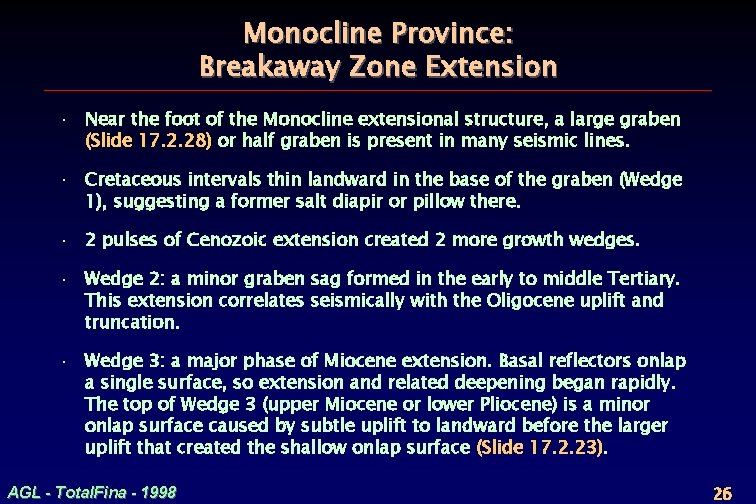
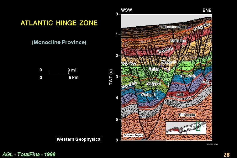
Monocline Province: Breakaway Zone Extension · Near the foot of the Monocline extensional structure, a large graben (Slide 17. 2. 28) or half graben is present in many seismic lines. · Cretaceous intervals thin landward in the base of the graben (Wedge 1), suggesting a former salt diapir or pillow there. · 2 pulses of Cenozoic extension created 2 more growth wedges. · Wedge 2: a minor graben sag formed in the early to middle Tertiary. This extension correlates seismically with the Oligocene uplift and truncation. · Wedge 3: a major phase of Miocene extension. Basal reflectors onlap a single surface, so extension and related deepening began rapidly. The top of Wedge 3 (upper Miocene or lower Pliocene) is a minor onlap surface caused by subtle uplift to landward before the larger uplift that created the shallow onlap surface (Slide 17. 2. 23). AGL - Total. Fina - 1998 26
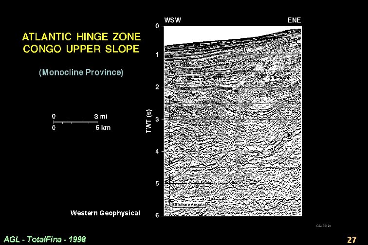
Western Geophysical AGL - Total. Fina - 1998 27
Western Geophysical AGL - Total. Fina - 1998 28
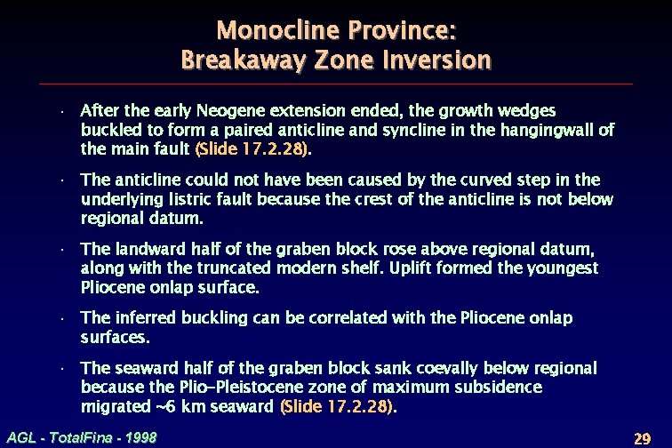
Monocline Province: Breakaway Zone Inversion · After the early Neogene extension ended, the growth wedges buckled to form a paired anticline and syncline in the hangingwall of the main fault (Slide 17. 2. 28). · The anticline could not have been caused by the curved step in the underlying listric fault because the crest of the anticline is not below regional datum. · The landward half of the graben block rose above regional datum, along with the truncated modern shelf. Uplift formed the youngest Pliocene onlap surface. · The inferred buckling can be correlated with the Pliocene onlap surfaces. · The seaward half of the graben block sank coevally below regional because the Plio-Pleistocene zone of maximum subsidence migrated ~6 km seaward (Slide 17. 2. 28). AGL - Total. Fina - 1998 29
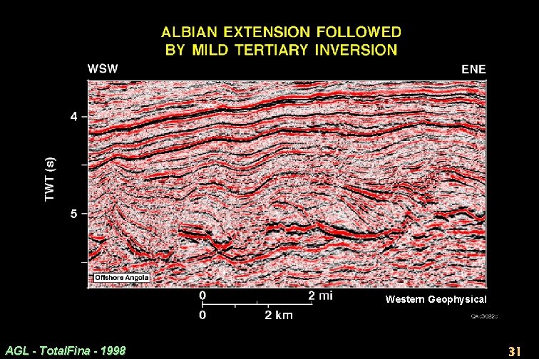
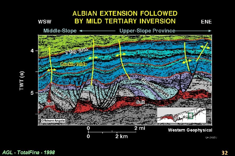
Upper-Slope Province: Mid-Cretaceous Extension · The Upper Slope Province is seaward of the Monocline Province (Slide 17. 2. 8). · It features mostly extensional salt tectonics above a gently dipping base of salt (Slide 17. 2. 32). · Upper Albian growth wedges thicken landward and trail behind small tilted rafts of lower Albian carbonates resting on small salt rollers. · This geometry indicates extreme extension soon after salt deposition, a style of raft tectonics that has been illustrated often from the Angolan margin. · Of significance are clear signs for Late Cretaceous and Eocene shortening, which is more prominent than on the shelf (Slide 17. 2. 13). AGL - Total. Fina - 1998 30
Western Geophysical AGL - Total. Fina - 1998 31
Western Geophysical AGL - Total. Fina - 1998 32
Upper-Slope Province: Late-Cretaceous Contraction · On the extreme left of Slide 17. 2. 32, an Albian raft is steeply tilted landward. Its crest is above regional datum. It adjoins a narrow diapir that appears to be pinched. · Apart from the raft’s steepness and height, it resembles the other rafts. · We infer that this is an originally extensional raft, later rotated by compression. · Thinning and onlap onto its crest record shortening after the extension shown by rafts on the right. · This steepened raft marks the landward edge of the main contractional zone that absorbed some of the extensional rafting. This point thus marks the landward edge of the next structural province. AGL - Total. Fina - 1998 33
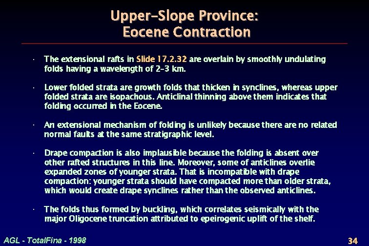
Upper-Slope Province: Eocene Contraction · The extensional rafts in Slide 17. 2. 32 are overlain by smoothly undulating folds having a wavelength of 2– 3 km. · Lower folded strata are growth folds that thicken in synclines, whereas upper folded strata are isopachous. Anticlinal thinning above them indicates that folding occurred in the Eocene. · An extensional mechanism of folding is unlikely because there are no related normal faults at the same stratigraphic level. · Drape compaction is also implausible because the folding is absent over other rafted structures in this line. Moreover, some of anticlines overlie expanded zones of younger strata. That is incompatible with drape compaction: younger strata should have compacted more than older strata, which would create drape synclines rather than the observed anticlines. · The folds thus formed by buckling, which correlates seismically with the major Oligocene truncation attributed to epeirogenic uplift of the shelf. AGL - Total. Fina - 1998 34
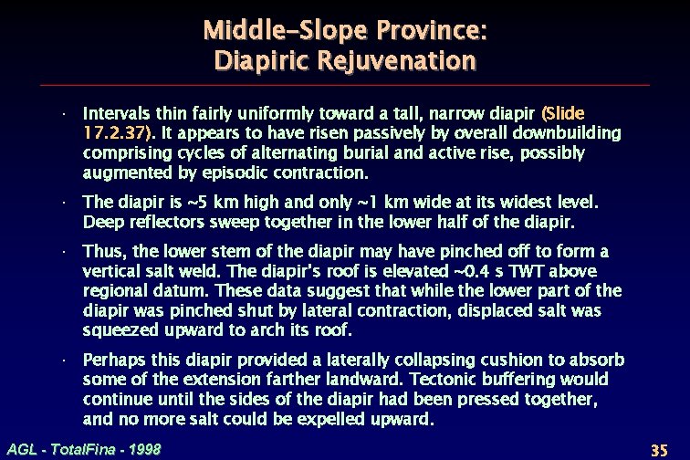
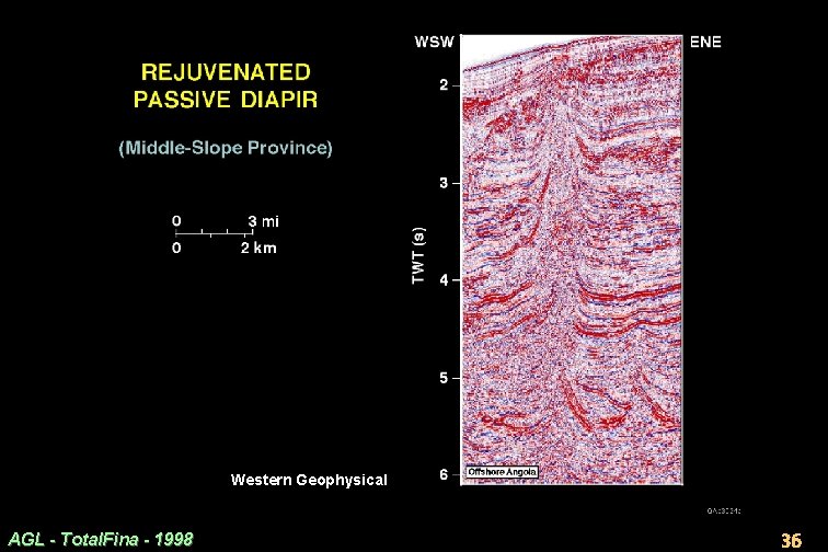
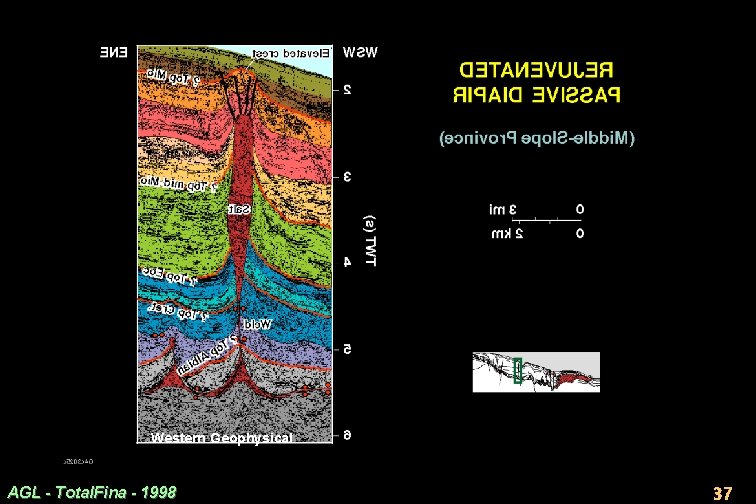
Middle-Slope Province: Diapiric Rejuvenation · Intervals thin fairly uniformly toward a tall, narrow diapir (Slide 17. 2. 37). It appears to have risen passively by overall downbuilding comprising cycles of alternating burial and active rise, possibly augmented by episodic contraction. · The diapir is ~5 km high and only ~1 km wide at its widest level. Deep reflectors sweep together in the lower half of the diapir. · Thus, the lower stem of the diapir may have pinched off to form a vertical salt weld. The diapir’s roof is elevated ~0. 4 s TWT above regional datum. These data suggest that while the lower part of the diapir was pinched shut by lateral contraction, displaced salt was squeezed upward to arch its roof. · Perhaps this diapir provided a laterally collapsing cushion to absorb some of the extension farther landward. Tectonic buffering would continue until the sides of the diapir had been pressed together, and no more salt could be expelled upward. AGL - Total. Fina - 1998 35
Western Geophysical AGL - Total. Fina - 1998 36
Western Geophysical AGL - Total. Fina - 1998 37
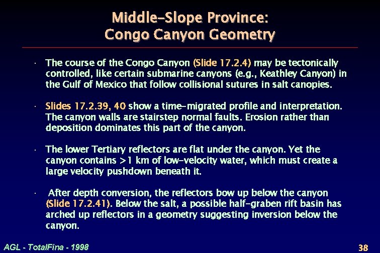
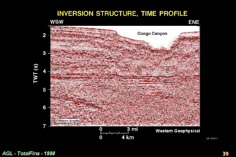
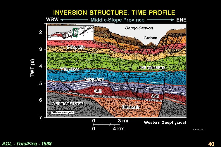
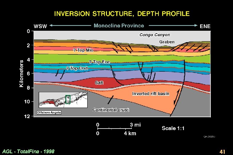
Middle-Slope Province: Congo Canyon Geometry · The course of the Congo Canyon (Slide 17. 2. 4) may be tectonically controlled, like certain submarine canyons (e. g. , Keathley Canyon) in the Gulf of Mexico that follow collisional sutures in salt canopies. · Slides 17. 2. 39, 40 show a time-migrated profile and interpretation. The canyon walls are stairstep normal faults. Erosion rather than deposition dominates this part of the canyon. · The lower Tertiary reflectors are flat under the canyon. Yet the canyon contains >1 km of low-velocity water, which must create a large velocity pushdown beneath it. · After depth conversion, the reflectors bow up below the canyon (Slide 17. 2. 41). Below the salt, a possible half-graben rift basin has arched up reflectors in a geometry suggesting inversion below the canyon. AGL - Total. Fina - 1998 38
Western Geophysical AGL - Total. Fina - 1998 39
Western Geophysical AGL - Total. Fina - 1998 40
AGL - Total. Fina - 1998 41
Middle-Slope Province: Congo Canyon Inversion · The inferred presence of an inverted rift basin below the Congo Canyon (Slide 17. 2. 41) may be coincidental, but structures fit logically. · Arching of cover above the inverted rift would stretch the outer arc of the arch, especially at the sea floor. Stretching would form a keystone graben. The keystone graben trough would tend to channel the canyon. Canyon erosion would be aided and guided by plucking out fault blocks. · A subsalt crustal boundary might have controlled the original rift basin. · This speculation is supported (but not proven) by the canyon’s pattern on a free-air gravity map. The 200 -km-long canyon trends straight, oblique to the shoreline, before curving southward distally. This straight trend parallels the major Conrad seamount chain off the Kwanza Basin at 11°S, which may not be purely coincidental. AGL - Total. Fina - 1998 42
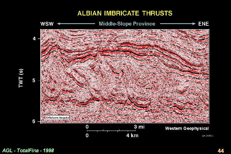
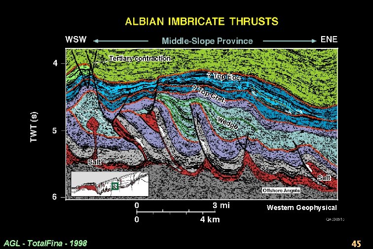
Middle-Slope Province: Mid-Cretaceous Thrust Belt · Small mid-Cretaceous thrust structures all appear to verge seaward (Slide 17. 2. 45). · Some may be laterally squeezed diapirs (extreme left). · We cannot determine whether the structures are thrust imbricates overlain by an erosion surface or a duplex overlain by a roof thrust. · Growth wedges between the thrusts indicate that they shortened mostly in Albian or Cenomanian time. · Shortening is coeval with the main extension farther landward, so this thrust belt could have absorbed much of the extension. · Minor shortening continued after the Cenomanian, as recorded by onlaps in the youngest Cretaceous interval. AGL - Total. Fina - 1998 43
Western Geophysical AGL - Total. Fina - 1998 44
Western Geophysical AGL - Total. Fina - 1998 45
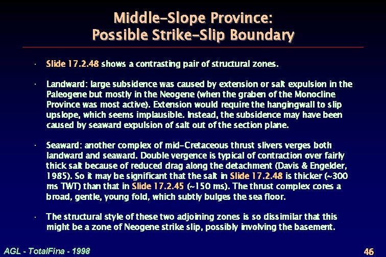
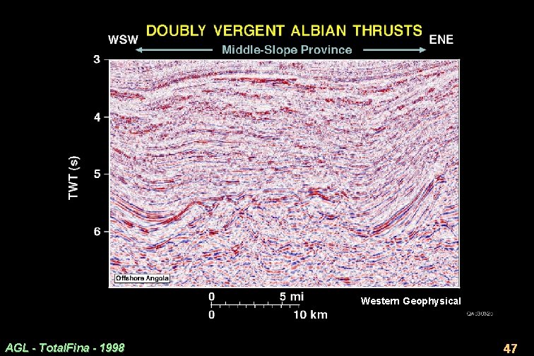
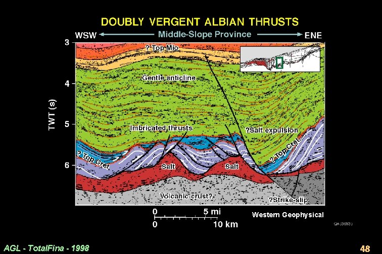
Middle-Slope Province: Possible Strike-Slip Boundary · Slide 17. 2. 48 shows a contrasting pair of structural zones. · Landward: large subsidence was caused by extension or salt expulsion in the Paleogene but mostly in the Neogene (when the graben of the Monocline Province was most active). Extension would require the hangingwall to slip upslope, which seems implausible. Instead, the subsidence may have been caused by seaward expulsion of salt out of the section plane. · Seaward: another complex of mid-Cretaceous thrust slivers verges both landward and seaward. Double vergence is typical of contraction over fairly thick salt because of reduced drag along the detachment (Davis & Engelder, 1985). So it may be significant that the salt in Slide 17. 2. 48 is thicker (~300 ms TWT) than that in Slide 17. 2. 45 (~150 ms). The thrust complex cores a broad, gentle, young fold, which subtly bulges the sea floor. · The structural style of these two adjoining zones is so dissimilar that this might be a zone of Neogene strike slip, possibly involving the basement. AGL - Total. Fina - 1998 46
Western Geophysical AGL - Total. Fina - 1998 47
Western Geophysical AGL - Total. Fina - 1998 48
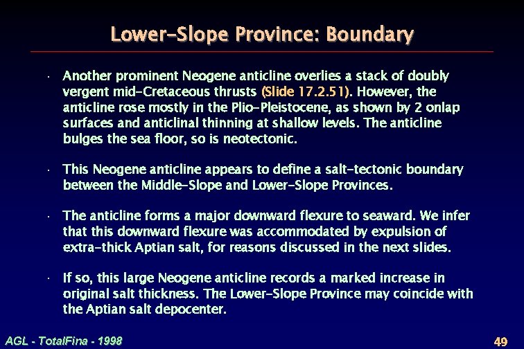
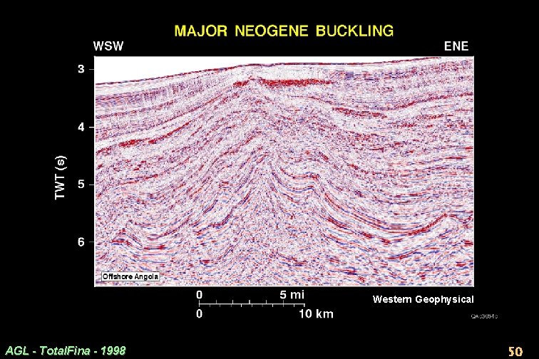
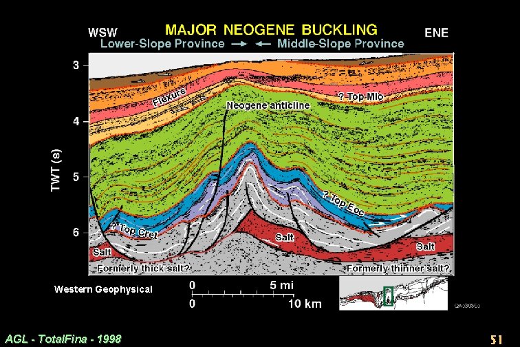
Lower-Slope Province: Boundary · Another prominent Neogene anticline overlies a stack of doubly vergent mid-Cretaceous thrusts (Slide 17. 2. 51). However, the anticline rose mostly in the Plio-Pleistocene, as shown by 2 onlap surfaces and anticlinal thinning at shallow levels. The anticline bulges the sea floor, so is neotectonic. · This Neogene anticline appears to define a salt-tectonic boundary between the Middle-Slope and Lower-Slope Provinces. · The anticline forms a major downward flexure to seaward. We infer that this downward flexure was accommodated by expulsion of extra-thick Aptian salt, for reasons discussed in the next slides. · If so, this large Neogene anticline records a marked increase in original salt thickness. The Lower-Slope Province may coincide with the Aptian salt depocenter. AGL - Total. Fina - 1998 49
Western Geophysical AGL - Total. Fina - 1998 50
Western Geophysical AGL - Total. Fina - 1998 51
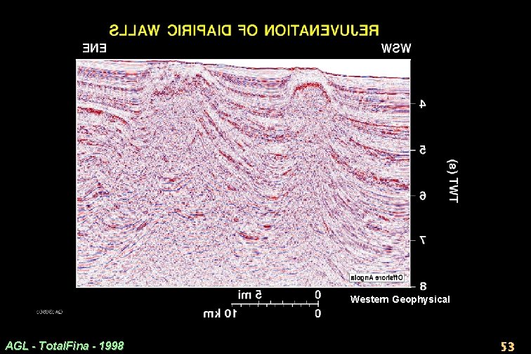
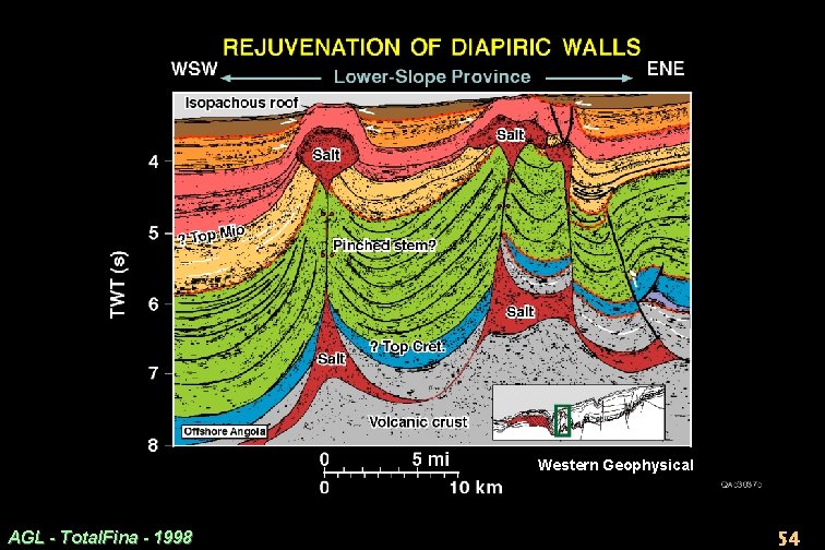
Lower-Slope Province: Growth of Salt Walls · The salt tectonics style changes radically across the Neogene anticline into a train of major, regularly spaced, salt walls (Slide 17. 2. 54). · Their large size, allochthonous offshoots, and possible canopies all suggest that the walls grew from thick salt. · The downward flexure in Slide 17. 2. 51 is associated with major Neogene thickening. · Thickening was accommodated either by a deepening basin floor or by expulsion of salt into the salt walls. The basin floor is too indistinct to elucidate these possibilities, but some expulsion of salt into the growing salt walls was inevitable. AGL - Total. Fina - 1998 52
Western Geophysical AGL - Total. Fina - 1998 53
Western Geophysical AGL - Total. Fina - 1998 54
Lower-Slope Province: Contractional Rejuvenation of Salt Walls · The crests of both salt walls bulge the sea floor and are onlapped by Pleistocene strata (Slide 17. 2. 54). · These diapirs are active today, probably owing to lateral squeezing. A position in the lower slope is prone to gravitationally imposed compression from the upper slope. · The diapirs could have risen actively, driven purely by the weight of the overburden on the source layer. · However, active diapirism is continually driven by gravity so is unlikely to have stopped in the Pliocene long enough for isopachous roofs to form, which are now bulging the sea floor. · Conversely, contraction is typically spasmodic: stable periods when stresses accumulate updip alternate with contractional pulses that rejuvenate the salt walls by squeezing their contents upward. AGL - Total. Fina - 1998 55
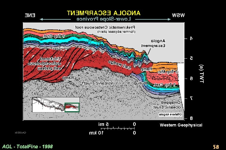
Lower-Slope Province: Internal Structure of Thickened Salt Plateau · Just seaward of the diapiric walls in Slide 17. 2. 54 is a broad plateau of Aptian salt, 3– 4 km thick (Slide 17. 2. 8). · Overlying isopachous Albian reflectors rise smoothly by 0. 5 to 1. 0 s TWT onto the rear of this salt plateau. This time shift is partly due to salt withdrawal landward of the plateau. · However, the internal structure of the salt plateau suggests that it has been tectonically thickened (Slide 17. 2. 58). · How? It is generally assumed that a salt plateau inflates purely by seaward inflow of salt from the adjoining source layer. · However, this salt plateau contains many oblique reflectors (Slide 17. 2. 58). Their systematic geometry resembles a thrust duplex or imbricate stack of thrust sheets. Basalt flows or clastic sediments imbricated with salt could create the oblique internal reflectors. · If the salt is internally imbricated, its bumpy upper surface would be a roof thrust separating a mildly buckled roof from a severely shortened thrust duplex within the salt plateau. AGL - Total. Fina - 1998 56
Western Geophysical AGL - Total. Fina - 1998 57
Western Geophysical AGL - Total. Fina - 1998 58
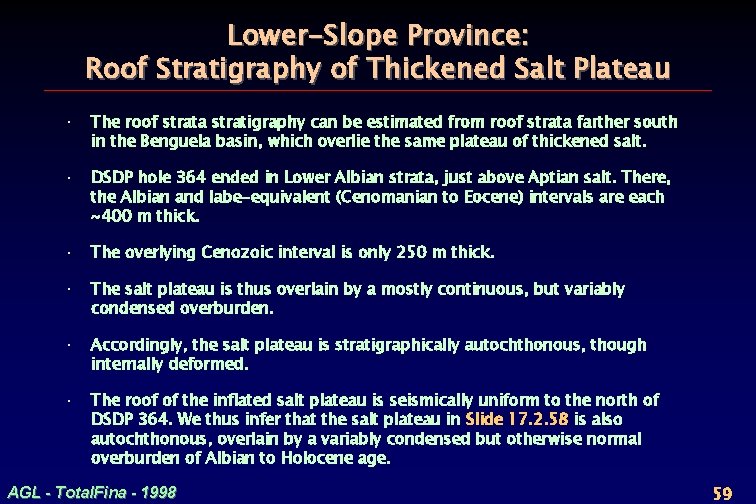
Lower-Slope Province: Roof Stratigraphy of Thickened Salt Plateau · The roof strata stratigraphy can be estimated from roof strata farther south in the Benguela basin, which overlie the same plateau of thickened salt. · DSDP hole 364 ended in Lower Albian strata, just above Aptian salt. There, the Albian and Iabe-equivalent (Cenomanian to Eocene) intervals are each ~400 m thick. · The overlying Cenozoic interval is only 250 m thick. · The salt plateau is thus overlain by a mostly continuous, but variably condensed overburden. · Accordingly, the salt plateau is stratigraphically autochthonous, though internally deformed. · The roof of the inflated salt plateau is seismically uniform to the north of DSDP 364. We thus infer that the salt plateau in Slide 17. 2. 58 is also autochthonous, overlain by a variably condensed but otherwise normal overburden of Albian to Holocene age. AGL - Total. Fina - 1998 59
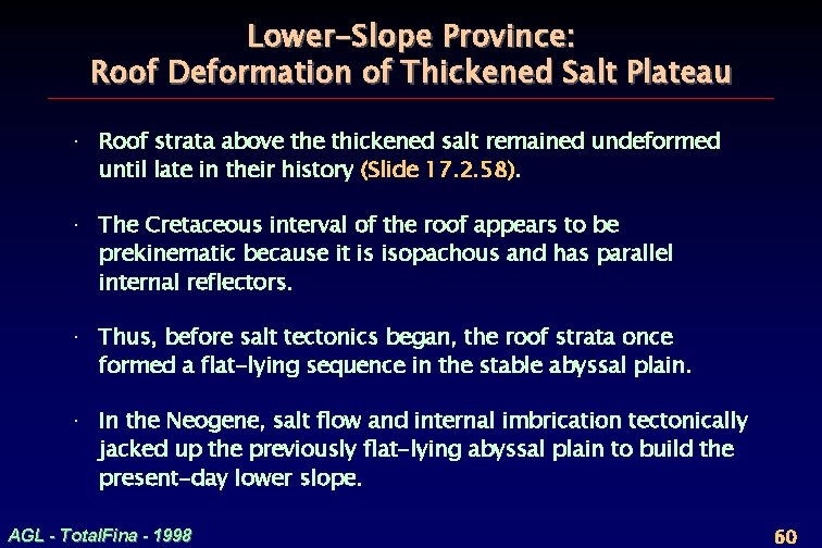
Lower-Slope Province: Roof Deformation of Thickened Salt Plateau · Roof strata above thickened salt remained undeformed until late in their history (Slide 17. 2. 58). · The Cretaceous interval of the roof appears to be prekinematic because it is isopachous and has parallel internal reflectors. · Thus, before salt tectonics began, the roof strata once formed a flat-lying sequence in the stable abyssal plain. · In the Neogene, salt flow and internal imbrication tectonically jacked up the previously flat-lying abyssal plain to build the present-day lower slope. AGL - Total. Fina - 1998 60
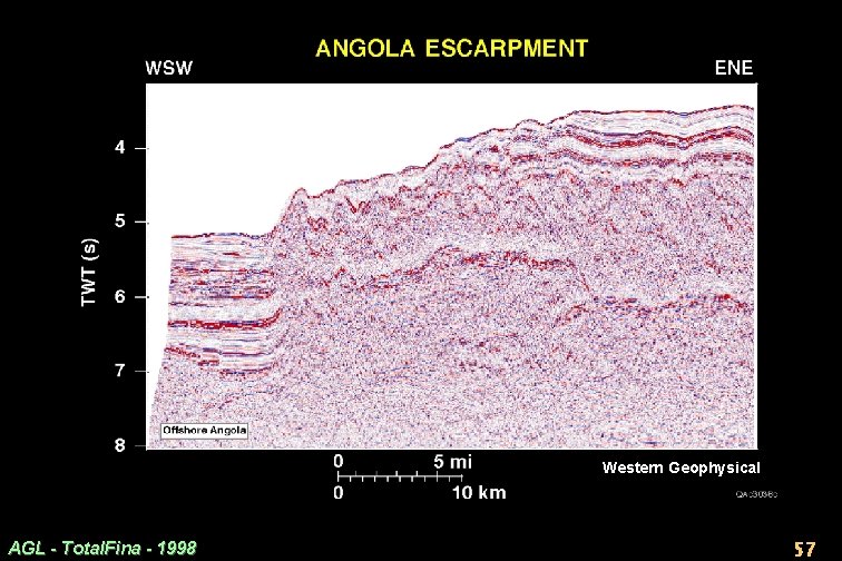
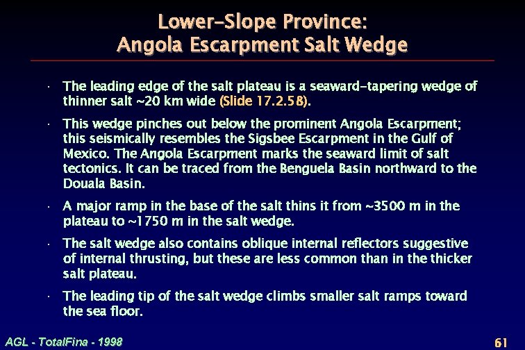
Lower-Slope Province: Angola Escarpment Salt Wedge · The leading edge of the salt plateau is a seaward-tapering wedge of thinner salt ~20 km wide (Slide 17. 2. 58). · This wedge pinches out below the prominent Angola Escarpment; this seismically resembles the Sigsbee Escarpment in the Gulf of Mexico. The Angola Escarpment marks the seaward limit of salt tectonics. It can be traced from the Benguela Basin northward to the Douala Basin. · A major ramp in the base of the salt thins it from ~3500 m in the plateau to ~1750 m in the salt wedge. · The salt wedge also contains oblique internal reflectors suggestive of internal thrusting, but these are less common than in the thicker salt plateau. · The leading tip of the salt wedge climbs smaller salt ramps toward the sea floor. AGL - Total. Fina - 1998 61
Lower-Slope Province: Crust and Cover Below Salt Wedge · This salt wedge fringing the salt province has ambiguous but potentially important implications. · These hinge on the nature of the subsalt rocks, which coincide with a prominent Bouguer residual high (Slide 17. 1. 48). The underlying crust is likely to be dense— perhaps a basement uplift or mafic rocks. · Above this dense crust, layered rocks underlie the salt wedge and continue horizontally across the abyssal plain. · Most subsalt reflectors are poorly imaged (Slide 17. 2. 57). But on some nearby lines, subsalt reflectors are clear and continuous; they appear to be flat-lying in true depth, as in large areas of the Gulf of Mexico (Diegel et al. , 1995; Peel et al. , 1995). · These reflectors are distorted by 3 velocity effects. Strata below the abyssal plain are depressed relative to the base of the slope because of (1) deeper sea water, (2) thicker Tertiary interval, and (3) absence of salt. · ~800 ms of pullup below the Angola Escarpment (Slide 17. 2. 58) was calculated empirically from nearby lines where the subsalt reflectors are clear and laterally continuous. AGL - Total. Fina - 1998 62
Lower-Slope Province: Tectonic Implications of Salt Wedge · Even minor shifts in the estimated velocity pullup discussed in Slide 17. 2. 62 have huge tectonic implications, discussed in the following slides. · A large velocity pullup supports a conservative tectonic hypothesis. · Conversely, a slightly smaller pullup supports a much more radical tectonic hypothesis. AGL - Total. Fina - 1998 63
Lower-Slope Province: Conservative Thrust Nappe? · Our estimate of ~800 ms pullup has tectonically conservative implications. · Subsalt reflectors (Top Albian and Base Oligocene) are cut off by the salt wedge ~2 km and ~1 km, respectively, landward of the salt pinchout (Slide 17. 2. 58). · Thus, Cretaceous strata might overlap above and below the salt wedge tip. Stratigraphic repetition is uncertain here because: (1) cutoffs of strata against the base of the salt have been calculated, not directly observed, (2) the suprasalt structure is poorly imaged above the salt wedge tip. · Any repeated section indicates Tertiary overthrusting. The thrust nappe comprises the gently buckled roof riding on thickened salt and its fringing wedge. The roof nappe would be displaced a few km seawards. · If this scenario is correct, rocks below the salt wedge must be either uplifted pre-salt (pre-Aptian) terrane or some kind of syn-salt volcanic pile; both are compatible with the observed gravity high. The subsalt lithology is unknown but could include subaerial flood basalts (Chapter 1). · Against this topographic high, the Aptian salt could have ponded while accumulating. The overlying salt wedge could represent: (1) an expansion of the original salt basin over time, or (2) an allochthonous glacier extruded seaward from the original basin margin. AGL - Total. Fina - 1998 64
Lower-Slope Province: A Radical Thrust Nappe? · If our estimate of velocity pullup is slightly too high and the real pullup is, say, <700 ms, tectonic transport could be much more than a few km, perhaps >20 km along the seaward fringe of the Kwanza salt province. . · With less velocity pullup, reflectors would pass landward beneath the salt wedge, perhaps as far as 20 km to be cut off against the main salt ramp (Slide 17. 2. 58). · Major implications of this hypothesis. – The main ramp marks the original edge of the autochthonous salt basin. – The entire salt wedge is an allochthonous sheet that extruded seaward out of the original salt basin and across post-Aptian strata. – This allochthonous sheet lubricated a 20 -km-overthrusted thrust nappe. – The Angola Escarpment is the steep toe of the Angola thrust nappe. · Gentle buckling of the roof of the thrust nappe adds a little extra shortening. · Moreover, 20 km is a minimum estimate of cumulative shortening of strata because more contractional structures are inferred farther landward. These are mostly buckle folds and pinched diapers, whose closure could account for much more shortening than in the gently buckled roof of the salt wedge. · Speculations on shortening refer only to post-salt strata. If imbricated, the interior of the salt plateau must be far more shortened than its roof—hence the need for a duplex roof thrust along the base of the roof (Slide 17. 2. 58). AGL - Total. Fina - 1998 65
Abyssal Plain · Here, the seismic record is unobscured because salt is absent. · The acoustic basement resembles typical oceanic crust (mounded, hummocky basement surface overlying chaotic reflectors), including the flank of a possible volcano on the extreme left of Slide 17. 2. 58. Acoustic basement rises gradually westward towards the midoceanic ridge. · Strata in the abyssal plain seismically resemble the roof strata above the inflated salt. This similarity is expected. We infer that both strata once formed the same abyssal plain. Prekinematic roof strata should merge seawards into similar prekinematic strata in the present abyssal plain. · Cretaceous strata in the abyssal plain are thus inferred to comprise ~400 m of Pinda equivalent (Albian) and ~400 m of Iabe equivalent (Cenomanian to Eocene). · Overlying strata are inferred to be the Cenozoic interval, 3– 4 times as thick as over the tectonically elevated salt plateau. AGL - Total. Fina - 1998 66
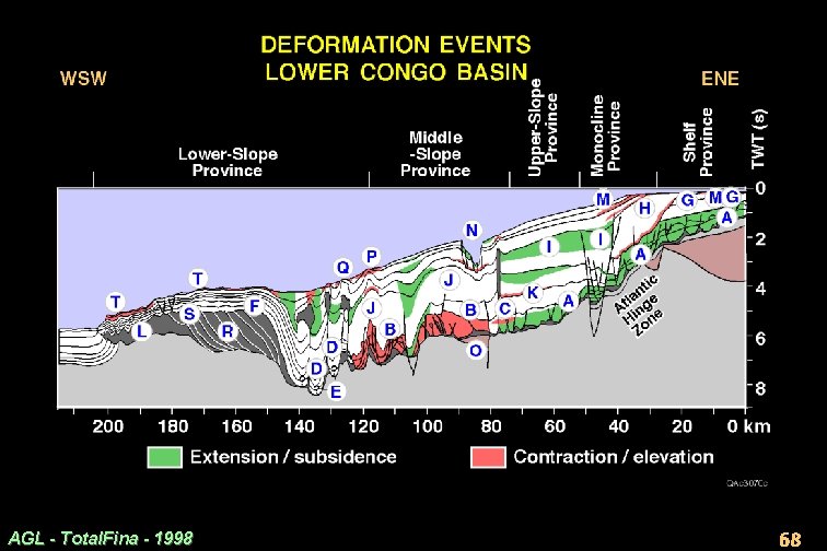
Superposed Deformation Events: Synthesis · Here, we summarize the deformation in a time sequence rather than from place to place. · Slide 17. 2. 68 shows 2 types of deformation zones: (1) zones of either extension or subsidence below regional, (2) zones of either contraction or uplift above regional. · These zones are shown in 2 -D space, but their stratigraphic position also records when the deformation took place. · The timing of deformation becomes increasingly uncertain into deep water away from wells. · As many as 8 deformation events can be inferred from this profile. However, these events are more manageable if grouped into 3 episodes: Late Cretaceous, Mid-Cenozoic, and Neogene. AGL - Total. Fina - 1998 67
AGL - Total. Fina - 1998 68
Late-Cretaceous Events: Proximal Region · A backstepping carbonate wedge rested on salt and originally dipped seaward at 1– 3. · This gentle, regular slope drove Late Cretaceous gravity spreading. · Extensional rafting took place from the shelf to the boundary with the Middle-Slope Province (A in Slide 17. 2. 68). · Farther downdip, strata contracted, probably seaward to the foot of the backstepping wedge (B). · The contractional zone may have propagated slightly updip, where extensional diapirs and rafts were compressed in a narrow zone (C). · Spreading subsided after the overburden thickened and strengthened and thermal subsidence decayed. AGL - Total. Fina - 1998 69
Late-Cretaceous Events: Distal Region · Farther down the present slope, massive salt walls were triggered (D in Slide 17. 2. 68). These diapirs may have pierced erosionally unroofed buckle anticlines, but the seismic record is too obscure to indicate their origin and deep structure. · The Cretaceous interval here could be thin if it accumulated over an inflated salt plateau that later migrated seaward ahead of the prograding margin (E). · Beyond the salt walls, isopachous strata roofing the present salt plateau indicate accumulation in a flat abyssal plain away from any tectonic disturbance during the Cretaceous (F). AGL - Total. Fina - 1998 70
Mid-Cenozoic Events: Proximal Region · The Monocline Province was created in the Late Oligocene as the shelf and coastal plain rose by 2– 3 km. Erosion stripped Paleogene cover off the shelf and cut several km into the underlying Cretaceous carbonate platform (G in Slide 17. 2. 68). · That erosion caused the shelf break to retreat landward by as much as 30 km. · Monoclinal steepening created major accommodation space for Miocene progradation, which was enhanced by a major eustatic fall of 0. 3 km (H). · Steepening also triggered a major episode of renewed gravity spreading. · The major graben in the monocline widened and caused Miocene strata to rotate landward toward the graben (I). · Seaward of the present Congo Canyon, another large half graben deepened, probably by expulsion of underlying salt. AGL - Total. Fina - 1998 71
Mid-Cenozoic Events: Distal Region · In the Middle-Slope Province, the entire thickness of the overburden on the slope began to buckle gently on a wavelength of 20– 30 km (J in Slide 17. 2. 68). Buckling began in the Eocene (K). · The originally thick salt was depleted by expulsion into downbuilding diapiric walls. · The roof of the present salt plateau remained undeformed and flat-lying in what was then an abyssal plain. · However, the salt could have broken out and flowed glacially over the sea floor to create an allochthonous sheet above younger strata (L). · Alternatively, this salt wedge could have previously accumulated autochthonously by seaward enlargement of the original salt basin in the Late Cretaceous. AGL - Total. Fina - 1998 72
Neogene Events: Proximal Region · Minor upwarping of 10 s to 100 s of meters took place at the present shelf break (M in Slide 17. 2. 68). · That could have been followed by further uplift of the shelf and coast, but no sedimentary record exists. · The modern Congo Canyon may have been structurally channeled along a graben (N). The graben seems to overlie an inverted subsalt half-graben (O). We speculate that this inversion arched the salt’s overburden and created a keystone graben, which localized the present Congo Canyon. AGL - Total. Fina - 1998 73
Neogene Events: Distal Region · In the lower slope, major anticlinal flexures continued amplifying to the present day (P in Slide 17. 2. 68). · Adjoining salt walls are also still rising, possibly because of lateral squeezing by the prograding wedge (Q). · The original salt thick below these walls was displaced seaward to form the modern plateau of thickened salt, which jacked up its previously undeformed abyssal roof and built the present lower slope (R). · The salt could have thickened by lateral flow of salt. · Instead, it seems to have thickened by duplex thrusting of interbedded and imbricated sediments or flood basalts. · The tectonically thickened salt is probably separated from its clastic roof by a duplex roof thrust (S). · The roof buckled gently in its lower reaches (T) and appears to have been overthrust for an uncertain distance ranging from 1 to 20 km. AGL - Total. Fina - 1998 74
Complexity of Polyphase Deformation · A divergent continental margin is typically envisaged to comprise 3 zones: (1) landward extension (2) seaward contraction (3) intervening translation. · Progradation of this margin should systematically superpose extension on contraction as deformation zones shift seaward. · In contrast, Slide 17. 2. 68 illustrates superposed deformation that is more complex than even a shifting three-fold zonation (allowing for the composite nature of the line). · Superposed deformation events in the Angolan margin cannot be explained simply by progradation. Deformation occurred in pulses in a wide variety of locations, times, and sequences. AGL - Total. Fina - 1998 75
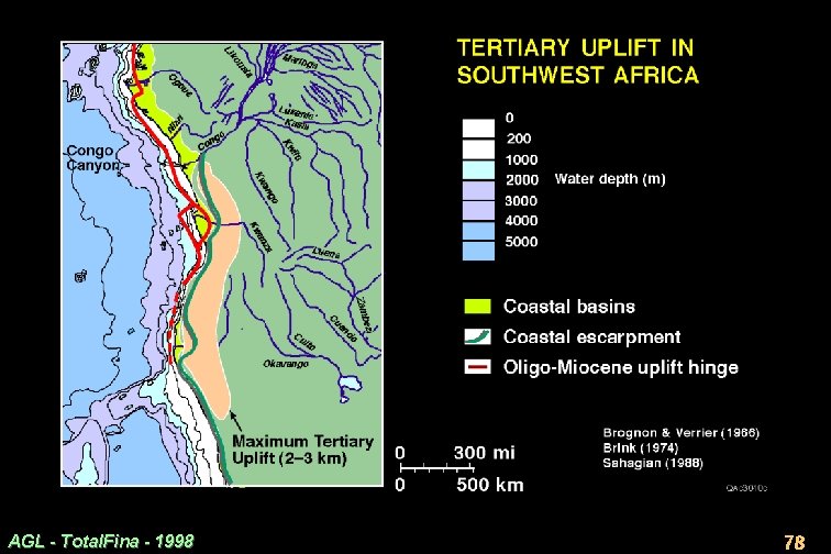
Causes of Polyphase Deformation · Nonsystematic sequences of deformation led some geologists to propose that deformation zones could shift intermittently landward in response to eustatic rise (Raillard et al. , 1996). · However, any landward shifts of depocenters caused by eustasy are dwarfed by tectonic events such as the 3 -km vertical offset in the Monocline Province. · The absolute uplift of the shelf and coastal plain that created this monocline seems to have initiated deformation that had a chain effect far down the slope. · Deformation zones in the composite regional section appear to have been influenced by: (1) progradation of the margin (2) epeirogenic rise of the shelf and coastal plain in the Oligocene and the Neogene (Slides 17. 2. 77, 78). AGL - Total. Fina - 1998 76
Tertiary Uplift of Angolan Margin · Slide 17. 2. 78 shows physiographic elements of Tertiary uplift. · Orange line: the Atlantic Hinge Zone and other elements form the Monocline Province, which roughly underlies the modern shelf break (data from proprietary seismic). This flexure in the base of salt moves onshore in the Gabon Basin (Brink, 1974) and in Kwanza Basin (Brognon and Verrier, 1966), where it splits into onshore and offshore branches. · Pale brown area: a region of 2 -3 km of Tertiary uplift (calculated by Sahagian, 1988, from present elevations of Cretaceous shoreline deposits). · Dark green line: the present coastal escarpment represents the retreating scarp of 2 superimposed uplifts: (1) Cretaceous Parana-Etendeka hotspot, which split during continental breakup (Chapter 1). (2) Tertiary uplift, which reversed the flow of river systems (e. g. , Okavango) into the continental interior. Uplift could be thermally induced, as the African plate came to rest over mantle plumes at ~30 Ma (Burke, 1996). AGL - Total. Fina - 1998 77
AGL - Total. Fina - 1998 78
References, Part 1 Brink, A. H. , 1974, Petroleum geology of Gabon Basin: AAPG Bull. , 58, 216– 235 Brognon, G. , and Verrier, G. R. , 1966, Oil and geology in Cuanza basin in Angola: AAPG Bull. , 50, 108– 158 Burke, K. , 1996, The African Plate: S. African J. Geology 99, 341– 410 Davis, D. M. , and Engelder, T. , 1985, The role of salt in fold-and-thrust belts: Tectonophysics 119, 67 -88 Diegel, F. A. , J. F. Karlo, D. C. Schuster, R. C. Shoup, and P. R. Tauvers, 1995, Cenozoic structural evolution and tectono-stratigraphic framework of the northern Gulf Coast continental margin, in M. P. A. Jackson, D. G. Roberts, and S. Snelson, eds. , Salt tectonics: a global perspective: AAPG Memoir 65, p. 109 -151 Duval, B. , Cramez, C. and Jackson, M. P. A. , 1992, Raft tectonics in the Kwanza Basin, Angola Mar. Petrol. Geol. 9, 389– 404 Karner, G. D. , Driscoll, N. W. , Mc. Ginnis, J. P. , Brumbaugh W. D. and Cameron, N. R. , 1997, Tectonic significance of syn-rift sediment packages across the Gabon-Cabinda continental margin Mar. Petrol. Geol. 14, 973– 1000 Lavier, L. , Brigaud, F. , and Steckler, M. S. , 1995, Reconstruction of the Cenozoic development of the Angolan continental margin: Amer. Geophys. Union Spring Meeting, S 284. Lonergan, L. , Cartwright, J. , and Jolly, R. , 1998, The geometry of polygonal fault systems in Tertiary mudrocks of the North Sea: J. Structural Geol. 20, 529– 548 Lundin, E. R. , 1992, Thin-skinned extensional tectonics on a salt detachment, northern Kwanza Basin, Angola: Mar. Petrol. Geol. 9, 405– 411 AGL - Total. Fina - 1998 79
References, Part 2 Lundin, E. R. , 1992, Thin-skinned extensional tectonics on a salt detachment, northern Kwanza Basin, Angola: Mar. Petrol. Geol. 9, 405– 411 Meyers, J. B. , Rosendahl, B. R. , Groschel-Becker, H. , Austin, J. A. , Jr. and Rona P. A. , 1996, Deep penetrating MCS imaging of the rift-to-drift transition, offshore Douala and North Gabon basins, West Africa Mar. Petrol. Geol. 13, 791– 835 Peel, F. J. , C. J. Travis, and J. R. Hossack, 1995, Genetic structural provinces and salt tectonics of the Cenozoic offshore U. S. Gulf of Mexico: a preliminary analysis, in M. P. A. Jackson, D. G. Roberts, and S. Snelson, eds. , Salt tectonics: a global perspective: AAPG Memoir 65, p. 153 -175. Raillard, S. , Allix, P. , Guerin, G. , Mauduit, T. , Lecanu, H. , and Brun, J. P. , 1966, Eustatic control of gravity tectonics: concept, mechanism and limits: AAPG Annual Meeting, A 117 Sahagian, D. , 1988, Epeirogenic motions of Africa as inferred from Cretaceous shoreline deposits: Tectonics 7, 125 -138 Spathopoulos, F. , 1996, An insight on salt tectonics in the Angola Basin, South Atlantic: in G. I. Alsop, D. J. Blundell, and I. Davison (Eds. ) Salt tectonics, Geol. Soc. London Spec. Publ. 100, 153– 174 Steckler, M. S. , Lavier, L. L. , and Brigaud, F. , 1997, Reconstruction of the Cenozoic tectonic and sedimentary history of the Congo-Angola margin: Amer. Geophys. Union Fall Meeting, F 658 Uenzelmann-Neben, G. , Spiess, V. , and Bleil, U. , 1997, A seismic reconnaissance survey of the northern Congo Fan: Marine Geol. 140, 283– 306 Walgenwitz, F. , Pagel, M. , Meyer, A. , Maluski, H. , and Monie, P. , 1990, Thermo-chronological approach to reservoir diagenesis in the offshore Angola Basin: a fluid inclusion, 40 Ar-39 Ar and K-Ar investigation: AAPG Bull. 74, 547– 563. AGL - Total. Fina - 1998 80