Chapter 18 Section 1 Landforms Resources PHYSICAL GEOGRAPHY


- Slides: 33
Chapter 18 Section 1: Landforms & Resources PHYSICAL GEOGRAPHY OF AFRICA: THE PLATEAU CONTINENT
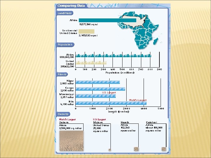
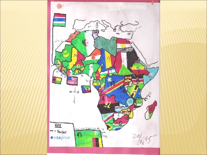
PHYSICAL & POLITICAL MAP OF AFRICA
BLOOD DIAMONDS Diamonds in Africa has been a source of conflict and war. Angola’s rebel used diamonds to keep their forces fighting with the bargaining of arms dealers and international traders. It has also enriched countries such as Botswana & South Africa. The sale of diamonds have funded a war that killed more than 500, 000 Angolans and left more than 4 million homeless.
AFRICA’S WEALTH OF RESOURCES Minerals: 1. Gold, platinum, chromium, cobalt, copper, phosphates, diamonds & many other minerals. South Africa: largest produces of chromium (stainless steel); 80% of world’s platinum & 30% of the world’s gold. Cobalt, a high grade steel for aircraft & industrial engines. African nations produce about 42% of it for the world; mostly in Democratic Republic of the Congo & Zambia. Ore & minerals account for more than half of it exports. Oil: 3. Libya, Nigeria & Algeria are among the world’s leading petroleum producers. Angola & Gabon huge untapped oil reserves. Libya, Nigeria & Algeria & Angola History: 2. In the 19 th & 20 th centuries European colonial rulers developed Africa’s natural resources for export to Europe to manufacture goods there. As a result, many nations have been slow to develop the infrastructure and industries to turn resources into valuable products. 4. Angola recently discovered offshore oil deposits; this will enable its government to spend the money on an ongoing civil war. Cause by ethnic division resulting from years of colonialism. Little investments in schools, hospitals, or infrastructure. Africa’s great mineral wealth has
DIVERSITY OF RESOURCES Rainforest to roaring river; Africa is very in diverse in resources. Agricultures is the single most important economic activity in Africa. 66% of Africans earn their living from farming & farms products account for nearly 1/3 of the continent’s export. Commodities: 5. Coffee: 20% of the world coffee is grown here, even though few Africans drink it. Lumber: Nigeria leads African nations in lumber exports & ranks 8 th worldwide. Negative: It is depleting Africa’s forests. Every year loggers clear an area twice the size of New Jersey. Sugar, palm oil & cocoa. 6. Agricultural resources are important to Africa and provide a livelihood for many Africans.
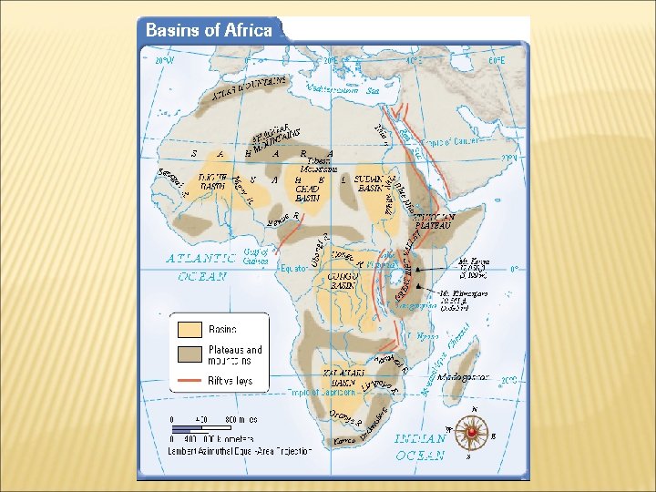
A VAST PLATEAU Africa’s Plateau: 1. A huge plateau cover most of Africa With the exception of Mozambique and Somalia, all of Africa lies about 1000 ft. above sea level Geographer know it as the “plateau continent” Basin: Each basin is about 625 miles across and 5, 000 ft. deep. 2. Water collects in the Chad Basin & rivers flows through the Sudan, Congo & Djouf basin.
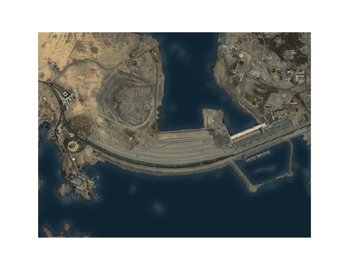
DISTINCTIVE AFRICAN LANDFORMS Rift Valleys & Lakes: 3. Rift valleys located in East Africa As the continental plates pulled apart over millions of years, huge cracks appeared in the earth & within time the sank creating long & thin valleys. 4, 000 miles long from Jordan to Mozambique. Lakes have formed at bottom of these rift valley. Lake Tanganyika: longest fresh water lake in the world, 420 miles long & 4, 700 in depth. Lake Victoria: 2 nd largest freshwater lake, only 270 in
RIFT VALLEY
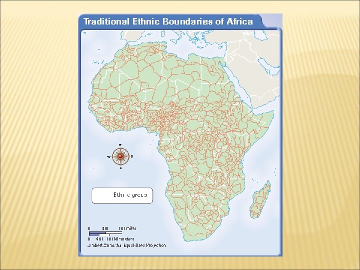
POPULATION DENSITY/ LANGUAGES
ANGOLA’S OIL WOES Angola has huge offcoast oil reserves Most citizens remain poor farmers Lack of infrastructure, mismanagement, gvt corruption, and a long , bloody, civil war to blame GPD increased 465% in last decade
Section 2 CLIMATE AND VEGETATION
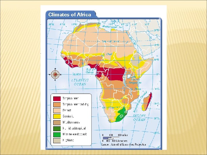
A WARM CONTINENT Deserts: 1. The Sahara, largest desert in the world. Sahara mean desert in Arabic. 3, 000 miles, from the Atlantic Ocean to the Red Sea & about 1200 miles north to south. Temp. can rise as high as 136 degrees to freezing at night in the winter; & other Africans deserts, the Kalahari & the Namib. 2. 20% of it consist of sand, mts. Rock formation & dry plains make up the rest. Tibesti Mts. Elevation of 11, 000 fts. Aquifers & oasis support vegetation & wildlife; critical for people living here. Tropics: 3. 90% of the continent lies within the tropics. 4. July temperatures average between 110 to 115 degrees. An old saying, “Night time is the winter of the tropics”
SUNSHINE & RAINFALL Moderates areas: 5. A Mediterranean climate exists on the northern & southern tips of the continents. 6. Rain falls in the winter in North Africa & June & July in Southern Africa.
A GRASSY CONTINENT Grassland: 7. Tropical grassland covers most of the continent such as the Serengeti Plain in northern Tanzania. World best grassland. 8. What makes its special is that the hard soil & dry climate makes its difficult to grow trees & many crops, but it is perfect for growing grass. Some of the grass grows taller than the average person & make it suitable for grazing animals: wildebeests, gazelles, & zebras roam in the Serengeti National Park. Animals still make annual migrations.
AFRICA’S EXTREMES Rain Forest: 9. Congo Basin; a square acre of forest can contain 100 different types of trees. In the equator and in Ethiopia. 10. Home to hundreds species of birds. The canopy of trees which are about 150 fts. In height block the sunlight & makes it possible for different animals to live and decompose there. Example: Europe a leaf with take about a year, here about 6 weeks. Birds, monkeys, flying foxes, & snakes. Rainfall patterns: 1. Central Africa receives the majority of the precipitation year round. Other parts has one or two rainy seasons. The closer you are to the equator the more rain it receives, Plant life: Slash-and-burn agricultural methods are endangering the rain forest. When soil is exhausted they move on to another area. It has been the nearly complete destruction of Madagascar’s rain forest. 2. North Africa: oak trees & pine forests in the Atlas Mts. West Africa: Mangrove tree, the roots are great for fish, but they dry up the land by holding silt.
Chapter 18 Section 3 HUMAN-ENVIRONMENT INTERACTION
HUMAN PERSPECTIVE Niger delta, a region that contains most of Nigeria’s oil. An incident that happen on July 10, 2000 killed more than 300 people. An explosion shook the area and a fire spread along a mile-long stretch of the pipeline. This is just one of many accidents that have claimed the lives of hundreds of Nigerians. Nigeria has become one of the top oil producers in the world, but at a cost of thousand of lives & major environmental ruins.
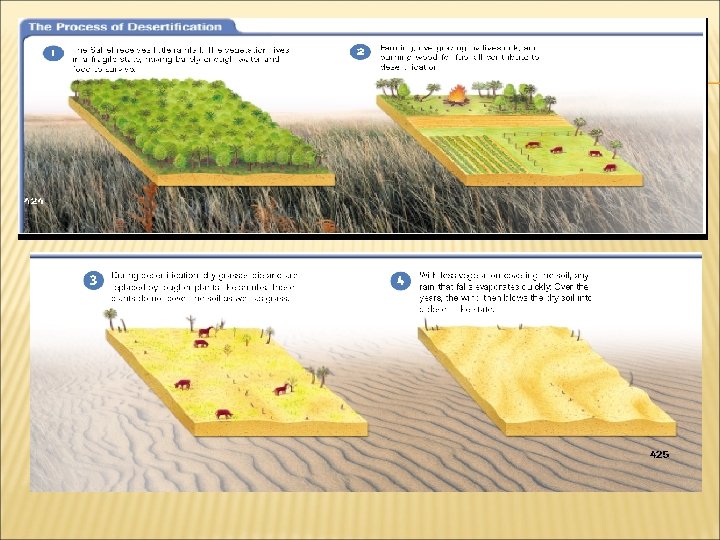
DESERTIFICATION OF THE SAHEL Sahel means “shore of the desert” in Arabic. It receives little rainfall. The area has enough water and food to survive. People have used this area for farming & herding; since the 1960 s the desert has spread in the Sahel. 1. Desertification is an expansion of dry condition into moist areas next to deserts. Human activity is speeding this process. Humans: 2. Overgrazing of vegetation by livestock exposes the soil. Animals trample open land. Farming increase pace of Desertification; expose soil to wind, erosion. Drill for Irrigation increase salt levels in the soil. Affect the growth of vegetation. Population growth; indirect affect. More people more food. Clear more land, burn more wood for fuel and over farm the land. Results: 3. Forest have depleted. Khartoum, Sudan and a tropical rainforest in Lake Chad. Hard to stop, but getting educated.
HARMING THE ENVIRONMENT IN NIGERIA 1. In 1956, oil found in Nigeria. In the 70 s, high oil prices made it ones of the wealthiest countries. 80 to 90% of Nigeria’s income. As a result the government borrow on future sales. Oil prices fell. It left Nigerian Govt. in debt to U. S. & other nations. Plus, poor planning & corruption left them poorer than before. Drilling for oil & foreign oil companies damaged the land & harm people way of life. More than 4, 000 oil spills in the Niger delta within the last 40 years. Cleanup slow and non-existence. Fire occurred, causing acid rain, deposit of soot; thus causing respirator diseases. 2. 1998 -2000, oil pipeline explosions killed more than 2, 000 people. Some accidentals, but other by bandits, in cooperation with corrupt government official. Drain pipeline and sell fuel; villagers come afterward to get
TODAY In May 1999, Olusegun Obasanjo became president of Nigeria. He distance himself from armed forces. He started economic reforms & fired corrupt govt. officials. President Goodluck Ebele Jonathan (inaugurated 6 May 2010) Member of United Nation & OPEC Over half of the population live in extreme poverty. Nigeria is off track to meet all the Millennium Development Goals (MDGs). Northern Nigeria has the world’s worst human development indicators outside conflict and post-conflict zones.
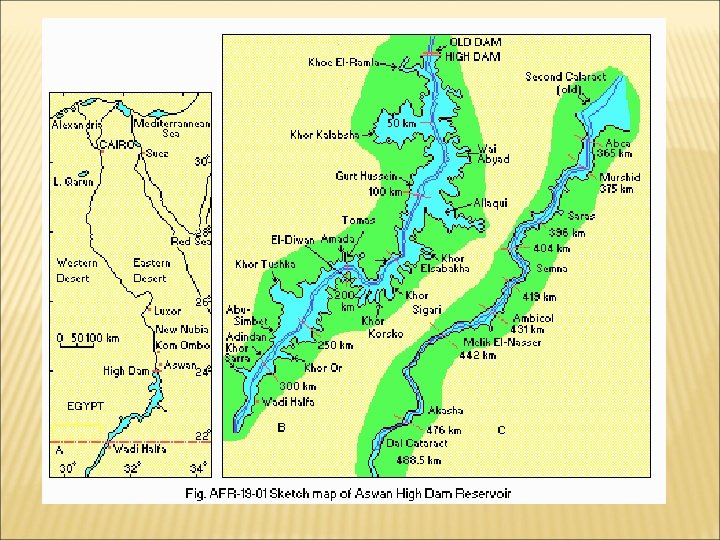
CONTROLLING THE NILE Aswan High Dam: It was built in 1970. Lake Nasser, which Egypt shares with Sudan is an artificial lake created behind the dam. 300 miles 3. It gives farmers regular supply of water. Hold floods waters & only release them when needed. Farmers now have 2 to 3 harvests per year instead of 1. Some year round. Increase farmable land by 50%. Helped avoid droughts & floods. Problems with Dam: 4. People had to be relocated; thousand of Nubians way of life changed. Egypt’s treasures, the temples Abu Simbel, had to be moved. Other lie in the bottom of Lake Nasser. Fertility is decreased; no deposit of silt (sediment). Farmers have to depend on fertilizers. Raising water table. Salts from deep in the earth have decrease the fertility of soil. (floodwater used to flushed out the salt. )
LAKE NASSER
MEASURING SUCCESS RATE It is hard to measure it success. Malaria & other diseases have increased. Since, Lake Nasser holds the floodwaters, Egyptians lose millions of gallons of fresh water to evaporation. For all the benefits, it has also had it problems.