Chapter 15 Earths Oceans Oceanography Our global ocean

Chapter 15 Earth’s Oceans

Oceanography • Our global ocean consists of one vast body of water that covers more than two-thirds of Earth’s surface. • Oceanography is the scientific study of Earth’s oceans. • In 1871, under the recommendations of the Royal Society of London, the British government sponsored an expedition to explore world's oceans and conduct scientific investigations. • With that, oceanography began as a quantifiable science. In 1872 the Scots Charles, Wyville Thompson and Sir John Murray launched the Challenger expedition (1872– 1876).

Oceanography • Technologies such as sonar, floats, satellites, submersibles, and computers are the central components that Oceanographers use to study the ocean today.

Technologies on the surface • Sound Navigation and Ranging is used by oceanographers to learn more about the topography of the ocean floor. • To determine ocean depth, scientists send a sonar signal to the ocean floor and time how long it takes for the sound to reach the bottom and return to the surface as an echo.

Technologies on the surface • Side-Scan Sonar is a technique that directs sound waves to the sea floor at an angle so that sides of underwater hills and topographic features can be mapped. other

Technologies on the surface • Oceanographers use floats that contain sensors to learn more about water temperature, salinity, and the concentration of gases and nutrients in surface water. • Floats can also be used to record wave motion and the speed at which currents are moving.

Technologies on the surface • Satellites continually monitor the ocean’s surface temperatures, currents, and wave conditions. • One satellite, TOPEX/Poseidon, uses a highfrequency signal that is transmitted from the satellite to the surface of the ocean. A receiving device then picks up the returning echo as it is reflected off the water.

Technologies in the water • Submersibles, underwater vessels which can be remotely operated or carry people to the deepest areas of the ocean, have allowed scientists to explore new frontiers. • Alvin is a modern submersible that can take two scientists and a pilot to depth as deep as 4500 m. Alvin has been used to discover geologic features such as hydrothermal vents and previously unknown sea creatures. It can also be used to bring sediments and water samples to the surface.

Technologies on land • Computers are an integral tool in both the collection and analysis of data from the ocean. • Information from satellites and float sensors can be transmitted and downloaded directly to computers. • Ocean models provide information about subsurface currents that can’t be directly observed. • These models play a role in simulating the Earth’s changing climate as well as simulating tides, tsunamis, and the dispersion of coastal pollution.

Where did water come from? • Geologic clues indicate that oceans have existed since the beginning of time. • Scientists hypothesize that Earth’s water originated from comets and meteorites. • Both contain and/or accumulate water as they travel through space. The water was released as they impacted the Earth. Video

Volcanism • Significant quantities of gasses that consist of mostly water vapor and carbon dioxide are emitted during volcanic eruptions. • When the Earth was forming, massive volcanic eruptions took place over millions of years, spewing these gasses into the sky and forming the Earth’s atmosphere. • As the Earth’s crust cooled, the water vapor gradually condensed and fell to the surface as precipitation and accumulated to form oceans.

The Blue Planet • Approximately 71% of the earth’s surface is covered by oceans. • All of earth’s landmasses are like large islands, almost entirely surrounded by water. • All the oceans are one vast, interconnected body of water. They have been divided into specific oceans and seas largely because of historic and geographic considerations.

Sea Level • Sea Level is the level of the oceans surface. • It has risen and fallen by hundreds of meters in response to melting ice during warm periods and expanding glaciers during ice ages. • Other processes that affect sea level are tectonic forces that lift or lower portions of Earth’s crust. • Currently, sea level is rising by 3 mm per year.

Major Oceans • There are three major oceans and two polar oceans: the Pacific, the Atlantic, the Indian (major), the Arctic, and the Southern (polar). • The Pacific Ocean is the largest. It contains half of the Earth’s seawater and is larger than all of Earth’s landmasses combined. • The Atlantic is the second largest ocean; it extends from Antarctica to the Arctic Circle. North of the Arctic Circle it is often referred to as the Arctic Ocean. • The third largest ocean is the Indian Ocean. It is mainly located in the southern hemisphere. • The storm-lashed region surrounding Antarctica, south of about 50° south latitude, is known as the Southern Ocean.

Polar Oceans • The Arctic and Southern oceans are covered by vast expanses of sea ice. • As sea-ice crystals form, and ice-crystal slush develops at the surface of the water. This eventually solidifies into round chunks called pancake ice. • These pieces eventually freeze into one continuous sheet called pack ice. In the coldest parts of the Arctic and Southern oceans, there is no summer thaw. These places can have pack ice several meters thick and be more than 1000 km wide.

Five Oceans

Oceans and the Atmosphere • Oceans provide moisture and heat to the atmosphere and influence large-scale circulation patterns. • Warm ocean water energizes tropical cyclones, influences the position and strength of jet streams, and plays a role in El Nino events.

Oceans and the Atmosphere • Oceans are a vast reservoir of carbon dioxide. Half of the CO 2 produced since the industrial revolution has been absorbed in the oceans. • Life in the ocean consumes and releases large quantities of carbon dioxide. Across Earth's oceans, tiny marine plants called phytoplankton use chlorophyll to capture sunlight during photosynthesis and use the energy to produce sugars. • Phytoplankton are the basis of the ocean food web, and they play a significant role in Earth's climate, since they draw down carbon dioxide, a greenhouse gas, at the same rate as land plants. About half of the oxygen we breathe arises from photosynthesis in the ocean.

Chapter 15. 2

Seawater • Salinity is the measure of the amount of dissolved salts in seawater. Oceanographers express salinity as grams of salt per kilogram of water, or parts per thousand (ppt). The total salt content of seawater averages 35 ppt, or 3. 5%. • Seawater is essentially water and a complex solution of salts. These salts comprise approximately 3. 5% (by weight) of seawater. • This percentage may appear small but the quantities of salt in the ocean are enormous. If all the ocean water was evaporated, there would still be a layer of salt 60 m thick covering the entire ocean floor.
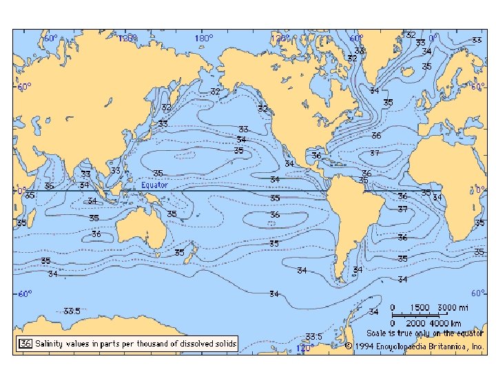

Seawater • In areas where evaporation is far greater than precipitation, such as the Persian Gulf or Red Sea, the salinity levels may exceed 40%. In contrast, areas which are supplied by a lot of fresh water via rivers or precipitation, such as the Baltic Sea, the salinity level is often below 2%. • Generally, the salinity levels of the open ocean range from 3. 3% to 3. 7%. • The lowest salinity often occurs where large rivers empty into the oceans, creating areas of water called estuaries.

Sources and Removal of Sea Salts • What is the primary source of the salt in the sea? The chemical weathering of the rocks on the continent is delivered to the oceans by streams and rivers at an estimated 2. 5 billion tons annually. • Although, rivers continually add salts to the oceans, the salinity of seawater is not increasing. This is because the salts are being removed just as quickly as they are being added. • Water evaporates from seawater and leaves solid salt behind. • Marine organisms remove ions from seawater to build shells, bones, and teeth. As organisms die, their solid parts accumulate on the seafloor and become part of the bottom sediments. • Winds can also pick up salty droplets from breaking waves and deposit the salt further inland.

Physical Properties of Seawater Density • Freshwater has a maximum density of 1. 0 g/cm 3. Because salt ions add to the overall mass of the water in which they are dissolved, they increase the density of the water. • Seawater is more dense than freshwater, and its density increases with salinity. • Temperature also affects density - cold water is more dense than warm water. Because of salinity and temperature variations, the density of seawater ranges from 1. 02 g/cm 3 to 1. 03 g/cm 3.

Physical Properties of Seawater – Freezing Point • Variations in salinity cause the freezing point of seawater to be somewhat lower than that of freshwater. Freshwater freezes at 0°C. • Because salt ions interfere with the formation of the crystal structure of ice, the freezing point of seawater is -2°C.

Physical Properties of Seawater – Absorption of Light • Light only penetrates the upper 100 m of seawater. Below that depth, everything is dark. • Although some fading blue light can reach depths of a few hundred meters, light sufficient for photosynthesis exists only in the top 100 m of the ocean.

Physical Properties of Seawater – Absorption of Light • In the darkness of the deep ocean, some organisms including some fish, shrimp, and crab, are blind. • Other organisms attract prey by producing light, called bioluminescence, through a chemical reaction.

Ocean Layering • Ocean surface temperatures range from -2°C in polar waters to 30°C in equatorial regions, with the average surface temperature being 15°C. • Ocean water temperatures, however, decrease significantly with depth. • Deep ocean water is always cold, even in tropical oceans. It ranges from 0°C to 3°C.

Ocean Layering • Beneath roughly 100 m, temperatures decrease continuously with depth to around 4°C at 1000 m. The dark waters below 1000 m have fairly uniform temperatures of less than 4°C.

Ocean Layering • Based on these temperature variations, the ocean can be divided into three layers. • The first is a relatively warm, sunlit surface layer approximately 100 m thick. • The second is a transitional layer known as thermocline, which is characterized by rapidly decreasing temperatures with depth. • The third layer is a cold and dark bottom layer with temperatures near freezing. • In general, ocean layering is caused by density differences. Because cold water is more dense than warm water, cold water sinks to the bottom, while less-dense, warm water is found near the ocean’s surface.

Tides • Tides are the periodic rise and fall of sea level. • The highest level to which water regularly rises is known as high tide, and the lowest level is called low tide. • Because of differences in topography and latitude, the tidal range – the difference in height between high tide and low tide – varies from place to place. • Generally, a daily cycle of high and low tides takes 24 hours and 50 minutes.
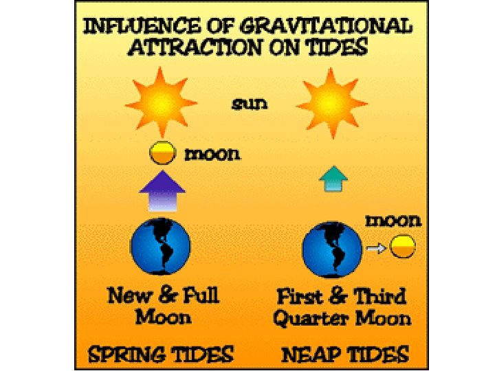

The Moon’s Influence • The basic causes of tides are the gravitational attraction among Earth, the Moon, and the Sun, as well as the Earth’s rotation. • Both Earth and the Moon orbit a common center of gravity. As a result of their motions, both experience differing gravitational forces. • These unbalanced forces generate tidal bulges on opposite sides of Earth.

The Sun’s Influence • The gravitational attraction between Earth and the Sun, and Earth’s orbital motion around the Sun influences tides. • However, even though the Moon is much smaller than the Sun, lunar tides are more than twice as high as those caused by the Sun because the Moon is much closer to Earth. • Consequently, Earth’s tidal bulges are aligned with the Moon.

Surface Currents • Surface currents are the wind driven movement of ocean water that primarily affects the upper few hundred meters of the ocean. • Only the top 100 to 200 m of the ocean experience surface currents, which can move at a velocity of about 100 km per day. • Surface currents follow predictable patterns and are driven by Earth’s three global wind systems: polar easterlies, prevailing westerlies, and trade winds.

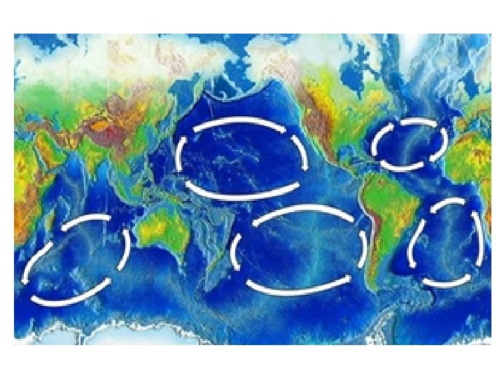
Gyres • Because the continents deflect ocean currents to the north and south, gyres develop. • There are 5 major gyres. • Warm waters enter the polar regions, are deflected by land masses, move back to the equator, and result in cold currents moving to the tropical regions.

Upwelling • In addition to moving horizontally, ocean water moves vertically. The upward motion of ocean water is called upwelling. • Upwelling waters originate in deeper waters, below thermocline, and thus are usually cold. Areas of upwelling exist mainly off the western coasts of continents in the trade wind belts. • Winds blowing from the north cause surface water to begin moving. The Coriolis effect acts on the moving water, deflecting it to the right of its direction of movement, which results in surface water being moved offshore. The surface water is then replaced by upwelling deep water.

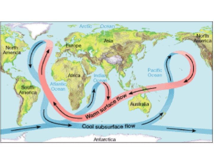
Density Currents • Density currents are a result of differences in temperature and salinity in ocean water. • They move slowly in deep ocean waters, following a general path sometimes called the global conveyor belt. • After hundreds of years, the deep ocean water of density currents returns to the surface through upwelling.
- Slides: 40