Chapter 1 Thinking Geographically What is Human Geography


")


- Slides: 14
Chapter 1: Thinking Geographically
What is Human Geography?
Definitions - Use Cornell • Literal Definition: a description of the earth • Emmanuel Kant: “History looks at change across time. Geography looks at change across space. ” • Hartshorn: “Geography is the discipline that seeks to describe and interpret the variable character from place to place of the earth as the world of man. ” • Greenland: “Geography is the study of the distribution and interrelationships of the elements of the human environment and the relationships between humans and the physical environment. ” • Your Definition:
5 Themes of Geography Location: Where is it located? Absolute location and relative location Place: What’s it like there? Physical and Human characteristics Human/Environment Interaction: What is the relationship between humans and their environment? Human dependence on the environment and Human modification of the environment. Movement: How and why are places connected with one another? Places are shaped by constant movement of people, ideas, materials, etc. Regions: How and why is one area similar to another? Areas that have unifying characteristics.
Spatial Thinking (Phil Gersmehl, Research in Geographic Education, 2006)
Geographic Investigation Process - 4 Level Analysis • Level 1 - What? Where? When? Scale? • Level 2 - Pattern Identification • Level 3 • Why there? • How did it get there? • Level 4 (prediction) • So what? • What if? • Impacts? Effects?
Earth at Night - Global Scale
North America at Night - Regional Scale Online: 6/27/2006 - http: //www. nasa. gov/images/content/49261 main_usa_nightm. jpe
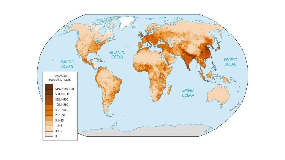
MAPS The tool of the geographer.
These mushroom spores are too small to see, so we put them under a MICROSCOPE. When we can see them, we can begin to study them.
This planet is too big to see, so we put it under a MACROSCOPE. When we can see it, we can study it.
Some things are very tiny, and we must use complex electric and optical means to enlarge them so as to understand their configuration and structural relationships. In contrast, geographical things are so extensive that we must somehow reduce them to bring them into view. - Arthur Robinson, cartographer MAPS are the macroscope.
Uses of Maps • Cartography: The science of making maps. • Reference Tools • To find locations • To find one’s way • Communication Tools • Show the distribution of human & physical features