Channel Islands National Marine Sanctuary Advancing the Science


 www. ecology. uq. edu. au/marxan. htm Developed by")
 • Develops a portfolio of reserve designs that meet")


- Slides: 16
Channel Islands National Marine Sanctuary: Advancing the Science and Policy of Marine Protected Areas Satie Airame Channel Islands National Marine Sanctuary Santa Barbara, California February 2004
Point Conception Santa Barbara Oregonian Bioregion Area of Detail Sanctuary Boundary State Boundary Santa Cruz Island San Miguel I. Santa Rosa Island Californian Bioregion Anacapa I. Santa Barbara Island LEGEND State Boundary Sanctuary Boundary State Marine Protected Areas State Marine Reserve State Marine Conservation Area 0 10 20 30 Kilometers Transition Zone Effective April 9, 2003
Geospatial Tools for Analysis MARXAN (SPEXAN) www. ecology. uq. edu. au/marxan. htm Developed by S. Andelman, I. Ball, F. Davis, D. Stoms National Center for Ecological Analysis and Synthesis Santa Barbara, California Site Selection Module developed by I. Ball and H. Possingham University of Adelaide, Australia Channel Islands Spatial Support and Analysis Tool (CI-SSAT) www. csc. noaa. gov/pagis Developed by NOAA’s Coastal Services Center
Developing Reserve Designs MARXAN (SPEXAN) • Develops a portfolio of reserve designs that meet particular targets. • Uses simulated annealing to develop a large number of alternative designs. • Attempts to minimize the total cost (boundary length) of the reserve network. • Allows the analyst to control the spatial configuration of the reserve designs.
Targets Biogeographic Regions Habitats Species of Special Concern Human and Natural Threats Existing Monitoring Sites
Connectivity BM = 0. 0 BM = 0. 2 BM = 1. 0
Network Size 30% 40% 50%
Network Options Option 1 Option 2 Option 3
Conservation Value Anacapa I. Santa Cruz I. Santa Rosa I. San Miguel I. Santa Barbara I.
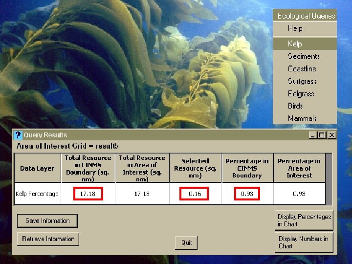
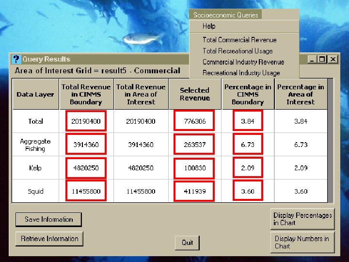
Spatial Support and Analysis Tool • • Visualize Query Design Analyze Shoreline Depth Sediments Kelp Conservation Value Commercial Fisheries Recreational Fisheries Non-consumptive Recreational Activities Personal knowledge Options
Design/Query Option 1 Option 2 Option 3
Alternative 1: Marine Protected Area Network For the Channel Islands National Marine Sanctuary Boundary Californian Bioregion State Boundary San Miguel I. Santa Rosa Island Oregonian Bioregion Santa Cruz Island Transition Zone Anacapa Island Santa Barbara Island
Alternative 4: Marine Protected Area Network For the Channel Islands National Marine Sanctuary Boundary Californian Bioregion State Boundary San Miguel I. Santa Rosa Island Oregonian Bioregion Santa Cruz Island Transition Zone Anacapa Island Santa Barbara Island
Point Conception Santa Barbara Oregonian Bioregion Area of Detail Sanctuary Boundary State Boundary Santa Cruz Island San Miguel I. Santa Rosa Island Californian Bioregion Anacapa I. Santa Barbara Island LEGEND State Boundary Sanctuary Boundary State Marine Protected Areas State Marine Reserve State Marine Conservation Area 0 10 20 30 Kilometers Transition Zone Effective April 9, 2003