Ch 16 Aviation Weather Resources Ch 16 Aviation


 – expected VMC, clouds")


 –")
 – describes conditions which can")


 – describes convective activity")
 – describes convective activity")


 – issued for significant weather")


 • A Transcribed")

 –")


 – an unscheduled")


 – VFR conditions")


 – The")


 – an")


")

 –")


- Slides: 92
Ch 16 – Aviation Weather Resources
Ch 16 – Aviation Weather Resources • Section A – The Weather Forecasting Process – Collecting Weather Data – Processing Weather Data – Making the Forecast • Forecasting Methods • Forecasting Accuracy
Ch 16 – Aviation Weather Resources • Section B – Aviation Weather Forecast Products – Forecast Products in Text Format • Terminal Aerodrome Forecast (TAF) • Area Forecast (FA) • In-flight Weather Advisories (WS, WST, WA) • Transcribed Weather Broadcasts (TWEB) • Winds and Temperatures Aloft Forecast (FD) • Other Advisories, Watches, and Warnings
Ch 16 – Aviation Weather Resources – Forecast Products in Graphic Format • Significant Weather Prognostic Chart • Forecast Winds and Temperatures Aloft Chart
Ch 16 – Aviation Weather Resources • Section C – Aviation Weather Information Sources – FAA Flight Service Stations (FSS) – Continuous Broadcasts of Weather Information (TWEB, HIWAS) – Other Weather Information Sources – Weather on the Internet
Ch 16 – Aviation Weather Resources • Weather information and forecasts are beneficial in numerous ways – Prediction of warm temperatures or the change of rain helps us decide whether to plan a picnic or carry an umbrella for the day – Forecasts of severe weather such as blizzards, thunderstorms, or hurricanes help communities prevent property damage and save lives
Ch 16 – Aviation Weather Resources • As a pilot, weather influences your life in a unique way – Determinations regarding weather conditions must be made before every flight, and crucial weather decisions may have to be made inflight
Ch 16 – Aviation Weather Resources • A wide variety of weather resources are available to assist you in this decision-making process – We describe the on-going process of collecting, transmitting, and processing weather data to produce a weather forecast – We then consider various formats of aviation weather forecasts, and the sources of aviation weather information
Ch 16 – Aviation Weather Resources • When you complete Chapter 16, you should • understand how weather information is compiled and processed, and some basic concepts of forecasting You should also be familiar with the variety of aviation weather forecasts available to you, as well as the sources of aviation weather information to help you make safe preflight and in-flight decisions
Ch 16 – Aviation Weather Resources • Section A: The Weather Forecasting Process – There are three important steps in the forecasting process: data collection, data processing and forecasting • Collecting Weather Data – The World Meteorological Organization (WMO), a United Nations agency is responsible for the standardization of observations and the international exchange of weather data
Ch 16 – Aviation Weather Resources • Processing Weather Data – The National Weather Service (NWS), a part of the National Oceanic and Atmospheric Administration (NOAA), is the U. S. government agency that is primarily responsible for gathering and processing meteorological data and for providing weather forecasts and warnings
Ch 16 – Aviation Weather Resources – These continuing and complicated tasks are conducted by several NWS offices including the National Centers for Environmental Protection (NCEP) and local Weather Forecast Offices (WFO) – One of the components of the NCEP is the Aviation Weather Center (AWC) which specializes in the preparation of aviation weather information
Ch 16 – Aviation Weather Resources • Forecasting Methods – The most comprehensive forecast technique today is numerical weather prediction (NWP) which solves a set of mathematical equations (a numerical model) to predict the weather
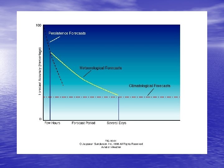
Ch 16 – Aviation Weather Resources • Forecasting Accuracy – In comparison to persistence forecasts, the accuracy of meteorological forecasts, which are based on scientific knowledge as used by NWP and weather forecasters, is much better and decreases much more slowly as the forecast period increases
Ch 16 – Aviation Weather Resources – However, for the longest forecast periods, the accuracy of meteorological forecasts is no better than that of climatological forecasts, which are based purely on past averages and are typically not very accurate at all
Ch 16 – Aviation Weather Resources – Forecasting the weather is somewhat chaotic, which is not too far from the mark. As applied to weather forecasting, chaos theory describes the potential difficulty in making forecasts for long periods of time – The science of chaos began in the early 1960 s with a mathematician and atmospheric scientist named Edward Lorenz and his exploration of computer forecasts
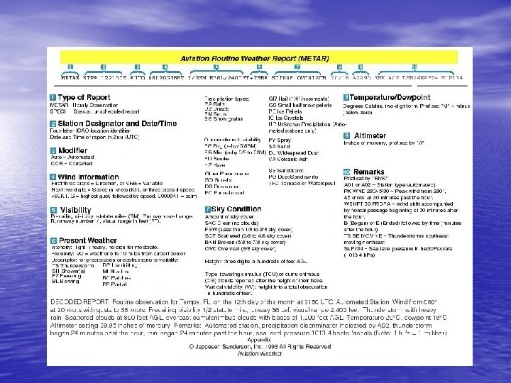
Ch 16 – Aviation Weather Resources • Section B: Aviation Weather Forecast Products – Decoding keys for aviation weather forecast products are included in Appendix D – In addition, FAA Advisory Circular 00 -45 Aviation Weather Services contains further information
Ch 16 – Aviation Weather Resources – Selectivity – requires that you know exactly what you need, what is available and where and when it is available – Visualization – forming a mental image of current and forecast weather conditions
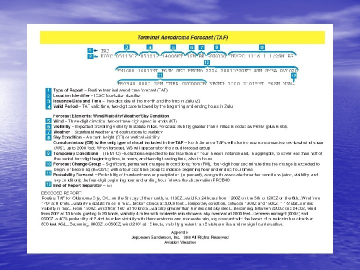
Ch 16 – Aviation Weather Resources • Forecast Products in Text Format – Forecast products in text format include: • Terminal Aerodrome Forecasts (TAF) – describes weather conditions that are expected to occur within a 5 nm radius of an airport over a 24 hour period.
Ch 16 – Aviation Weather Resources – In the US routine TAFs are issued 4 times daily at 0000 Z, 0600 Z, 1200 Z, and 1800 Z. – The TAF is one of the most valuable sources for the predicted weather at a specific airport. – Predicted sky condition, visibility, weather and obstructions to vision, wind direction and speed, and expected changes during the forecast period can be derived from TAFs.
Ch 16 – Aviation Weather Resources • Area Forecasts (FA) – expected VMC, clouds and general weather conditions over an area the size of several states are described in an Area Forecast (FA). – An FA is used to determine en-route weather, including conditions at airports that do not have terminal forecasts.
Ch 16 – Aviation Weather Resources – An FA should always be used in conjunction with the most recent inflight weather advisories. – Area forecasts are normally issued three times daily and are valid for 18 hours.
Ch 16 – Aviation Weather Resources – An FA has four sections: v Header – describes the source of the FA, the date and time of issue, the valid times and the areas the FA covers v Precautionary Statements – describe IFR and mountain obscurations, thunderstorm hazards, and states that all heights are MSL unless otherwise noted
Ch 16 – Aviation Weather Resources v. Synopsis – a brief summary identifying the location and movement of pressure systems, fronts, and circulation patterns for the 18 hour forecast period. v. VFR Clouds and Weather – this section lists expected sky condition, visibility and weather for the next 12 hours and an outlook for the following 6 hours
Ch 16 – Aviation Weather Resources – Area forecasts are issued by the Aviation Weather Center (AWC) for the six regions in the contiguous US. v. The Alaskan Aviation Weather Unit issues an FA for the state of Alaska while the Honolulu WFO handles Hawaii. v. Special FAs are also issued for the Gulf of Mexico and international airspace
Ch 16 – Aviation Weather Resources – Within its prescribed area, an FA describes weather features and conditions relative to common geographical regions and features
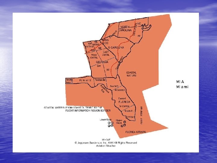
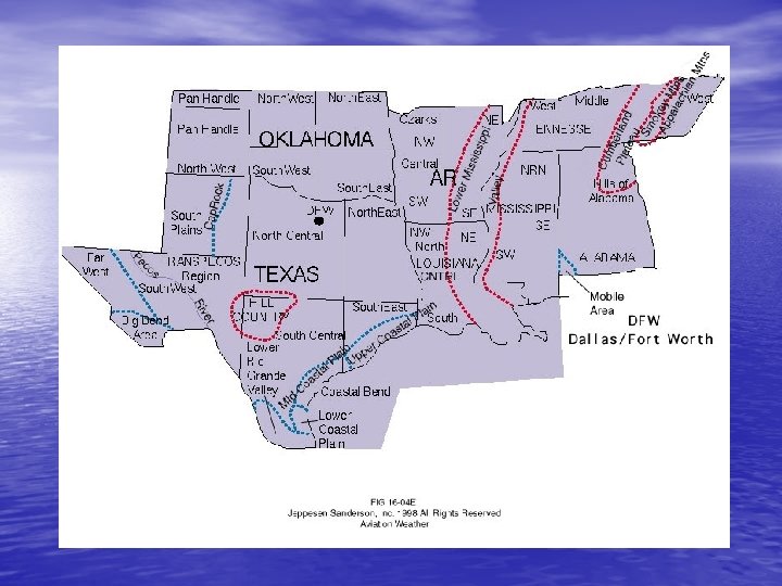
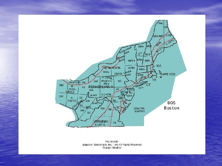
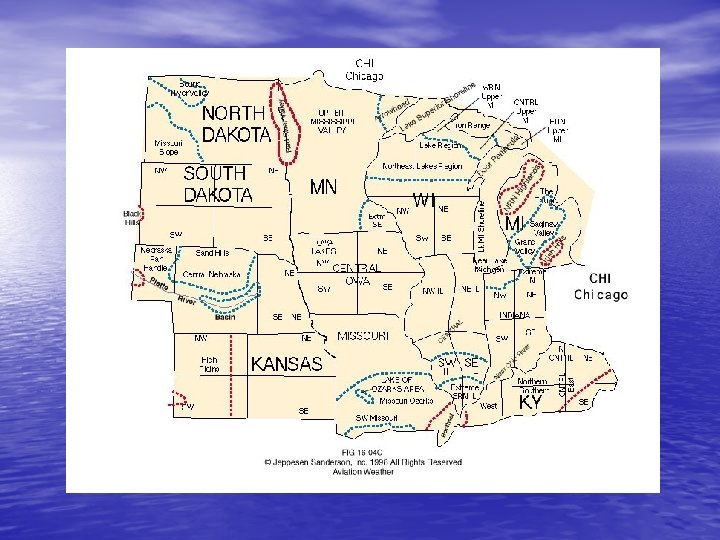
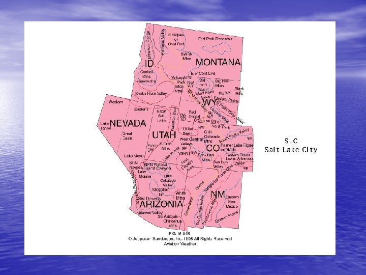
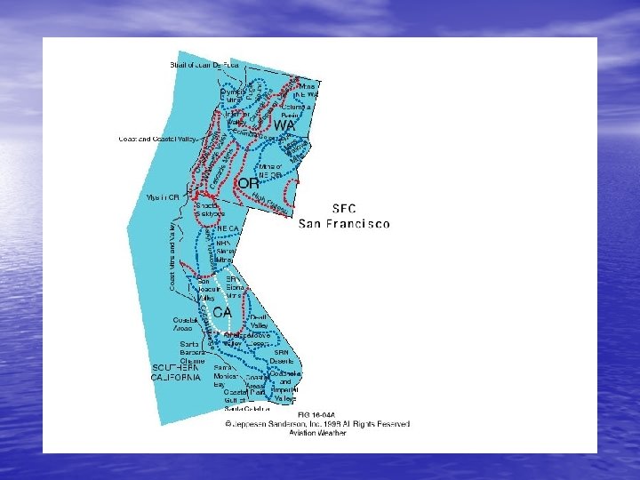
Ch 16 – Aviation Weather Resources – The contiguous US is divided into 6 forecast areas v. SFO – San Francisco v. SLC – Salt Lake City v. DFW – Dallas / Fort Worth v. CHI – Chicago v. BOS – Boston v. MIA – Miami
Ch 16 – Aviation Weather Resources • ***The area forecast covers an area of several states and can be used to determine en-route weather and conditions at your destination if no TAF has been issued
Ch 16 – Aviation Weather Resources • The geographical area designator map can be useful in determining the specific area described by an area forecast – The contiguous US is divided into six forecast areas (colored area) – You may want to keep a copy of this map with your flight planning materials so that you have access to it when you obtain weather information.
Ch 16 – Aviation Weather Resources • The accuracy of weather forecasts as a function of the forecast period and the forecasting method – Comparison of the accuracy of persistence, meteorological, and climatological forecasts forecast periods from a few hours to several days – Very general
Ch 16 – Aviation Weather Resources – The actual rate of deterioration of the accuracy of forecasts for a given airport depends on its location, the season, and the forecast variable.
Ch 16 – Aviation Weather Resources • In-flight Weather Advisories (WS, WST, WA) – consist of either an observation and a forecast, or just a forecast for the development of potentially hazardous weather
Ch 16 – Aviation Weather Resources – SIGMET (WS) – describes conditions which can pose hazards to all aircraft. • SIGMETs are valid for up to four hours.
Ch 16 – Aviation Weather Resources • If the following phenomena are observed or expected to occur, a SIGMET is issued – 1. Severe icing not associated with thunderstorms – 2. Severe or extreme turbulence or clear air turbulence not associated with thunderstorms – 3. Dust storms or sandstorms lowering surface or in-flight visibilities to below three miles – 4. Volcanic ash
Ch 16 – Aviation Weather Resources • ***SIGMETs are issued as warnings of hazardous weather, such as severe icing, which is of operational interest to all aircraft
Ch 16 – Aviation Weather Resources – Convective SIGMETs (WST) – describes convective activity that is potentially hazardous to all categories of aircraft
Ch 16 – Aviation Weather Resources • Convective SIGMETs (WST) – describes convective activity that is potentially hazardous to all categories of aircraft – Bulletins are issued hourly with special advisories issued as required – The forecast period for a WST is two hours or less – Criteria for issuance are any of the following conditions
Ch 16 – Aviation Weather Resources – Severe thunderstorms (surface winds greater than or equal to 50 knots and/or hail at the surface greater than or equal to ¾ inches in diameter and/or tornadoes) – Embedded thunderstorms – A line of thunderstorms
Ch 16 – Aviation Weather Resources – Thunderstorms producing precipitation with an intensity greater than or equal to heavy and affecting 40% or more of an area at least 3, 000 square miles
Ch 16 – Aviation Weather Resources – Convective SIGMET bulletins are issued for the Eastern (E), Central (C), and Western (W) United States – Convective SIGMET text is presented in figure 16 -7
Ch 16 – Aviation Weather Resources • AIRMET (WA) – issued for significant weather at intensities lower than those required for the issuance of a SIGMET – Although AIRMETs are of operational interest to all aircraft, the weather conditions specified are particularly hazardous to light aircraft having limited capability or minimal equipment and instrumentation
Ch 16 – Aviation Weather Resources – There are three different AIRMETs • AIRMET Sierra – describes IFR conditions and/or extensive mountain obscurations • AIRMET Tango – describes areas of moderate turbulence, sustained surface winds in excess of 30 knots and areas of non-convective low-level wind shear • AIRMET Zulu – describes moderate icing and provides freezing level heights
Ch 16 – Aviation Weather Resources – Pilots with limited experience or qualifications should pay special attention to these advisories
Ch 16 – Aviation Weather Resources – AIRMETs are issued every six hours with unscheduled updates and corrections issued as necessary – Each bulletin contains any current AIRMETs that are in effect, an outlook for weather that is expected after the AIRMET valid period any significant conditions that do not meet AIRMET criteria – Examples of AIRMETs Sierra, Tango and Zulu are given in figure 16 -8
Ch 16 – Aviation Weather Resources • ***Weather conditions that are particularly hazardous to small, singleengine aircraft are contained in an AIRMET
Ch 16 – Aviation Weather Resources – AIRMETs and SIGMETs are issued for the 6 regions corresponding to the FA areas – These widespread advisories must be either affecting or forecasted to affect at least 3, 000 square miles at any one time – International SIGMETs are issued worldwide by ICAO Meteorological Watch Offices (MWOs); see figure 16 -9
Ch 16 – Aviation Weather Resources – The criteria for International SIGMETs are broader than the criteria for either WS or WST for the US • Thunderstorms in lines, embedded in clouds, or in large areas producing tornadoes or large hail • Tropical cyclones • Severe icing • Severe or extreme turbulence • Dust storms or sand storms lowering visibility to less than 3 miles (5 km) • Volcanic Ash
Ch 16 – Aviation Weather Resources – Transcribed Weather Broadcasts (TWEB) • A Transcribed Weather Broadcasts (TWEB) is a synopsis and forecast for a 50 -mile-wide corridor along a specific flight route or within 50 nm of the FSS • TWEBs are prepared for more than 200 flight routes and local vicinities around the US
Ch 16 – Aviation Weather Resources • TWEB forecasts are valid for 12 hours • They are updated 4 times daily • TWEBs do not include areas of icing and turbulence • TWEB example given in figure 16 -10
Ch 16 – Aviation Weather Resources • Winds and Temperatures Aloft Forecasts (FD) – FDs furnish a prediction of wind speed (knots), wind direction (degrees True), and temperature (degrees C) for selected altitudes at specific locations across the US, including Alaska, Hawaii and over some US coastal waters – Figure 16 -11 gives the distribution of forecast stations – Winds and temperatures aloft contain wind direction in relation to true north, wind speed in knots and temperature in degrees Celsius for a range of altitudes
Ch 16 – Aviation Weather Resources – FDs wind speeds between 100 and 199 knots are encoded so direction and speed can be represented by four digits – These winds are decoded by subtracting 50 from the two digit wind direction and adding 100 to the wind speed – The negative sign for temperatures above 24, 000 feet MSL is not included – A wind code of 9900 is interpreted as light and variable – Forecast winds greater than or equal to 199 knots are reported as 199 knots
Ch 16 – Aviation Weather Resources • Other Advisories, Watches, and Warnings – Center Weather Service Unit (CWSU) – operated by NWS meteorologists within the confines of each ARTCC – Meteorological impact statements (MIS) / center weather advisories (CWA) – produced by the CWSU of each ARTCC – Hurricane advisories (WH) – issued to alert the aviation community to the presence of a hurricane located at least 300 nm offshore and threatening the coastline
Ch 16 – Aviation Weather Resources – Severe watch bulletin (WW) – an unscheduled message that defines areas of possible severe thunderstorms or tornado activity – Severe watch alert (AWW) – a preliminary notice to alert forecasters, briefers and pilots that WW is being issued – Severe thunderstorm warnings / tornado warnings – public notifications that those phenomena have been sighted visually or by radar – Convective outlook (AC) – SPC also produces a convective outlook (AC) for the occurrence of thunderstorms (non-severe and severe) five times a day for the next 24 hours (day 1 convective outlook) and twice a day for the following 24 hours (day 2 convective outlook)
Ch 16 – Aviation Weather Resources • Forecast Products in Graphic Format – Descriptions of examples of all common forecast and analysis graphics are given in Appendix D
Ch 16 – Aviation Weather Resources • Significant Weather Prognostic Chart – The significant weather prognostic chart can be used to determine areas to avoid, such as forecast locations of low visibilities or turbulence – See figure 16 -13 – Lower left hand corner of each panel gives the valid times for the forecast – The surface prog in the lower panel uses standard symbols to depict fronts, isobars, pressure centers and areas of forecast precipitation
Ch 16 – Aviation Weather Resources – Regions of continuous precipitation and unstable showery precipitation are within a solid green line with hatching – Intermittent precipitation is only enclosed with a solid green line – The upper panel portrays forecast areas of IFR (solid red lines)
Ch 16 – Aviation Weather Resources – MVFR (scalloped green lines) – VFR conditions – Areas and layers of expected moderate or greater turbulence are enclosed with dashed yellow lines – The highest freezing level (dashed green lines) and the intersection of the freezing level with the surface are also shown
Ch 16 – Aviation Weather Resources • High-level significant weather prog chart – Covers the airspace from 25, 000 feet to 60, 000 feet pressure altitude – Charts from some world area forecast centers (WAFC) cover the layer from FL 240 to FL 630 – A wide range of information can be interpreted from this chart including forecast of thunderstorm areas, tropical cyclones, surface positions of well-defined convergence zones, movement of frontal systems and the locations and speeds of jetstreams; see figure 16 -14 – The positions of jet streams with speeds greater than 80 knots are indicated by long, heavy lines with arrowheads showing the direction of flow
Ch 16 – Aviation Weather Resources – Each jet is labeled with altitude; speed and direction of the maximum wind in the jet core is shown with conventional wind barbs – Heights of the tropopause are indicated in boxes; relatively high and low tropopause heights are indicated with H and L respectively – Areas of significant CB (thunderstorm) activity are enclosed in scallooed lines with heights of tops and bases indicated
Ch 16 – Aviation Weather Resources – If the base of the layer is below 25, 000 feet it is indicated by xxx – These areas include CB embedded in clouds, haze, or dust – Areas of moderate and greater turbulence are enclosed in dashed lines – Predicted intensities and heights of bases and tops of the turbulent layers are also given – The high-level significant weather prog chart also includes positions of surface fronts, squall lines and the location of volcanic eruptions; see Appendix D for more details
Ch 16 – Aviation Weather Resources • Forecast Winds and Temperatures Aloft Chart – The third forecast graphic that is useful for flight planning is the forecast winds and temperatures aloft chart – This is simply a graphical presentation of the information given in FD forecast bulletins
Ch 16 – Aviation Weather Resources – See figure 16 -15 for a sample FD chart for international flights – Wind and temperature predictions are produced at regularly spaced latitude and longitude positions on international charts – Other useful forecast charts include the convective outlook chart and the volcanic ash forecast transport and dispersion (VAFTAD) chart
Ch 16 – Aviation Weather Resources • Section C: Aviation Weather Information Sources
Ch 16 – Aviation Weather Resources • FAA Flight Service Stations (FSS) – The flight service station (FSS) is one of the most common sources of weather information for pilots – Automated flight service stations (AFSS) – about one per state; these are the result of consolidating older, manual stations – More aviation weather briefing services are provided by FAA flight service stations than any other government service
Ch 16 – Aviation Weather Resources – A standard briefing – provides you with the most complete weather picture tailored to your specific flight; figure 16 -16 lists the items included in a standard briefing – For a telephone briefing it is helpful to have examined these data ahead of time – An abbreviated briefing – enables you to supplement mass disseminated data, update a previous briefing, or request specific information – If your proposed departure time is six or more hours in the future an outlook briefing provides a general overview of forecasted weather
Ch 16 – Aviation Weather Resources – The most common method of obtaining weather information from an FSS is a briefing over the telephone – You can obtain one of three types of briefings: standard, abbreviated and outlook – An FSS briefing can be obtained by dialing 1800 -WX-BRIEF
Ch 16 – Aviation Weather Resources • ***You should request a standard briefing if you have received no preliminary weather information and are departing within the hour. – To supplement mass disseminated data, an abbreviated briefing should be requested. – The FSS provides an outlook briefing 6 or more hours in advance of your proposed departure time
Ch 16 – Aviation Weather Resources – Transcribed information briefing service (TIBS) – an AFSS service that provides continuous telephone recordings of meteorological and/or aeronautical information 24 hours a day – TIBS provides route briefings and depending on user demand aviation weather observations, forecasts and wind and temperature aloft forecasts – TIBS information is frequently updated to ensure current and accurate weather data
Ch 16 – Aviation Weather Resources – Local numbers for TIBS are available in the AFD (Airport Facility Directory) – En route flight advisory service (EFAS) – probably the most familiar inflight service to pilots – To use this service contact the specific EFAS by using the words “Flight Watch”
Ch 16 – Aviation Weather Resources – The frequency for flight watch below 18, 000 feet MSL is 122. 0 MHz – Upon your request, the flight watch specialist can provide aviation weather information and time-critical enroute assistance – If you are facing hazardous or unknown weather conditions, EFAS may recommend alternate or diversionary routes – The receipt and rapid dissemination of pilot weather reports is a primary responsibility of EFAS
Ch 16 – Aviation Weather Resources • ***At altitudes below 18, 000 feet, you can contact Flight Watch on 122. 0 MHz for information regarding current weather along your proposed route of flight
Ch 16 – Aviation Weather Resources • Continuous Broadcasts of Weather Information (TWEB, HIWAS) – TWEB is aired continuously • over selected low and medium frequency NDBs (nondirectional beacons) – 190 – 535 k. Hz • and over VORs (very high frequency omni-directional ranges) – 108. 0 – 117. 95 MHz
Ch 16 – Aviation Weather Resources • ***TWEBs contain in-flight cross-country weather information including winds and temperatures aloft forecasts
Ch 16 – Aviation Weather Resources • Hazardous inflight weather advisory service (HIWAS) – another in-flight service that provides a continuous broadcast over selected VORs to inform you of hazardous flying conditions such as turbulence, icing, IFR conditions and high winds
Ch 16 – Aviation Weather Resources • Other Weather Information Sources – Automatic terminal information service (ATIS) – available at most major airports that have operational control towers – ATIS is a pre-recorded report, broadcast on a dedicated frequency which includes information regarding current weather and pertinent local airport conditions – ATIS is normally recorded every hour but may be updated any time
Ch 16 – Aviation Weather Resources – ATIS frequencies are listed in the AFD (Airport Facility Directory) – Direct user access terminal service (DUATS) – The FAA supports the DUATS service – This computer-based program provides NWS and FAA products that are normally used in pilot weather briefings – By using a personal computer and modem you can access weather information prior to flight
Ch 16 – Aviation Weather Resources – Flight plans can also be filed and amended through DUATS – Other weather sources include weather forecasts by local news broadcasts, the Weather Channel, airing on cable television and Jeppesen Data. Plan
Ch 16 – Aviation Weather Resources • Weather on the Internet – The internet is probably one of the fastest growing sources of aviation weather – Appendix F gives a large number of US and international agencies that provide both aviation weather information and general weather information
Ch 16 – Aviation Weather Resources • Summary – This chapter has provided an understanding of the procedures used to collect and process raw weather data, and to make weather forecasts. – The discussion of forecast methods has given you some insight into the accuracy of forecasts
Ch 16 – Aviation Weather Resources – This knowledge should assist you in interpreting and effectively using weather data for flight planning. – In addition, you are now familiar with the essential aviation weather forecast products in both text and graphic formats – You know of a variety of sources from which you can obtain observations and forecasts appropriate for your flying needs
Ch 16 – Aviation Weather Resources • The “standard briefing” is a useful guide in selecting pertinent information – Your knowledge of the three-dimensional structure and behavior of weather systems allows you to integrate available information into a comprehensive picture – This new information will help you practice “selectivity” and “visualization” in dealing with current and forecast flight weather.
Ch 16 – Aviation Weather Resources – A practical application of your knowledge of aviation weather resources is explored in the final chapter