CBRF June 16 Forecast Webinar Please Mute Your

CBRF June 16 Forecast Webinar Please Mute Your Phones: *6 1 pm, June 16, 2011 Kevin Werner These slides: www. cbrfc. noaa. gov/present. php

Outline • Recent and Upcoming Weather Review • Snow States • Streamflow forecasts: – Long Lead Peak – Daily – Water Supply Web Reference: www. cbrfc. noaa. gov/wsup/pub 2/map/html/cbrfc. 1. 2011. html

Web Reference: http: //www. cbrfc. noaa. gov

June 1 -15 Precipitation Web Reference: http: //water. weather. gov/precip

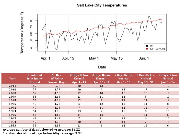
Temperature

Snow June 9 June 16 Web Reference: http: //www. cbrfc. noaa. gov/gmapm. php? scon=checked

June 2 June 9 June 16

120 sites showing highest value for today!!

229 sites with 10+ years of record; 127/229 or 55% of sites with daily record as of 5/31

% average daily % average seasonal peak Melt or accumulation rate Historical years Analogue years
 Web Reference: http: //www. cbrfc. noaa. gov/station/sweplot.")
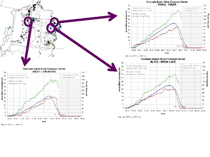
Snow: Upper Green Basin (above Flaming Gorge) Web Reference: http: //www. cbrfc. noaa. gov/station/sweplot. cgi? ? ? open

Snow: Yampa Web Reference: http: //www. cbrfc. noaa. gov/station/sweplot. cgi? ? ? open
 Web Reference: http: //www. cbrfc. noaa. gov/station/sweplot. cgi? ?")
Snow: Colorado Mainstem (above Cameo) Web Reference: http: //www. cbrfc. noaa. gov/station/sweplot. cgi? ? ? open

Snow: Gunnison Basin Web Reference: http: //www. cbrfc. noaa. gov/station/sweplot. cgi? ? ? open

Snow: San Juan Basin Web Reference: http: //www. cbrfc. noaa. gov/station/sweplot. cgi? ? ? open

Snow: Bear River Basin Web Reference: http: //www. cbrfc. noaa. gov/station/sweplot. cgi? ? ? open

Snow: Weber River Basin Web Reference: http: //www. cbrfc. noaa. gov/station/sweplot. cgi? ? ? open

Snow: Duchesne River Basin Web Reference: http: //www. cbrfc. noaa. gov/station/sweplot. cgi? ? ? open

Snow: Six Creeks in Salt Lake County Web Reference: http: //www. cbrfc. noaa. gov/station/sweplot. cgi? ? ? open

Snow Maps Web Reference: http: //www. nohrsc. nws. gov
 Sunday PM Wednesday PM Low Pressure moves in today")
Weather Forecast <- Today (Thursday) Sunday PM Wednesday PM Low Pressure moves in today through weekend bringing cooler temperature Warming by middle of next week

Forecast Precipitation • Showery weather pattern associated with low pressures • Drier next week Web Reference: www. hpc. noaa. gov

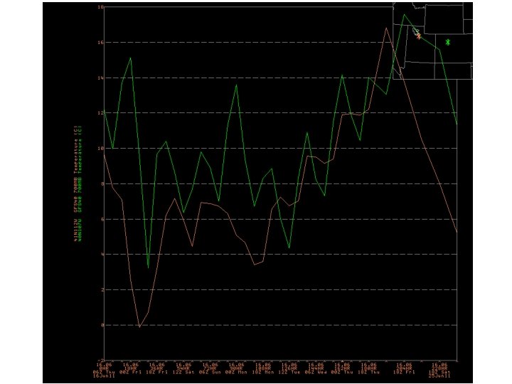
Forecast Temperature

La Nina Web Reference: http: //www. cpc. noaa. gov and iri. columbia. edu/climate/ENSO

Soil Moisture

Peak Flow Forecasts Long Lead Peak Flow Forecasts • Snowmelt Mean Daily Maximum Flow (April-July) • Probabilistic Forecasts Exceedence Probabilities -10%, 25%, 50%, 75%, 90% • Issued (at least) monthly from March-June (this year weekly starting April 19) • ~60 forecast points – some unregulated, some regulated 29 Daily Forecasts • Full Hydrograph out 14 days • Includes temperature (10 days) and precipitation (5 days) forecast • Includes any knowledge of future regulation (e. g. reservoir release) • Single value forecast • Issued daily by 10 am MDT and updated throughout day • ~450 forecast points
 • Runoff characteristics")
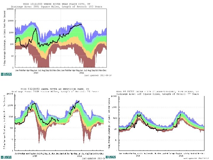
Spring Weather Really Matters (and has mitigated high flows this year) • Runoff characteristics are largely determined by the day-to-day spring weather. – While large snow pack years increase chances for flooding, it is not an inevitability – Small snow pack years (like last year) can flood with the right sequence of spring temperatures

CBRFC Website Mini Tutorial • Current website – Extensive in scope – Slower, cumbersome www. cbrfc. noaa. gov

CBRFC Website Mini Tutorial • “Beta” website – Faster – Easier access to key information – Actively being developed www. cbrfc. noaa. gov/gmap/cmap. php

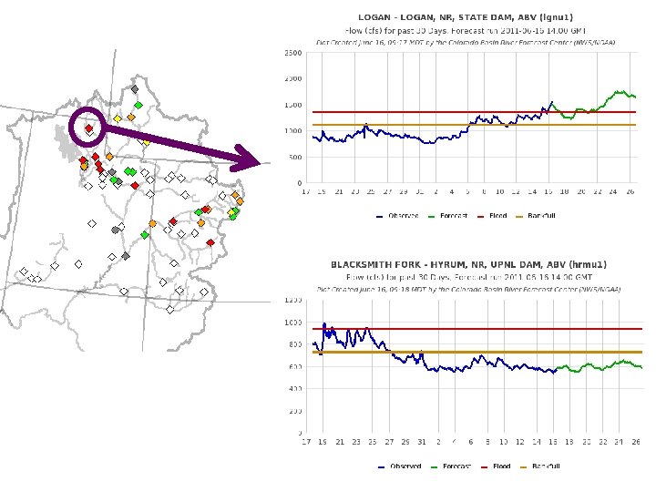
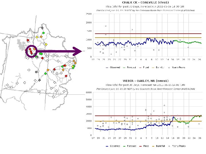
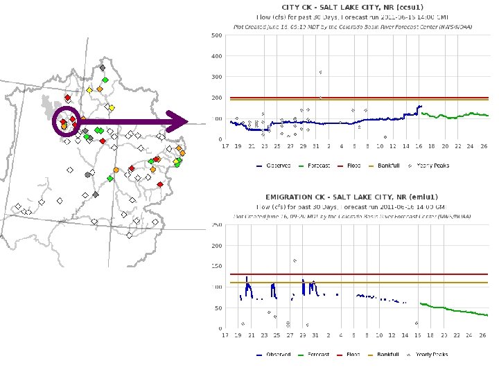
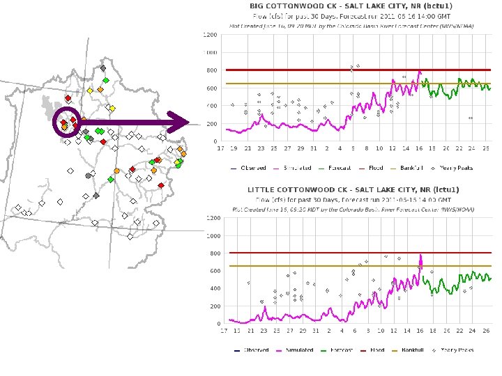
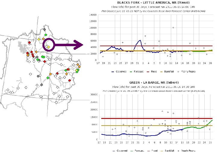
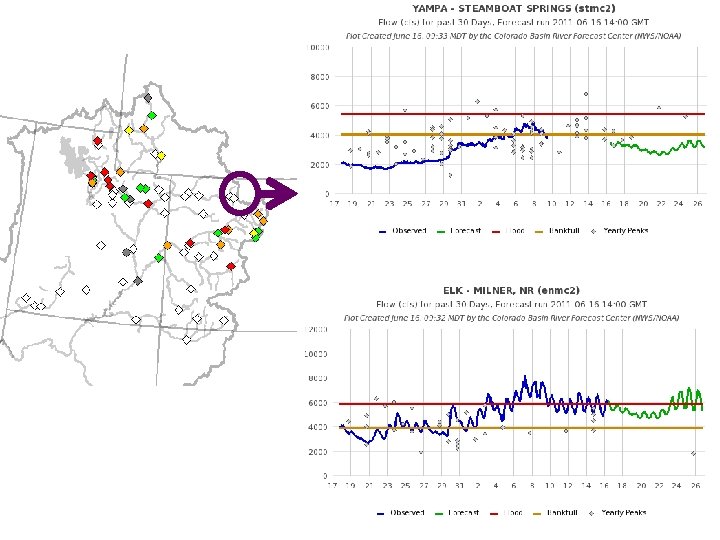
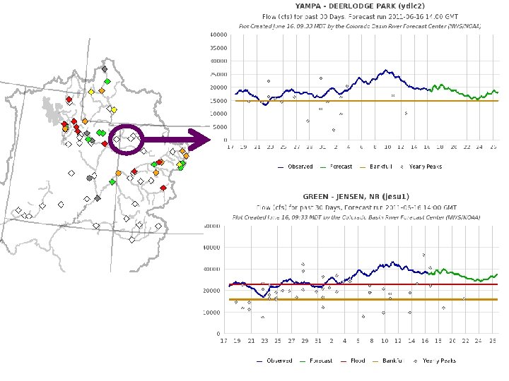
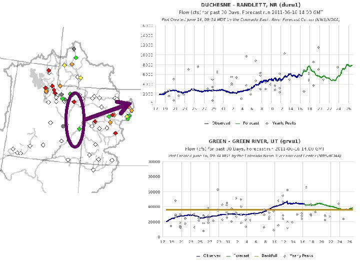
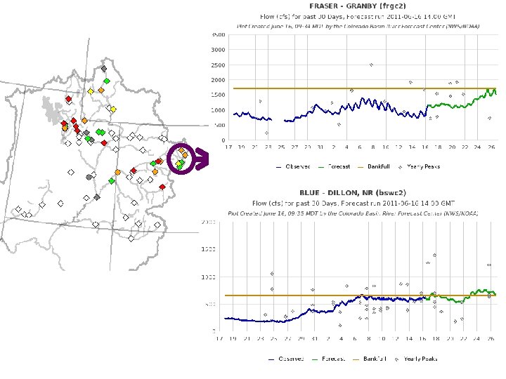
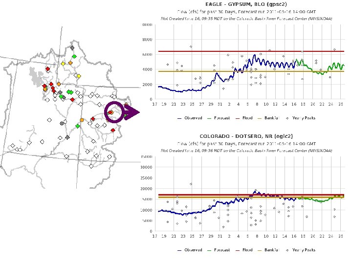
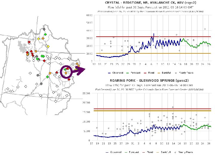
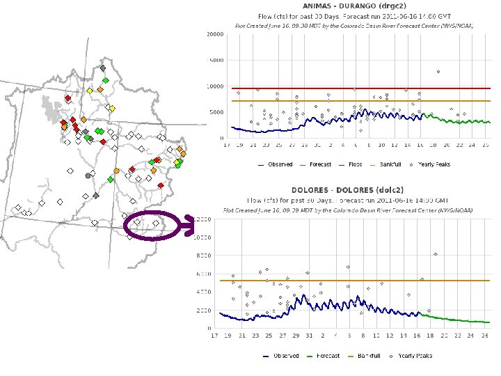
Peak Flow Charts Flood Stage Forecast Creation Time Long lead peak forecast Observed streamflow since April 1 Daily forecast Bankfull web reference: www. cbrfc. noaa. gov/gmap/cmap. php

Current Forecasts May 24 Forecasts June 16 daily Forecasts


Experimental: Peak Flow Forecast Evolution • • Daily long lead peak forecasts from ESP reflect changing weather forecasts and hydrology. Started in late May and comparing to official forecasts Little Cottonwood Creek (top) Yamap near Deerlodge (bottom) • Comments welcome • • Web reference: http: //www. cbrfc. noaa. gov/devel/dly_peak/
 really matter Ensemble forecasts for: • Yampa River • Middle elevation")
Snowpack (and elevation) really matter Ensemble forecasts for: • Yampa River • Middle elevation • Significant melt already occurred • Little Cottonwood Creek • Higher elevation • Most melt forthcoming

Experimental Daily Ensembles Ensemble forecasts that incorporate weather forecasts are run daily for Upper Colorado Basin forecast points Prototype web tool available Does NOT work correctly downstream of reservoirs yet NOT available for the Great Basin yet URL: www. cbrfc. noaa. gov/devel/hefs

NWS Flood Warnings, Watches • NWS Weather Offices are responsible for setting flood stage and issuing flood warnings and watches based on CBRFC forecasts. Key personnel for snow melt floods: – – Salt Lake City – Brian Mc. Inerney Grand Junction – Aldis Strautins Riverton – Jim Fahey Boulder – Treste Huse

Peak Flow Decision Support • Peaks are coming soon!! • Long lead peak forecasts will no longer be updated this year because most rivers are peaking within the 14 -day daily forecast window • Daily forecasts posted by ~10 am MDT each (and updated later during the day). When temperatures are forecast to warm, please check here for the latest peak flow forecasts. • “beta” website developments: – SNOTEL percentiles – Simplified peak flow chart – Publication referencing forecasts above historic peaks – New peak flow forecast points added • Webinars: Weekly until peak flows are passed. Thursday, June 16 at 1 pm • Discussion: – Anything else you need? ?

CBRFC Blog. citizen. apps. gov/cbrfc
 –")
CBRFC Contacts • Basin Focal Points (Available to discuss forecasts: 801. 524. 5130) – – – Upper Colorado: Brenda Alcorn Green: Ashley Nielson San Juan / Gunnison: Tracy Cox Great Basin: Brent Bernard Lower Colorado (below Lake Powell): Greg Smith

Feedback, Questions, Concerns always welcome…. Kevin Werner CBRFC Service Coordination Hydrologist Phone: 801. 524. 5130 Email: kevin. werner@noaa. gov
- Slides: 56