CARTOGRAPHY The science or practice of drawing maps


 • used for")


 • Each parallel")
 and seconds (“) • 1° = 60")


 of Polaris (North Star over North Pole)")


- Slides: 32
CARTOGRAPHY: The science or practice of drawing maps
What are maps? • A map is a representation of an area used to show physical features, exact locations and distances. • the study and making of maps is called cartography. • LAND FORMS eg. mountains, lakes, rivers, etc • MAN MADE STRUCTURES eg. cities, roads, mines
MAKING MAPS: Map Projections • Maps are tricky: Earth is round but paper is flat. • Mapmakers use three different map projections: • Mercator • Gnomonic • Polyconic
Mercator Projection • Shows the whole world (except extreme polar regions) • used for navigation charts, shows true direction as straight lines • BUT distorts (enlarges) areas farther from equator.
Gnomonic Projection • Can only show one hemisphere at a time • Correctly shows shortest route between two points • Used in seismic work because seismic waves tend to travel along great circles. • Used by navy in plotting direction since radio signals travel along great circles.
Polyconic Projection • Projects points and lines from a globe onto a cone. • Cone touches the globe at a particular line of latitude along which there is very little distortion in the areas or shapes. • More ACCURATE • Best for making TOPOGRAPHIC maps • Not good for large areas.
GREAT CIRCLES • Great Circle is any circle that passes through the CENTER • All other circles are small circles. • Great Circles show the shortest route between two points. • Used in airplane travel.
Latitude and Longitude • Show distances and location • Both measured in degrees • Earth is a sphere. There are 360 degrees in a circle, • Any line drawn around the Earth, then, is a circle. • Degrees are divided into minutes(‘) and seconds (“)
Latitude and Longitude • Degrees are subdivided into minutes and seconds • One degree is divided into 60 minutes (60’) • One minute is divided into 60 seconds (60”)
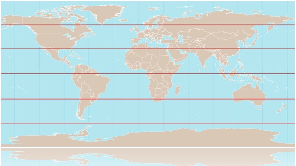
Latitude • Indicates distance North and South • Also called PARALLELS (horizontal lines running East to West) • Never intersect
Latitude • Equator is main reference line of latitude (0 °) • Each parallel measures one degree north or south of the equator. • Poles are at 90 ° • Eg. North Pole is 90 ° N • Eg. South Pole is 90 ° S
Latitude • Degrees are divided into minutes(‘) and seconds (“) • 1° = 60 min • 1 min = 1/60 degree • 1° = 112 km • 111. 699 km
What is the distance in km of 15 degrees?
If one degree = 112 km, then 5 degrees = 560 km
What is the distance in km from equator to North Pole?
North Pole is at 90 °. One degree is 112 km Distance is ~ 10, 000 km
Finding your Latitude • The altitude (angle) of Polaris (North Star over North Pole) is equal to your latitude
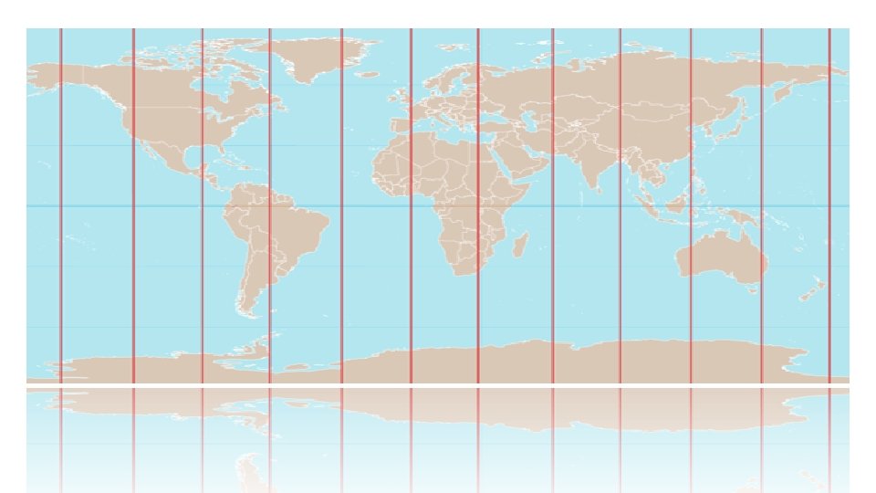
LONGITUDE • Measure distance East and West • Also called MERIDIANS • Measured in degrees • PRIME MERIDIAN (0 ° longitude) is the starting line for the world-wide longitude system, at Greenwich, England. Separates the eastern hemisphere from the western • Halfway around the world, at 180 ° longitude, is the International Date Line.
International Date Line • 180 ° East or West of Prime Meridian
LONGITUDE • No set km for distance, because lines converge at poles. • Example: a city at 30° East near the equator would be farther away from prime meridian than a city at 30° East closer to the pole.
Combine latitude and Longitude to get a coordinate
Latitude and Longitude • Be sure to include direction for both latitude and longitude. • Example Burnaby is located at: • 49° 16’ 2" N • 122° 58' 8" W
What is the location of Tofino? • sd
49° N, 125° W • sd
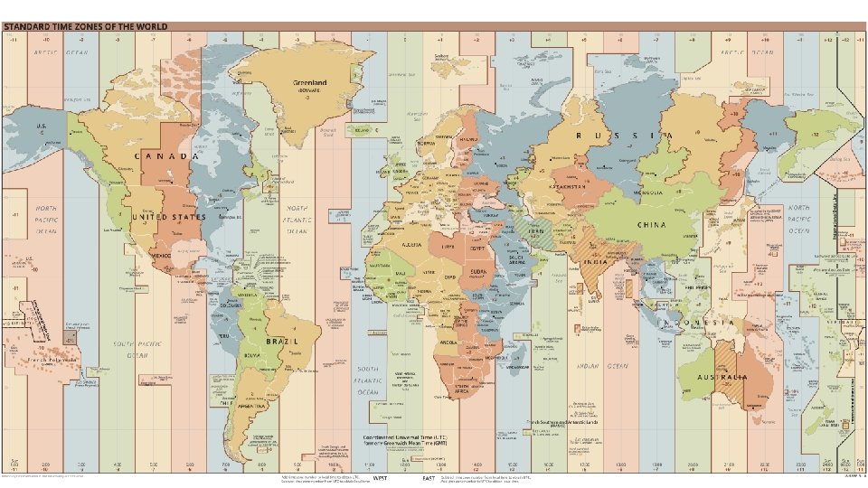
Time Zones • Earth’s rotation is the basis for local time • The Earth rotates 360º in 24 hours • Earth rotates on an imaginary axis at 15º per hour • Earth is divided into 24 (15º) time zones
If you could dig all the way through, what would you hit?
Antipode – direct opposite of something else • Opposite point on Earth from a location • Antipode calculator: https: //www. a ntipodesmap. com/
Calculating Antipode • Latitude: Change North to South • Eg. 49° N becomes 49° S • 180 – longitude = antipode • Eg. 123° becomes (180 -123) = 57°
PRACTICE READING LATITUDE AND LONGITUDE • In class: Complete Latitude and Longitude WS • Read pages. . . 109 -112 textbook