Caribbean Training Course in Seismology and Tsunami Warnings

Caribbean Training Course in Seismology and Tsunami Warnings June 25 -30, 2007, St. Augustine, Trinidad Sea Level Monitoring for Tsunami Confirmation and Forecast Dr. Charles Mc. Creery, Director NOAA Richard H. Hagemeyer Pacific Tsunami Warning Center Ewa Beach, Hawaii USA

Why do we need to monitor the sea level? • Tsunami Warning Operations • Rapid detection of tsunami waves • Rapid evaluation of tsunami strength • Constraint of source forecast model • Tsunami reporting • Determination of the end of the threat • Tsunami Research • Measurements for the historical database • Measurements for model validation

Types of Sea Level Gauges • Coastal Gauges – Lower initial cost – Easier and cheaper to install and maintain – Denser distribution for rapid tsunami confirmation – Must be on a coast with a place to install the gauge – Signals are contaminated by the coast • Deep Ocean Gauges (Buoys and Cable) – Higher initial cost – Difficult and expensive to install and maintain – Can be more strategically positioned – Provide purest tsunami signals that are the best for constraining forecast models

U. S. National Ocean Service Coastal Sea Level Gauges
")
NOS Sea Level Gauges (1 -min samples, 6 -min transmissions)

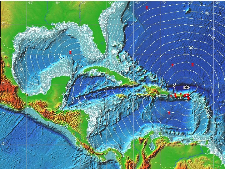
Current Atlantic, Caribbean, and Gulf of Mexico DARTs

Current Atlantic, Caribbean, and Gulf of Mexico DARTs
 FOR A LISBON-TYPE EVENT")
TSUNAMI TRAVEL TIME ISOCRONS (1 -HR) FOR A LISBON-TYPE EVENT

Sample Tide Gauge Formats UHSLC Format – Readable ASCII SWIO 40 RJTD 250015 : ENB 1 #1 M 3908 3910 3909 3911 3909 3912 3910 3913 3917 3915 3918 3914 3917 3912 3913 3912 3913 3911 3908 3905 3909 : ENC 1 #2 3409 3410 3411 3413 3419 3420 3419 3415 3414 3418 3411 3408 3410 3409 3408 3409 3414 3413 3409 3414 3410 3412 3409 3410 3413 : BATTLOAD 0 12. 83 : NAME= NTC Format (Gibberish Format) 91642 46/// /1205 10296 40080 22200 00287 555 77744 A 0102 516`3 60029 6315 B 03024 83030 00 A 07 02548 02901 29631 6 B 090 24520 2400 A 13025 90036 00297 317 B 1 50240 60310 0 A 190 26230 38002 96317 B 2102 37103 100 A 2 50266 50330 02973 18 B 27 02331 02800 A 3102 70103 10029 8318 B 33022 92026 00 A 37 02736 03401 29831 8 B 390 22570 2801 A 43027 66028 00299 319 B 4 50222 50230 0 A 490 27960 34002 98319 B 5102 19202 901 A 5 50282 20380 02983 19 B 57 02163 03200 BV 289 134 S 1 41249 C 0501 22080 00070 23677 44777= NOS Format (Nonsensical Gibberish Format) ^^33487552 206011307 M 94168411 DZp. Q^@@r. I}0 u. W@1[Am@~@Bs. BYBAG@Br. BYBz. AM@Bq. BZCUAB@Bo. BZ Cm. A@@Bm. BZDMAI@Bl. BZDr. AG@Bl. BZD? AD@Bk. BZETAL@Bj. BZEw. AGABh. BZ"@qv@o. L 3@[Dv AI 4 B[5 Ad 6 a`=OE 0 u. VW>ZAn. A|BYBk. CRCq. Cs. DWDn. ER"@us@so 0 u. VV>YCq. C? DBCt. DSD[Dn. Dx. EGE a"@wh@w. B _OLAo. P 50+1 NN 116 W

PTWC Sea Level Monitor Display

PTWC Sea Level Monitor Display

PTWC Sea Level Data Processing

PTWC Sea Level Data Processing

PTWC Sea Level Data Processing Corrected Data Actual Data

PTWC Sea Level Data Processing

Thank You
- Slides: 17