Canadian Landform Regions Landforms are the topography or


 •")


- Slides: 12
Canadian Landform Regions • -> Landforms are the topography, or natural features, of the land's surface. • -> Landscape is an area's landforms + its cover of vegetation, water, ice and rock • -> Topography may be described in the following terms: • • • - Elevation (height above sea level) - Relief (difference in elevation between points on the surface) - Gradient (the steepness of slopes) - Geology (types of rocks and history of those rocks) - General Appearance (landform descriptions. Ex. Mountains may be young, sharp peaks and steep ridges; or old, rounded and worn down)
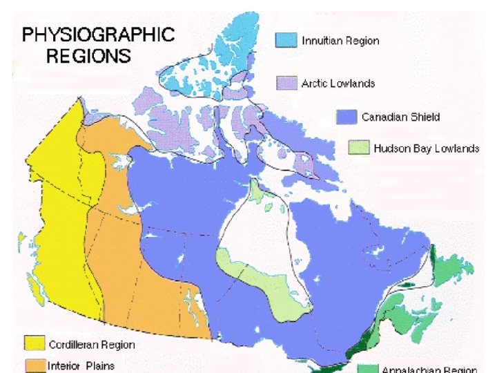
Canadian Landform Regions • Canada is so large that geographers divide it into regions to make it easier to study. • Geographers classify landforms based on a combination of characteristics: • - age of rock • - type of rock • - relief • - gradient • - process that has shaped the area • Look at Fig 2. 9 on p. 25 - the geologic history of earth.
Canadian Shield • Age of Rock: about 4 billion years old • Type of Rock: varies - mountains, plains, much of which is now sediment and pushed around to other areas of N. A. through glaciers and plate movement • Soil is thin and acidic, good forests, but not for agriculture except where deposits left by glaciers • Relief: varies from Appalachian Mountains to lowlands • Gradient: mainly flatter land • Process to shape area: moving water and ice through glaciers and plate movement • Area: parts of Sask. , Manitoba, Ontario, Quebec, Labrador, NWT and Nunavut
Appalachian Mountains • Age of Rock: Approx. 375 million years, N. A. and Eurasia plates collided • Type of Rock: Deposits in valleys have developed deep, fertile soils. • Relief: Typical mountain height about 1000 m • Gradient: not steep, but low, rounded mountains and wide valleys • Process to shape area: worn down by ice and water with rolling hills and broad valleys • Area: Most of Atlantic Canada
Western Cordillera • Age of Rock: formed during Cenozoic era • Type of Rock: many soils are rich and fertile due to sand silt deposited by rivers, especially in delta areas • Relief: Many mountains over 3000 m • Gradient: steep mountains (Coast, Columbia and Rocky Mountains) • Process to shape area: young mountains, steep, separated by plains. • Area: B. C. , Yukon, part of Alberta
Innuitian Mountains • Age of Rock: formed during Mesozoic era (younger than Appalachians) • Type of Rock: soil not great or fertile. Too cold in area for trees • Relief: Many mountains over 2000 m • Gradient: rugged peaks with steep-sided mountains • Process to shape area: erosion has not yet worn down mountains. • Area: Far north areas of Canada, including Ellesmere island
Arctic Lowlands • Age of Rock: Mesozoic Era • Type of Rock: upland plateaus and lowland plains • Relief: not far above sea level • Gradient: mainly treeless plains and tundra • Process to shape area: poorly drained soil • Area: Far north areas of Canada, south of the Innuitians
Interior Plains • Age of Rock: early Paleozoic to Cenozoic Eras • Type of Rock: rich soil up to 25 cm deep, ideal for wheat • Relief: varies, there are 3 plains areas carved out by erosion • Gradient: flat lands • Process to shape area: created when inland seas receded • Area: Most of Alberta, Sask, Manitoba and NWT (and south to the Gulf of Mexico)
Hudson Bay Lowlands Age of Rock: Paleozoic era Type of Rock: Paleozoic rock to depths of 2000 m Relief: lower than Shield areas Gradient: mainly flat and poorly drained Process to shape area: poor drainage leads to swampy forests, tundra and bog (referred to as Muskeg) • Area: Within the Canadian Shield, areas of Northern Ont. and Manitoba • • •
Great lakes-St. Lawrence Lowlands • Age of Rock: formed in the Paleozoic era • Type of Rock: some volcanic and faulting action left fractures in crust, with harder rock types, but mainly sand clay • Relief: lower than Shield areas, located south of the Shield • Gradient: nearly level with soil referred to as 'brown earth' • Process to shape area: was flooded by the Champlain Sea 10 000 yrs ago, then drained, leaving good base for soil • Area: from Southwestern Ont. along the St. Lawrence River to the mouth of the Sagueny River in Quebec