CameronCreole Watershed Grand Bayou Marsh Creation CS54 CCW
 CCW Advisory Board Meeting March 24, 2016")
Cameron-Creole Watershed Grand Bayou Marsh Creation (CS-54) CCW Advisory Board Meeting March 24, 2016

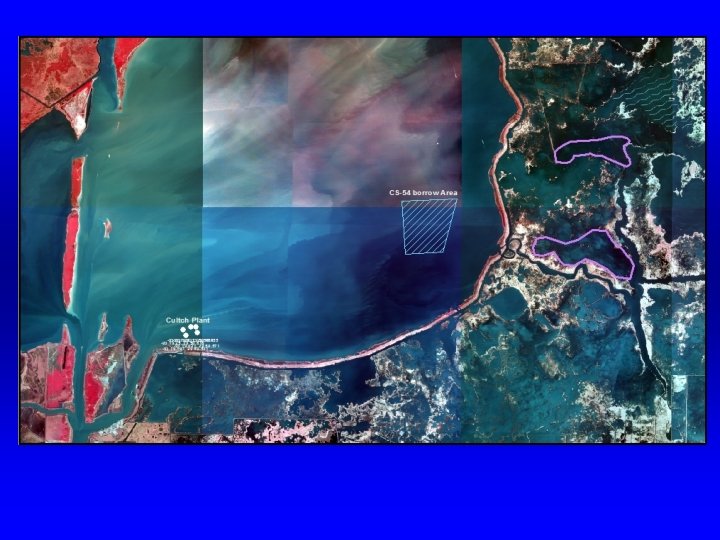
Project Location within the Calcasieu-Sabine Basin
 of the Cameron-Creole Watershed")
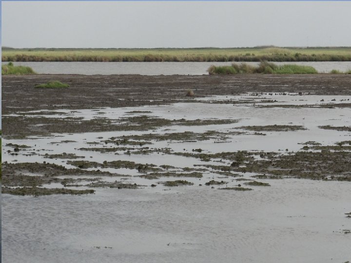
Project Area Marsh Loss • Approximately 14, 390 acres (32%) of the Cameron-Creole Watershed project (CCMP) marshes were lost to open water from 1932 to 1990 at an average loss rate of 248 ac/year (0. 55%/year) due to subsidence and saltwater intrusion from the Calcasieu Ship Channel. • The Cameron Creole Watershed Project was implemented by the NRCS in 1989 to reduce saltwater intrusion and stimulate restoration through revegetation. • Hurricanes Rita and Ike in 2005 and 2008 breached the watershed levee scouring the marsh and allowing higher Calcasieu Lake salinities to enter the watershed causing more land loss. • The Calcasieu-Sabine Basin lost 28 mi 2 (17, 920 acres) (4. 4%) as a result of H. Rita (Barras et al. 2006). • Project area marsh loss is determined to be -1. 3 %/year based on USGS 19852009 linear regression. 6/16/2021

Project Area Storm History: Hurricane Rita 6/16/2021

Project Area Storm History Project Area: September 2004 Project Area: May 2009 Hurricane Rita: September 2005 Hurricane Ike: September 2008 6/16/2021

Project Purpose • Rebuild the marsh lost due to scour and storm surge by Hurricanes Rita and Ike • Re-create low salinity brackish marsh in the open water areas immediately behind the Cameron-Creole Watershed levee north of Grand Bayou • Buffer tidal exchange through the Cameron-Creole Watershed • Restore marshes that support the Calcasieu Lake estuary & State and Federal trust resources

Species of Conservation Concern • seaside sparrow • Nelson’s sparrow • rails – king, clapper, black • little blue heron • reddish egret • mottled duck • Louisiana-eyed silkmoth © Brent Ortego/seaside sp

Project Background • Feb 2010 - Nominated by the FWS in January at the Region 4 RPT meeting • Apr 2010 - Selected by CWPPRA Technical Committee as PPL 20 Candidate • Jan 2011 - Phase I approval as part of the 20 th PPL – Mar 2013 - 30% Design Meeting – Oct 2013 - 95% Design Meeting • Dec 2014 - Phase II Funding Request @ TCM – Selected • Jan 2015 - Phase II Construction funding awarded at TFM • July 2015 – CWA 404 Permit received

Project Proposal

Marsh Creation Design Analysis Northern Cell • • Existing Elevation: -0. 17 ft. NAVD 88 Target Slurry Elevation (TY -0): +3. 7 ft. NAVD 88 Target Elevation at TY-20: +1. 1 ft. NAVD 88 Total Settlement: 2. 6 ft. CRMS 0650 6/16/2021

Marsh Creation Design • Marsh Construction Elevation: • Containment Dike Elevation: Northern Cell: Southern Cell Fill Volume Marsh Creation Area Northern Cell Southern Cell 6/16/2021 Est Total: Volume (yd 3) ~ 700, 000 1, 300, 000 ~2, 000 +3. 2 ft. NAVD 88 (Max: +3. 7 ft. NAVD 88) +3. 4 ft. NAVD 88 (Max: +3. 9 ft. NAVD 88) +4. 7 ft. NAVD 88 +4. 9 ft. NAVD 88 Borrow Volume C: F Ratio 1. 5: 1. 0 Marsh Creation Area Northern Cell Southern Cell Total: Volume (yd 3) 1, 100, 000 2, 000 3, 100, 000

Project Benefits and Costs • The project benefits 616 acres of marsh and open water habitats • 476 net acres at the end of the 20 -year project life • Fully funded cost of $28, 707, 688

Avoidance and Minimization of Impacts to Fishery Resources with Calcasieu Lake • Conducted Surveys: • Bathymetry Surveys • Bottom Assessments • Seismic Surveys • Realigned Borrow Area to avoid: • Buried or exposed shell (predominantly rangia shell) • Pipelines • LDWF shrimp sampling site • Monitoring Plan: • Borrow Area Surveys • Water Quality Monitoring. DO and Hypoxia • Outreach

• • • Borrow Area: ~ 400 Acres Less than 1% of Calcasieu Lake by Area Depth of Dredging: 10 Feet below mud line Existing Lake Bottom Elevation: -6 Feet Permitted Borrow Area Bottom Elevation: -16 Feet Borrow Area

Project Support • • • Landowners: NWR & Miami Cooperation Coastal Conservation Association The Chamber Southwest LA Calcasieu Parish Cameron Parish City of Lake Charles
")
Courtesy of Steve Stewart, Suzanne Richard, Reggie Keogh (facebook. com/Cameron. Prairie. NWR)
- Slides: 18