Cambodia Profile of Battambang Municipality ongoing for CPI
 By Thuon Try Faculty of Development")
Cambodia: Profile of Battambang Municipality (ongoing for CPI) By Thuon Try Faculty of Development Studies, Royal University of Phnom Penh IUTC, Korea 13 -17 July 2015

INTRODUCTION TO BATTAMBANG

Location • Battambang municipality is the central and provincial town of Battambang Province. • Municipality covers an area of 115. 44 km 2 of which 74% are agricultural land. • The municipality consists of 10 Sangkat (Communes) with 92 villages. • The topography is flat. Tonle Sap Lake sits to the East and is connected to the Sangke River, which runs through the town.

Location • The town covers an area of 11, 544 ha. Cultivated areas with 8557. 5 ha, construction land areas (ha) with 2, 869. 7 and other land with 116. 6 ha. • Currently, only about 30 % is urbanized. The town centre is on west bank of the river – 90% of commercial and residential establishments.
 shows the city has existed")
History • Historical records (stone scripts and archeological evident) shows the city has existed since 11 th century during the Khmer Empire. Significant development occurred during the following events: • From 1705 -1907: small town with about 2500 residents, stretching along the west bank of Sangker River with one road parallel to the river. • From 1907 -1953: French colonial period of which the first and second urban development plan were developed: such as bridge, railway, market, business center and modern buildings (1907 and 1926 respectively).

History • From 1953 -1970: Golden era’s when urban layout of Battambang was enlarged five times the size of the French colonial town. Third urban development planning and development occurred (industrialisation, commercial centers, infrastructure, schools, sport centers, . . . ). • From 1970 -1990 s: civil war • From 1990 s to present: Battambang has emerged again in terms of national development and regional integration.
 No 1 2 3")
Demography Population by 2010 Shows 142, 878 (female: 68, 824) No 1 2 3 4 5 6 7 8 9 10 Total: Sangkat Tuol Ta Ek Preaek Preah Sdach Rottanak Chamkar Samraong Sla Kaet Kdol Doun Teav Ou Mal Vaot Kor Ou Char Svay Pao Total Land (km 2) Population 3. 77 16, 182 2. 9 12, 779 6. 79 13, 877 9. 18 16, 075 7. 47 6, 713 9. 06 9, 389 37. 74 10, 398 24. 94 18, 232 11. 17 21, 475 2. 42 17, 758 573 142, 878 Density/sq/ km 4, 288 4, 407 2, 044 1, 751 899 1, 037 276 731 1, 921 7, 304

Population projection to 2020 Population projection by 2020 216, 114 220, 000 209, 819 210, 000 203, 708 197, 775 200, 000 201, 883 196, 959 192, 015 180, 992 180, 000 175, 720 170, 602 170, 000 156, 125 160, 000 151, 579 140, 000 157, 711 153, 864 147, 164 150, 111 154, 656 151, 624 146, 450 148, 651 145, 736 157, 749 160, 904 164, 122 167, 404 188, 524 182, 896 174, 083 165, 695 161, 654 187, 468 178, 435 169, 837 165, 633 160, 809 150, 000 192, 155 186, 422 190, 000 170, 752 174, 167 177, 650 181, 203 184, 827 3% 2. 50% 2% 130, 000 2007 2008 2009 2010 2011 2012 2013 2014 2015 2016 2017 2018 2019 2020

Economy • Main economic activities dominated by agriculture (rice, vegetable, livestock and poultry farming, fishing, and NTFP collections). • However the services and manufacturing sector has significantly grown in recent years. • Tourism activities: cultural villages, traditional houses, museums and entertainment. • Battambang is now being transformed into an agroindustrial hub, tourism attraction and competitive city for public and private sector investment.

Natural systems • Sangker River originates from the Elephant and Cardamom Mountains at an elevation of about 1, 391 msl, then flows across the town and joins various rivers and tributaries before flowing into Tonle Sap Lake.

Natural systems • There are three protected areas associated with the Sangker river system: Phnom Samkos Wildlife sanctuary, Sam Lout Multiple Use Areas and Tonle Sap Multiple Use Area - total 710, 000 ha.

Hydrological system This map shows at least four river basins connected to Battambang and Sangker River: Stung Svay Don Keo (2, 228 Km 2), Stung Moung Russei/Dauntry (1, 469 km 2), Stung Monkul Borey (5, 264 km 2) and Stung Sisophon (5, 595 km 2).

Battambang at a cross road • Battambang in recent years has reactivated its strategy to take advantage of its location to become an economic and trading center. • Infrastructure plays an important role for economic activities and human interaction which includes: – National road No. 5 connecting municipality to other provinces, Phnom Penh and Thailand. – National road No. 57 connecting No. 5 and other urban areas. – National railway: connecting from Phnom Penh to other parts of the country and borders. – Battambang air port is situated close to the urban center but not working since 2003.

TOWN MASTER PLAN

Future town development plan & infrastructure Vision for 20082020

Future land use plan Development zones according to the land-use categories (residential zones, mixed –used zones, commercial zones, administration zones, cultural zones, and others).

Commercial zones

Environmental protection zones

Green strategy

Key infrastructures-to be rehabilitated

MAIN CLIMATE THREATS IN BATTAMBANG
 Annual Flood (M 3/S)")
Climate change ‘hot spots’ Year Max. Annual Water Level (M) Annual Flood (M 3/S) 1999 2000 2001 2002 2003 2004 2005 2006 2007 2008 2009 2010 2011 Average 12. 37 13. 44 12. 14 11. 59 13. 02 12. 08 13. 39 13. 71 13. 50 12. 14 12. 08 11. 12 13. 95 12. 66 634 1009 569 433 846 552 988 1125 1034 569 552 337 1235 760 • Flooding has been recorded in every Sangkat of the municipality in wet season; mostly occurs in October and December. • Svay Por, Prek Preah Sdach with depth range from 1 to 2 meters.

The recent flood in 2013 • 2013 flood worst ever recorded - water level reaches highest level up to 14. 2 m on Sangker river. • Normally, when water level reaches 12. 5 m, water starts to flow into town and lowland wetland areas.
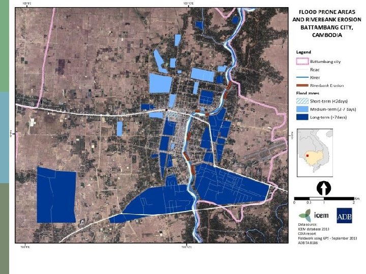

Flood Risk maps prepared by core group

Flood duration

Flood depth

Battambang terraine

Projected changes to average rainfall & maximum temperatures by 2050 Average annual rainfall: Total rainfall in wet season: Total rainfall in dry season (Mar - Aug): Average daily maximum temperature (Annual) Average maximum temperature in wet season: Average maximum temperature in dry season: Baseline With C. C. Change 1300 mm 1365 mm +5 % 1170 mm 1267 mm +8. 3 % 230 mm 224 mm -2. 5 % 32 C 34. 2 C +2. 2 C 31 C 33. 6 C +2. 6 C 32. 5 C 34. 4 C +1. 9 C

Changes in rainfall with climate change • By 2050, Battambang’s total rainfall in the wet season would increase by about 8. 3%

Changes in temperature with climate change • By 2050, Battambang’s average daily maximum temperature during the dry season would increase by between 1. 8 -1. 9 C

Summary of expected climate changes in 2050 • Battambang is expected to be: § Significantly hotter and wetter in the wet season § Hotter and drier in the dry season

TOWN ZONE SAFEGUARDS FOR CLIMATE CHANGE

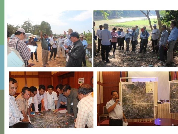
Core Group working on hot spot maps and safeguards

Safeguards in hot spot zones • Strategic infrastructure not to be build in hot spots zones – eg hospitals, government buildings, fuel storage and power plants • All developments required to maximise ratio of green cover to building space • All developments required to manage drainage and runoff on site. • Special design standards for buildings allowing for rain water capture and storage and flood water flow and storage. • Environmental Impact assessment of all developments proposed for hot spots

TARGET SITE ADAPTATION AND DEVELOPMENT CONTROL

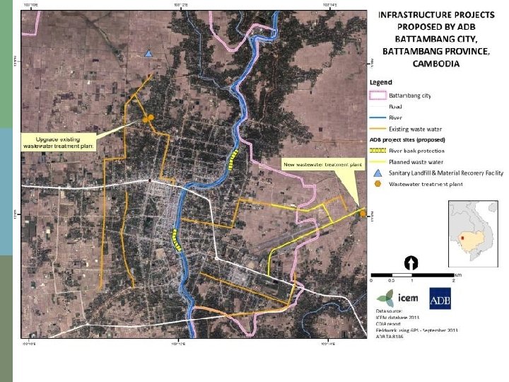
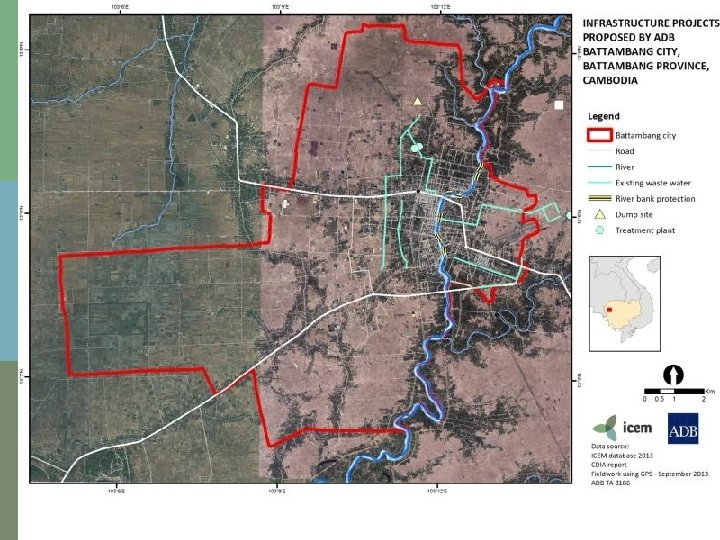
Kampong Seima canal system • The canal extends across six Sangkat and two national roads (No. 5 and No. 57). • This canal is an important backbone drainage and flood management facility for the town. The core group has envisioned that this canal would become a green belt surrounding the town with multiple community and economic uses. • There is also a need to construct wastewater treatment facilities at the lower end of the canal before releasing water into agricultural zones and also to regulate illegal migrant resettlement along the canal system.

Improvement of wastewater system and installation of treatment plant • The investment for the improvement of the wastewater systems and the installation of an appropriate wastewater treatment plant including sewerage pipelines will contribute in making Battambang municipality an attractive, liveable and competitive town. • This will include 3 km of open and closed channel drainage structures along existing canals in the northern and eastern portion of Battambang. • A 5 ha has been identified as the site of the Plant.

River Embankment Protection and Flood Control Measure • The protection of Sangker River embankment will mitigate the erosion of the riversides and make economic use of available space for commercial and recreational purposes. • This involves civil works for the protection of the river embankment on the eastern side of the Sangker river and the rehabilitation of drainage structures in the town center and adjacent suburban areas.

Railway rehabilitation and resettlement • There are slum villages living surround the station as well as the current lake called Boeng Toul Ta Ek. • The lake plays an important role in flood retention to protect the city and also purify water before releasing through various drainage system and potential water treatment.

THANK YOU
- Slides: 44