
BoundaryLayer Dispersion Urban Meteorology Will Pendergrass NOAAARLATDD OAR
Boundary–Layer Dispersion Urban Meteorology Will Pendergrass NOAA/ARL/ATDD OAR Senior Research Council Meeting Oak Ridge, TN August 18 -19, 2010 11/25/2020 Air Resources Laboratory
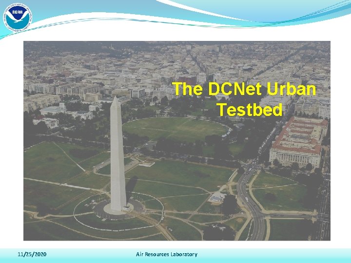
The DCNet Urban Testbed 11/25/2020 Air Resources Laboratory
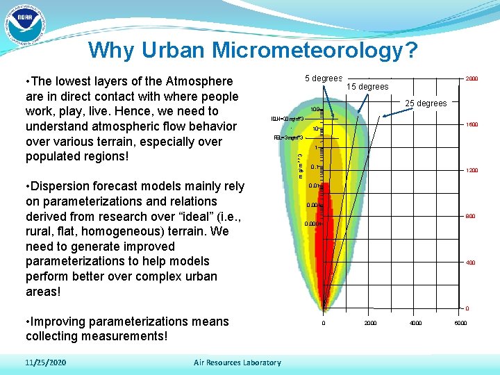
Why Urban Micrometeorology? 5 degrees 2000 15 degrees 25 degrees 100 IDLH=30 mg/m**3 1600 10 PEL=3 mg/m**3 • Dispersion forecast models mainly rely on parameterizations and relations derived from research over “ideal” (i. e. , rural, flat, homogeneous) terrain. We need to generate improved parameterizations to help models perform better over complex urban areas! 1 m g/m * *3 • The lowest layers of the Atmosphere are in direct contact with where people work, play, live. Hence, we need to understand atmospheric flow behavior over various terrain, especially over populated regions! 0. 1 1200 0. 01 0. 001 800 0. 0001 400 0 • Improving parameterizations means collecting measurements! 11/25/2020 Air Resources Laboratory 0 2000 4000 6000
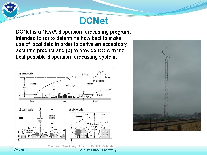
DCNet is a NOAA dispersion forecasting program, intended to (a) to determine how best to make use of local data in order to derive an acceptably accurate product and (b) to provide DC with the best possible dispersion forecasting system. 11/25/2020 Air Resources Laboratory
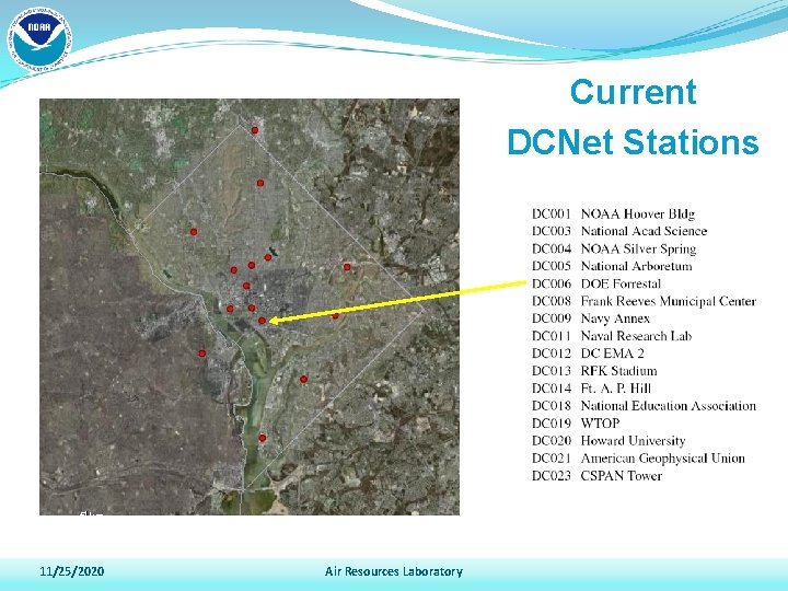
Current DCNet Stations 2 km 5 km 11/25/2020 Air Resources Laboratory
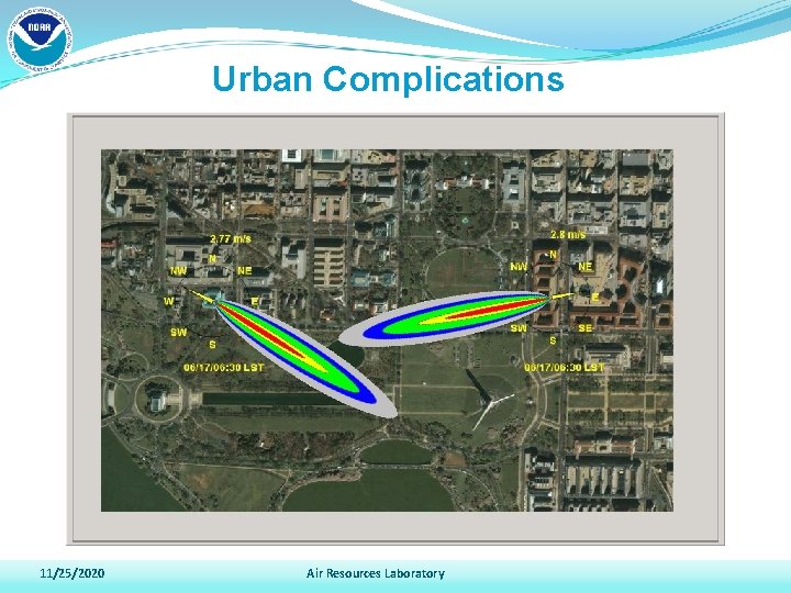
Urban Complications 11/25/2020 Air Resources Laboratory
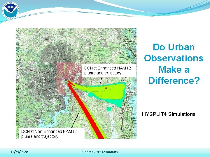
DCNet Enhanced NAM 12 plume and trajectory Do Urban Observations Make a Difference? HYSPLIT 4 Simulations DCNet Non-Enhanced NAM 12 plume and trajectory 11/25/2020 Air Resources Laboratory
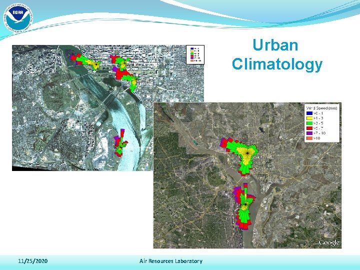
Urban Climatology 11/25/2020 Air Resources Laboratory
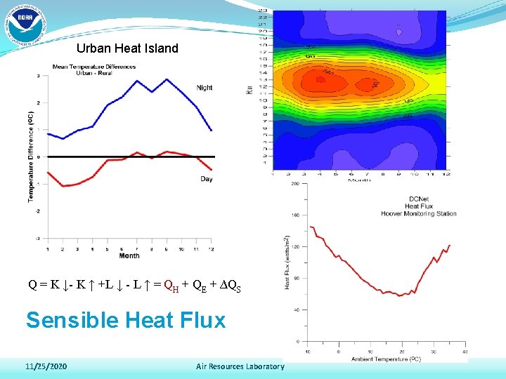
Urban Heat Island Q = K ↓- K ↑ +L ↓ - L ↑ = QH + QE + ∆QS Sensible Heat Flux 11/25/2020 Air Resources Laboratory
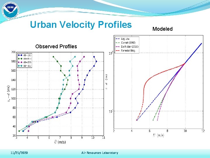
Urban Velocity Profiles Observed Profiles 11/25/2020 Air Resources Laboratory Modeled
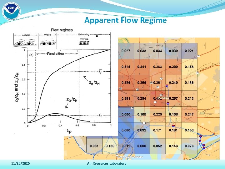
Apparent Flow Regime 11/25/2020 Air Resources Laboratory
2010 Cal. Nexus Science Questions Transport and Meteorology Goal: Improved Urban Canopy Layer Parameterizations • How best can we characterize and model air flow over coastal waters and the complex terrain of California? • What are the major deficiencies in the representation of chemistry and meteorology in research and operational models and how can models be improved through the collection of additional measurements? What physical and chemical processes are not captured well by available models? Is there an optimum grid resolution to capture all of the relevant physical and chemical processes that occur? 11/25/2020 Air Resources Laboratory
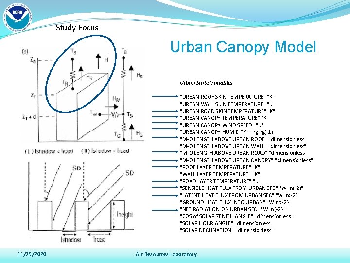
Study Focus Urban Canopy Model Urban State Variables "URBAN ROOF SKIN TEMPERATURE" "K" "URBAN WALL SKIN TEMPERATURE" "K" "URBAN ROAD SKIN TEMPERATURE" "K" "URBAN CANOPY WIND SPEED" "K" "URBAN CANOPY HUMIDITY" "kg kg{-1}" "M-O LENGTH ABOVE URBAN ROOF" "dimensionless" "M-O LENGTH ABOVE URBAN WALL" "dimensionless" "M-O LENGTH ABOVE URBAN ROAD" "dimensionless" "M-O LENGTH ABOVE URBAN CANOPY" "dimensionless" "ROOF LAYER TEMPERATURE" "K" "WALL LAYER TEMPERATURE" "K" "ROAD LAYER TEMPERATURE" "K" "SENSIBLE HEAT FLUX FROM URBAN SFC" "W m{-2}" "LATENT HEAT FLUX FROM URBAN SFC" "W m{-2}" "GROUND HEAT FLUX INTO URBAN" "W m{-2}" "NET RADIATION ON URBAN SFC" "W m{-2}" "COS of SOLAR ZENITH ANGLE" "dimensionless" "SOLAR HOUR ANGLE" "dimensionless" "SOLAR DECLINATION" "dimensionless" 11/25/2020 Air Resources Laboratory
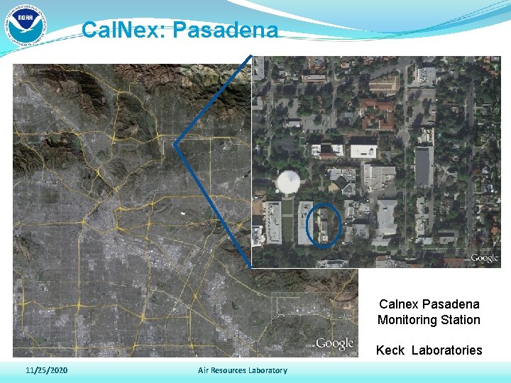
Cal. Nex: Pasadena Calnex Pasadena Monitoring Station Keck Laboratories 11/25/2020 Air Resources Laboratory
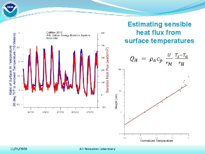
Estimating sensible heat flux from surface temperatures 11/25/2020 Air Resources Laboratory
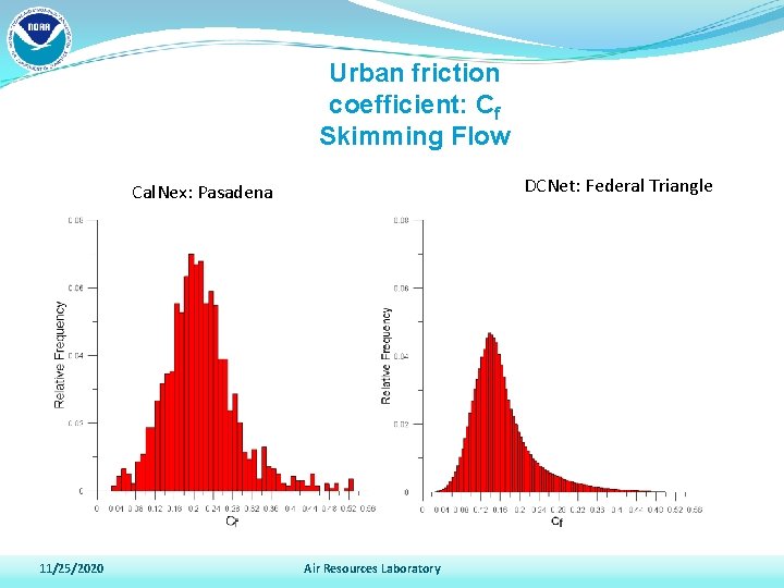
Urban friction coefficient: Cf Skimming Flow DCNet: Federal Triangle Cal. Nex: Pasadena 11/25/2020 Air Resources Laboratory
Cal. Nex Status • Meteorological data transferred to community ftp site • Abstract submitted for AGU special session • High frequency spectral data in review • Complete energy balance components in review 11/25/2020 Air Resources Laboratory
Urban Meteorology Future Directions • Conduct research over other types of terrain such as suburban regions, coastal cities, etc… • Assess changes in turbulent flow along transects from suburban to suburban. • Assess spatial variability of vertical profiles of mean winds and turbulence; mobile remote sensing. • Observe the budget of TKE: Does the oft-used “local dissipation” assumption for turbulence (rates of mechanical and buoyant production equals rate of viscous dissipation) hold above the urban canopy? 11/25/2020 Air Resources Laboratory
- Slides: 18