Boat Densities and Carrying Capacities Boat Density and

Boat Densities and Carrying Capacities

Boat Density and Carrying Capacity What are they? Why do I care? What does this have to do with relicensing?

Definitions ▲Boat density - The number of boats per unit area. May include type of boat/activity, and may address shoreline configuration and availability of open water ▲Carrying capacity – The type and level of visitor use that can be accommodated while sustaining the desired resource and social objectives (NPS, 1997)

▲ Boat density is a building block used to estimate carrying capacity ▲ Other building blocks might include number/type of public access sites, shoreline development, sensitive resources, water quality…. and the list goes on

Compared… Boat Density May Include… ▲ ▲ Number of boats per acre Type of boat or activity Shoreline configuration Volume of use (user expectations based on proximity to population and shoreline development) Carrying Capacity May include… ▲ ▲ ▲ ▲ Accident data (on the water) Aquatic and submerged habitats Boat density Commercial access & development Cultural & historical properties Flora and fauna Private / residential access & development Public or user preferences Shoreline configuration Shoreline erosion Shoreline habitats Special events (tournaments, regattas) Water quality
 that can")
Carrying Capacity ▲Provides an estimate of a number of boats (or people) that can be accommodated physically and socially by a specific area of water USE WITH CAUTION! Remember, usually a FERC licensee does not control boating on the water. Carrying capacity estimates can guide management decisions, but are generally not used by licensees to limit boating activity. A licensee will not count boats daily and start evicting boaters from a lake when the number of boats exceeds an estimated carrying capacity!

First… ▲Typically, a licensee is responsible for managing recreational use and related development within its Project Boundary on the shoreline or submerged lands. ▲Usually, a state agency or agencies are responsible for managing activity on the water at FERC-licensed projects. ØFishing, boating, etc.

Second…Avoid Duplication of Effort Carrying Capacity Study ▲ ▲ ▲ ▲ Accident data (on the water) Aquatic and submerged habitats Boat density Commercial access & development Cultural & historical properties Flora and fauna Private / residential access & development Public or user preferences Shoreline configuration Shoreline erosion Shoreline habitats Special events (tournaments, regattas) Water quality Shoreline Management Plan ▲ ▲ ▲ ▲ Aquatic and submerged habitats Boat density Commercial access & development Cultural & historical properties Dredging Flora and fauna Permitting Private / residential access & development Public or user preferences Shoreline erosion Shoreline habitats Water quality
 ▲Duke Energy Corp. for")
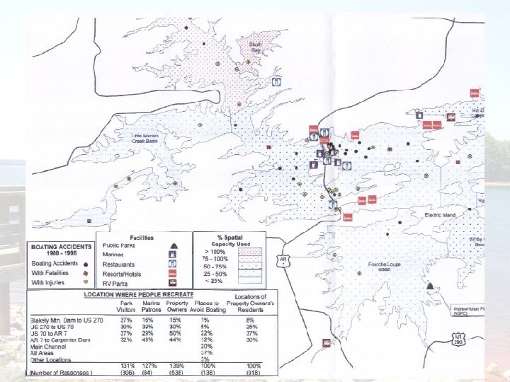
Examples ▲Entergy Arkansas, Inc. for the Carpenter. Remmel Project (1999) ▲Duke Energy Corp. for the Nantahala Area Projects (2003) ▲GRDA for the Pensacola Project (2006)

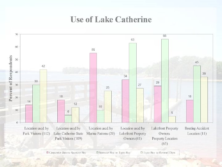
Entergy’s Lake Hamilton and Lake Catherine study… of g s t n un ludi rs , o l c (inc skie iers a i k r s Ae ater s, jet ter s e , bo gler , wa asur ats re o an WC) , ple ur b r the s, (P ers s, to rive ater tub ater the , flo re bo d on glers ) we a an an rfers on a for are d su ted ays. an mple of d eriod co mple ar p sa e ye on s le wa n each p m sa hi The uted wit nate to io ib s distr proport r of day e f th mon tal numb A total o t. o a the t h month ampled c s in ea ys were ent. m a 40 d impound nth, o each m ere in With le days w type y p sam ied by da ekend if e strat days, w ays) and k d (wee and holi , days f day. o time

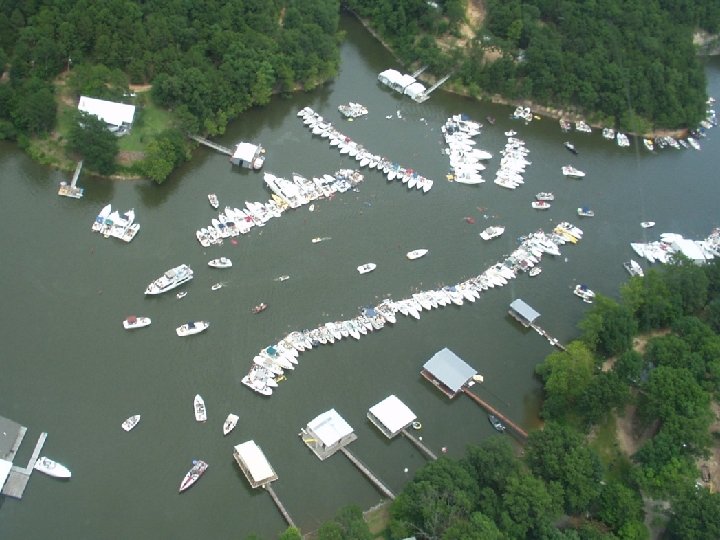
Nanatahala Weekend Crowding

What Can We Learn? ▲Identify areas of unique uses ▲Identify areas of crowding ▲Identify where use can be spread out to help protect/manage other resources ▲Inputs into shoreline management decisions ▲Identify information needs ▲Identify needed expansions at facilities to address user needs

Licensee Considerations ▲ Avoid setting a carrying capacity number that will require restrictions on public access ▲ FERC does not advocate restricting access to project waters. Tailor decisions based on all resources and remember, environmental and social considerations are dynamic: management plans should be too. ▲ Determine the metrics that you will consider before starting data collection ▲ There’s nothing more frustrating than finding out that the data collected will not answer the question asked. ▲ Be comfortable with agencies and stakeholders – know where your responsibilities begin and end ▲ A licensee’s responsibility is to provide and manage access to project waters. It may not include management of activity on the water. ▲ Work with agencies and stakeholders. ▲ You may need them to provide information (data, expertise, etc) or implement some of the resulting recommendations. Cooperation and buy-in from stakeholders will always result in a more accepted and workable management plan.
- Slides: 17