BOARD EXAMS IDENTIFY YOUR STRENGTHS MAKE YOUR STRENGTH

BOARD EXAMS IDENTIFY YOUR STRENGTHS MAKE YOUR STRENGTH STRONG EAT WELL AND SLEEP WELL REACH WELL BEFORE TIME USE READING TIME WISELY NEW ANSWER NEW PAGE

4/6 figure grid reference Interpretation scale TOPO SHEETS Contour Height Direction and distance Areas

Eastings Northings Vertical Lines Horizontal Lines North to South East to West Numbered 00 to 99 Placed 2 cm (1 km) apart Value increases towards east Value increases towards north

EASTINGS N O R T H I N G S

REMEMBER L

6 figure reference of G is 2 5 x 7 7 y x = a / 2 y = b / 2 Truncate the decimals If a = 13 mm; b = 11 mm 6 figure grid reference is 256775 3. 5 BECOMES 3 25 20 mm 78 a 77 G b 26

Use toposheet 45 D/7, Easting 76 to 87, Northing 73 to 85 Find the six figure grid reference of a. Post Office in the North. East b. Temple north of Godh c. ∆169 d. Tomb near Vaghrol e. ∆317 Answers a. 844806 b. 781833 c. 780778 d. 846764 e. 793755
 Distance between the")
Scale is a RATIO Distance between two places on map (a) Distance between the same two places on ground (b) • Can be expressed as 1. Statement (2 cm = 1 km OR 2 cm to 1 km) 2. Representative Fraction (1: 50000) 3. Linear Scale

Statement to R. F. • If a = 2 cm; b = 1 km • Scale = 2 cm / 1 km 2 cm / 1 X 1000 X 100 cm 1 cm / 50000 cm 1 : 50000 OR OR OR

FINDING DIRECT DISTANCE 1. Measure the distance between the centre of the two places in cm 2. Convert distance in km (or metres) (Use the scale, i. e. ; 2 cm = 1 km) 3. Round off to nearest 0. 25 km (250 metres)

FINDING INDIRECT DISTANCE 1. Place a string along the path between the centre of the two places 2. Measure the length of the string in cm 3. Convert distance in km (or metres) (Use the scale, i. e. ; 2 cm = 1 km) 4. Round off to nearest 0. 25 km (250 metres)

Direction From ‘O’ to ____ OR Of __ from ‘O’ E A G o C F D B

E A G o C F D B

Normal direction and Forward Bearing 0° 315 ° 45 ° 270 ° 90 ° 225 ° 135 ° 180 °

Finding Areas REMEMBER Every grid is 1 km X 1 km =1 sq km

Visual method 90 42 89 88 87 86 85 84 43 44 45 46 47 48
 Area enclosed = f.")
Correct solution 1. Area enclosed by full grid squares (f) Area enclosed = f. X 1 1. Area enclosed by half grid squares (h) Area enclosed = h. X½ 1. Area enclosed by more than half grid squares (m) Area enclosed = m X 2/3 1. Area enclosed by less than half grid squares (l) Area enclosed = l X 1/3

TOTAL AREA • Total area f X 1 + h X ½ + m X 2/3 + l X 1/3

Correct solution - Visual method 90 42 43 44 45 46 47 48 89 l m h h l l 88 h f f l 87 m f f f m 86 m f f f h 85 l m m m 84

TOTAL AREA • Finding the total area f X 1 = 10 X 1 = 10 sq. km + h X ½ = 4 X ½ = 2 sq. km + m X 2/3 = l X 1/3 = 5 X 1/3 Total Area = 7 X 2/3 = = 4. 67 sq. km 18. 34 sq. km = +

To be answered using toposheet 45 D/10, Grid reference 10 to 18, Northing 16 to 28 Find the area of uncultivated land between eastings 14 and 18 and northings 24 and 28. Answers 11 Sq. Km

Height 1. Triangulated Height 2. Spot Height 3. Relative Height

Triangulated Height • • Determined using principles of trigonometry Accurate Expressed on maps using a ∆ For example, ∆ 224

Prominent Surveyed Tree • Triangulated height written on tree bark • Tree is shown in black colour- • For example

Bench Mark • Triangulated height written on nearby rock or wall • Shown using BM • For example, BM 403

Spot Height • Height estimated using the value of adjacent contours • Shown with a dot • For example, . 544 0 56 54 0 . 544
 of a feature relative to surroundings • Shown using")
Relative Height • Height (depth) of a feature relative to surroundings • Shown using r • For example, 20 r

Example of relative heights Symbol Meaning Relative height of river bank is 7 metres 7 r 11 r Relative height of Sand Dune is 11 metres Relative height of Tank Embankment is 14 metres 14 r 22 r Relative Depth of PL Well is 22 metres

CONTOURS

INDEX CONTOURS

FORM LINES Drawn where it is not possible to draw contours and there is a prominent relief feature which is lesser in height than the contour interval

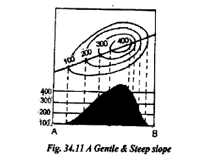
Spacing between contours • Widely spaced contours – Gentle slope • Closely packed contours – Steep slope • Overlapping contours – Vertical slope

Uniform Gentle Slope 220 240 260 280 300 320
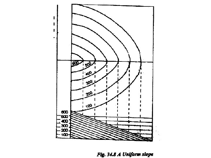

Uniform Steep Slope 320 300 280 0 26 240 220 200 180 160 140

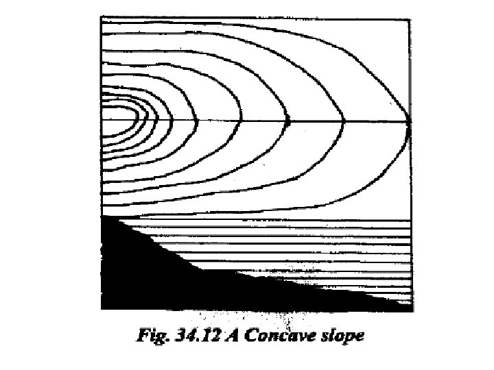
Concave Slope 28 300 0 32 0 0 26 24 0 0 22

Convex Slope

VISUALISATION

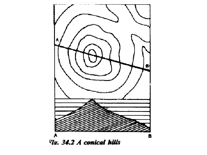
CONICAL HILL 320 300 280 260

ASYMMETRICAL HILL 320 300 280 260

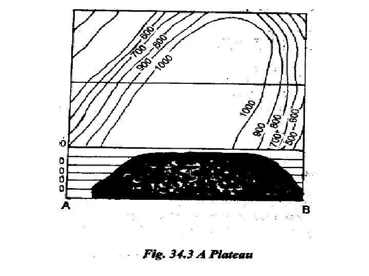
CIRCULAR PLATEAU 320 300 280 260
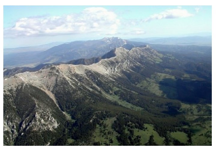

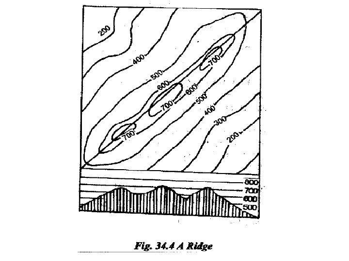
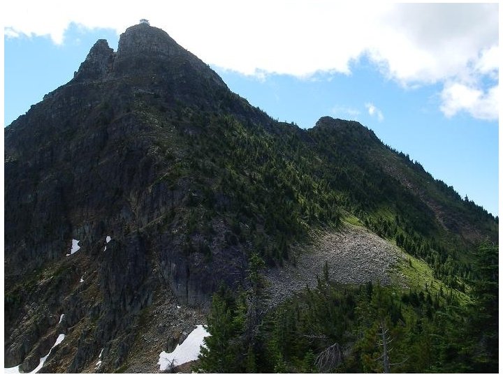
RIDGE 320 300 280 260

SADDLE 320 300 280 260

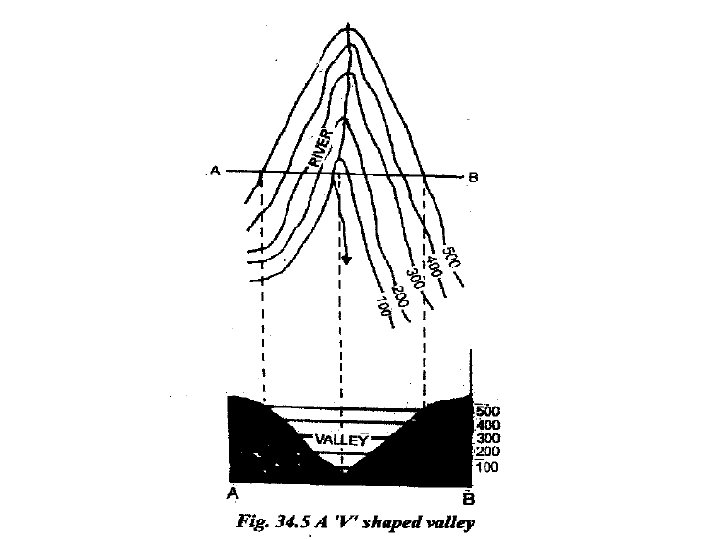
V SHAPED VALLEY 240 220 200 180 340 280 260 320 300

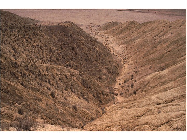
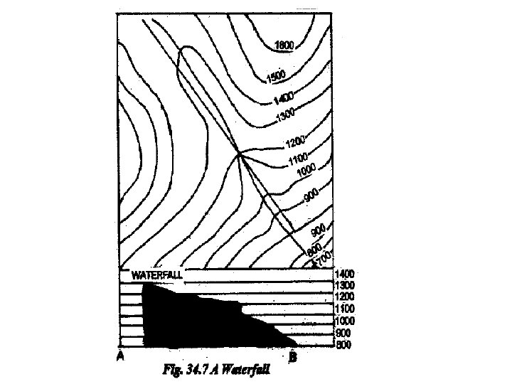
WATERFALL 240 280 260 340 320 200 300
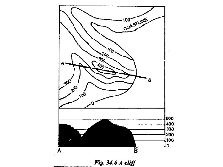

An Escarpment

Type of Drainage Patterns 1. 2. 3. 4. 5. Radial Trellised Dendritic Disappearing Combinations of one or more of the above

Radial Drainage pattern • Hill in the centre • Streams flow outward in different directions

Trellised Drainage Pattern • Streams parallel to each other

Dentritic Drainage Pattern • Random arrangement of streams

Disappearing stream • Stream may disappear in its course due to – Evaporation – Flowing through sandy area – EVIDENCE OF SEASONAL RAIN

SETTLEMENT PATTERN

Nucleated and Linear

Nucleated and Radial

Dispersed Settlement Pattern

Modes of Transport Metre Gauge Railway Metalled Road Unmetalled Road

Modes of Transport Cart Track Pack Track Foot Path

What is irrigation? • Artificial means of availing water – River is not a mode of irrigation • Required if area receives seasonal rainfall
 tank with embankment Dam Canal IN D/10 1822 D/7 8079")
Modes of irrigation (Dry) tank with embankment Dam Canal IN D/10 1822 D/7 8079 (UNDER CONSTRUCTION)

Modes of irrigation Perennial lined well Perennial Unlined well Tubewell Perennial lined well with brackish water Brackish

INTERPRETATION OF TOPOGRAPHICAL MAPS

INTERPRETATIONS DRAWN 1. 2. 3. 4. Occupation Climate and Vegetation General Slope Relief

Occupations in 45 D/7 and 45 D/10 1. 2. 3. 4. 5. 6. 7. 8. Agriculture Cattle Rearing Construction Public Services Trade Tourism Education Lumbering

AGRICULTURE • True for all parts of 45 D/7 and 45 D/10 except Abu • Evidences – Yellow Colour (indicating cultivated land)

CATTLE REARING • True for all parts of 45 D/7 and 45 D/10 except Abu • Supplementary with Agriculture • Provides monthly income • Evidences – Yellow Colour (indicating cultivated land) – Tanks with embankments – Cart Tracks

CONSTRUCTION • Evidences – Lime Kiln – Brick Kiln – Stone Quarry – Metalled Road under construction – Canal under construction

PUBLIC SERVICES • True of larger villages and the town of Abu • Evidences – Post Office – Police Station – Dak Bungalow – Inspection Bungalow – Dispensary, etc.

TRADE • True for larger settlements • Evidences – Nucleated and radial settlement pattern

TOURISM • True for the town of Abu • Evidences – Hill Station – Nakki Talao – Delwara Temple – Sun Set Point – Anadra Point – Palanpur Palace – Jai Vilas Palace

EDUCATION • True for the town of Abu • Evidences – St. Mary’s High School – Sophia High School

LUMBERING • True for small dispersed settlements • Evidences – Settlement near of within forest

CLIMATE AND VEGETATION

CLIMATE IN 45 D/7 AND 45 D/10 • Tropical Monsoon type of climate SEASON MONTHS CHARACTERISTICS SUMMER March to May Hot and Dry (45 °C) RAINY SEASON June to September Scanty Rainfall (50 cm) WINTER December to February Cool and Dry (0 °C)
 streams Dry Tanks")
Evidences of Seasonal Rainfall 1. 2. 3. 4. 5. Dry (seasonal) streams Dry Tanks Broken Ground Open scrub Wells

POSSIBLE VEGETATION • Tropical Deciduous Trees – Neem – Banyan – Peepal • Desert Vegetation – Acacia (Babool) – Cactus – Date Palms

MEANING OF GENERAL SLOPE • Direction towards which the terrain is inclined • Can be determined by finding the direction in which the river system flows

FINDING DIRECTION OF RIVER FLOW 1. Arrow in the river bed – Direction in which water will flow 2. Angle at which tributaries meet – Tributaries follow the main river – Tributaries meet at an acute angle 1. Direction in which river widens

GENERAL SLOPE D/7 South West Sipu- South West Hills in South East West D/10 South West -Sipu-NE to West - Sukli- South to North West South West North West South Hills in North East

TYPES OF RELIEF • High relief – Hilly terrain – Range of heights • Low Relief – Flat plain – Lower heights in a small range

NATURE OF HILLS / MOUNTAINS • • • Location Area occupied Average height Highest and lowest point Alignment / Trend of hill ranges

NATURE OF RIVERS • • • Direction of flow Presence of sediment Width Presence of water Flowing through broken ground Tributary or main river

CONVENTIONAL SYMBOLS

Water bodies Perennial Stream Dry river with sediment and perennial channel

Water bodies Spring Dry / seasonal stream Perennial Lake Dry / Seasonal Tank
 tank with embankment, Natural/Man-made Dam Canal")
Modes of irrigation (Dry) tank with embankment, Natural/Man-made Dam Canal

Modes of irrigation Perennial lined well Perennial Unlined well Tubewell Perennial lined well with brackish water Brackish

Places of Worship Temple Tomb / Chhatri

Miscellaneous Man Made Features Telephone Line Self explanatory Causeway Small bridge built to maintain level of road Fire Line Clearing made to prevent forest fires from spreading Piao Place where drinking water is available Piao

METALLED ROAD NON PERINEAL RIVER/STREAM

Miscellaneous Man Made Features Lime Kiln Brick Kiln Stone Quarry Place where lime is manufactured EVIDENCE OF CONSTRUCTION Place where bricks are made EVIDENCE OF CONSTRUCTION Stone mine . Stone quarry

BROKEN GROUNDS ALONG WITH SEASONAL RIVER/STREAM

Miscellaneous Relief Features Rock Outcrop Rock protruding out on the land surface Rock Outcrop Sheet Rock Outcrop of sedimentary rock Sheet Rock Stoney Waste / Gravel Waste Weathered rock

Miscellaneous Relief Features Road Cutting Made to pass the road
- Slides: 105