Bird Vis Visualizing and Understanding Bird Populations Nivan

Bird. Vis: Visualizing and Understanding Bird Populations Nivan Ferreira, Lauro Lins Daniel Fink, Chris Wood Juliana Freire, Cláudio Silva Steve Kelling

Contexto

Birds • • Provide a doorway into nature and scientific study Birds are indicators of environmental health

“Birds should be saved for utilitarian reasons; and, moreover, they should be saved because of reasons unconnected with dollars and cents. . . The extermination of the Passenger Pigeon meant that mankind was just so much poorer. . . the loss is like the loss of a gallery of the masterpieces of the artists of old time. ” —Theodore Roosevelt, 1916

Biologists Observation Data

Biologists Statisticians Modeling Observation Data Results

Biologists Statisticians Modeling Observation Data Results

Biologists Statisticians Modeling Observation Data Results CS & Vis

Biologists Statisticians Modeling Observation Data Results

Dados

Biologists Statisticians Modeling Observation Data Results

e. Bird Database • • • Launched in 2002 by CLO and National Audubon Society Crowdsourcing database Collected observations for over 90% of the world’s bird species


Bird Observations

Time Species Number of Birds Weather Environment

Biologists Statisticians Modeling Observation Data Results
 is a semiparametric machine learning model based")
STEM • • STEM (Spatiotemporal exploratory model) is a semiparametric machine learning model based on Decision Trees STEM produces bird occurrence estimations in large spatial and temporal scales using a multi-scale strategy

STEM Decision Tree

STEM

STEM

species location time STEM Model

species location time STEM Model occurrence probability

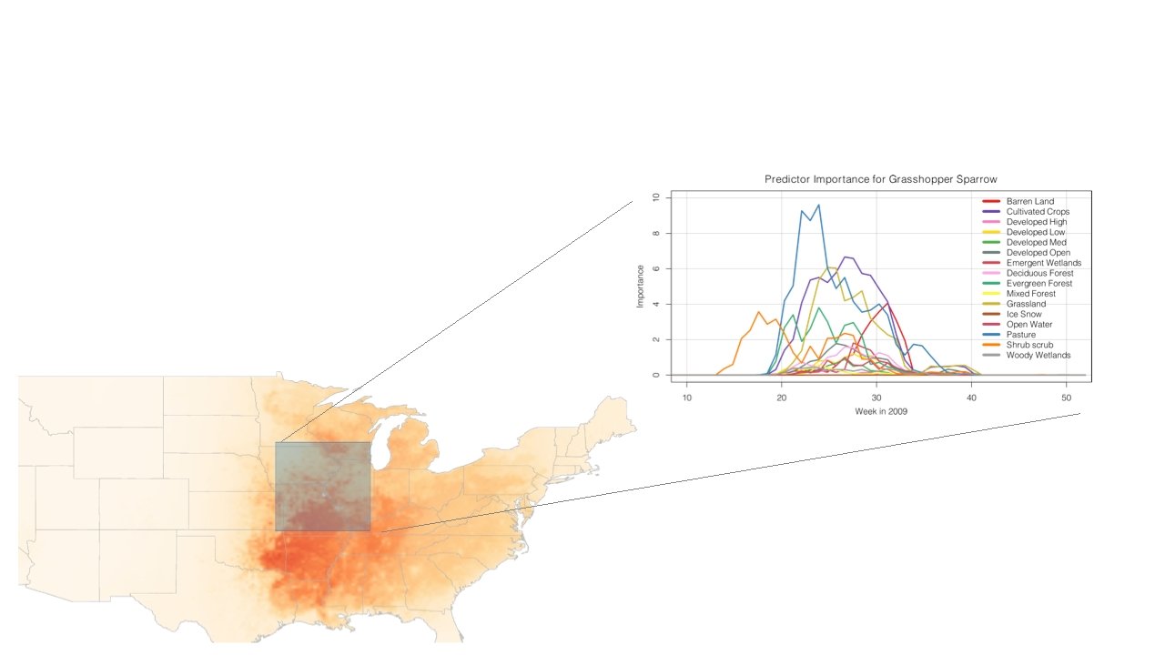
species location time STEM Model occurrence probability predictor importance
 occurrence")
species location time STEM Model Predictions for 2009 52 Predictions (one per week) occurrence probability predictor importance Barren Land Evergreen Forest Cultivated Crops Grassland Deciduous Forest Ice Snow Developed High Mixed Forest Developed Low Open Water Developed Med Pasture Developed Open Shrub scrub Emergent Wetlands Woody Wetlands habitat preferences

Biologists Statisticians Model Observation Data Results

Tarefas

Visualization Needs • • • Visualize migration patterns (What is the path birds follow? ) Compare the behavior of different species Investigate predicted habitat preferences (Are model habitat preferences corresponding to prior knowledge? )


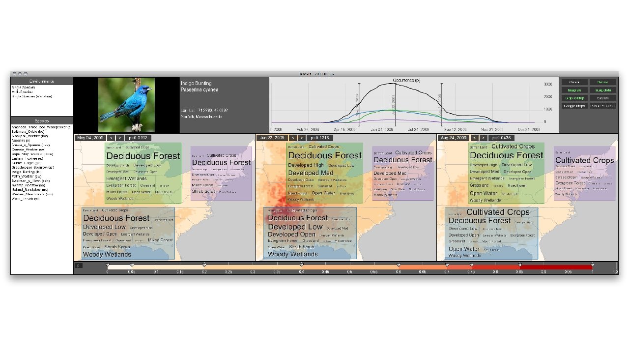
• • • Interactive visualization tool spatiotemporal multivariate data Collaboration with Cornell Lab of Ornithology Developed closely with Biologists and Statisticians

O Sistema

Design Decisions

Design Decisions Multiple Map Views

Design Decisions Colormap Controller

Design Decisions Example of Different Colormap Configurations

Design Decisions Visualizing Changes A + B = C C + D = E

Putting all together

Palm Warbler Spring Migration

Predicted Habitat Preferences Tag Cloud Lenses

Tag Cloud Lenses
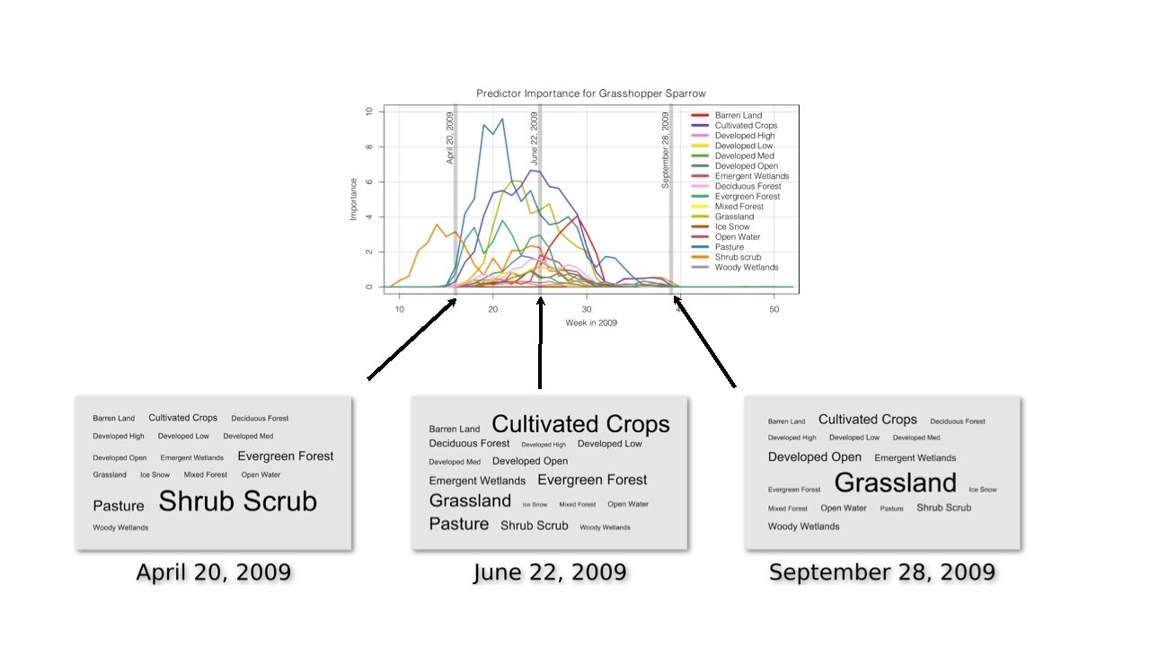

Tag Cloud + Magic Lenses + Coordinated Views = Tag Cloud Lenses

Tag Cloud Lenses Spatial Exploration

Tag Cloud Lenses Spatiotemporal Exploration

Visualizing Multiple Species

Multiple Species

Data Storage

Results • Please find attached a screenshot of Bird. Vis showing the fall migration of Baltimore Oriole that got me so excited… Bird. Vis exploration seems to make you wonder if the eastern birds are flying over the Atlantic to the Caribbean and FL? while the central population heads due south to Central America. Pretty cool, since this is the first bird I looked at.

Results

Results This is really cool. We should do a systematic search for this pattern in other species. My prediction is that it will crop up time and time again for species traditionally thought to be "Trans Gulf" that actually have a "Trans-Atlantic" component too. I think we could do a really great paper on this topic alone. . . I think we can make a strong case using observational data alone that this is a pattern shown by much more than just Blackpoll Warbler (which some skeptics still do not believe). Exciting!
- Slides: 53