Bergeron Air Mass Classification continental Arctic c A
 is an extreme version of c.")
Bergeron Air Mass Classification continental Arctic (c. A) is an extreme version of c. P Humidity Temperature LOW HIGH LOW continental Polar continental Tropical HIGH maritime Polar maritime Tropical
 (Pacific) m. T")
m. P c. P m. P (Atlantic) (Pacific) m. T

North America Air Masses and Source Regions
: • Air masses are large bodies of air with")
Quick Summary—Air Masses (Chapter 11): • Air masses are large bodies of air with consistent temperature and humidity, as characterized by their source region. • Main air mass types: c. P (cold, dry, polar land), c. T (hot, dry, subtropical land), m. P (cool, moist, high latitude ocean), m. T (warm, moist, low latitude ocean) • The U. S. is dominated by c. P in the winter and m. T in the summer. • Air masses can modify as they move out of their source regions and alter their thermal and moisture properties.
")
FRONTS (Chapter 11, pp. 306– 319)

Fronts occur in the boundary zone between polar and tropical air masses.

World War I Aerial Photograph “No man’s land” trenches

 500 mb Boston Philadelphia L L")
Ben Franklin’s Storm (Nov. 2, 1743) 500 mb Boston Philadelphia L L
 (map view) (looking north) up")
Air Mass Moving Out of Source Region (vertical cross-section) (map view) (looking north) up c. P w H (c. P) c w c. P w c w
 is shallower cold")
Friction Distorts Shape warm cold friction warm Trailing edge (warm front) is shallower cold warm Leading edge (cold front) is steeper (scale is greatly exaggerated for demonstration purposes)
 existing front c or w c w 2) wave (kink)")
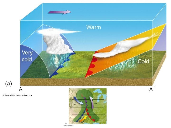
Norwegian Cyclone Model 1) existing front c or w c w 2) wave (kink) develops along the front c c w w a) Wave is linked to an upper-air disturbance (outside of scope of this class) b) Note northward advance of warm air in a small region c) Wind pattern is comparable to cyclone
 Open wave and warm sector formation c a) A low")
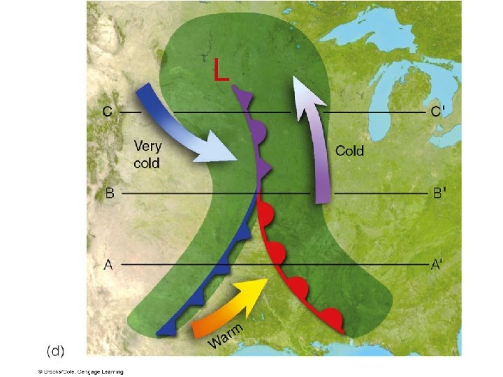
Norwegian Cyclone Model 3) Open wave and warm sector formation c a) A low (cyclone) forms in the original location of the wave L c w w b) Cold fronts move faster than warm fronts (15– 25 knots vs. 10 knots) (friction…two slides back!) 4) Initial occlusion L c c w the cold front has now caught up to the warm front, just southeast of the low
 final occlusion c L c w a) the occluded front")
Norwegian Cyclone Model 5) final occlusion c L c w a) the occluded front becomes larger b) because an occluded front is no longer a boundary between two air masses with much different temperatures, it represents the death of the system It’s important to realize that these fronts are not staying in place. They are moving as the system progresses through these different stages, usually from west to east (or more typically, from southwest to northeast)

Norwegian Cyclone Model polar/tropical air mass boundary waves form along fluid density boundaries cold front catches warm front warm air is pinched upward cold front moves faster than warm front storm dies (pp. 322– 324)

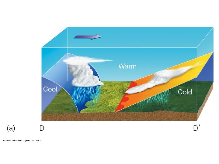
Typical Cold Front • Convective precipitation • 50– 100 mile wide band along front
 air wedges. Warm (often")
Cold Front Cross-Section Cold fronts are rapidly advancing cold (dense) air wedges. Warm (often moist) air is forced upward along and ahead of the surface front. Frontal slope is 1: 50 with a forward speed of 25 knots; 1: 100 at 15 knots.

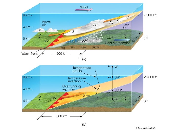
Typical Warm Front • Clouds and precipitation precede surface front • Stratiform clouds starting about 750 miles from front • Stratiform precipitation starting about 350 miles from front “Overrunning”
 750 miles Warm fronts are receding cold (dense) air")
Warm Front Cross-Section (350 miles) 750 miles Warm fronts are receding cold (dense) air wedges. Warm air gradually fills in the space vacated by the cold air. Frontal slopes are 1: 150 or 1: 200 for 10 knot forward movement.

Warm Front Cross-Section WARM AIR COLD AIR

Occluded Front


OCCLUDED FRONTS • Heavy precipitation along front • Convective or stratiform • Short duration
")
Occluded Front Cross-Section (“Cold Occlusion”)
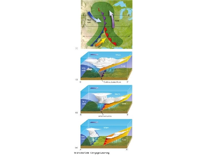

“Warm Occlusion”
")
Occluded Front Cross-Section (“Warm Occlusion”)

“Warm Occlusion”

Cold Occlusion coldest air is behind cold front Warm Occlusion coldest air is ahead of warm front
 STATIONARY FRONT Partly cloudy or cloudy with widespread stratiform precipitation")
(QUASI-) STATIONARY FRONT Partly cloudy or cloudy with widespread stratiform precipitation
")
Cyclone Family Cold Air Warm Air (pp. 306– 319)
: • Fronts are boundary zones between polar and tropical air")
Quick Summary—Fronts (Chapter 11): • Fronts are boundary zones between polar and tropical air masses. • Fronts are stable—the colder, denser air is close to the surface and warmer, less dense air is above it. • Cold front weather: cumuliform clouds, showery, convective precipitation along the front. • Warm front weather: stratiform clouds and precipitation in the cold air well ahead of the front. • Occluded front weather: very heavy precipitation of short duration in the vicinity of the front.

Graphical Summary of Fronts c w 50 w 00 – 1 c i. m 75 0 m i. 15– 25 kts. ; 1: 50 or 1: 100 slope c w Cs c 10 kts. ; 1: 150 or 1: 200 slope 35 0 m i. w Ns Ac cold w cool c c

How to Locate Fronts

How to Locate Fronts
 Low pressure front 2) Wind shifts H H 3)")
How to Locate Fronts 1) Low pressure front 2) Wind shifts H H 3) Clouds and precipitation (often provides clues to the type of front)
 Temperature and dew point contrasts (mostly c. P vs.")
How to Locate Fronts 4) Temperature and dew point contrasts (mostly c. P vs. m. T in the U. S. ; dew point is often a better guide than temperature) front c. P (cold, dry) m. T (warm, humid)
 Pressure change (tendency) since last observation Fronts are regions")
How to Locate Fronts 5) Pressure change (tendency) since last observation Fronts are regions of locally low pressure. The lowest pressure occurs the moment the front passes. This signal is especially strong in cold fronts. 04 00 96 96 L 00 04

Weather Changes with Passage of a Frontal System 08 12 04 08 A 00 L B C 12 D F STATION A B C D E F TEMP E DEW PT. P. TEND. CLOUDS WIND DIR PRECIP

Weather Changes with Passage of a Frontal System 08 12 04 08 A 00 L B C 12 D E F STATION TEMP DEW PT. A low B low, inc. C high D high E high F low, dec. P. TEND. CLOUDS WIND DIR PRECIP

Weather Changes with Passage of a Frontal System 08 12 04 08 A 00 L B C 12 D E F STATION TEMP DEW PT. A low B low, inc. C high D high E high F low, dec. P. TEND. CLOUDS WIND DIR PRECIP

Weather Changes with Passage of a Frontal System 08 12 04 08 A 00 L B C 12 D (A is 500 miles from front; B & D are 200 miles from front) E F STATION TEMP DEW PT. P. TEND. CLOUDS A low altocu B low, inc. nimbostrat C high fog? clring D high cu humilis E high cum. nim. F low, dec. Cb, clring WIND DIR PRECIP

Weather Changes with Passage of a Frontal System 08 12 04 08 A 00 L B C 12 D (A is 500 miles from front; B & D are 200 miles from front) E F STATION TEMP DEW PT. A low B P. TEND. CLOUDS WIND DIR PRECIP low altocu se low, inc. nimbostrat sse C high fog? clring sw D high cu humilis sw E high cum. nim. sw F low, dec. clearing nw

Weather Changes with Passage of a Frontal System 08 12 04 08 A 00 L B C 12 D (A is 500 miles from front; B & D are 200 miles from front) E F STATION TEMP DEW PT. A low B P. TEND. CLOUDS WIND DIR PRECIP low altocu se low, inc. nimbostrat sse C high fog? clring sw no D high cu humilis sw no E high cum. nim. wsw F low, dec. clearing ne no no? clring
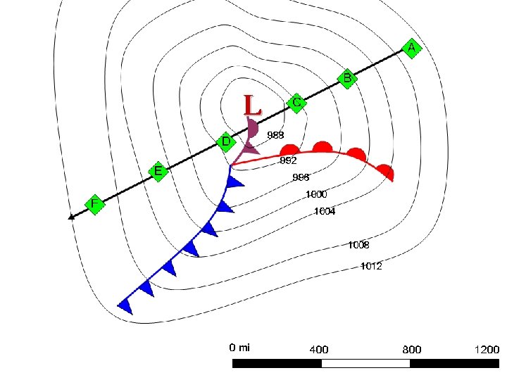
 A B C D E F SLP trend Cloud cover Wind")
Station Temp (low/high) A B C D E F SLP trend Cloud cover Wind direction Dew point Precip

Station Temp SLP trend CC Wind dir Dew point Precip A Low Falling Cirrostratus SE Moderate No B Low Falling Overcast, (nb)stratus SE Moderate No, chance light drizzle C Low Falling Overcast, nb SE -stratus Slightly higher Continuous rain D Lower Falling then nb-stratus rising or c-nimbus NW Slightly lower (? ) Mod-heavy rain showers E Lower Rising Clearing NW Lower No F Lower Rising No clouds NW Lower, stabilizing No
 c. P m. T")
c. P or m. P (Atlantic) c. P m. T

Clouds

Precipitation
- Slides: 54