BELL RINGER 22117 Create a circle map on

BELL RINGER 2/21/17 • Create a circle map on what you know about WEATHER

Unit 3 Air Masses and Severe Weather

Air Pressure & Wind • Air Pressure & Wind 2/21/2017
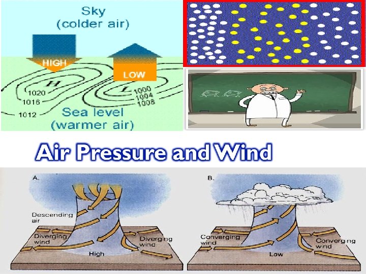

© Air pressure - the pressure exerted by the weight of air above © Exerted in all directions (up, down, and sideways) © Air pressure doesn’t just push down on an object, it pushes all around the object (High or low? )
 � inches")
� Barometer: device used for measuring air pressure � Unit: millibars (mb) � inches of mercury � Torricelli: invented the mercury barometer in 1643 � � https: //www. youtube. com/watch? v=GRxgl. LS 1 YWI

© The unequal heating of earth’s surface generates pressure differences © Solar radiation is the ultimate energy source for wind

� Isobars lines on a map that connect places of equal air pressure � A pressure gradient � The spacing of isobars shows the amount of pressure change over a given time �

�Closely spaced isobars: indicate a steep pressure gradient and high winds. �Widely spaced isobars: indicate a weak pressure gradient and light winds.

AKA Pressure Behavior Low Pressure Centers High Pressure Centers Cyclones Anti-cyclones Pressure drops Pressure increase Wind Behavior Winds blow counterclockwise Winds blow outward and clockwise Weather Associated Severe and stormy Fair and Sunny Symbol “L” that is RED “H” that is BLUE

�Wind is a result of horizontal differences in air pressure �Air flows from areas of high pressure to areas of lower pressure.

https: //www. youtube. com/watch? v=ai. Yy. Cu rh_SU

© © © Jet streams are fast-moving rivers of air Speed: 120 and 240 kilometers per hour Direction: West-to -east direction. © https: //www. youtube. com/watc h? v=WAve 9 Pl. K 4 Gg © https: //www. youtube. com/ watch? v=Cg. MWwx 7 Cll 4 https: //www. youtube. com/watch? v=huweoh. Ih_Bw

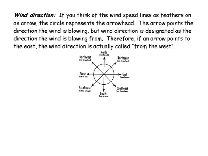
� Direction Labeled by the direction from which they blow � Ex: winds blowing from the Southeast. � Tool: Wind Vane �

� Anemometer � Measures how fast wind is blowing

Air Masses & Fronts • Air Masses & Fronts 2/22

Chapter 20 Air Masses

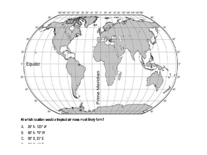
Probing Questions � Refer back to heating of land water activity � Now lets look at heating of land water on a global scale! (continental and maritime) � Go back to solar radiation. Warmer at the equator. (Tropical and Polar) at equator and poles.

Air Mass ❑An air mass is a big body of air that is characterized by similar temps and moisture ❑When an air mass moves out of the area it formed over, it keeps the same temp and moisture conditions ❑As it moves, the characteristics of an air mass change and so does the weather in the area it moves over

Classifying Air Masses �Air masses are classified by temperature and surface area over which they form

Classifying Air Masses NAME P – Polar T – Tropical LOCATION High Latitudes towards the poles Low Latitudes towards the equator TEMPERATURE Cold Temps Warm Temps C – Continental Over land mass Cold or warm, depending on the latitude M – Maritime Cold or warm, depending on the latitude Over water

Four Basic Types of Air Masses c. P – Continental Polar c. T – Continental Tropical • dry and cool • cold and dry in winter and summer • dry m. T – Maritime Tropical m. P – Maritime Polar • wet and warm • source of precipitation in the United States and warm • hot, drought-like conditions and cold • mild, humid, unstable cold air from Canada

Weather in North America is influenced by continental polar and maritime tropical air masses
 and the space")
Probing Questions Probe to get to that air masses move (wind) and the space between two air masses is the front.

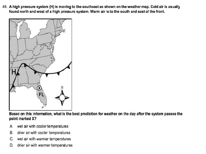
Fronts ●When two air masses meet ●boundary separating the two air masses.

Warm Front �A warm front – warm air moves into an area formerly covered by cooler air �Warm air glides up over a cold, dense air mass �Weather Conditions: Light to moderate rain

Cold Front Cold air mass moves into an area occupied by warmer air. Weather Conditions: Thunderstorms

Stationary and Occluded Fronts �stationary front: The surface position of the front does not move (steady rain for days) �occluded front: when an active cold front overtakes a warm front

Low Pressure Centers Low Pressure Cyclones Pressure drops High Pressure Centers High Pressure Anti-cyclones Pressure increase Wind Behavior Winds blow counterclockwise Winds blow outward and clockwise Weather Associated Severe and stormy Fair and Sunny Symbol “L” that is RED “H” that is BLUE Centers of AKA Pressure Behavior

Tornadoes & Thunderstorms • Tornadoes & Thunderstorms 2/23/2017

Severe Storms -Thunderstorms -Tornadoes -Hurricanes

Thunderstorms -Is a storm that generates thunder and lightning -Frequently produces gusty winds, heavy rain, and hail Associated with cumulonimbus clouds
")
Lightning: results from the build up and discharge of electric energy between positively (ground) and negatively (clouds) charged area -Thunder: the sound of rapidly expanding gases usually associated with lightning https: //www. youtube. com/watch? v=G 7 Gb. OFl. FODE https: //www. youtube. com/watch? v=j. M 8 h 60 S 1 Gs. M

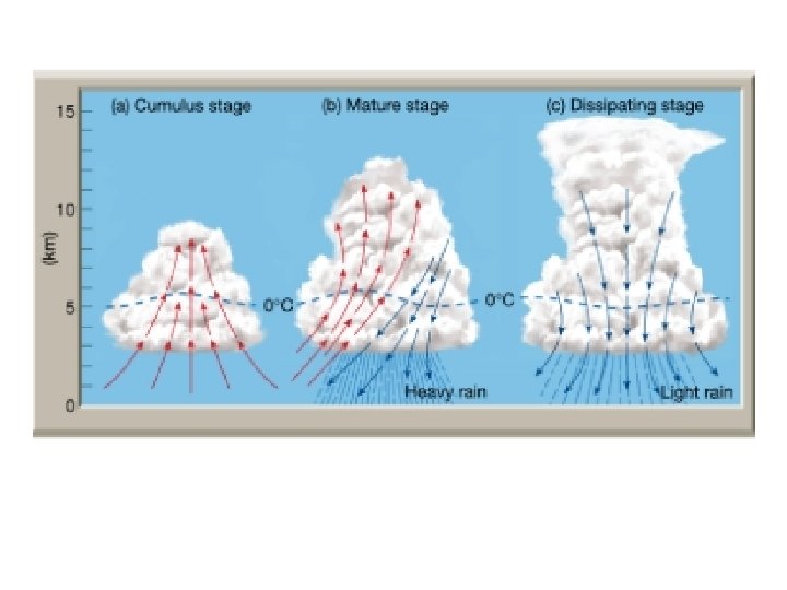
Occurrence and Development • Occurrence • At any given time, there an estimated 2000 thunderstorms in progress on Earth • Mostly in the tropics • Development • Thunderstorms form when warm, humid air rises in an unstable environment • 3 Stages

3 Stages • Cumulus: build up of clouds and moisture • Mature: Heavy rainfall, most active time • Dissipating: light rain, storm is calming down

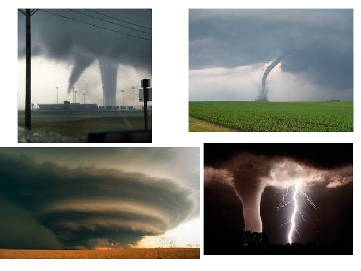
Tornadoes �Tornadoes - violent low pressure windstorms that take the form of a rotating column of air (vortex). �The vortex extends downward from a cumulonimbus cloud producing rain and hail �Move counterclockwise https: //www. youtube. com/watch? v=o. QPBj. QHG 8 gc https: //www. youtube. com/watch? v=V-Xbj 0 a. Ek. RQ

Occurrence, Development, and Intensity of Tornadoes �Occurrence � 770 occur each year � Tornado Season �April to June �Associated with severe thunderstorms �Intensity �Fujita Tornado scale �Based on the amount of damage
 Winds (KPH) Damage F 0 <73 <116 Light")
Fujita Tornado Scale Category Winds (MPH) Winds (KPH) Damage F 0 <73 <116 Light damage F 1 73 -112 116 -180 Moderate Damage F 2 113 -157 181 -254 Considerable Damage F 3 158 -206 254 -332 Severe Damage F 4 207 -260 333 -419 Devastating Damage F 5 >260 >419 Incredible and Speechless Damage

Tornado Warnings vs. Watches �Watches : Possibility of a tornado to be developed in the area �Warning: Tornado has been seen by people or indicated by radar

Hurricanes 2/24/2017 • HURRICANES
 producing winds of at least 119 km")
Hurricanes �Whirling tropical cyclones (low pressure system) producing winds of at least 119 km per hour (73 mph) �US – Hurricanes �Pacific – Typhoons �Indian Ocean – Cyclones �Most powerful storm on Earth

Occurrence and Development of Hurricanes Occurrence �Form between 5 and 20 degrees north and south latitude �Season: June 1 to November 30 th Development of Hurricanes �Hurricane develop most often in the late summer when water temperatures are warm enough to provide the necessary heat and moisture to the air �Low Pressure: Spins counterclockwise

Parts of a Hurricane Eye: Center of storm, warmest part, winds cease, rain ceases Eye wall: Strongest winds and rain Spiral Rain Bands: extend out from the eye wall https: //www. youtube. com/w atch? v=Wk_FVXVn. E 2 I

Hurricane Intensity �Storm Surge: is a dome of water that sweep across the coast caused by the hurricane’s winds �Categorized on the Saffir. Simpson Scale (based on wind speed)

Hurricane Warning and Watches �Hurricane Watch: could see hurricane related hazards within 48 hours �Hurricane Warning: Could see hurricane winds within 36 hours

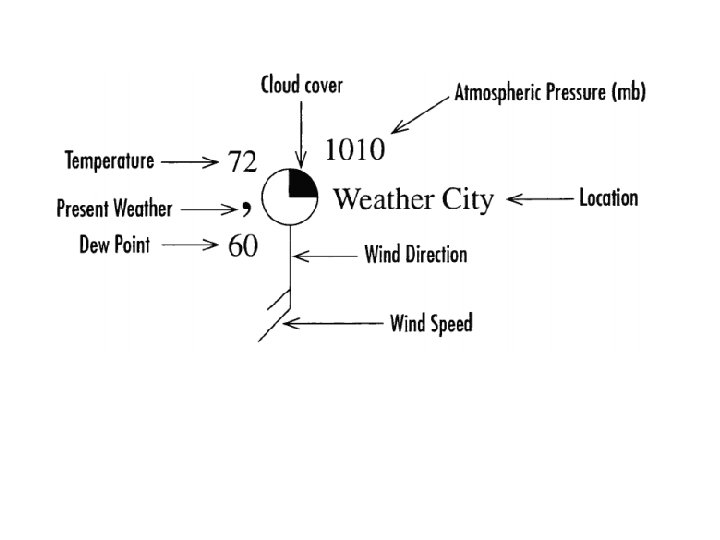
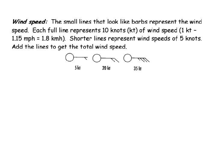
Weather Symbols
- Slides: 56