B Sc Nautical Science Semester IV MeteorologyII Oceanography
 Unit-2 Oceanic Waves and")
B. Sc. Nautical Science Semester IV • • Meteorology-II (Oceanography) Unit-2 Oceanic Waves and Tides By Capt. K. Kumar
 The")
Objectives • At the end of this lesson the students should understand: 1) The concept of Wave formation, its speed, length, period & height and significance; 2) The fundamental difference between the Wave and Swell, types of waves and their behavior in deep and shallow water; 3) The transformation of Waves into Surf, Storm surge, Tsunami waves and Bore tides; 4) The forces which produce Tides and type of Tides, their prediction and analysis, relationship between tides and Phases of Moon; and 5) What are Tidal streams and interpretation of Tidal charts.

Speed, Length, Period, Height and significance of waves: • Wind Waves – The name “wind wave” is the name given to any wave that is created by the wind blowing over the ocean surface. In this case, the disturbing force is the energy transferred from the wind to the ocean surface. The ocean will carry this energy in the form of waves eventually releasing it along a shoreline. The size of wind wave will depend on three main factors: (1) the wind strength, (2) the wind duration, and (3) the uninterrupted distance over which the wind blows. • Wind waves are the most common type of wave in the ocean and are found superimposed on currents, tides, and tsunami. Wind waves are also common in other bodies of water like lakes, ponds and rivers. The larger the body of water, the bigger the wave we might expect to see. For example, Lake Superior of the Great Lakes of North America often has very large waves due to its orientation parallel to the prevailing winds.
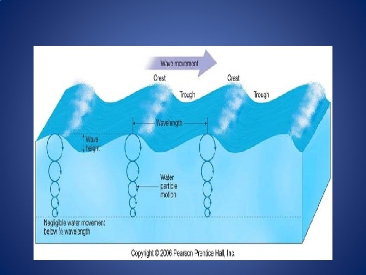

• Ocean waves have several distinct parts as diagrammed in the figure above: • The wave crest is the highest part of the wave above average water level • The wave trough is the lowest part of the wave below average water level • Wave height is the vertical distance from trough to crest • Wavelength is the horizontal distance between two successive wave crests • In addition to these parts, we can also describe wave movement using several characteristics: • Wave period is the time it takes for a wave to move a distance of one wavelength (expressed in seconds or minutes) • Wave frequency is the number of wave crests passing a fixed point per second (expressed in terms of number/time) • Wave speed is calculated by dividing the wavelength by the wave period (expressed in distance/unit time) • Wave steepness is equal to the ratio of the wave height over the wavelength.

Waves represent the oscillatory motions of the ocean surface induced by the force of the wind. • The movement of energy from water particle to water particle takes place in circular paths. Therefore, water particles pass energy along to one another by rotating in a circle in the direction of the energy movement. Most of the time, the energy that is transferred to the water by wind (or another force) can be carried long distances with little or no change. In addition to passing energy forward, the movement of the water particles also transmits energy downward to deeper parts of the ocean. However, that energy dissipates (decreases) with depth due to friction and other forces. And at a certain depth, generally a distance ½ the wavelength, the orbital motion of water particle ceases completely. The depth below which no orbital motion occurs is called wave base. • Waves in the oceans can travel thousands of miles before reaching land. Wind waves range in size from small ripples, to waves over 100 ft (30 m) high. • Difference between Sea Waves and Swell-When directly generated and affected by local winds, a wind wave system is called a wind sea wave. After the wind ceases to blow, wind waves are called swells. More generally, a swell consists of wind-generated waves that are not significantly affected by the local wind at that time. They have been generated elsewhere or some time ago. Wind waves in the ocean are called ocean surface waves.

Waves in the open ocean

• Types of Waves- In the open ocean, waves have a wave base that is less than the water depth – there is a depth at which orbital motion no longer exists. In shallow water, wave orbital's interact with the seafloor, therefore the entire water depth experiences orbital motion. • When waves travel in water deeper than their wave base their orbits are circular and wave speed is determined by wavelength. Behaviour of Waves in Deep and Shallow Waters. Most wind waves in the open ocean behave as deep water waves, meaning that they move through water that is deeper than ½ their wavelength (wave base). The speed of a deep water wave is mostly dependent upon wavelength – the longer the wavelength, the faster the wave. Most wind waves are formed out in the open ocean as prevailing winds or storm winds blow over an area. The place waves are first formed is called sea. Within sea, waves are often chaotic, moving in different directions and having different sizes. Fully developed sea is defined as the maximum wave size that can be produced given a certain wind speed, duration and fetch. (area over which the wind is blowing).

• Eventually, similarly sized waves will group together and leave their area of origin. Once the waves leave, they become swell – a series of waves of similar size and fairly constant wavelength that travel away from their disturbing force. These waves travel in groups called wave trains for long distances across the open ocean. Over their travel they retain the energy that formed them with little loss. Generally, the largest and fastest waves from sea move out first, then the smaller waves follow – they are naturally sorted by size and thus speed.

Sea Waves, Swell, Storm Surges, Tsunami • Because waves can form in any given place in the ocean due to a variety of factors, we might expect that wave trains will frequently “bump” into each other. This is called interference and can have dramatic (and some not so dramatic) results. Waves can combine in -phase (wavelength to wavelength) and create even larger waves through constructive interference. Waves can also collide out-ofphase (wavelength to trough) and make smaller waves or “cancel out” completely through destructive interference. • However, in most cases waves do not come together exactly inphase or out-of-phase because this would require each train to be made of the same wavelength wave and meet exactly parallel to one another. Often, we find mixed interference, where several wave trains traveling different directions and having different sized waves combine - creating some larger waves and some smaller waves. In extreme cases, the wave’s trains’ interference can create one or more exceptionally large waves – called rouge waves. Although a rare occurrence, ocean-going vessels occasionally experience Rogue waves.

Waves in shallow water

• Shallow water waves interact with the seafloor because their wave base is greater than the water depth. Speed in shallow water waves is controlled by water depth. • When the base of a wave begins to interact with the seafloor, we say that a wave is behaving as a shallow water wave. Deep water waves become shallow water waves as they approach a shoreline. Other very long wavelength waves, like tsunami and tides, act as shallow water waves even in very deep waters – their orbital motion always interacts with the seafloor. Speed in shallow water waves is directly influenced by water depth – the shallower the water, the more the wave is slowed. • As a wave train (swell) approaches shore, several changes take place to alter the shape of the wave. These changes are: • When the wave train reaches a water depth that is less than onehalf the wavelength the wave begins to “feel” bottom • The orbital motion of water particles becomes interrupted as they encounter friction with the seafloor – the Orbital’s near the bottom part of the wave begin to flatten out to an Oval shape • Interaction with the bottom slows the wave down, and the wavelength becomes shorter as the waves “bunch up
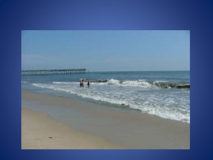

• Waves release their energy onshore in an area called the surf zone. Do you see evidence in this image for wave refraction? • the amount of energy in the wave remains the same, so the energy that was in the wavelength transfers to height and steepness • The top part of the wave still experiences orbital motion and will move faster than the bottom part of the wave • The wave breaks on the shore when its height and upper speed become too great • The breaking of waves on the shore is called Surf and the area where it occurs is called the Surf Zone. Waves will break on the shore in different ways depending on the shape of the seafloor. These differences are described in terms of plunging, spilling and surging breakers. It is in the surf zone that waves release the energy originally stored from its creation in the open ocean. In the “Coasts” module, we will discuss the erosive effects of this energy release. • Just as wave trains travel in all different directions in the open ocean, waves also approach the shore in different directions. Refraction is a term used to describe waves that approach the shore at an angle. When this happens, the line of waves does not break at the same time because different parts of the wave experience varying depths of water. This creates a “bending” of the wave train as the parts of the wave in shallow water slow down first.

Other types of ocean waves • Up to this point, we’ve been discussing the most common type of wave – those generated by wind. It is important to note that waves in the ocean can be formed from other disturbing forces. Below, we briefly discuss these other waves. • Internal Waves. Internal waves are waves that travel within the ocean, not on the surface. Most often, these waves occur between layers of water with different densities. Internal waves can be caused by tidal forces, ship wake, strong winds and small earthquakes. Internal waves can be immense and potentially damaging to oil rigs, submarines and other within-ocean operations. Because these waves operate within the water column, they may not be easily observed. However, some of the best visuals of internal waves come from satellite imagery where sunlight highlights the waves. Scientists are currently researching the effects of internal waves on mixing ocean water and transferring energy.
 is a standing wave that can occur")
Seiche Wave • A seiche (pronounced saysh) is a standing wave that can occur in any enclosed body of water. A standing wave is different than the waves we’ve discussed because it does not move forward; rather, it oscillates (moves back and forth) similar to sloshing water around in a tub. Seiche waves are observed regularly in bays, reservoirs, lakes, seas and even swimming pools. The wave is caused by any force that acts to resonate (vibrate) the water – forces like winds, earthquakes, tides or tsunami. Lake Erie, of the Great Lakes, is very susceptible to seiche due to its orientation relative to the prevailing winds. The winds will push water to one side of the lake, setting it into a rocking motion that can last for hours or days.

Storm Surges and Tsunami • A storm surge is a rise in sea level above normal tidal variations due to the action of strong winds blowing towards the land. When storm surges are the result of severe storms such as hurricanes, the low atmospheric pressure at the center of the depression can additionally raise the sea level. • Thus storm surges are usually the result of two different physical processes, namely wind shear stress acting on the water surface and changes in the atmospheric pressure. Storm surges have been responsible for extensive flooding of low-lying regions in many parts of the world, and have caused great loss of lives and property damage. • Storm surges can be more severe if they coincide with a high tide or if they bracket several tidal cycles, particularly in the case of a Perigean tide. The term storm tide is used by some researchers to denote the sum of the astronomical tide and storm surge.

• Tsunami- Large underwater earthquakes and landslides can create huge waves called tsunami. Tsunami can be very large, very fast and very destructive shallow water waves. These waves are most common in and around the Pacific and Indian Oceans due to tectonic activities. Tsunamis are low-frequency ocean waves generated by submarine earthquakes. The sudden motion of seafloor over distances of a hundred or more kilometers generates waves with periods of around 12 minutes (Figure 17. 7). A quick calculation shows that such waves must be shallowwater waves, propagating at a speed of 180 m/s and having a wavelength of 130 km in water 3. 6 km deep (Figure below). The waves are noticeable at sea, but after slowing on approach to the coast, and after refraction by subsea features, they can come ashore and surge to heights ten or more meters above sea level. In an extreme example, the Alaskan tsunami on 1 April 1946 destroyed the Scotch Cap lighthouse 31 m above sea level.
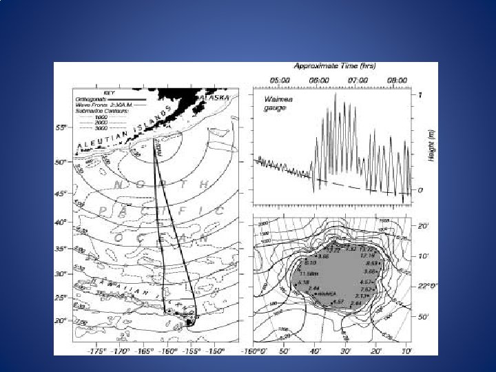

• The influence of tsunamis based on past studies in the Pacific can be summarized as under: • Tsunamis appear to be produced by movement (an earthquake) along a linear fault. • Tsunamis can travel thousands of kilometers and still do serious damage. • The first wave of a tsunami is not likely to be the biggest. • Wave amplitudes are relatively large shoreward of submarine ridges. They are relatively low shoreward of submarine valleys, provided the features extend into deep water. • Wave amplitudes are decreased by the presence of coral reefs bordering the coast. • Some bays have a funneling effect, but long estuaries attenuate waves. • Waves can bend around circular islands without great loss of energy, but they are considerably smaller on the backsides of elongated, angular islands.

Destructive Waves • Waves caused by local winds are all high relative to their lengths. though they differ greatly in size and characteristics. The orbital velocity of water particles is great, but the speed is low. The plunge of such waves is almost vertical, so much energy is lost in the process besides being consumed by the eddies or rollers as they, advance up the beach. Although the upcoming “The Send” is weak, it transports a considerable volume of water up the beach. The same water returns as a relatively powerful “Backlash”. As this meets the oncoming ‘Send’ it reduces its effect. As a result of this these sea waves tend to drag materials down the beach towards the open ocean. These waves are called “Destructive Waves”. Destructive waves fall into two categories- i) ‘Seismic or Tsunami Waves’ and ii) ‘Storm Waves/Surges’. Tsunami waves are called seismic waves as they are produced by the submarine earthquakes. The wavelength of the Tsunamis may be as long as 160 Km and such waves travels at a very high speed, sometimes reaching 650 Km or more per hour. However in the open sea their height hardly exceeds 1 meter, but when they travel in shallow coastal waters, they may develop into waves having abnormal height, causing unimaginable damage/destruction in a very short period of time. Storm waves caused by Hurricanes and other local storms prove very disastrous. The waves of extraordinary height produced by these storms play havoc, particularly in the low lying coastal areas. Actually they involve huge loss of life and property in the coastal zone.

Ocean Tides, Tide Producing forces & Types of Tides • Theory of Ocean Tides- Tides have been so important for commerce and science for so many thousands of years that tides have entered our everyday language: ‘time and tide wait for no one’, ‘the ebb and flow of events’, ‘a high-water mark’, and’ turn the tide of battle’. • Tides are defined as a rhythmic rise and fall of the sea-level under the influence of changing attractive forces of the Sun and the Moon on the rotating Earth. The tides are an extreme example of shallow water waves whose velocity is proportional to the square root of the water depth. When the sea level under the influence of Solar and Lunar attraction, is raised it is called ‘High Tide’. Conversely when the sea level falls, the ‘Low Tide’ occurs. In the open sea the difference in the height between the high and low tides is known as ‘Tidal Range’. The time interval between the two high tides is called the ‘Tidal Interval’. When due to tides , horizontal currents are generated in a Bay or Inlet, they are known as ‘Tidal Currents’. The Tidal currents heading towards the coast are called ‘Flood Tide’, and those returning from the coast towards the sea are known as ‘Ebb Tide’.

Type of Tides and Tide Producing forces • When there are two high tides and two low tides during each Solar day, occurring approximately every 12 hours, each tide being at the same level. Such tides are known as Semi-Diurnal tides. Over much of the Pacific and Indian oceans there also two high and two low tides in a Solar day. However their amplitudes are different, either of high tides is not equal. Such a type of tide is known as Mixed Tide. In certain areas, like Gulf of Mexico, the adjacent seas around the Philippines Islands, the coastal areas of Alaska and the seas near the coast of China, there is only one High Tide and one low tide during each 24 hours. Such tides are known as Diurnal Tides. • Tide Producing forces- Tides actually represent the vertical motion of the sea water under the influence of the Gravitational forces. The law of Gravitation states that every particle of mass in the Universe attracts every other particle of mass with a force that is proportional to the product of their masses and inversely proportional to the square of the distance between the masses. While the Tide Generating force is inversely proportional to the cube of the distance between the masses.

Fig 13. 1 Common centre of gravity of the revolution of the Earth and Moon
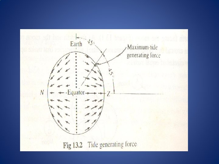

• Gravitational Force= M¹ x M²/ R², and Tide Generating Force= M¹ x M²/ R³ • The Sun is 27 million times more massive than the moon but the Sun is 390 times further away from the Earth than the Moon. Hence the Sun’s tide producing force is about 46% that of the Moon. The tides generated in the oceans is the result of the rotation of the Earth and the Moon about their common centre of mass which is about 4700 Km away from the Earth’s center. Actually this common center is located 300 m below the Earth’s surface facing the Moon. As the Earth and the Moon rotate as a system around this point all particles that make up the Earth follow circles of equal radios. The Gravitational attraction of the Moon is greatest for particles closer to the Moon, and is directed towards the center of the Moon. The Sun and other planets too are the source of a tide generating force. However the moon has the maximum tide-producing force on the Earth’s surface. The tide generating force is given by the difference between the forces of mass attraction (centripetal force acting on mass particles on Earth’s surface) and the centrifugal force (due to rotation of Earth on it’s axis). The system of tide generating forces will differ in accordance with the changing distances between the Earth and the Heavenly bodies. These variations account for the inequalities in the tidal phenomenon.
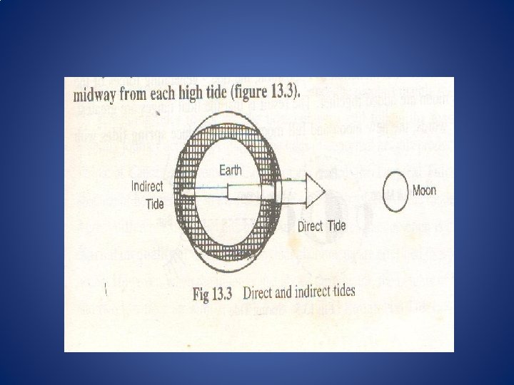

• The centrifugal force causes the Earth and the Moon to have a tendency to fly away from each other. But the centrifugal force is exactly balanced by the gravitational attraction (centripetal force). On the side of the Earth, closest to the moon, the Moon’s gravitational attraction is stronger than the average, also stronger than the centrifugal force derived from the Earth-Moon system. The ocean waters on the side of the Earth facing the Moon, under the impact of the stronger gravitational force bulge towards the Moon. This is called Direct Tide. The bulge of water is directly opposite to that produced by the centrifugal force. The Earth rotates through this bulge produced by the centrifugal force once each day. This bulge of water is called the Indirect Tide. Thus there are two high tides daily. Since they are 180° of Longitude apart, they are separated by 12 hours. Between these two bulges the waters recede as they are pulled towards the areas of high tides. Accordingly there is a Low Tide midway from each High Tide.

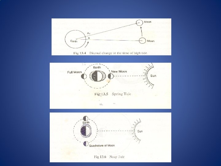
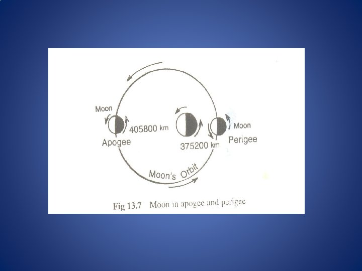
Declinational Tides, Apogean and Perigean Tides • The Earth’s axis of rotation is tilted 23½° to the plane of its orbit about the Sun. The Moon’s orbit is at an angle of 5° to the plane of the Earth’s orbit around the Sun. Hence the maximum declination of the Moon relative to the Earth’s Equator varies from 18½° to 28½° to the north or south of it. Since the Moon is mainly responsible for generating tides in the oceans, the tidal bulges would follow the Moon on it’s monthly journey across the Equator. The ides of abnormal heights produced at the Tropics of cancer and Tropics of Capricorn are called the Tropical Tides. When the Moon is just above the Equator, the heights of two high and two low tides are similar. Such tides are called Equatorial Tides. • Apogean and Perigean Tides- When the distance between the Earth and the Moon is minimum, the Moon is said to be in Perigee and this distance is about 375200 Km. When the Moon is at its farthest distance of about 405800 Km, it is said to be in Apogee. Since the tide generating forces are inversely proportional to the cube of he distance from the center of the Earth to the center of the tide generating object, in this case the Moon, the Perigee Tides are about 20% higher than the average tides and the Apogee Tides are 20% lower than the average.

Tide Prediction and Analysis, Relationship between Tides and Phases of Moon: • Mariners have known for at least four thousand years that tides are related to the phase of the moon. The exact relationship, however, is hidden behind many complicating factors, and some of the greatest scientific minds of the last four centuries worked to understand, calculate, and predict tides. Despite all their work important questions remained: What is the amplitude and phase of the tides at any place on the ocean or along the coast? What is the speed and direction of tidal currents? What is the shape of the tides on the ocean? Where is tidal energy dissipated? Finding answers to these simple questions is difficult, and the first, accurate, global maps of deep-sea tides were only published in 1994 (Le Provost et al. , 1994). The problem is hard because the tides are a selfgravitating, near-resonant, sloshing of water in rotating, elastic, ocean basin with ridges, mountains, and submarine basins. Predicting tides along coasts and at ports is much simpler. Data from a tide gauge plus theory of tidal forcing gives an accurate description of tides near the tide gauge.

Combined Effects of Sun and Moon on Tides • When the Sun and Moon are either in conjunction or opposition, the tide generating forces of the Sun and Moon are added together. The result is that the Tidal ranges are greatest. In other words, the New Moon and the Full Moon phases produce “Spring Tides” with maximum tidal ranges, the vertical difference between high and low tide. When the Moon is in the Quadrature, is at right angles to the Sun relative to the Earth. During the Quadrature phase “Neap Tides” are produced with minimal tidal ranges. Because the tidal bulge created by the Moon is at right angles to the bulge created by the Sun and thus the bilges tend to cancel each other, resulting in smaller bulge.

Tidal Streams/Currents • In the shallow waters of the Continental Shelf the tidal currents of different types are caused by the tides generated in the open oceans. In fact the tides and the tidal currents are two manifestations of he same process. There is very close connection between them. Tidal currents generally represent two dimensional processes whereas tides are one dimensional. In a tidal wave the water particles move only to and fro, but when under favourable conditions tide producing forces produce the horizontal flow in water, is called the Tidal Current. At the time of the High Tide on-shore tidal currents are produced, whereas at the time of low tide (Ebb tide) the tidal currents move in the opposite direction i. e. towards the sea. The tidal currents are influenced by bottom relief, depth of water, the width of the Continental Shelf, friction, the rotation of Earth and the density stratification. The tidal currents produced in Estuaries and rivers are dependent on the tides of sea and nature of the Coastline. The tidal currents near the shore and in shallow waters have great powers to transport material. In shallow waters on-shore waves stir up material lying on the bottom and this is then picked up and moved laterally by the tidal currents. Tidal currents influence the speed of the ships and other crafts relative to the ground. Tremendous amount of energy is associated with tidal currents. Attempts are being made to harness tidal energy technologically. The tidal currents build up sand waves on the sea floor which are 0. 5 to 2. 0 meters high and 30 to 50 meters long thus bring about a change in the bottom relief of the oceans which, in turn, influences the sea waves. Thus the coastal morphology is largely affected.
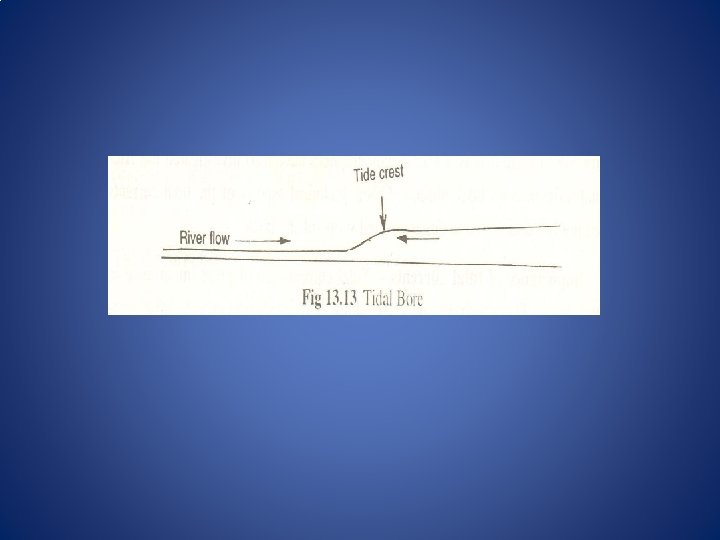
 • The River water, if it is in the larger")
Tidal Bore (Bore Tides) • The River water, if it is in the larger volume, presents hurdles in the progress of the tidal wave upstream. . Thus in the narrow and shallow channel of the river, the tidal wave gains abnormal height. . The front part of such a tidal wave which has grown in height stands as a wall, while the backwater assumes an elongated shape. These tidal waves are, therefore, called a “Tidal Bore”. Due to these high waves the direction of flow is reversed to a certain distance. With the further movement of the tidal bore upstream there is a continuous decrease in its height due to friction with the bottom of the River channel until it finally dies out. The great difference in elevation between the sea level in the estuary mouth and the floor of the estuary higher up causes the water to break into a wave with foaming crest, which rushes up the estuary very rapidly. The height of the bore is varied in accordance with the tide in the Bay. The maximum development of a bore occurs at the time of the Spring Tide. Some Rivers in China, like Tsien-tang Kiang river in North China, the front of the bore tidal wave is 3 meters high and it’s rate of upstream advance is 16 Km an hour. In India, the tidal bore occurs in Hooghly River during the period of exceptional Spring Tide.

Co-Tidal Charts and interpretation of Tidal charts • The modern concept known as the oscillatory or stationary theory implies that the ocean surfaces can be divided into ‘Tidal Units’. Each unit has a node or a center. In certain units there may be two nodes, which is known as ‘Bi-nodal System’. The shape size and depth of the waters within one of these tidal units have considerable influence on the pattern of co-tidal lines. In each oscillating area, the amount of oscillation differs with changes in the relative positions of the Sun, moon and earth together with a gyratory movement produced by the rotation of the Earth. The diurnal rotation of the Earth gives a gyratory motion to the rocking of he standing wave which swings around a point, known as an amphidromic point. , rather than oscillate about a nodal line. Modern maps have been drawn in which a series of nodal points (amphidromic points) have been located.

• It is from these amphidromic points that co-tidal lines radiate. In the North sea one such amphidromic point occurs which is almost equidistant from East Anglia and the Netherlands. Another amphidromic pint is located in the North Channel of the Irish Sea. • Interpretation of Co-tidal lines on Charts: • Indicating coincidence of high tides or low tides. • Relating to a line that passes through each location on a coastal map where tides occur at the same time of day. Cotidal maps show variation in the height of the tides and indicate the time of high tide occurrence. Co-tidal charts can be made using tide gauge data from gauges at regular intervals along the coast; however, computer modeling is increasingly used, especially where the tides vary greatly over a short distance. _________
- Slides: 38