Autonomous Vehicle Sensors V 2 V and Uncertainty


 Aerially-captured LIDAR map Moon")


 • Used in ACC")

 • Cheap")


- Slides: 56
Autonomous Vehicle: Sensors, V 2 V, and Uncertainty COMP 790 -058 Multi-Agent Simulation for Crowds and Autonomous Driving Presenter: Shiwei Fang
Outline • Sensors • V 2 V • Uncertainty
Refresh
Sensors Voyage
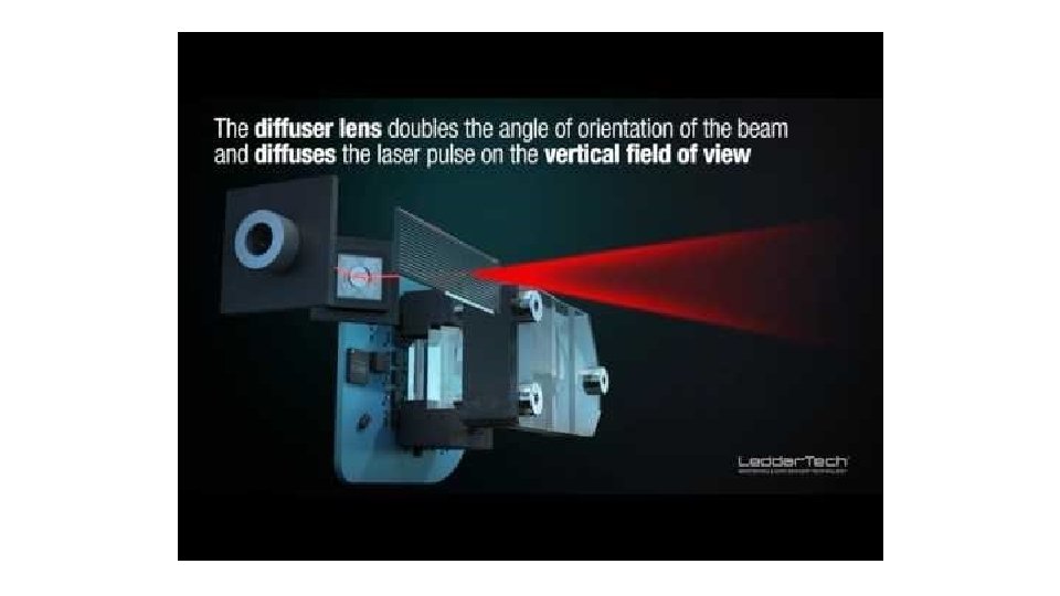
LIDAR • Light Detection and Ranging • Sometimes: Light Imaging, Detection, And Ranging
How it works • Emit laser and receive the reflection • Time of flight Time-to-Digital Converter (55 ps)
Types • Mechanical • Solid-State
Types • Mechanical • • • Most common one right now Rotate the sensor to get 360 degree view Multiple beams to cover vertical field of view High Cost ~$80, 000 Large in size • Solid-State
Most mount the major one on top of the vehicle. And mount the smaller one on side and etc.
Types • Mechanical • Solid-State • • No mechanical part More robust Saving in cost (sub $500 target) Only a limited filed of view
Limitations • Heavy fog, rain, snow… • Angle resolution • Google Waymo: long range LIDAR, short range LIDAR • Need to be in line of sight • Does not work with glass • Nor mirror
Safety • Interference between multiple LIDAR G. Kim, J. Eom and Y. Park, "Investigation on the occurrence of mutual interference between pulsed terrestrial LIDAR scanners, " 2015 IEEE Intelligent Vehicles Symposium (IV), Seoul, 2015, pp. 437 -442.
Safety • Interference between multiple LIDAR G. Kim, J. Eom and Y. Park, "Investigation on the occurrence of mutual interference between pulsed terrestrial LIDAR scanners, " 2015 IEEE Intelligent Vehicles Symposium (IV), Seoul, 2015, pp. 437 -442.
Safety • Interference between multiple LIDAR G. Kim, J. Eom and Y. Park, "Investigation on the occurrence of mutual interference between pulsed terrestrial LIDAR scanners, " 2015 IEEE Intelligent Vehicles Symposium (IV), Seoul, 2015, pp. 437 -442.
Possible Solutions • Modulation • Different frequency
Other Use of LIDAR • LIDAR Map (aircraft, space) Aerially-captured LIDAR map Moon
Camera • We see and use everyday • Cheap • Information rich • Every autonomous car has camera(s)
Limitations • Fog, rain, snow… • Lighting • Resolution • Focus range • Flare • Glass • Mirror • Needs to be in line of sight
Safety • Assume perfect image • Road sign become speed limit • Adversarial attack Evtimov, Ivan, et al. "Robust Physical-World Attacks on Deep Learning Models. " (2017).
Athalye, Anish, and Ilya Sutskever. "Synthesizing robust adversarial examples. " ar. Xiv preprint ar. Xiv: 1707. 07397(2017).
What else is used
Radar • mm. Wave Radar (60 GHz – 80 GHz) • Used in ACC (some use camera) • Radio frequency bounce back • Not affected by weather! • Not affected by lighting!
Limitations • Beam width • Not a straight line like laser • Resolution is low • Extremely hard to identify the object detected • Frequency used in autonomous car can not penetrate objects
Ultrasonic • Parking sensor • Short range (~5 m) • Cheap
Limitations • Short range • Beam width • Sensor needs to be clean, weather will affect • Unable to identify objects • Does not penetrate objects
Sensor Fusion • Combine different sensors’ data • Determine situation from all the data
Challenges • Which sensor data should be give more weight? • Tesla autopilot crashes • Camera mistook trailer as sky • mm. Wave radar didn’t detect cars parked partially on the road • How to determine which sensor is functioning correctly if data conflicts with each other?
Limitations of All Sensors • Needs to be in line of sight • Autonomous vehicles needs more information
Automated Driving Leaderboard Navigant Research
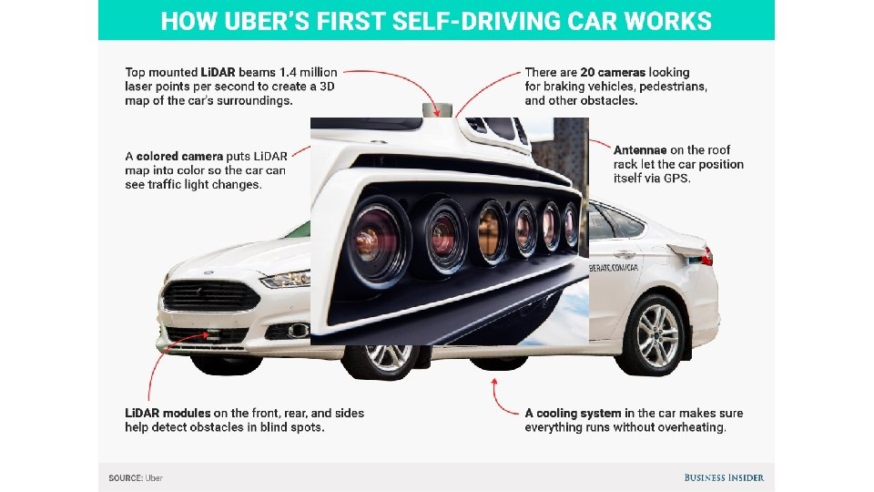
Tesla and Waymo Tesla • • • Camera Radar Ultrasonic sensor Ask buyer to pay $8, 000 for “Full Self-Driving Capability” Installed on Model S, X, 3 Needs to be low cost enough to attract buyers Model 3 start around $35, 000 Read speed limits, drive on road Level 2. 5 ish Claims the system can handle level 5 People skeptic about lack of LIDAR Waymo • • Camera Radar LIDAR Launched since 2009, “DARPA” Partnering with car manufactures Chrysler Pacific Mini Van In-house sensors, everything 10% of original cost of LIDAR => $75, 000 *10%=$7, 500 per unit • Each car has 3 LIDAR, ride-sharing • Hi-definition Map, pre-record every street the car will be driving • Working on level 5
Smart Cities • Use large amount of sensors to monitor the city • Connected things/ internet of things • Weather, crowd density, etc. • Infrastructure condition • Traffic light • Road surface condition
Intelligent Transportation Systems • Part of Smart Cities • Traffic Management Systems • Traffic jam • Parking space
Connected Vehicles Lu, Ning, et al. "Connected vehicles: Solutions and challenges. " IEEE internet of things journal 1. 4 (2014): 289 -299.
Vehicle to Vehicle • V 2 V • Not limited to only between vehicles • V 2 I (vehicle to infrastructure) • Hybrid of V 2 V and V 2 I
RSU: Road Side Unit Maglaras, Leandros A. , et al. "Social internet of vehicles for smart cities. " Journal of Sensor and Actuator Networks 5. 1 (2016): 3.
Challenges • Which vehicle should you talk to? • Communication bandwidth • Where should the data being processed? Cloud or vehicle? • Internet unavailable • Attack on the network
Directly to Font Vehicle • Use front vehicle’s camera to allow object see-though • Bandwidth? Gomes, Pedro, Cristina Olaverri-Monreal, and Michel Ferreira. "Making vehicles transparent through V 2 V video streaming. " IEEE Transactions on Intelligent Transportation Systems 13. 2 (2012): 930 -938.
Visible Light Communication • Talk to nearby vehicles, limited information Cailean, Alin-Mihai, et al. "A survey on the usage of DSRC and VLC in communicationbased vehicle safety applications. " Communications and Vehicular Technology in the Benelux (SCVT), 2014 IEEE 21 st Symposium on. IEEE, 2014.
Industry Products • Google Map, Here Map • Real-time traffic data • Street view • Waze • Community map • Mobileye • Road Experience Management ™ (REM™)
But • Even vehicle to vehicle can not eliminate uncertainty • Motion planning needs to take care of
Simple Intuition • Stop the vehicle • Wait till the sensor gives certain measurement • Not practical • Some cases cannot be measured • Other vehicles always have a possibility to break rule
Work on Obstacle
Work on Obstacle • Minkowski Sum
Work on Obstacle
Close Loop Real-time Re-planning Sense Plan Move
Other Methods • Markov Decision Process Model • Motion planning with conservative constrains
Probability Model • Treat front wheel angle as prior data • Calculate trajectories based on the probability model • Find the path that has no or low probability of collision
Sun, Hao, et al. "Trajectory planning for vehicle autonomous driving with uncertainties. " Informative and Cybernetics for Computational Social Systems (ICCSS), 2014 International Conference on. IEEE, 2014.
Motion Planning Under Uncertainty • Predict other vehicles’ path use local planner • Calculate uncertainty along the path using Gaussian Propagation • The uncertainty from localization and control is estimated based on Linear-Quadratic Gaussian (LQG) framework
Sun, Hao, et al. "Trajectory planning for vehicle autonomous driving with uncertainties. " Informative and Cybernetics for Computational Social Systems (ICCSS), 2014 International Conference on. IEEE, 2014.
Sun, Hao, et al. "Trajectory planning for vehicle autonomous driving with uncertainties. " Informative and Cybernetics for Computational Social Systems (ICCSS), 2014 International Conference on. IEEE, 2014.
Summary • Sensors: LIDAR, camera, radar, ultrasonic • Each has its own limitations • Fusion is not easy • Use V 2 V, V 2 I for “superman” sensing • Network management • Universal standard • Trying to minimize uncertainty • Planning under uncertainty • Simple model • Prediction • Probability distribution
Thanks! Shiwei Fang